Argentina
Dual Exchange Rates, European Influence, Che & Messi, Lake District Splendour, Patagonia Steppe & The End Of The World
Laguna de los Tres, Parque Nacional Los Glaciares, Patagonia, Argentina. November 4, 2015
Argentina
The world’s eight largest country, home to 40 million but one of the least densely populated countries on earth. Best known as a beef exporter, it’s also a leading producer of wine and with a society dominated by football/soccer, politics & living life in the fast lane. Here is a recap of my travels through the country as posted from the road at the time with, where applicable, links to dedicated location postings.
Read all postings from the road in chronological order or jump to specific postings using these links.
– NORTH & CENTRAL – Border Crossing/First Impressions, Salta, Rosario, Cordoba, & Mendoza
– LAKE DISTRICT – San Martin de Los Andes, Ruta 40 & Bariloche
– PATAGONIA – Ruta 3 & Ruta 5 & Parque Nacional Los Glaciares (Perito Moreno Glacier/El Calafate and Fitz Roy/El Chalten)
– TIERRA DEL FUEGO – Ushuaia
– THE CAPITAL – Buenos Aires
Archived Postings From The Argentinean Road (In Chronological Order)
BORDER CROSSING & FIRST IMPRESSIONS
Date || September 5, 2015
Location || Salta, Argentina ( )
)
It was an absolute mare of a day yesterday: up at 5 a.m. for a bumpy 7-hour bus ride through dusty southern Bolivia – there are no paved roads connecting the Bolivian towns of Uyuni & Tupiza, just desert tracks; my friend, a South African, getting blatantly ripped-off by corrupt Bolivian Immigration officials crossing the border into Argentina – I avoided any border fine shenanigans thanks to that Irish/EU passport of mine; discovering Argentina has the potential to be unnecessarily expensive thanks to a whole Venezuela-esque dual currency exchange rate thing that they have going on – a law-abiding ‘official’ rate, which currently gets you 10+ ARS (Argentine Pesos) to the €, & an unofficial, illegal so-called ‘blue’ rate that gets you 16+ Pesos to the €; seven more hours on 2 different Argentinian buses, including a nighttime customs check in the middle of nowhere. All that for an arrival in the Argentinian city of Salta, my present location, at the ungodly hour of 4:30 a.m., almost a full 24 hours after setting out from the Bolivian town of Uyuni some 700 kilometres to the north. It’s no fun arriving anywhere at that hour, let alone a strange town in a thus far strange country. As I said, a mare of a day, something you experience on the road every now and then – it’s not all cocktails & sunsets.
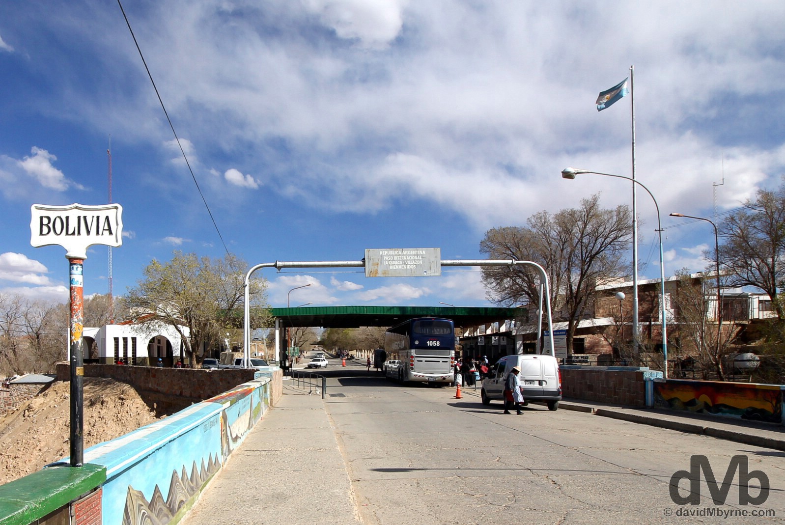
Crossing into Argentina, South America county number 6, from the dusty Bolivian border town of Villazon. At the Villazon/La Quiaca Bolivia/Argentina border crossing. September 4, 2015.
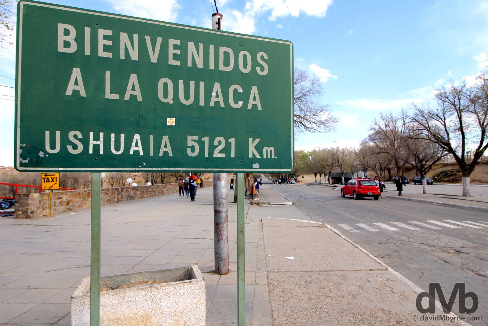
5121 kilometres. North to south. Just over the border into the Argentinian border town of La Quiaca from Bolivia is the ‘5121 kilometres to Ushuaia’ sign. The city of Ushuaia, in the (very) southern Argentine (& Chilean) province of Tierra del Fuego, is billed as the the southernmost city in the world, a big draw for travellers, travellers who also know it as the jumping off point for once-in-a-lifetime trips to Antarctica. I plan on getting there sometime in mid-November (UPDATE: I arrived in Ushuaia on November 11, 2015, to find the equivalent sign in Ushuaia proclaiming that La Quiaca is 4987 kilometres away. ‘Umm, which sign is lying?’ I wondered), a ways away yet with lots to see before that; I’ll be crisscrossing the continent (I’m en route to east to Paraguay, southern Brazil & Uruguay before heading back through Argentina & into Chile) as I ultimately head south including, of course, my jaunt 3500 kilometres out into the Pacific to Easter Island. On the Argentinian side of the Argentina-Bolivia border. September 4, 2015.
So Argentina, and now that I’m rested & have the southern Bolivian dust out of my system, show me what you’ve got?
SALTA
Date || September 7, 2015
Location || Salta, Argentina ()
It’s good to be in Argentina. OK, so the dual exchange rate is annoying but the people are friendly, the sun has been out, there’s lots of infrastructure (& an absence of dust), & everything is ordered, clean and works.
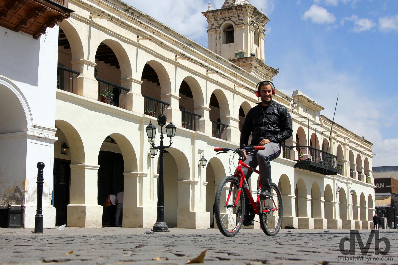
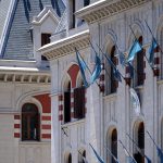
All smiles cycling past the Cabildo on Plaza 9 de Julio, Salta, northern Argentina. September 7, 2015.
Yes, there’s a very different feel to things here compared to we’re-underdeveloped-but-making-a-fist-of-things Bolivia further north. But I knew that would be the case. Everyone knows Argentina is very European – 97% of Argentinians are of European origin, mostly of Spanish & Italian descent, & thus European influence runs deep here in easily the most European country in South America. But, & granted Argentina for me thus far has only been Salta, I still didn’t expect it to be as European as it is; it has jokingly been quipped that Argentina is the most American of European countries. It’s comforting &, being honest, just what the doctor ordered after the last few months of travelling through oh-so-South-American Peru & Bolivia, even allowing for their obvious and substantial colonial-era charms.
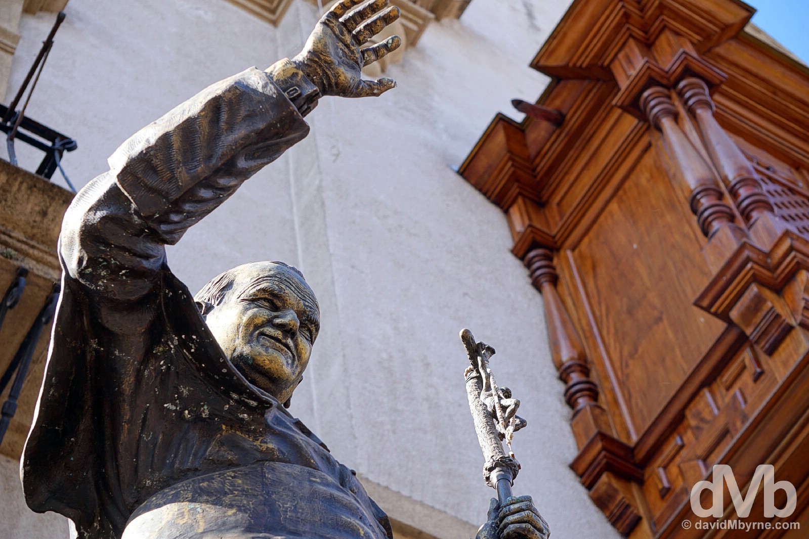
A statue of Pope John Paul II outside the Catedral overlooking Plaza 9 d Julio in Salta, northern Argentina. September 6, 2015.
Salta
The first taste of Argentina for many tends to be its cosmopolitan capital Buenos Aires. Mine just happened to be Salta, the tourism capital of Argentina’s northern region and somewhere I’d never heard of until a few days ago. Founded in 1582, the city boasts an abundance of well-preserved & nicely restored colonial architecture, most of which is to be found surrounding one of Argentina’s most harmonious plazas, Plaza 9 de Julio. It has a cable car, always a tourist favourite, which showcases the city’s dramatic setting. And there are museums a plenty, including the best in the Argentinian north, the somewhat controversial MAAM, Museo de Arqueologia de Alta Montana (Museum of High Altitude Archaeology). So all in all as an introduction to the country I guess I could have picked a lot worse.
Plaza 9 de Julio
Salta’s city centre square is one of Argentina’s most harmonious plazas. With the requisite mounted statue at its centre, the plaza is overlooked by some impressive buildings & is surrounded on all four sides by shady arcades that house various café & restaurant terraces.
Nowhere does Salta feel more European then here in its central square, Plaza 9 de Julio. At most hours of the day its cafes are full with people sitting around & lazing over a coffee while discussing the day’s affairs and/or reading the paper. It’s a super place to while away a few lazy hours and an even better place to beautiful people-watch. I had breakfast overlooking the plaza both mornings I was in the city. Bolivia felt a millions miles away when sitting here with my sunglasses on sipping my cafe con leche – at times I felt like I was in Plaza Mayor, Madrid or Piazza San Marco/St. Mark’s Square, Venice. The tree-heavy plaza itself doesn’t photograph too well (too much foliage) but the buildings surrounding it certainly do. This is a picture of one of a portion of the facade of one of the plazas standout buildings, the Centro Cultural America. Plaza 9 de Julio, Salta, northern Argentina. September 7, 2015.
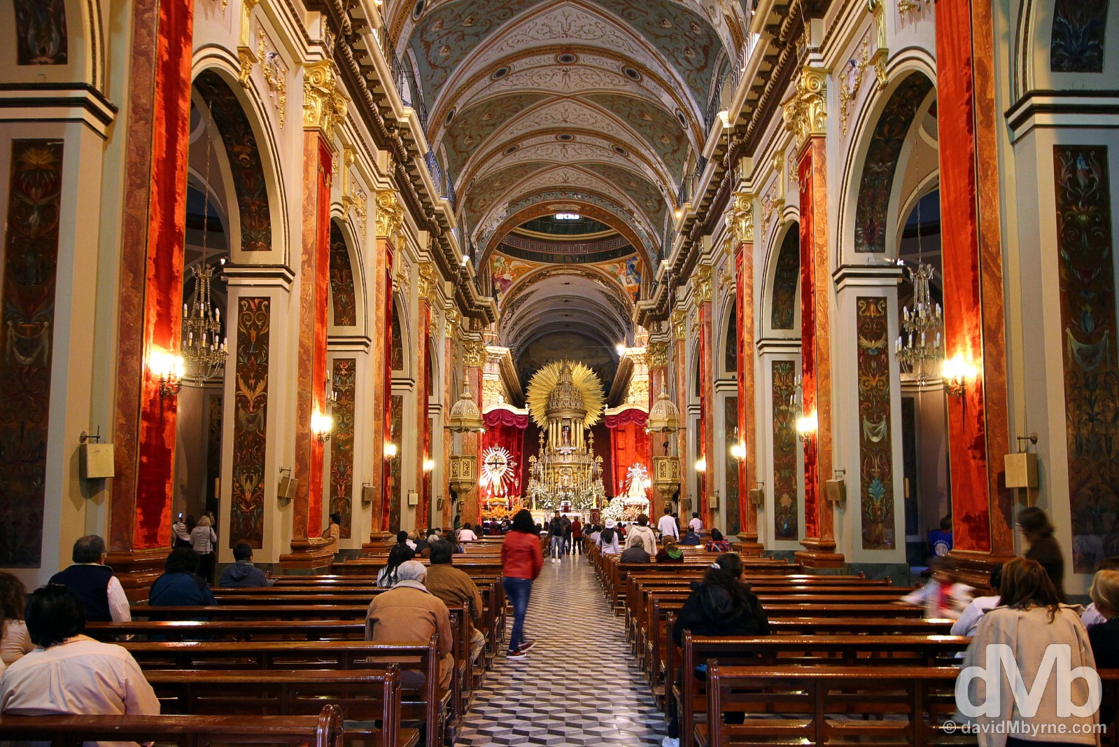
The interior of the Catedral on Plaza 9 de Julio in Salta, northern Argentina. September 5, 2015.

Also located on Plaza 9 de Julio is MAAM, Museo de Arqueologia de Alta Montana (Museum of High Altitude Archaeology), a fascinating albeit somewhat eerie affair that controversially displays three impeccably preserved Incan children – although only one is on display at any given time – that were discovered high up a lofty volcano. Needless to say pictures of the museum stars, displayed behind thick glass in high-tech fridges, are strictly prohibited. However, there are no such restrictions in the museums gift shop where this picture was captured. MAAM, Museo de Arqueologia de Alta Montana (Museum of High Altitude Archaeology) in Salta, northern Argentina. September 6, 2015.
Iglesia San Francisco
As impressive as the buildings surrounding Salta’s Plaza 9 de Julio are – & they are – the colonial highlight of the city is the gorgeous Iglesia San Francisco, a couple of blocks off the plaza.
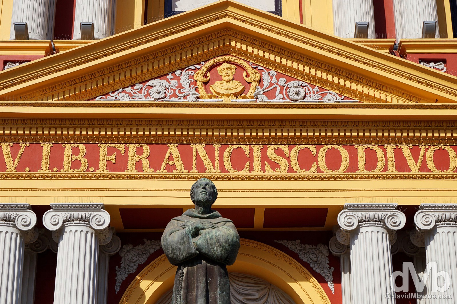
The Neoclassical Iglesia San Francisco is not only Salta’s most striking building but it is also one of the most beautiful religious buildings in the country (seemingly, I’ve little to compare it to as of yet). Built between 1750 & 1850, it’s an extravaganza if Italianate Neocolonial exuberance. Pure ivory-white columns stand out from vibrant ox-blood walls with braid-like golden lettering. An accompanying towering campanile is also a standout feature, one that was covered in scaffolding when the church was posing for my camera. Iglesia San Francisco, Salta, northern Argentina. September 6, 2015.
Teleférico San Barnardo Cable Car
Salta’s dramatic setting is best appreciated from upon high. Enter the Teleférico San Barnardo Cable Car, probably the city’s number one attraction.
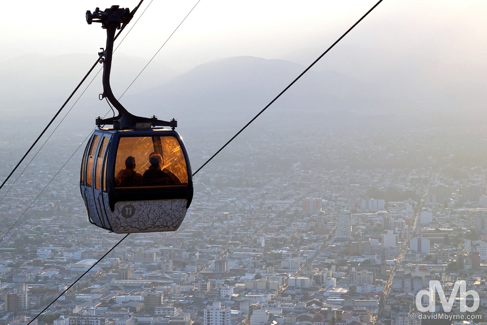
If you want nice views of the city sprawl & distant peaks then best get up here in the morning. If you want to play with light by silhouetting the cable car pods against the setting sun directly ahead, blowing out any decent views of the city itself, then get up here in the late afternoon, or around about the time I was there. Either way it’s a Salta must-do. The Teleférico San Barnardo cable car overlooking Salta, northern Argentina. September 6, 2015.
ROSARIO
Date || September 22, 2015
Location || Rosario, Argentina ()
After a little under two weeks of travel through Paraguay, southern Brazil & Uruguay, I’m back in Argentina. A short ferry ride from the Uruguayan town of Col Del Sacramento to the Argentine capital of Buenos Aires followed by a 4-hour bus ride sees me here in Rosario, Argentina’s third largest city.
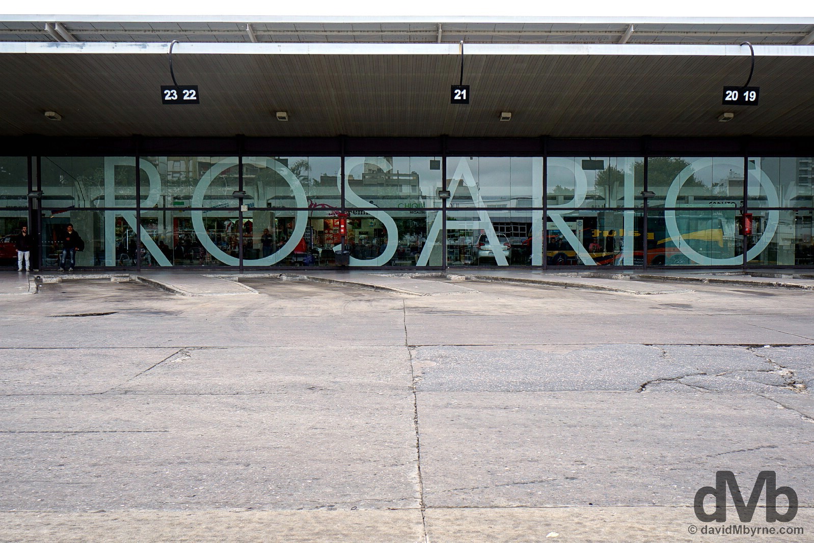
Terminal de Omnibus, Rosario having just stepped off the 4-hour bus from Buenos Aires. Needles to say I’ve seen a lot of bus stations over the last few months. The Rosario one just happens to be the very latest not to mention one of the greatest thanks to its huge window lettering. Rosario, Argentina. September 21, 2015.
Rosario || Cuna de la Bandera
Rosario is a vibrant & stylish port city on the Rio Parana – Rough Guides uses the word ‘beguiling’ when describing it. Boasting more than a few parks & cobbled leafy streets, it also has some impressive architecture, including one of the country’s most famous monuments, the Monumento a la Bandera (The National Flag Monument), a huge stone monstrosity in the shape of a boat that pays homage to the distinctive sky-blue & white Argentine flag, created in the city in 1812 – Rosario is officially known as Cuna de la Bandera, or Birthplace of the Flag.
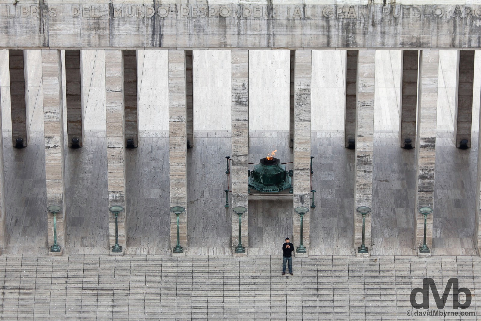
Adorning the back of the Argentine ten-peso note, the massive Monumento a la Bandera is easily Rosario’s standout attraction & reason enough, in my opinion, to pay the city a visit. Finished in 1957, it’s a huge 10,000 m² structure that’s hundreds of metres long, the approximate outline of which mimics that of a ship – representing Argentina – sailing towards a glorious future. Nice. A three part monument, this picture of a man on the steps of the structure’s central eternal flame-boasting Triumphal Propylaeum, which represents the Nation as organized after the 1853 Constitution, was captured from the lookout in the monument’s 70 metre-high Tower, or mast, which both commemorates the anti-Spanish Revolution of May 1810 & houses the crypt of the flag designer, Manuel Belgrano. Monumento a la Bandera, Roasrio, Argentina. September 22nd, 2015.
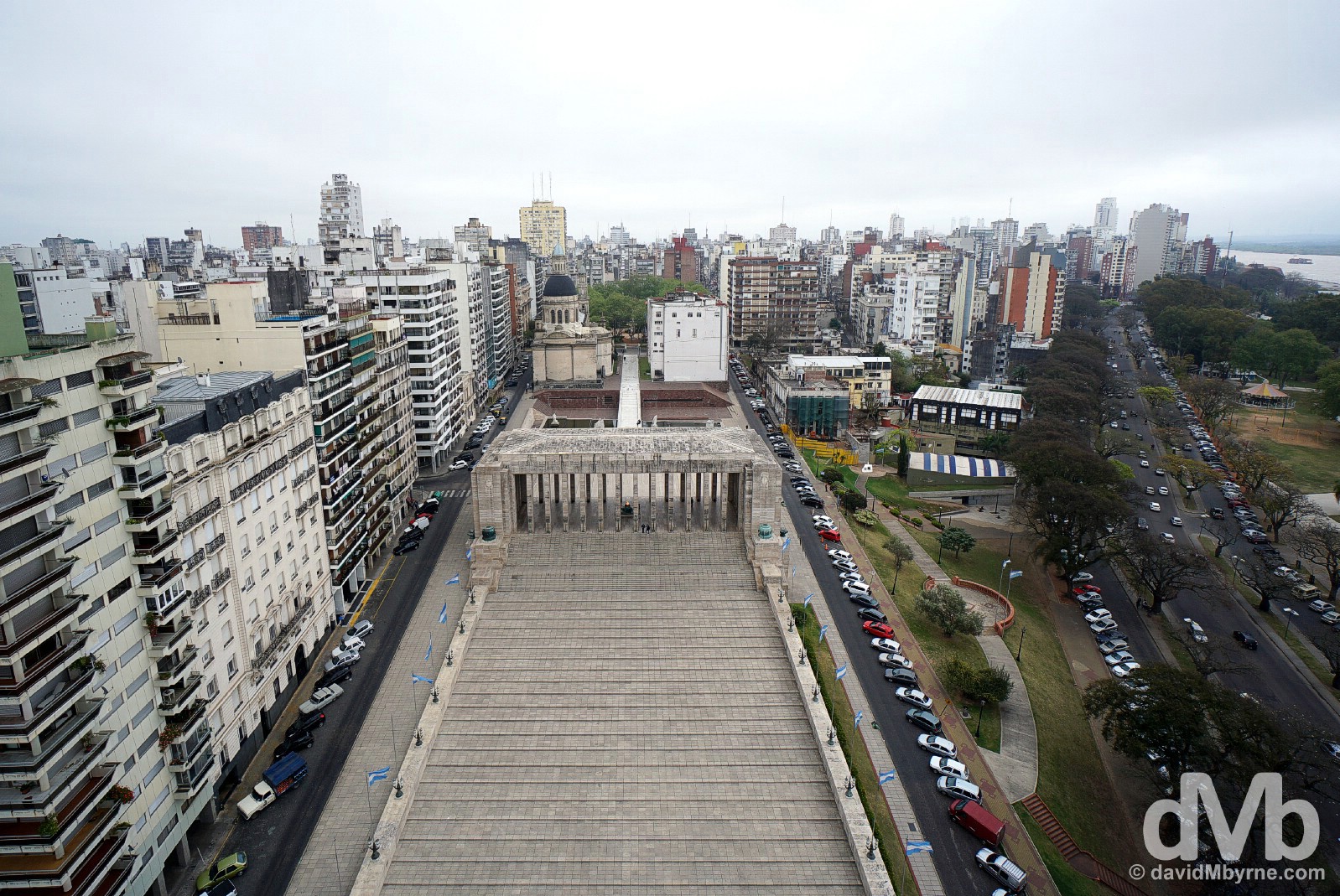
The views over Rosario, a somewhat flattish riverside city & port on the banks of the Rio Parana, from the Monumento a la Bandera’s Tower are rather impressive, even if the day itself was unpleasantly dull & overcast. The views aside, from this vantage point you can clearly see the ship outline of the monument, something that’s hard to appreciate from ground level. Rosario as seen from the Tower of the Monumento a la Bandera. Roasrio, Argentina. September 22, 2015.
– Roberto Fontanarrosa (1944-2007), Argentine cartoonist and writer & Rosario local
Seemingly Rosario is renowned throughout Argentina for the beauty of its female residents. Umm, can’t say I’ve noticed. Trust me, I always notice the pretty girls and I’d especially notice an abundance of them.
Rosario’s Famous Sons || Che & Messi
Rosario is the birthplace of two rather famous Argentinians, Lionel Messi, born here in 1987, & Ernesto ‘Che’ Guevara, born in the city in 1928.
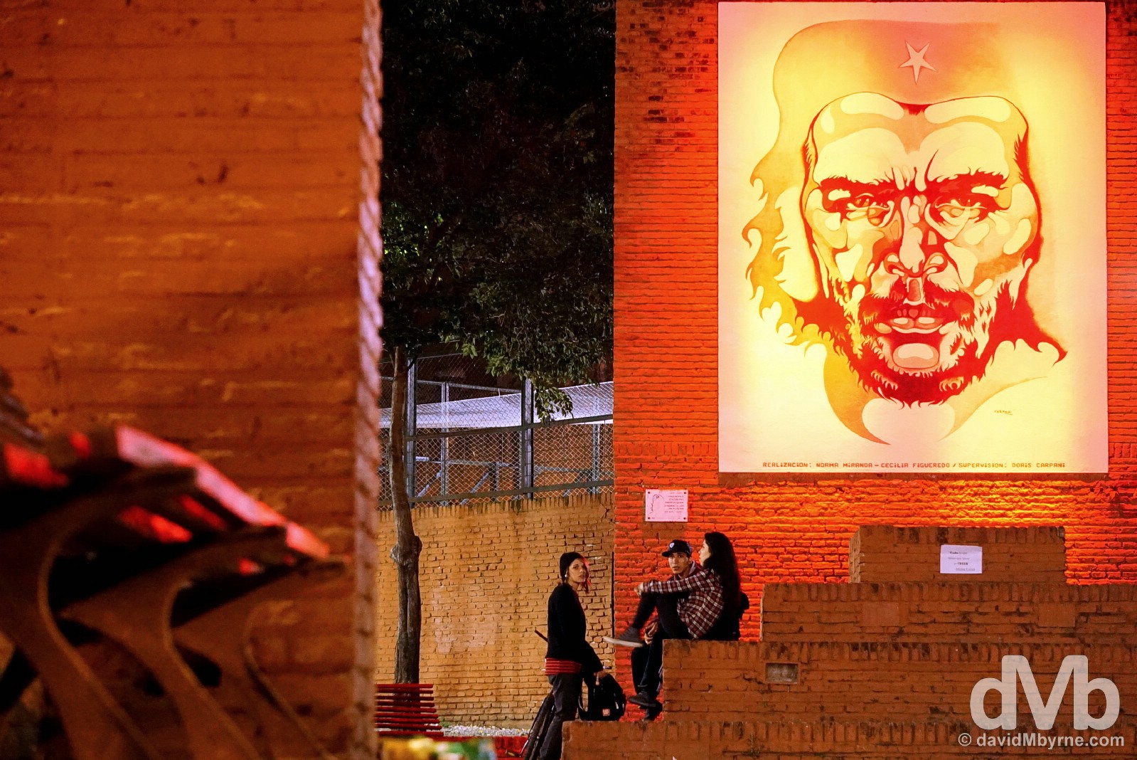
Revered as a hero elsewhere, especially Cuba where he fought most of his battles, Che Guevara seems somewhat ignored by his own hometown. The city does have an official bronze statue to the iconic revolutionary figure & probably its most famous son but it’s located in a somewhat forlorn looking park, renamed ‘Plaza Ernesto ‘Che’ Guevara’, well out of the way on the outskirts of the city. Only erected in 2008 and unveiled to commemorate what would have been Guevara’s 80th birthday, the memorial was not funded by government but rather by donations from around the world – one gets the impression that the authorities are rather embarrassed about Che & his goings-on. It’s not a particularly attractive monument in a not very attractive setting, meaning it didn’t photograph very well. This setting, an illuminated Guevara-inspired mural in a small square off Mitre street in Rosario’s city centre, & while not an official memorial, proved much more photogenic. Hanging out in a park off Mitre street in Rosario, Argentina. September 21, 2015.
See more on Che Guevara as posted from Santa Clara, Cuba, Che’s final resting place and a city that does have a Che mausoleum.
Go West || Stop 1 of 3 || Mustn’t crumble of course but it has been cold, overcast and altogether a tad uninviting here in Rosario – I haven’t seen the sun in a few days. I’m passing through the city en route to Santiago, Chile, for a September 27 flight to Easter Island. Rosario is my first stop of three in Argentina as I head west – the cities of Cordoba & Mendoza will be coming up before the week is out – & I’m hoping the weather improves as I do. But again as I said, mustn’t grumble. On the chilly cobbled streets of Rosario, Argentina. September 22, 2015.
CORDOBA
Date || September 24, 2015
Location || Cordoba, Argentina ()
I failed in my bid to get money changed on the streets of Rosario, my previous stop in Argentina. There were no hoodwinks, no scrupulously subdued chimes of cambio from shady characters on street corners, outside ATM bays or in the entrance to shopping arcades, their favoured hangouts. It seems the clandestine money changers on the ground in Rosario were just a bit too clandestine for me. There were no such financial shortcomings here in Cordoba and within a few hours of taking to its busy streets I was looking over my shoulder as I surreptitiously handed over USD$300 for which I received the total of 4,650 Argentinian Pesos (15.50 Pesos to the dollar). Job done. For now.
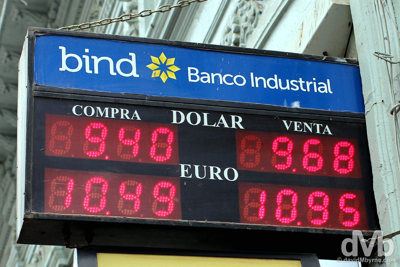
Of course you could change your money through official channels – at official money exchanges. Or you could withdraw money from an ATM, just like I was forced to in Rosario. Both are plentiful but both use the official exchange rate, presently seen here as 9.40 Pesos to the dollar or 10.49 to the Euro. At that rate I’d have received 2,818 Pesos for my US$300, a good bit short of the 4,650 Pesos I received on the street. Needless to say at the unofficial exchange rate, a.k.a. the Blue rate, Argentina is a lot more affordable than it otherwise would be, which is why I withdrew close on US$2,000 from ATMs in Uruguay over the past week ahead of my return to the country. What it all means is that the 30 Peso coffee I just enjoyed cost me €1.70, not almost €3, my 140 Peso-a-night bed is costing me €8, not €13, & the 670 Peso 10-hour overnight bus ticket I’ve just purchased to Mendoza, my next stop, is costing me €38, not €63. Quite the saving. The listed ‘official’ exchange rates on the streets of Cordoba, Argentina. September 23, 2015.
Cordoba || Stop 2 of 3 || Argentina’s Colonial-era Second City
When I was finally moneyed up it was time to set about taking a look around Cordoba, Argentina’s second city. There were very few surprises here – Cordoba follows the same tried & tested formula for most colonial Latin America towns of any size, that being a grid layout of north to south & east to west streets & avenues with a compact church-heavy historic downtown, the centre of which is marked by a leafy central plaza – in Cordoba that’s Plaza San Martin – overlooked by an impressive cathedral & surrounded by an array of colonial-era architecture. It’s all very same same. I haven’t tired of the repetition yet but I’m getting there.
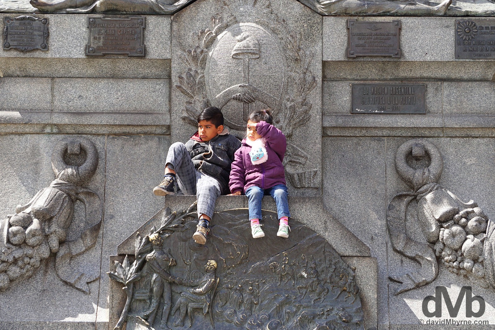
Hanging out in Plaza San Martin, the centre of Cordoba’s colonial heart. The plaza is watched over by a massive mounted bronze statue of the Liberator atop a massive & decorative stone plinth that 1) was unveiled in 1916 to commemorate the centenary of the declaration of Argentine independence, & 2) can be used as a perch for some of the city’s younger residents if need be. Plaza San Martin, Cordoba, Argentina. September 24, 2015.
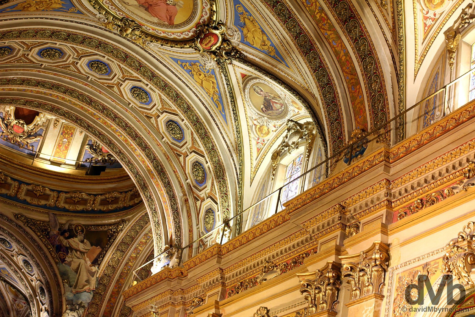
Cordoba’s cream-coloured 18th century part Baroque, part Neoclassical cathedral is one of Argentina’s oldest & most beautiful churches, inside & out. The structure’s external facade, with its two matching bell towers, gets a lot of attention but I was particularly taken by the decorative overload of the cathedral’s Italian Baroque-inspired interior, especially the walls and ceiling, a portion of which is shown here. The Cathedral on Plaza San Martin in Cordoba, Argentina. September 23, 2015.
Manzana Jesuitica
Cordoba’s Manzana Jesuitica is a collection of well-preserved Jesuit buildings, remnants from the Argentinian Jesuit days – the whole block (manzana means block) was apportioned to the Jesuits a decade after the city’s founding in July 1573. The complex of buildings that survives to this day, one of which is the oldest Jesuit church in Argentina, is one of the city’s colonial-era jewels &, more importantly, the only city-based UNESCO World Heritage site in Argentina.
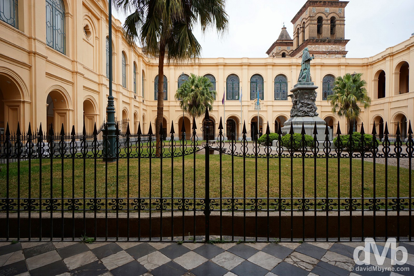
Most of the present-day Manzana Jesuitica is in the control of the Universidad Nacional de Cordoba, Argentina’s oldest university dating to 1610. Open as a museum, the Museo Historico Unc Manzana Jesuitica, the complex, the central courtyard of which is seen here, contains, among other delights, Argentina’s oldest surviving Jesuit church, the Iglesia de la Compania de Jesus (built between 1640 & 1675), & a library housing a priceless collection of maps religious work & late fifteenth century artefacts. Manzana Jesuitica, Cordoba, Argentina. September 23, 2015.
– UNESCO commenting on the Jesuit Block and Estancias of Córdoba
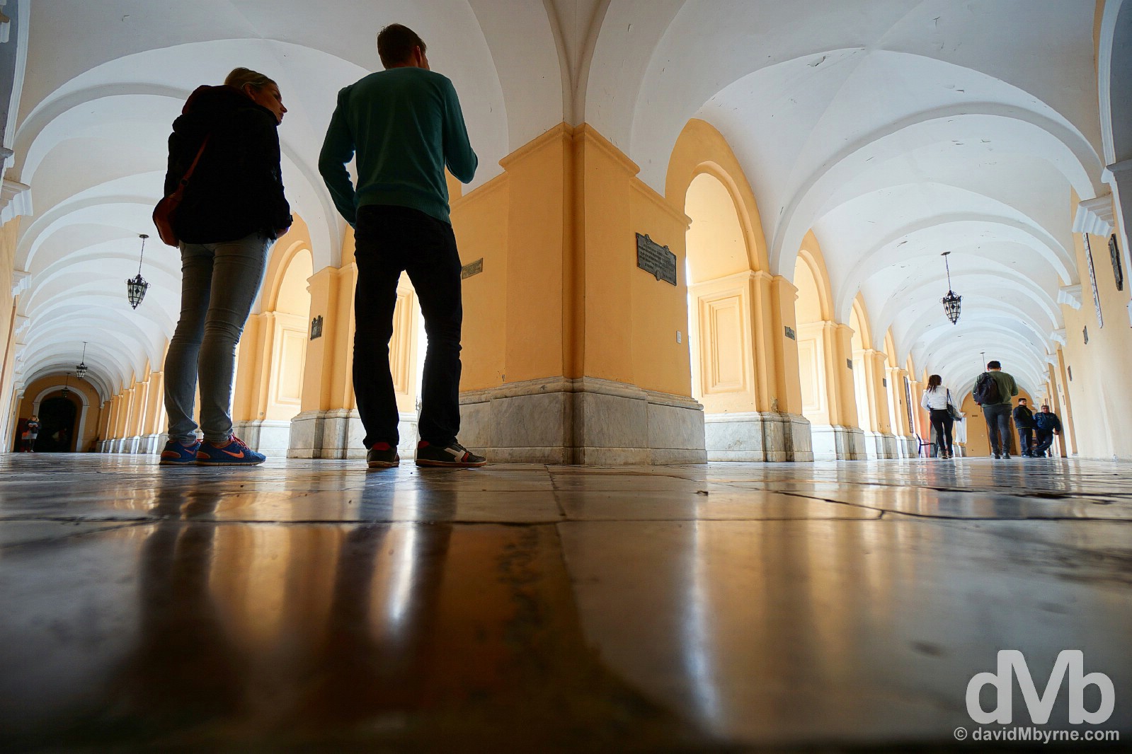
In the portico surrounding the central courtyard of the Manzana Jesuitica complex in Cordoba, Argentina. September 23, 2015.
The sun wasn’t out much during my time in Cordoba. That said, it did make an appearance for a few hours this afternoon. Things looked so much prettier as a result, especially the cream-coloured cathedral.
The upper portions & immense cupola of Cordoba’s cathedral & a flag pole as seen from a sunny Plaza San Martin. Cordoba, Argentina. September 24, 2015.
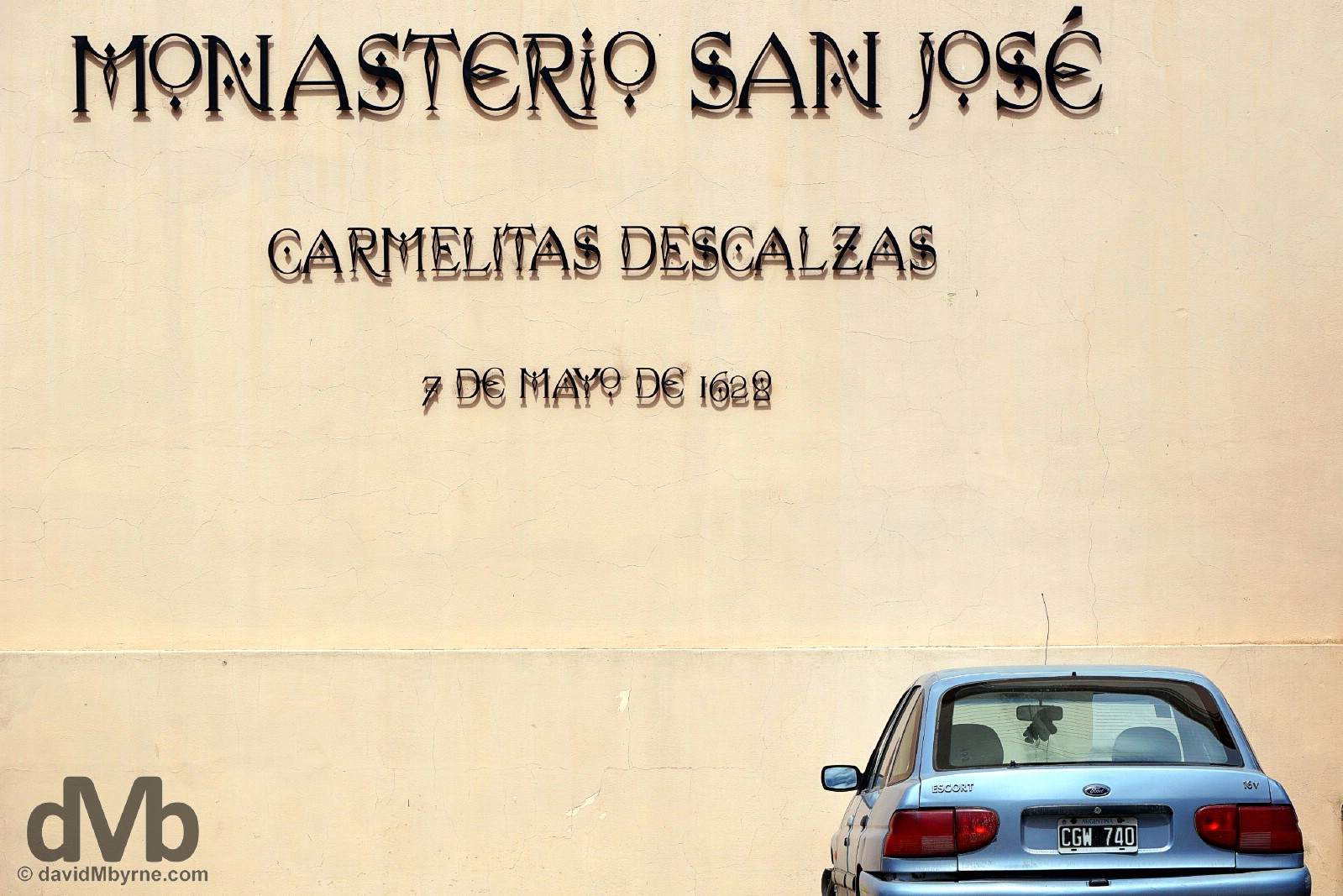
The 1628 Monastero San Jose, a working Carmelite monastery in Cordoba, Argentina. September 24, 2015.
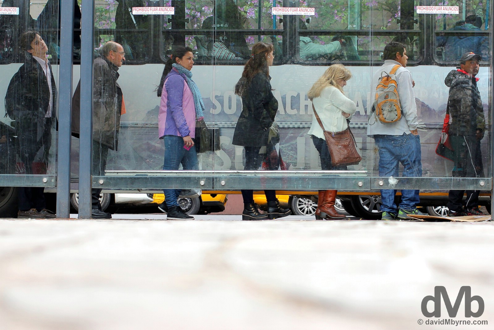
Queuing for the bus on San Jeronimo, Cordoba, Argentina. September 23, 2015.
MENDOZA
Pictures from Mendoza, Argentina’s wine capital.
-
- The Monument to the Spanish discovery of the New World in Plaza de Espana, Mendoza. Argentina. September 25, 2015.
-

- At the foot of the General San Martin statue in Plaza San Martin, Mendoza, Argentina. September 25, 2015.
-

- Tiling detail on the Monument to the Spanish discovery of the New World – depicting Columbus’s discovery on October 12, 1492, of the New World when sighting a Bahamian island – in Plaza de Espana, Mendoza. Argentina. September 25, 2015.
-
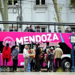
- A city tour bus off Plaza Independencia in central Mendoza, Argentina. September 25, 2015.
-
- Plaza Chile, Mendoza, Argentina. September 25, 2015.
-

- A leafy street in Mendoza, Argentina. September 25, 2015.
-

- Off Plaza San Martin in Mendoza, Argentina. September 25, 2015.
LAKE DISTRICT - SAN MARTIN DE LOS ANDES, RUTA 40, & BARILOCHE
Date || October 19, 2015
Location || Bariloche, Patagonia, Argentina ()
According to many a traveller here in Bariloche, the Patagonian scenery further south is better. More rugged, less Idyllically alpine, more untouched. Just ‘better’. Whether that’s the case or not, my first taste of Patagonia proper has been nothing short of spectacular & if indeed it does get better than this then both me & my camera(s) are in for quite the visual treat over the coming weeks.
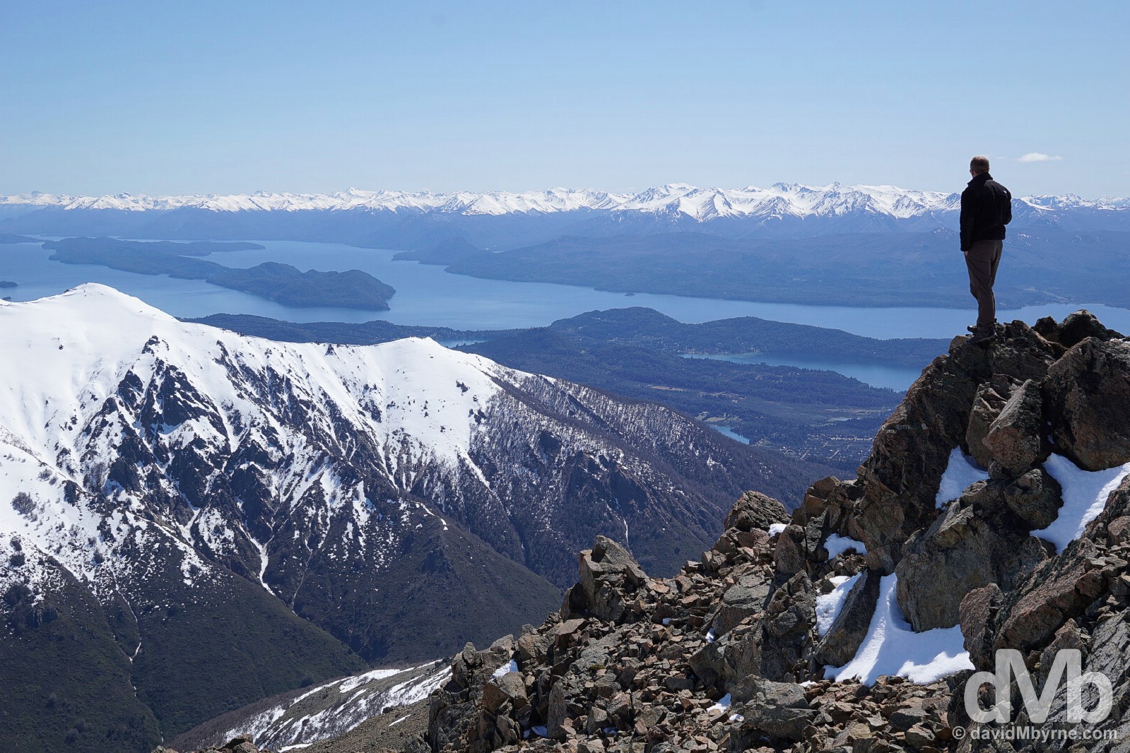
On a high on Cerro Catedral in Parque Nacional Nahuel Huapi, northern Patagonia, Argentina. October 16, 2015.
Argentinian Lake District || San Martin de Los Andes & Bariloche
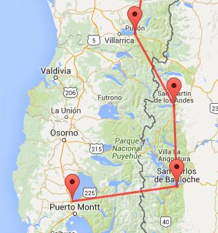
My cross border Lake District shuffle || Pucon (Chi) – San Martin de Los Andes (Arg) – Bariloche (Arg) – Puerto Varas (Chi)
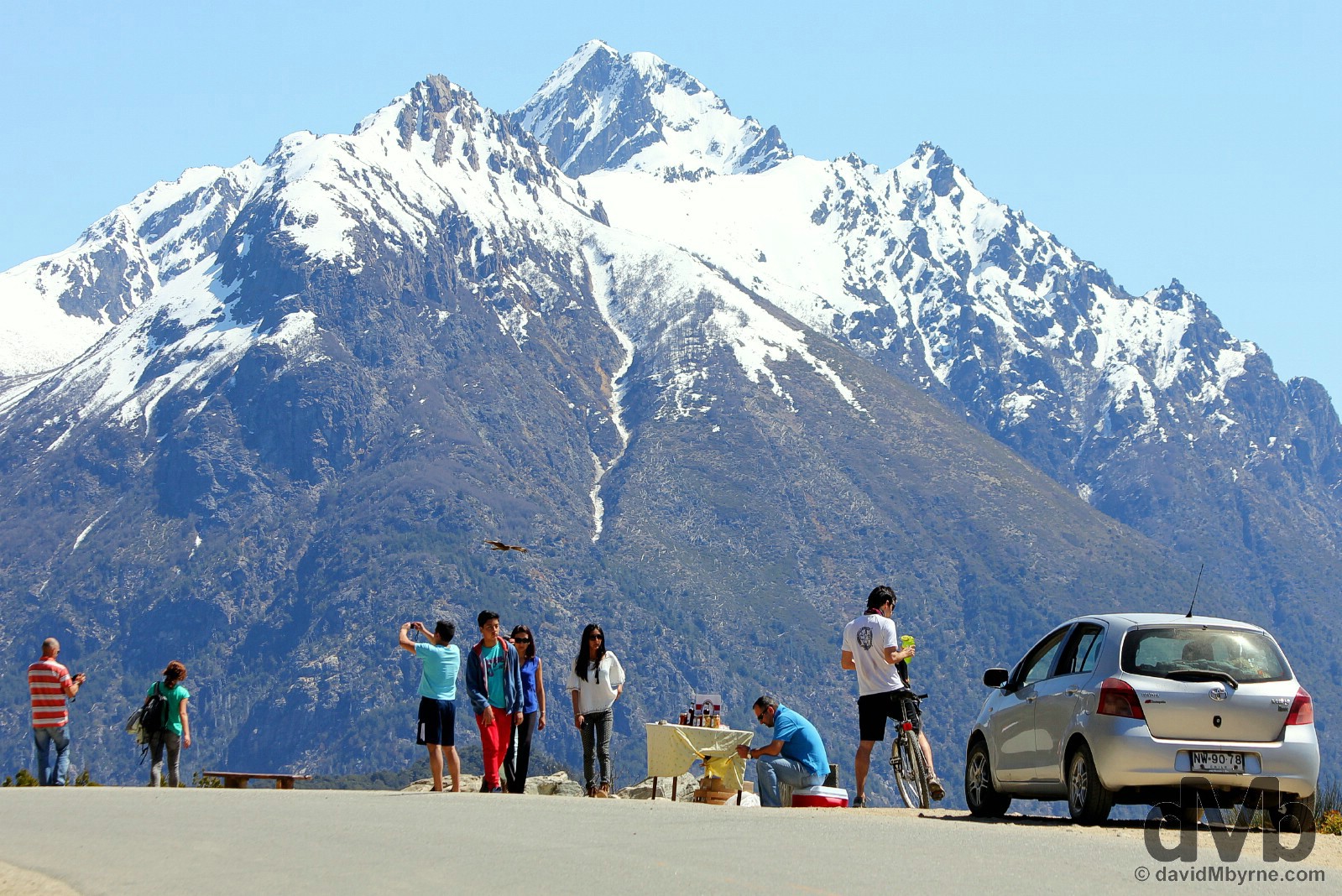
I left the mountain-enshrouding clouds & rain of Pucon in the Chilean Lake District behind, crossing over the Andean border into the Argentine Lake District, & northern Patagonia (& Patagonia proper), in a bid to actually see some mountains, to see some lakes. It worked, & quickly too. Almost as soon as I passed over the Hua Hum Pass, which at 660 metres is one of the lowest international passes between the two countries, the clouds dispersed. That was 6 days ago now (October 14) & I’ve barely seen a cloud since. The favouriable climatic conditions have made this region of picture-perfect glacial lakes, luxuriant forests, jagged peaks & extinct volcanoes all the more picturesque. Argentina’s Switzerland, a region of lakeside towns full of wooden chalet architecture, craft beer breweries, chocolate shops & dairies, was once a remote wilderness controlled by indigenous peoples. However, today it’s Argentina’s modern alpine holiday region, one I’m sad to be leaving as I prepare for a return to the clouds of the Chilean Lake District.
San Martin de los Andes & Ruta 40
My first stop in Patagonia proper was the small but charming lakeside town of San Martin de los Andes. I came here hoping to climb the 3,776 metre-high Lanin volcano, the jewel of the nearby Parque Nacional Lanin. The €400 asking price to do so was/is almost as steep as the snow-draped volcano’s perfectly conical slopes, meaning I passed on that little indulgence thus limiting my time in town to only one night. It may be small but San Martin de Los Andes still has room for an Irish bar. About as Irish as the Dalai Lhama & with prices more suited to Monaco (€9 for a Heineken), the Dublin South Pub sits on the town’s Avenue San Martin at Kilometre 2212 of Argentina’s famous Ruta 40.

Argentina’s very own Route 66, Ruta 40 is the country’s longest road, stretching as it does for 5224 kilometres from the Bolivian border in the north to the southernmost point on the Argentine mainland beyond the (very) southern city of Ushuaia. The very first thing Argentinian I saw having crossed a few feet over the Argentina-Bolivia border back in early September was the ‘5121 Km to Ushuaia’ sign. Some 40 days later, & having crisscrossed the continent in the meantime, I’ve only 2,909 kilometres to go (UPDATE: I arrived in Ushuaia at the very end of Ruta 40, and the world, on November 11, 2015). Kilometre 2212 on Ruta 40 in San Martin de los Andes, northern Patagonia, Argentina. October 14, 2015.
Bad #dog! Breaking the rules today in #Lake Lacar, #SanMartindelosAndes #Patagonia #Argentina #travel @VisitArg pic.twitter.com/zkxHI3XFOm
— davidMbyrne.com (@ByrneDavidM) October 16, 2015
Bariloche
After San Martin de Los Andes it was off south to Bariloche. Officially San Carlos de Bariloche (everyone dispenses with the San Carlos bit), this is the region’s principle town with a population of over 100,000. Situated in the foothills of the Andes and nestling on the southern shores of Lago Nahuel Huapi & on the edge of the trekking & skiing haven of Parque Nacional Nahuel Huapi, the town, somewhat hidden in the Andes, was once an Andean backwater & the reserve of the indigenous locals. It wasn’t until the 30s & 40s that the transformation began to turn it into what it is today – a major tourism centre, one busy year-round but one jam packed with foreign & domestic holidaymakers during the southern hemisphere’s December to January high summer.
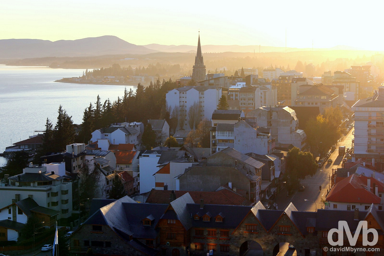
Sunrise over Bariloche, northern Patagonia, Argentina. October 16, 2015.
Heavy today on alpine-styled architecture and traveller comforts & conveniences, Bariloche is the sort of place you’ll plan on spending a few days but could easily while away a few weeks. And if, as I did, you do end up spending more time here than planed then it’s highly likely the result of the jaw-dropping scenery & the general all-encompassing Andean splendour you’re thrust into; it’s a tough environment to voluntarily remove yourself from.
– The Rough Guide to Argentina on Bariloche
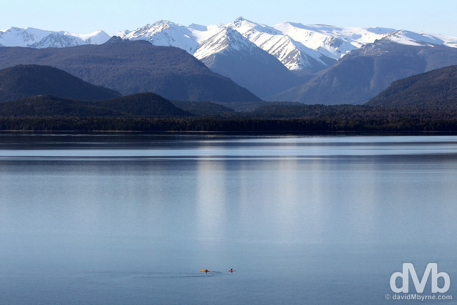
Kayaking on 557 km² & highly irregular in shape Lago Nahuel Huapi as seen from Bariloche, northern Patagonia, Argentina. October 17, 2015.
Bariloche grew from being a centre of cattle trade that relied on commerce with Chile, to becoming a tourism centre for the Argentine elite. The city took on a distinctive & cosmopolitan architectural and urban profile as a result of a number of urban public works carried out in the 30s & 40s. Among them is perhaps the city’s best-known feature, its European-inspired Centro Civico, Civic Centre.
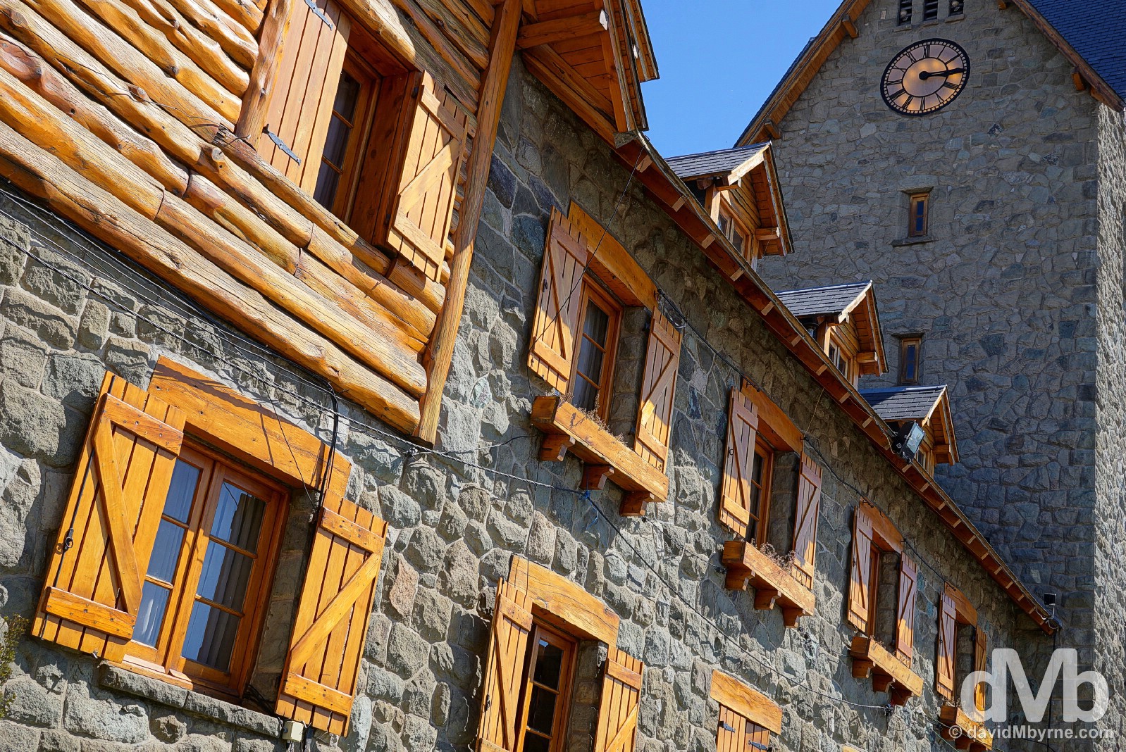
Inaugurated in March 1940 and declared a Argentinian National Historical Monument in 1987, Bariloche’s Centro Civico/Civic Centre is the city’s standout architectural highlight, running the impressive Catedral Nuestra Senora del Nahuel Huapi into second place. An impressive & picturesque set of buildings surrounding a broad plaza, itself the focal point of the city, it was constructed in the late 1930s from timber & local greenish-grey stone (volcanic toba). Designed by architect Ernesto de Estrada, it was the first civic centre in Latin America. Its U-shaped design, which was inspired by buildings in the Swiss capital of Bern, is open to Lago Nahuel Huapi & incorporates a clock tower with numerous arches, pitched roofs, arcades, balconies & terraces. Centro Civico in Bariloche, northern Patagonia, Argentina. October 17, 2015.
Parque Nacional Nahuel Huapi || Cerro Catedral & Circuito Chico
Right on Bariloche’s doorstep is Parque Nacional Nahuel Huapi, one of Argentina’s largest protected wilderness areas, and with clean, crisp alpine air & idyllic scenery at every turn, it’s also one of its most popular – Rough Guides calls it the ‘doyen’ of Argentine National Parks – its two big miss-them-at-your-peril draws being the craggy peaks of Cerro Catedral & the blissfully scenic loop of the Circuito Chico.
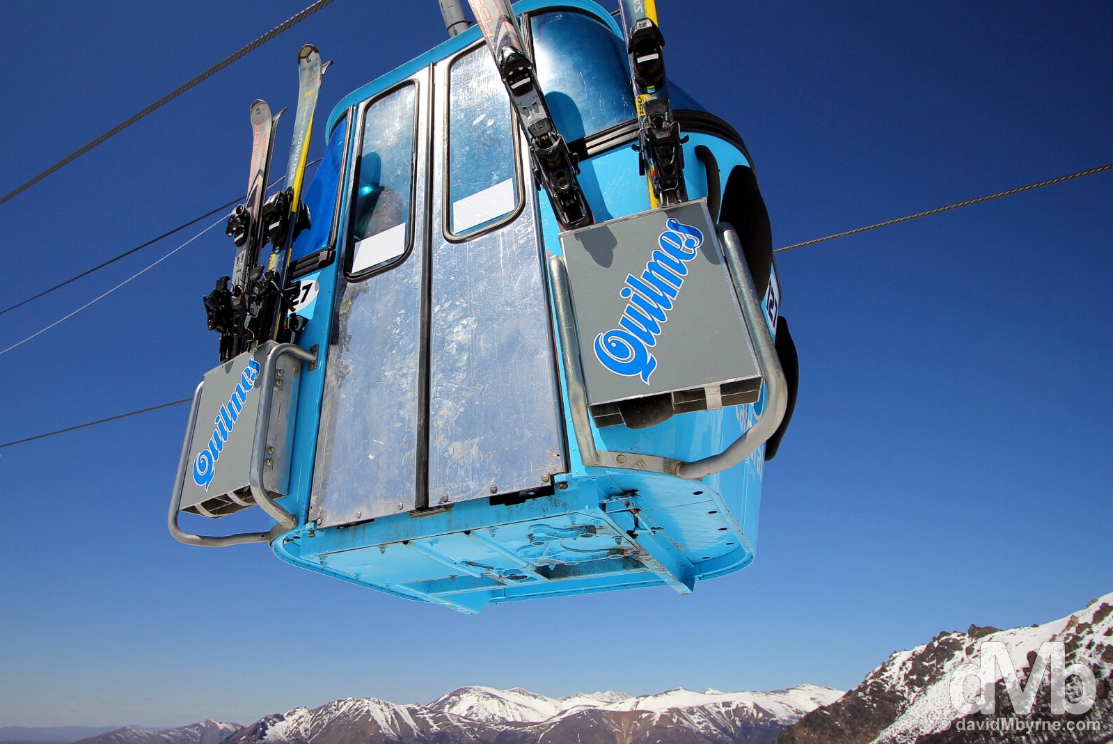
Ski lift of the Catedral Alto Resort on Cerro Catedral in Parque Nacional Nahuel Huapi, northern Patagonia, Argentina. October 16, 2015.
Cerro Catedral
A haven for trekkers in summer & skiers in winter, in-between seasons – around about now when the slopes are closed to the skiing fraternity – Cerro Catedral accommodates the likes of me, those who use the skiing infrastructure to access the paths & peaks of the parks highest reaches from where there are fabulous views of far-off craggy mountains & rich blue lakes. I mean, really, really fabulous.
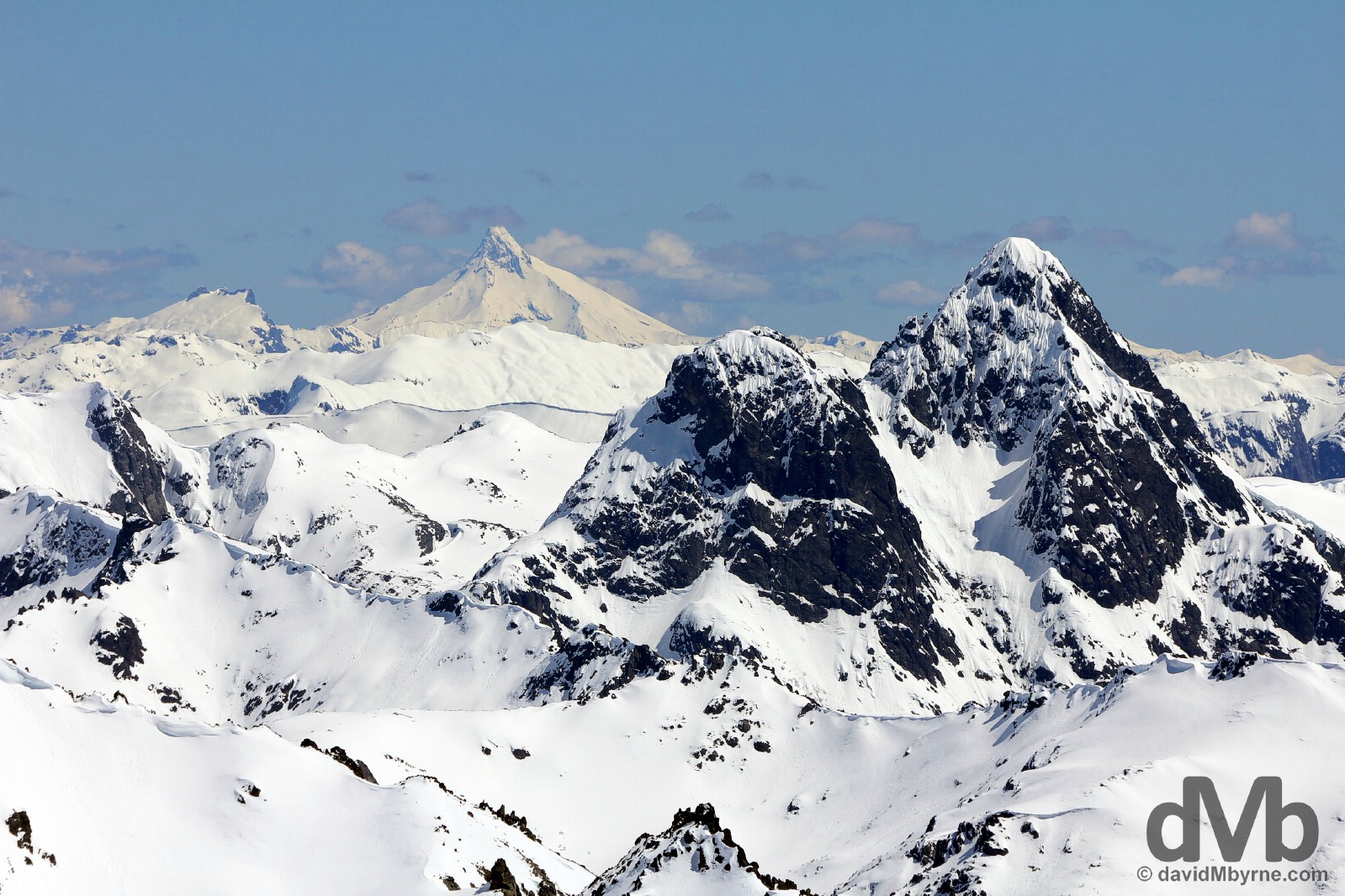
Mountain vista as seen from the Cerro Catedral massif in Parque Nacional Nahuel Huapi, northern Patagonia, Argentina. October 16, 2015.
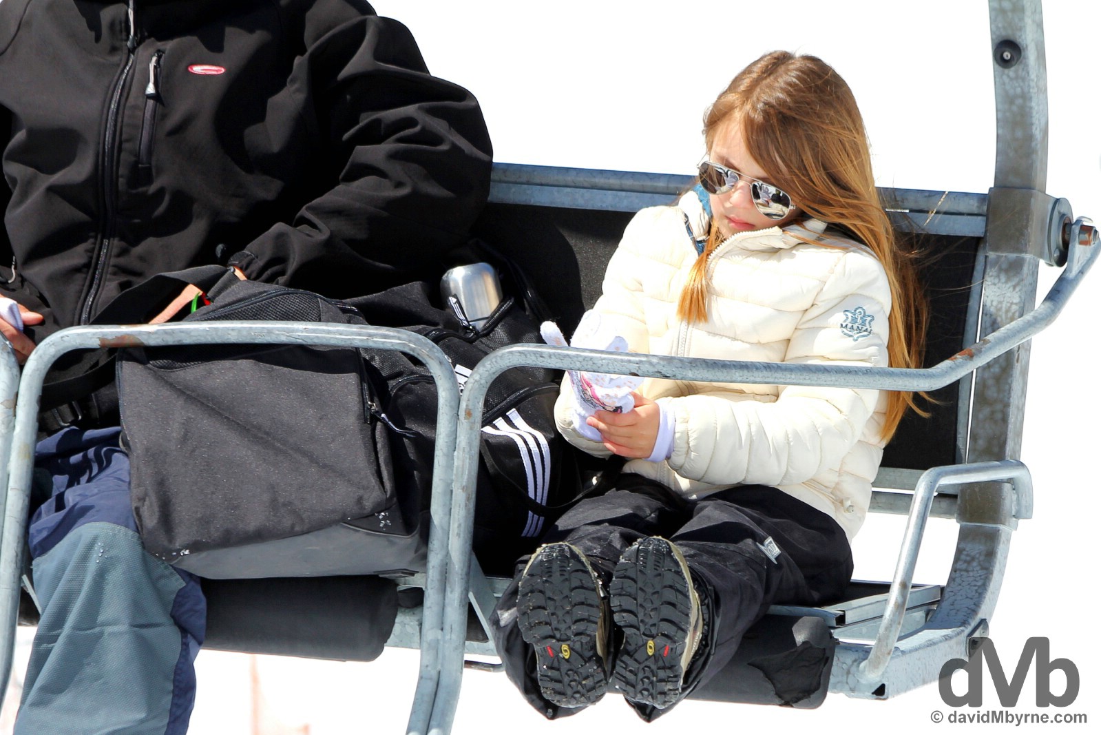
Access to Cerro Catedral is via the chairlifts of the Catedral Alta Resort, South America’s largest skiing facility – it boasts of having some 120 kilometres of ski runs suitable for all levels & an efficient ski lift system capable of hauling some 35,000 skiers up into the hills every hour. As with all such establishments, this resort attracts the moneyed classes; even the kids up here are super cool sporting their mirrored Aviator sunglasses. I didn’t feel out of place at all. Cerro Catedral in Parque Nacional Nahuel Huapi, northern Patagonia, Argentina. October 16, 2015.
I wasn’t the only person up here brandishing a camera. Cerro Catedral in Parque Nacional Nahuel Huapi, northern Patagonia, Argentina. October 16, 2015.
Cerro Catedral, Parque Nacional Nahuel Huapi, northern Patagonia, Argentina. October 16, 2015.
Circuito Chico || On Your Bike
Even coming down from the highs of Cerro Catedral doesn’t lessen the scenic thrills. Parque Nacional Nahuel Huapi’s so-called Circuito Chico is a 65 kilometre up/down up/down road that loops a section of the central portion of the vast park, passing by beautiful lakes, around towering peaks & through scented pine forests. Public bus is an easier option, car even easier. I, and always a glutton, tackled it on a bicycle, grateful for the many scenic respites provided en route.
At the Lago Moreno Oeste lookout on the Circuito Chico. One of my first stops on the circuito, the views of lakes & peaks from this point were beyond fairytale-esque. But being midday on a crystal clear day meant the washed-out scene didn’t photograph well. Circuito Chico, Parque Nacional Nahuel Huapi, northern Patagonia, Argentina. October 18, 2015.
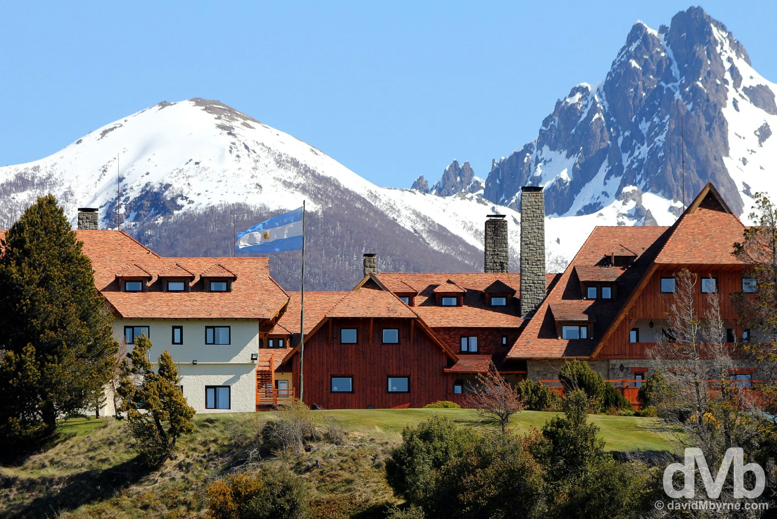
Perched proudly atop a knoll, the Llao Llao Hotel is one of Argentina’s most famous hotels & an obligatory stop on the Circuito Chico. Originally built in the late 1930s & designed to resemble a Canadian cabin, it burnt down less than a year after completion, the result of an unfortunate meeting between a candle and an inattentive & subsequently-relieved-of-her-duties housekeeper. Reopened in 1940, it was state owned until 1991 but is now in private hands. Needless to say all rooms come with killer views (not to mention a hefty price tag). Circuito Chico, Parque Nacional Nahuel Huapi, northern Patagonia, Argentina. October 18, 2015.
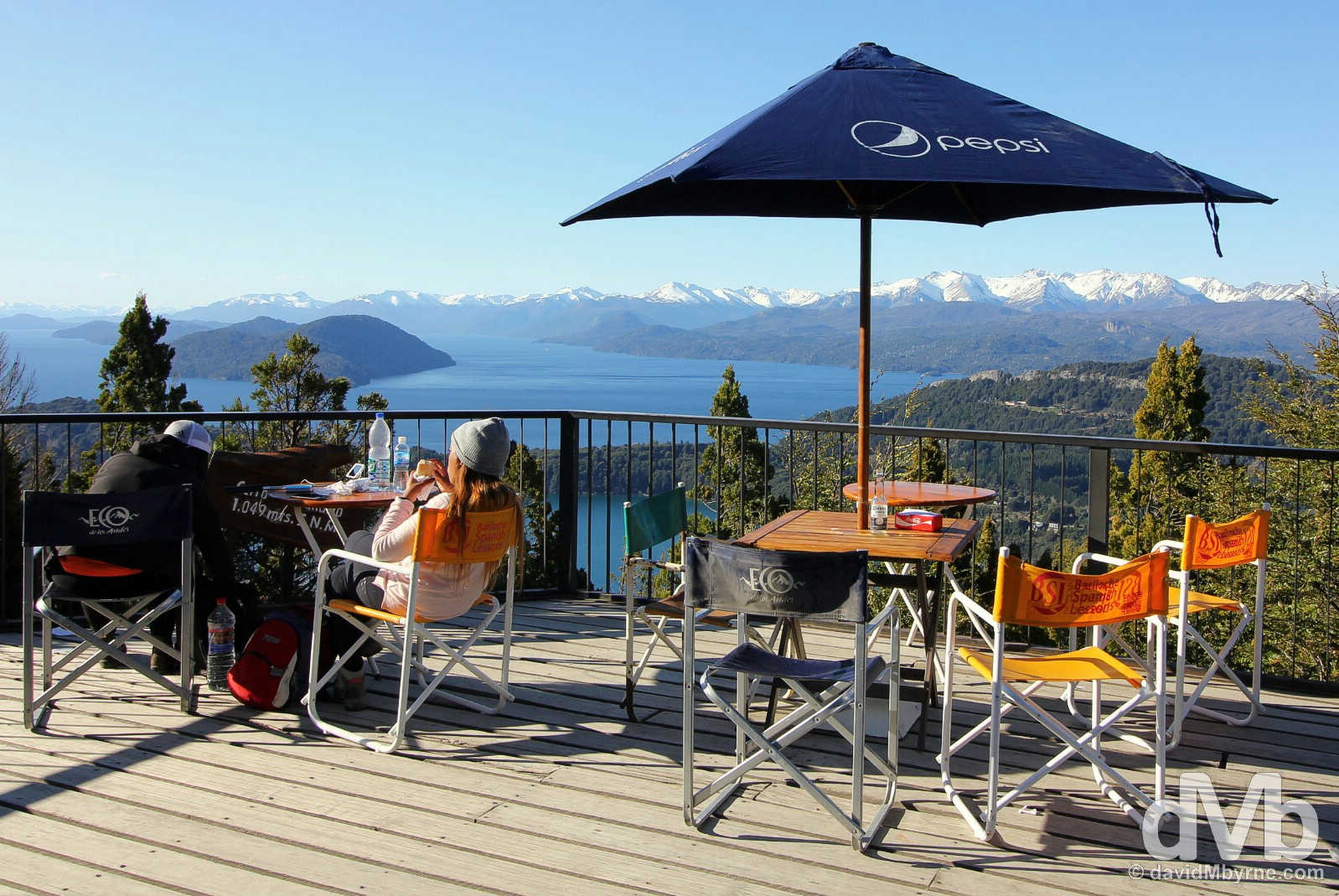
Rehydration time on the terrace of Cerro Campanario, a panoramic 360-degree lookout with awesome views of the whole region & one of the most popular of the Circuito Chico stops. Parque Nacional Nahuel Huapi, northern Patagonia, Argentina. October 18, 2015.
So there we have it. Patagonia gets better than this? That remains to be seen, & excuse me if I remain skeptical, but boy am I ever looking forward to finding out.
PATAGONIA - RUTA 3 & RUTA 5
Date || November 1, 2015
Location || El Calafate, Santa Cruz, Argentina ()
It was quite the jaunt to get here to El Calafate from the Rio Jeinimeni border crossing with Chico Chile in Chile further north (although not really that far north).
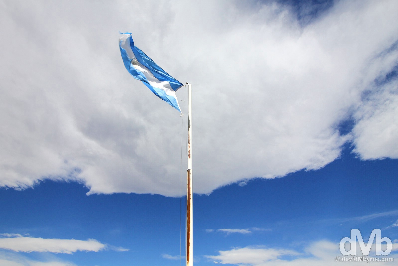
The Argentinian flag flying at the very blustery Rio Jeinimeni border crossing between Chile Chico, Chile & Los Los Antiguos, Argentina. October 31, 2015.
Chile Chico to El Calafate || The Scenic Route
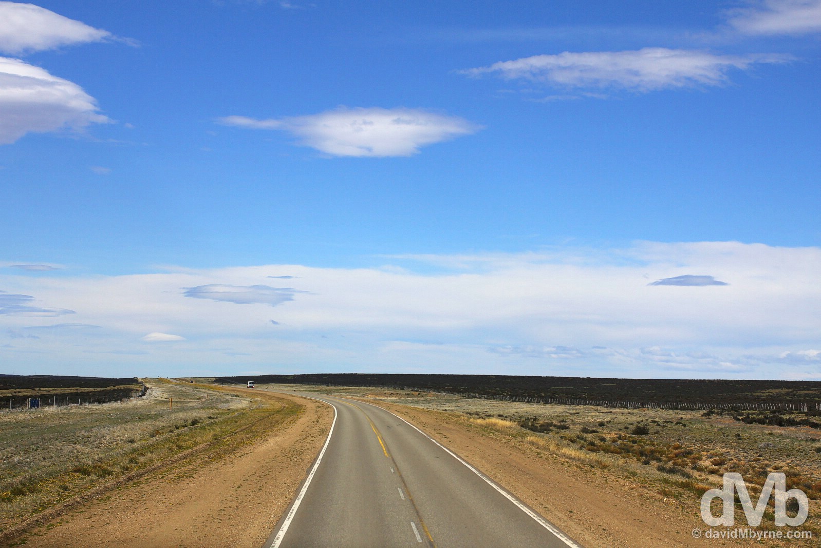
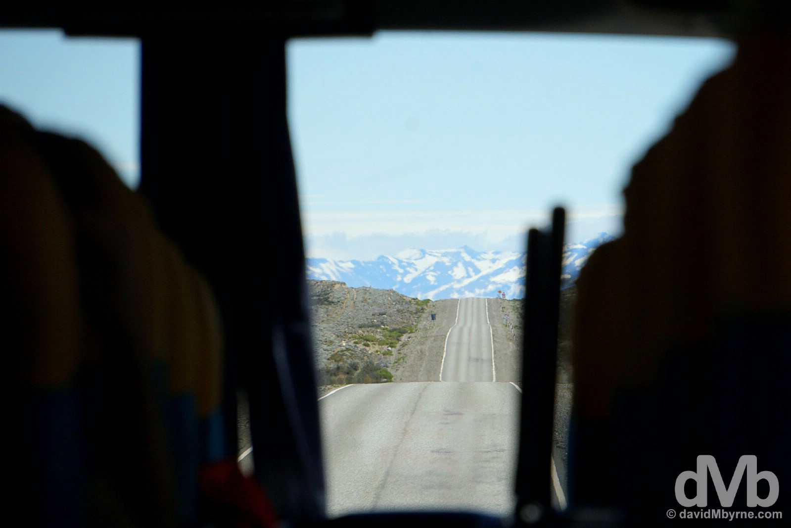
All told, door to door, it took 27 hours to get from the border to here in El Calafate (via Perito Moreno & Rio Gallegos). Six and a half of those 27 hours were spent waiting for buses, the other twenty-one and a half hours were spent in transit. It needn’t have taken that long but, & in a bid to prevent prolonging the wait in lifeless bus terminals, I hopped on the next available bus from Perito Moreno, one that took me all around the houses. Yes, I took the scenic route as it were from A to B, from B to C, and then from C to D, when going direct from A to D would have done nicely, thank you very much.
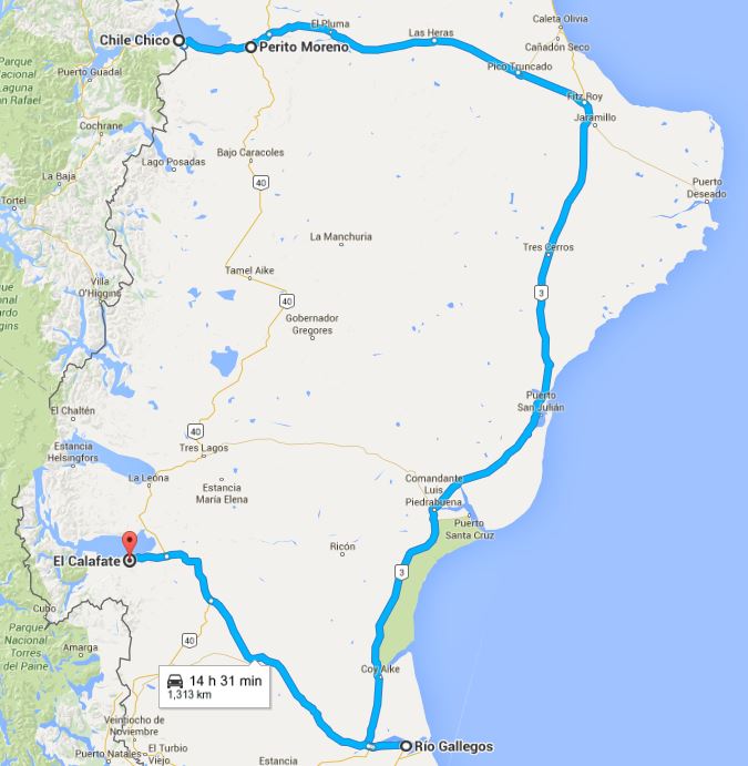
My first choice was to head south, and south only, via Ruta 40 from Perito Moreno to El Chalten, a 700 kilometre, 13-hour bus trip (Google says you can do it in a car in 8 hours). But, & with no such direct bus available, at least not for a few days, if at all, I ended up going, as seen here, east to join the coastal Ruta 3, the world’s southernmost highway, before then heading south to Rio Gallegos & then west on Ruta 5 to the runner-up destination of El Calafate, a 1,313 kilometre trip that took 18 bus hours (Google estimated 14 and a half car hours).
I boarded that 18-hour bus yesterday in Perito Moreno in the twilight hours. The portion of the trip during daylight hours today saw me travelling on long straight roads through the irksome Patagonian steppe, first in a southerly direction on Ruta 3, then in a westerly one on Ruta 5. There’s a strange hypnotic charm to the sight of endless grassy expanse. It’s not particularly interesting & certainly not what I would class as photogenic. That said, I enjoyed the trip. It surprised me & I surprised myself by taking some pictures I liked, even from behind the dirty windows of a moving bus.
Ruta 3 || Southward on The World’s Southernmost Highway
Ruta 3, the world’s southernmost highway, is the main artery connecting Ushuaia in Argentinian Tierra del Fuego, a.k.a. El Fin del Mundo (the End of The World), to the capital Buenos Aires. Although called a coastal route, it rarely gets close enough to the Atlantic Ocean to actually see it. I never intended to be even in the vicinity of the Atlantic in getting from the Chilean border to El Chalten, both in (very) western Patagonia on the (very) western side of the continent (granted things are narrowing as I head further south in the so-called South American Southern Cone but still).
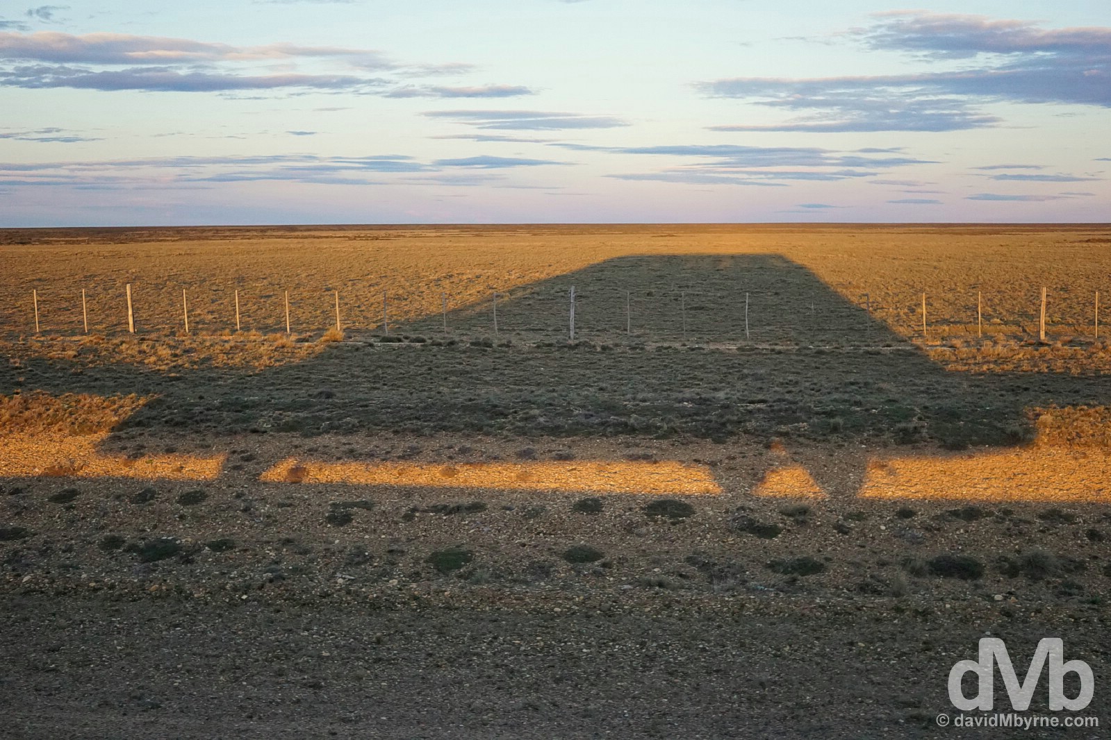
06:17 || I woke early today, just after 5 a.m. Sunrise was still an hour away & when it came, as it does from the east, it cast armadillo-shaped shadows of the bus across the Patagonian steppe to the west as the bus headed south down the Ruta 3 towards Rio Gallegos. Bus shadows on Ruta 3 in Patagonia, southern Argentina. November 1, 2015.
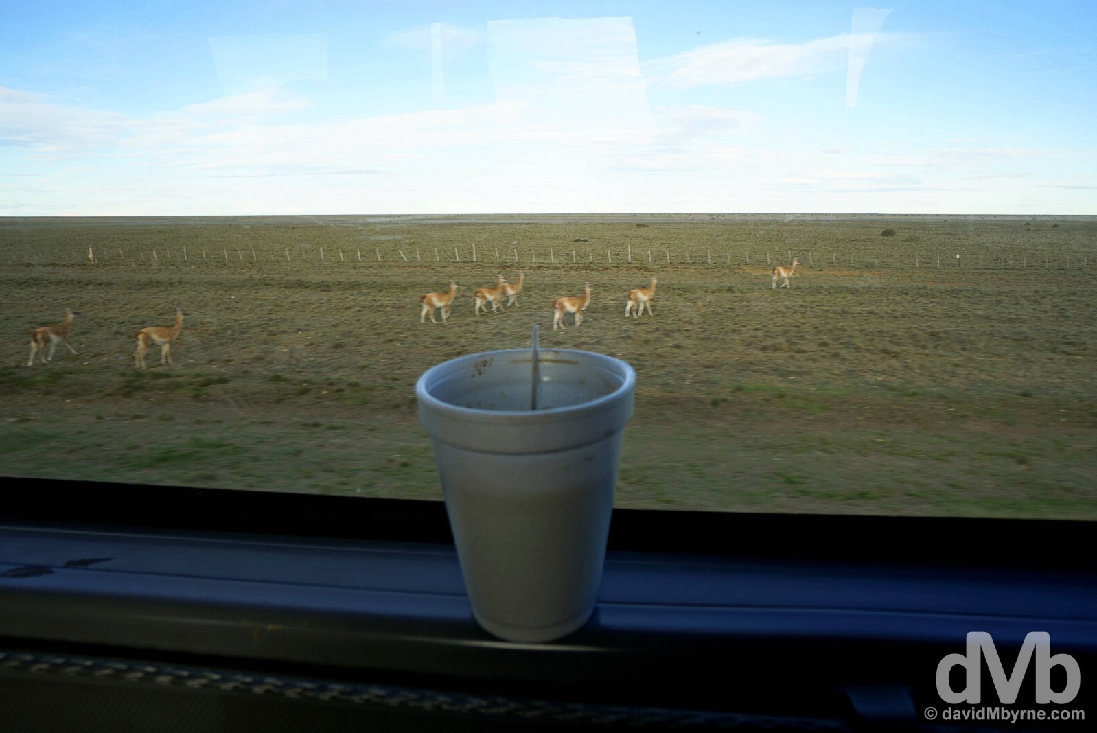
07:47 || Morning coffee & steppe wildlife views heading south on Ruta 3. Amid the constant mind-numbingness of the landscape, I was periodically treated to the sight of guanacos, wild llamas, scattering away from the road as the bus passed (lots of sheep too), my first time seeing llamas in the wild in Patagonia. Travelling south on Ruta 3 in Patagonia, southern Argentina. November 1, 2015
Patagonia
Arid, gale-blasted steppe seemingly stretching to infinity. That’s true Patagonia. The domain of indigenous tribes prior to the arrival of Europeans in the 16th century, in this region of hostility & hardship many an early settlement failed. But the introduction of sheep in the late 1800s eventually saw it transform into one big estancia, a vast Argentinian farm; by the 1970s, over a 1000 estancias dotted the landscape with some 16 million sheep on the steppe. Sheep farming hit something of a speed bump in the late 80s with many an abandoned estancia serving proof of this today. However, Patagonia is booming once again with a renaissance of sorts in the wool trade, spurred by output from its oilfields & the increase in the numbers of tourists who, and just like me, come here to sample the Andean national parks of this almost mystical land.
Ruta 5 || Westward
It used to take 6 weeks via ox-cart to cover the 300+ kilometres between Rio Gallegos, the provincial capital, and El Calafate. I covered that distance today in 4 hours, sitting comfortably in my seat down the back of the bus. The scenery didn’t change much but it was a nice day so I was able to see some things I didn’t expect to see this soon.
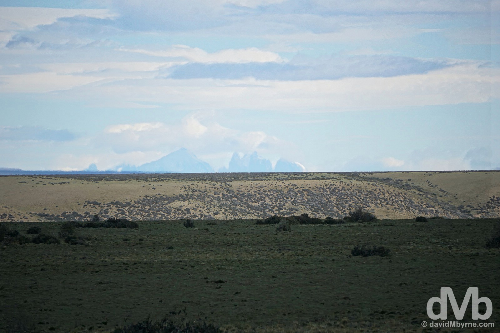
11:17 || This is a distant, very distant, shot as seen from Ruta 5 of the distinctive peaks of the Paine Massif of Parque Nacional Torres del Paine across the border in Chile, probably some, I guesstimate, 80-100 kilometres as the crow flies from here. Chile’s most visited attraction & one of South Americas’s biggest draws, it’ll be a week or so before I get to explore the park myself. Needless to say I’ve never been to Torres del Paine but I’ve seen enough pictures over the years to instantly recognise the unmistakable jagged peaks of its Paine Massif, the centerpiece of the park, even from afar. According to my guidebook, ‘nothing can prepare you for your first sight of Parque Nacional Torres del Paine’. Well I certainly wasn’t expecting my first sighting of it to be from a bus crossing the southern Argentinian Patagonian steppe. El Calafate bound on Ruta 5 in Patagonia, southern Argentina. November 1, 2015.
11:29 || Back seat view on Ruta 5, Patagonia, southern Argentina. November 1, 2015.
12:30 || Almost there. The view from the back row of an almost empty bus 17 and a half hours in & some 30 minutes out of El Calafate. There are glaciers emanating in those hills, the reason I was looking forward to (finally) getting off this bus. Heading west on Ruta 5, Patagonia, southern Argentina. November 1, 2015.
Parque Nacional Los Glaciares || Glaciers & Peaks
There are glaciers in the El Calafate region, the only reason I’m here (& it’s the only reason most who come here do so). El Calafate itself is rather nondescript, not somewhere I’m going to warm to (I can tell that having only just arrived). It certainly doesn’t come across as the tourist magnet it is, the result of its proximity to the glaciers of the nearby Parque Nacional Los Glaciares, specifically Glaciar Perito Moreno, only South America’s most accessible river of ice & probably Argentina’s greatest natural wonder. I suspect I will warm to that. It’s next.
PATAGONIA - PARQUE NACIONAL LOS GLACIARES - INTRODUCTION
Date || November 5, 2015
Location || El Chalten, Santa Cruz, Argentina ()
Created in 1937 & granted UNESCO World Heritage status in 1981, Parque Nacional Los Glaciares is Argentina’s largest protected area, a massive chunk of magical wilderness shoved up against the Andes in Santa Cruz province in the Patagonian southwest of the country along the border with Chile.

The 60 metre-high snout of Glaciar Perito Moreno, the Canal de los Tempanos (Iceberg Channel) & boats on Lago Argentino as seen from the system of elevated walkways on Peninsula Magallanes of Parque Nacional Los Glaciares, southern Patagonia, Argentina. November 2, 2015.
Parque Nacional Los Glaciares – Glaciers & Trekking – South vs. North
Encompassing a range of contrasting environments in its 7,270 km² area, the park can lay claim to not one but two of Argentina’s (& Patagonia’s) star attractions: the glaciers of the park’s southern reaches, massive creeping rivers of ice snaking down from the gigantic Hielo Continental Sur (the Southern Patagonian Icecap), the world’s largest area of permanent ice outside of the poles; and world-class trekking in the midst of some of the most scenic mountainscapes on earth in the hiking paradise that is the Fitz Roy sector in the northern reaches of the park.
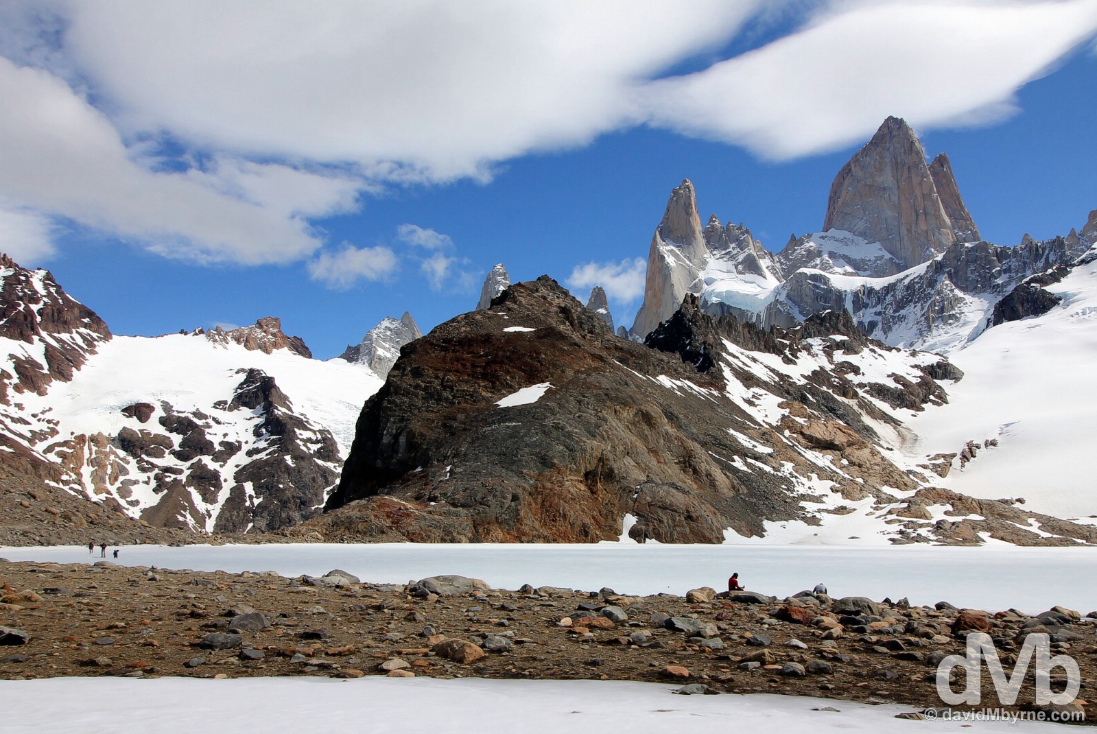
Resting by the frozen Laguna de los Tres in Parque Nacional Los Glaciares, southern Patagonia, Argentina. November 4, 2015.
– UNESCO commenting on Los Glaciares National Park
El Calafate & El Chalten || Access Towns
Over the past few days I’ve subjected myself to stays in both El Calafate & El Chalten, two towns on the fringes of the park some 220 kilometres apart that provide access to the aforementioned park highlights (& as far as I could tell that’s the only purpose they serve); El Calafate to the glaciers of the park’s south & El Chalten to the mountains & trekking of the park’s north. Not my favourite places on earth, I still managed a couple of nights each location, the bare minimum needed to get a sampling of the park’s numerous alpine wonders. First up was the glacial haven of the park’s south, some 80 kilometres from El Calafate.

Boating on Lago Argentino in view of the Glaciar Perito Moreno in Parque Nacional Los Glaciares, Patagonia, Argentina. November 2, 2015.
PATAGONIA - PARQUE NACIONAL LOS GLACIARES - GLACIERS
Glaciers || Glaciar Perito Moreno (Perito Moreno Glacier)
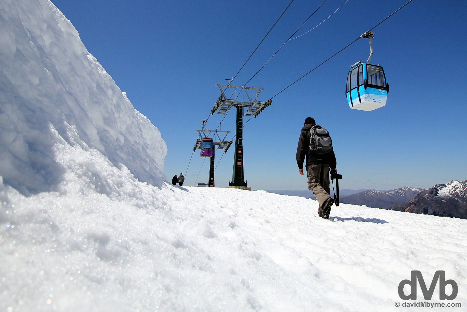
There are other glaciers in Parque Nacional Los Glaciares, 47 in total & all fed by the gigantic Hielo Continental Sur (the Southern Patagonian Icecap), the world’s third largest reserves of fresh water &, along with the smaller Northern Patagonian Icecap, the present-day remnant of the Patagonian Ice Sheet which covered all of this region during the last glacial period. But it’s the hulking mass of the legendary Glaciar Perito Moreno that gets the majority of the tourist love & attention primarily because it’s by far the most easily accessible of the park glaciers – it’s the only glacier in the park that can be accessed without the use of a boat, not to mention days of your time & wads of your money.

Accessibility assures Glaciar Perito Moreno is one of the major tourist attractions in southern Patagonia. A well-developed tourism infrastructure is in place on the tip of the park’s glacier-facing Peninsula Magallanes, an infrastructure well geared to accommodate the hordes that come to ogle at the glacier on a daily basis: there’s a large visitor centre; an overpriced café/restaurant; the usual array of souvenir shops; and an extensive system of elevated wooded walkways offering information on, and various views of, the glacier itself. Just be prepared to pay handsomely for the privilege of seeing this icy beast – getting yourself to the position of being able to view the glacier is an exercise in financial damage limitation, even using the so-called Argentine blue rate for purchases, so much so that I was somewhat surprised they don’t (yet) charge to use the onsite toilet in the visitors centre. Suffice to say, visiting & viewing the glacier is a wonderful experience; it’s a truly wondrous sight. It’s just a vastly overpriced one, so much so that you cant help but feel taken advantage of, something that may overshadow a visit. Unfortunately it did mine. Viewing the Glaciar Perito Moreno from the viewing platforms across the Canal de los Tempanos (Iceberg Channel) in Parque Nacional Los Glaciares, southern Patagonia, Argentina. November 2, 2015.
Overpricing/gouging aside, the sight of the Glaciar Perito Moreno, named after the 19th century Argentine explorer Francisco Moreno, is a memorable one. It’s not often you get to stand facing a giant mass of towering white & deep-blue ice, one measuring 5 kilometres across, 15 kilometres deep, & with a snout towering 60 metres above the waters of Lago Argentino (& for good measure there’s another 150 metres or so below the water surface). It’s so impressive that some go so far as to claim the glacier a natural wonder. I’ll leave the hyperbole to them.

All glaciers are basically a (very) slow moving jagged mass of gravity-propelled ice, a river of crevasses & jagged, spiky, leaning & unstable icy peaks. Needless to say Glaciar Perito Moreno is no exception, although this particular glacier glowed like I’ve never before seen a glacier glow (I could thank the clear blue skies for that). Marbled in places & deep blue in others – areas of pressurised de-oxygenated ice, the deeper the blue the more oxygen-starved the ice – I particularly loved the glowing blue of portions of the glacier innards, blues that seemed to get more neon-like as the afternoon shadows passed across portions of the ice wall; I spent many hours staring at this thing. The lighting may have (very subtly) changed but the scene never did, & nor did I ever get bored. Seeing vast chunks of ice drop off into the so-called Canal de los Tempanos (Iceberg Channel) fronting the glacier and bobbing away from the ice wall out into Lago Argentino, the largest lake solely in Argentina & South America’s third largest overall, was quite the spectacle, albeit a rare one. Much more common are the sounds – the thuds, the cracks, the creaks, and the grinding – of nature’s glacial soundtrack. At the Glaciar Perito Moreno in Parque Nacional Los Glaciares, southern Patagonia, Argentina. November 2, 2015.
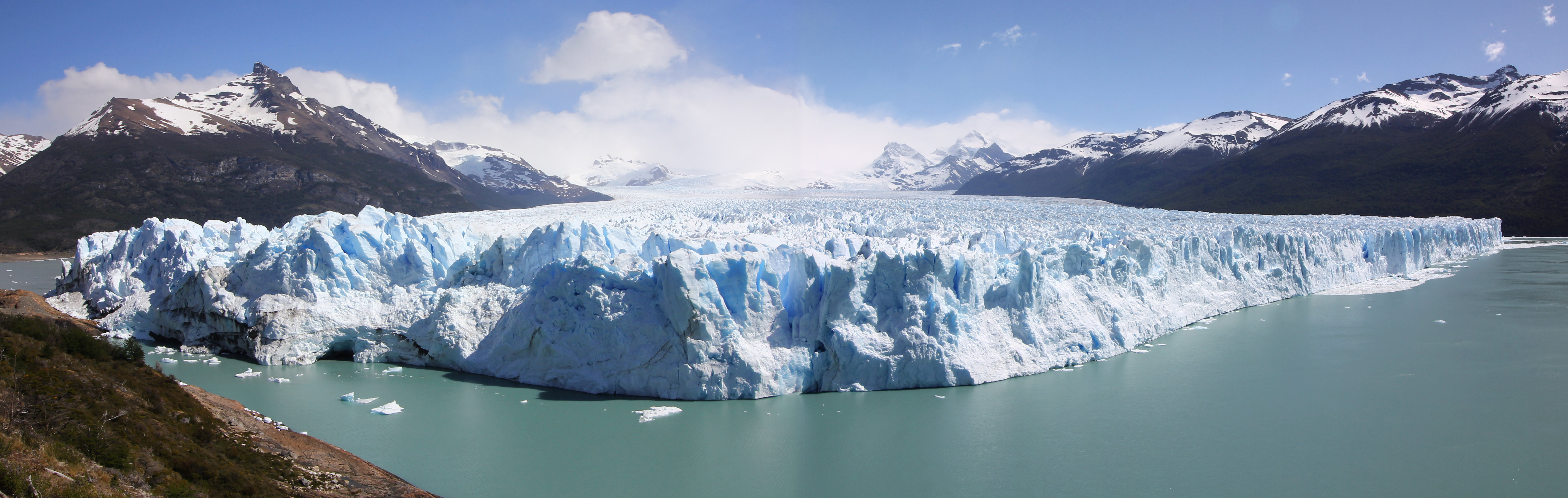
A dMb rarity, a panorama. This image shows the grin-like, 5 kilometre wide span of the glacier ice wall. Yes, left to right, or right to left, is 5 kilometres, give or take a few hundred metres. It also shows the galcier winding down some 15 kilometres from the heights of the Hielo Continental Sur (the Southern Patagonian Icecap), not to mention the 60 metre above water portion of the glaciers 210 metre-high snout. As impressive as those stats are, they don’t measure up to other glaciers elsewhere in the park – Glaciar Upsala stretches for 60 kilometres while Glaciar Spegazzini towers over 120 metres above the water, all of which pales in comparison to the 100 kilometre-wide, 400 kilometre-long & 2.5 kilometre-deep Lambert Glacier in East Antarctica, the world’s largest glacier. This picture also shows, to the left of frame, the edge of the park’s Peninsula Magallanes, location for the aforementioned visitor centre & system of walkways. Although classed as a stable glacier, meaning it’s neither advancing nor retreating, periodically pressures from ice weight push the glacier frontier to such an extent that it makes contact with the peninsula, effectively damning a section of Lago Argentino and leading to a massive rise in water levels. This eventually causes a spectacular rupture, billed as one of nature’s most awe-inspiring spectacles and one that last happened in 2012. At the Glaciar Perito Moreno in Parque Nacional Los Glaciares, southern Patagonia, Argentina. November 2, 2015.
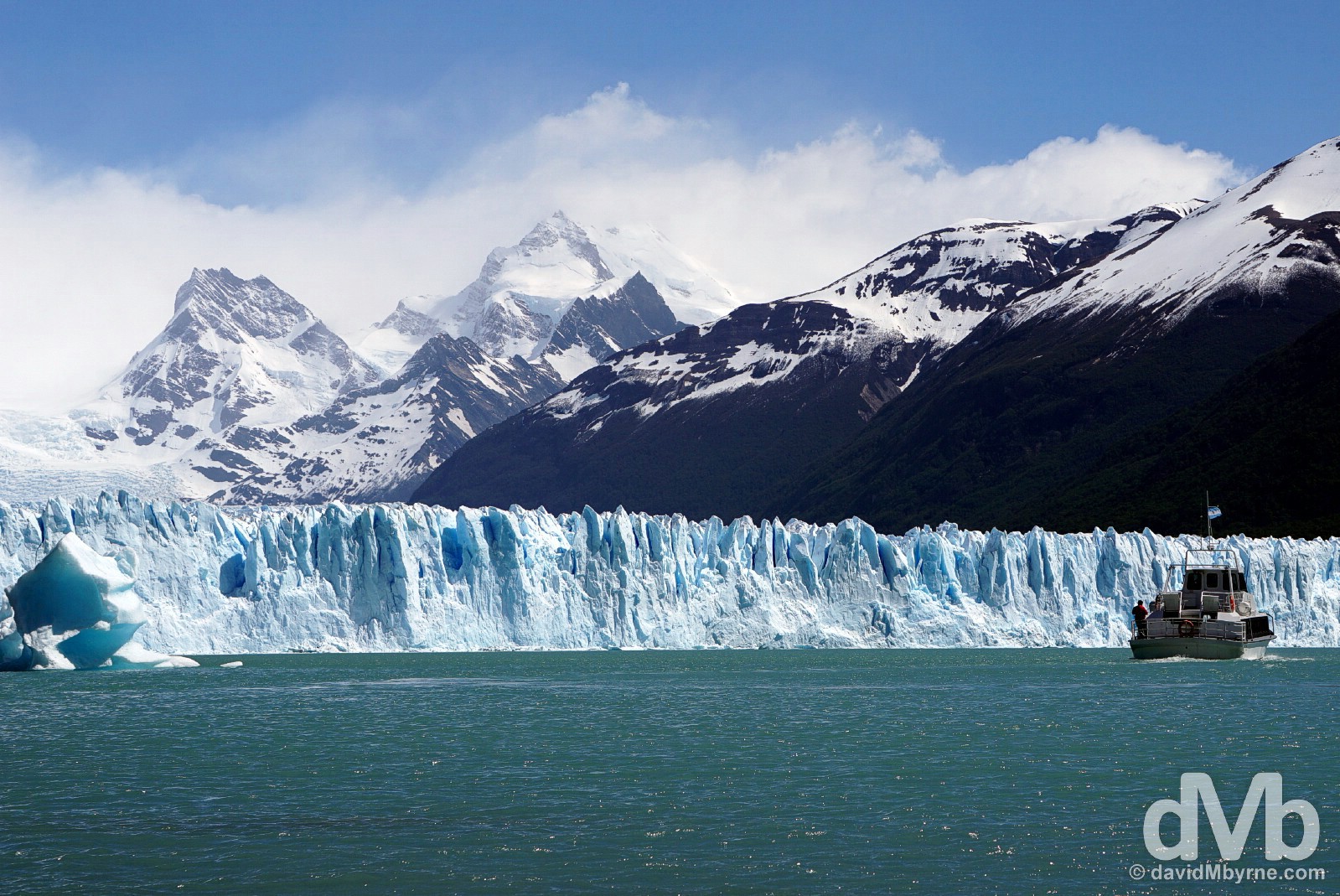
I took a 1-hour ‘scenic’ trip on this boat to get a different perspective on the glacier. I needn’t have bothered; the boat trip didn’t offer much & you actually get closer to the ice, a lot closer, via the walkways of the Peninsula Magallanes. If you want to get real close you can opt to go on a glacier hike (& I can only imagine how much you’d have to fork over for that), something I did on the Fox Glacier in New Zealand. Better still, save your money (that is if you’ve any left after getting yourself to the glacier in the first place) & bring a good zoom lens. Boating on Lago Argentino in view of Glaciar Perito Moreno in Parque Nacional Los Glaciares, southern Patagonia, Argentina. November 2, 2015.
Historical La Leona Rest Area
– A sign on Argentinean Patagonia’s Ruta 40 welcoming you to the Historical La Leona Rest Area
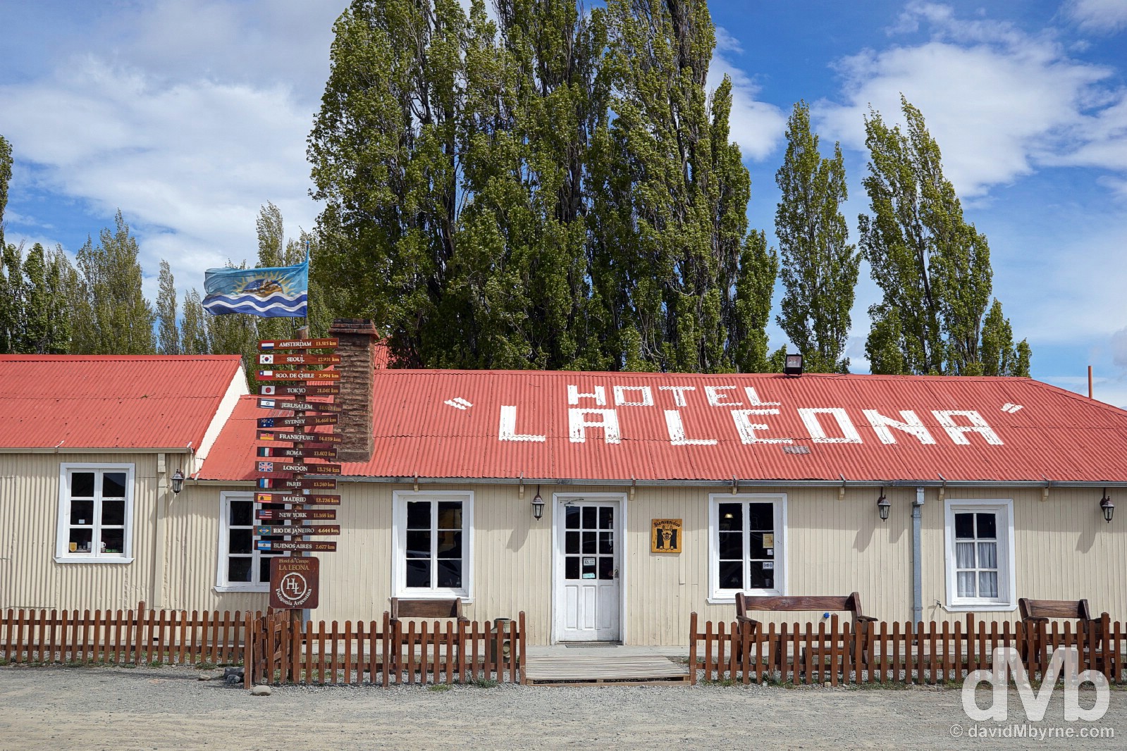
The small 4 bedroom Hotel La Leona is an historic wayside inn on Argentinean Patagonia’s Ruta 40 half way between the Parque Nacional Los Glaciares access towns of El Calafate and El Chalten. Despite heavy restoration and swarms of tourists (it seems every bus in either direction stops here), the place still oozes a true ye olde charm. Built in 1894 by a family of Danish immigrants, the Jensens, it was here, in 1877, that Francisco Moreno, the aforementioned 19th century Argentine explorer, was attacked and badly wounded by a female cougar, an incident that gave the hotel & the small river that runs through the area its name – la leona means lioness in Spanish. Bearing witness to a lot of regional history, the Leona’s main claim to fame is that in 1905 Robert LeRoy Parker & Harry Alonzo Longabaugh, a.k.a. Butch Cassidy and the Sundance Kid, stayed here for almost a month. They were, and after robbing a bank in Rio Gallegos, passing through the region en route to the Chilean border. Today the site (& hotel) is a convenient place to break the El Calafate to El Chalten journey and chances are if you’re on a bus you’ll be stopping here whether you want to or not. The historic Hotel La Leona, a popular stop on Argentinian Ruta 40 between El Calafate & El Chalten. Patagonia, Argentina. November 3, 2015
PATAGONIA - PARQUE NACIONAL LOS GLACIARES - HIKING
Hiking || Fitz Roy Sector
After visiting the park’s Glaciar Perito Moreno it was time to head north to the park’s so-called Fitz Roy sector, a region a world-class trekking among some of the most amazing mountain scenery on earth. And what a picturesque treat that was.
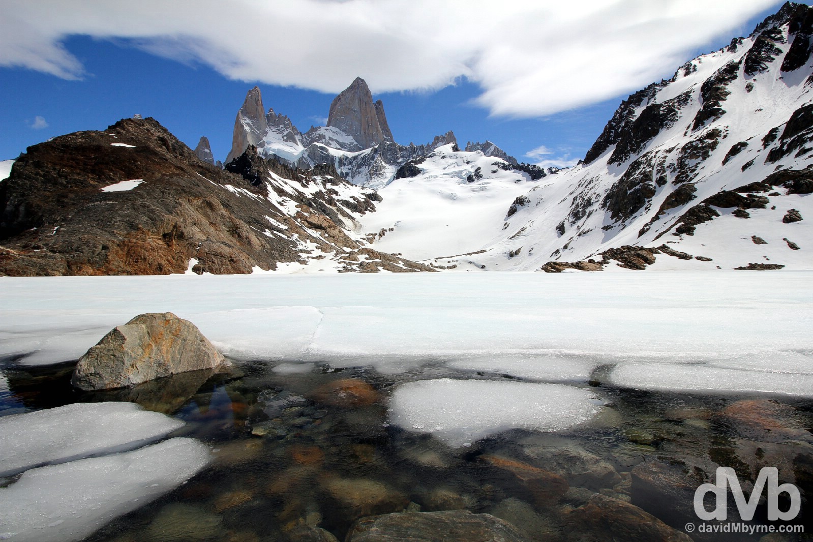
By the edge of Laguna de los Tres in Parque Nacional Los Glaciares, southern Patagonia, Argentina. November 4, 2015.
The Fitz Roy sector in the northern part of Parque Nacional Los Glaciares boasts not one but two breathtakingly beautiful mountain ranges of granite, needle-like peaks, the standouts of which are Cerro Torre & Monte Fitz Roy itself. Although some distance apart, when viewed from some angles they seem part of the same, awe-inspiring range.
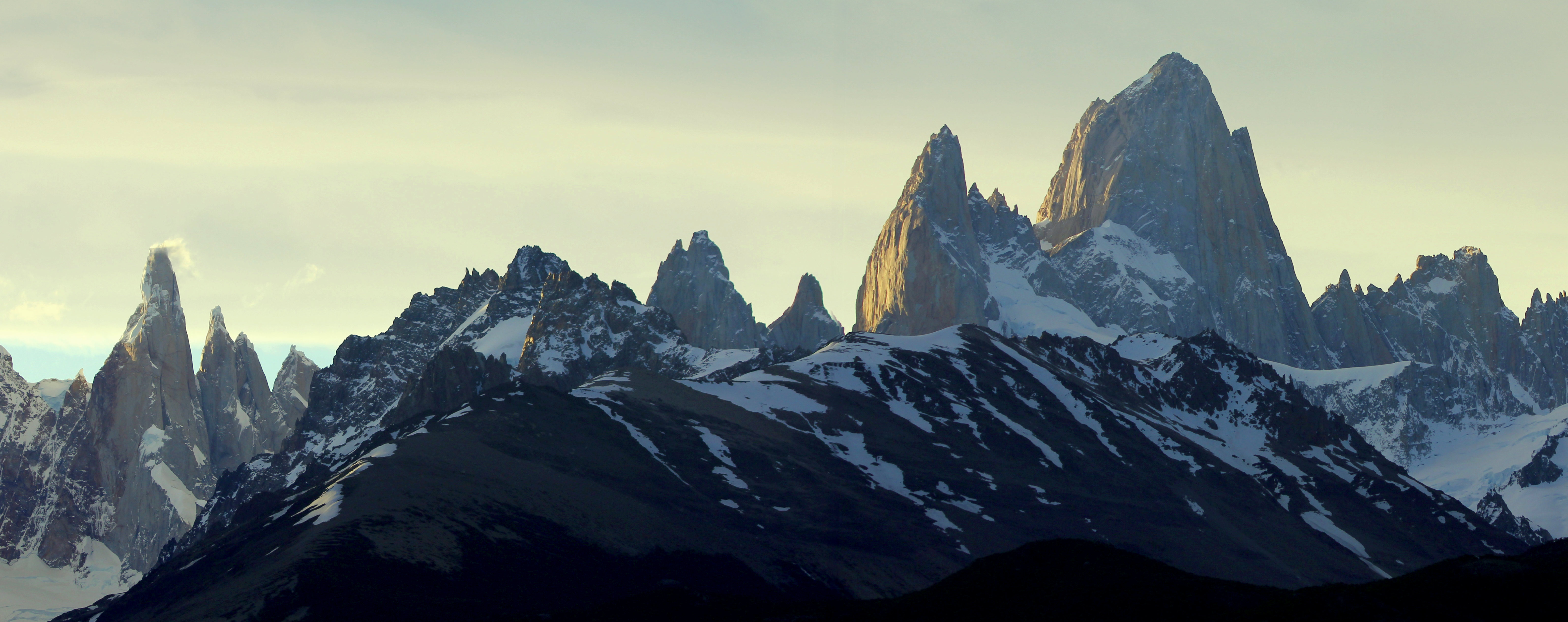
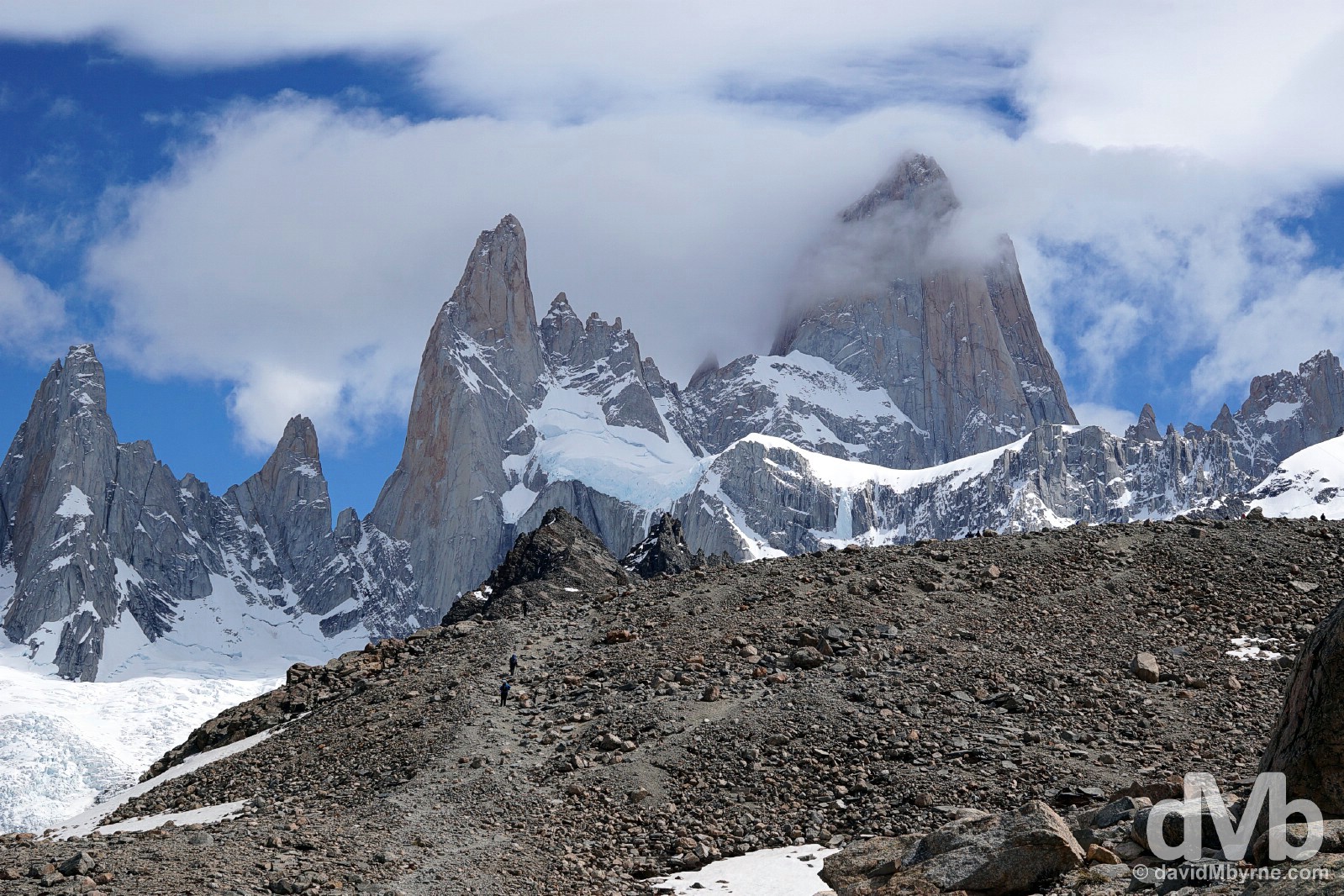
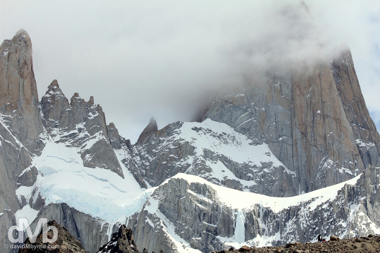
On my first evening in my present location of El Chalten, the Fitz Roy access town, I made my way the short distance outside of town to the Mirador de Los Condores (Condors Viewpoint) for a nice overview of the Fitz Roy sector peaks. The evening was cloudy & although I waited the clouds weren’t going anywhere; I got no presentable images of the vista in front of me… or so I thought. As I was despondently making my way back to El Chalten the clouds decided to break for a split second just before the sun disappeared below the horizon, briefly illuminating the western sides of the peaks in the process. It was glorious. This is a stitched panorama showing, among other peaks, the star attractions of, from left to right, the cloud-covered, needle-like Cerro Torre (3,120 metres) & the bulks of Cerro Poincenot (3,002 metres) & Monte Fitz Roy (3,375 metres), the tallest of the lot. The peaks of the Fitz Roy sector of Parque Nacional Los Glaciares as seen from outside the town of El Chalten, southern Patagonia, Argentina. November 4, 2015.
The peaks of the Glacier National Park’s Fitz Roy sector are famous for their slender, jagged, sky-piercing form, none more so than the peak of Cerro Torre.
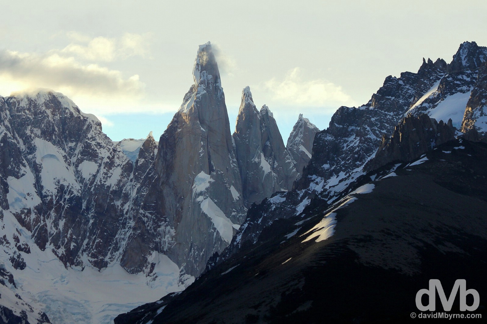
With some stiff competition, Cerro Torre, seen here with a wisp of cloud hanging around its summit, takes the award for having the park’s most needle-like form. Although a relatively modest 3,120 metres high, it’s the highest peak in a four mountain chain (the 3 other peaks all descend in height as seen here to the right of Cerro Torre itself). A combination of its slender form & an ever-present mushroom of rime ice at its very summit, a result of an ever-present, battering gale, meant it defied climbers until as recently as 1974, the year the first verified accent of the peak was made (another 1959 accent wasn’t verified). Even today, it remains one of the most difficult & least climbed peaks in the world. The last rays of the day on the distinctive, needle-like peak of Cerro Torre in Parque Nacional Los Glaciares, southern Patagonia, Argentina. November 3, 2015.
Laguna de los Tres Trail
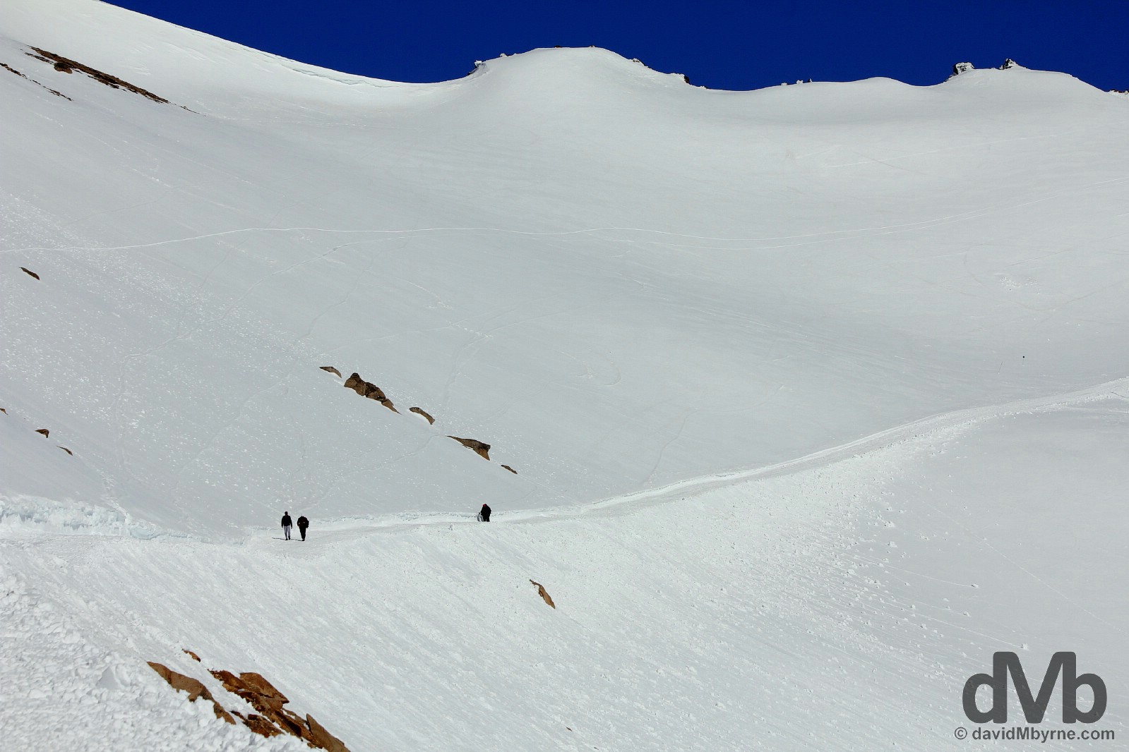
Views from afar are all well & good but I wanted to get a bit closer to the Fitz Roy peaks. I did so yesterday thanks to the 20 kilometre Laguna de los Tres trail, the most trekked trail in the park & one that rewards with stunning in-your-face views of Monte Fitz Roy & its neighbours. I found the trail, billed as hard/strenuous 8 hour excursion (I did it in 5), relatively easy going – save for the very last outward 1 kilometre up a steep scree slope, it’s mostly through flat woodland. It’s from a lookout between the 3 & 4 kilometre markers that you first get to view the peaks you’re walking towards, the light at the end of this particular 10 kilometre-long tunnel.
For the majority of the 10 kilometre outward trek, from about the 3.5 kilometre marker, the peaks seen here are ever-present, always in view & increasing in size as you approach them. This is a picture captured approaching the end of the outward trek, approaching the halfway point, a picture of trekkers tackling the last obstacle, the final moraine ridge from the top of which one is treated to what has to be one of the most awe-inspiring alpine settings on earth. Parque Nacional Los Glaciares, southern Patagonia, Argentina. November 3, 2015.
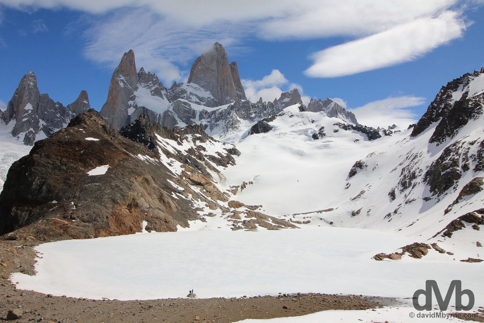
The view from the ridge at the end of the Laguna de los Tres trek is one of the frozen (in winter only) glacial Laguna de los Tres ringed by a crown of granite peaks, the most prominent of which is 3,375 metre-high Monte Fitz Roy (centre) & 3,002 metre-high Cerro Poincenot (left). Parque Nacional Los Glaciares, southern Patagonia, Argentina. November 4, 2015.
Look carefully and you’ll see, bottom right, hikers looking very small on the ridge facing Monte Fitz Roy. The peak was christened such in 1877 by Argentine explorer Francisco Moreno in honour of the Beagle who, with Charles Darwin aboard, had visited the region in 1834 and had viewed the Andes, albeit from a distance. First scaled in 1952, its 3,375 metre height wouldn’t reach half the height of some Himalayan peaks but, and thanks to its sheer granite faces, it still ranks as one of the world’s most technically difficult ascents. Fronting the massive granite peak of Monte Fitz Roy in Parque Nacional Los Glaciares, southern Patagonia, Argentina. November 4, 2015.

Twenty kilometres total – 10 out & 10 back. Kilometre markers on the Senda Fitz Roy (Fitz Roy Track) in the Fitz Roy sector of Parque Nacional Los Glaciares, southern Patagonia, Argentina. November 4, 2015.
El Chalten || The Lesser Of Two Evils
Access to the Fitz Roy sector of Parque Nacional Los Glaciares is via the town of El Chalten, the name given to present-day Monte Fitz Roy by the Tehuelche, the pre-European regional inhabitants who probably mistook Fitz Roy’s perennially cloud covered peak as volcanic activity (El Chalten means ‘smoking mountain’).
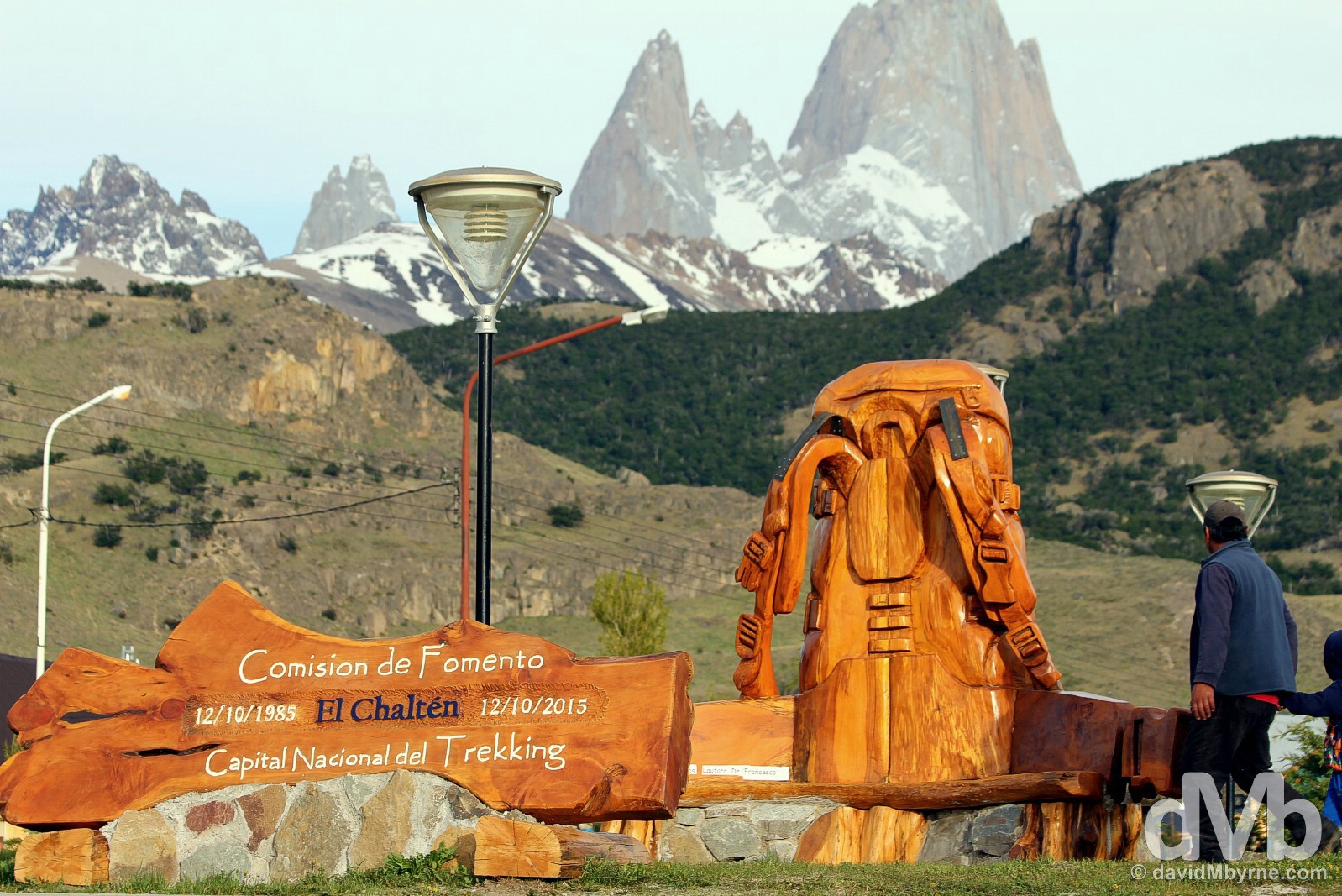
A frontier-esque & largely lifeless town at the confluence of two rivers, El Chalten looks & feels like something of an afterthought; it does little to hide the fact that its sole reason for being is to service the likes of me who come here to trek or climb its surrounds. The town bills itself as the trekking capital of Argentina, something it tries to validate by the presentation of a massive wooden backpack in the centre of the town’s Avenida M. M. Guemes. While there’s not a whole lot to do in the town itself and services scarce, it’s not a bad place to spend a few days and I found it more bearable than its larger southern counterpart of El Calafate, access town for the glaciers. Avenida M. M. Guemes, El Chalten, southern Patagonia, Argentina. November 5, 2015.
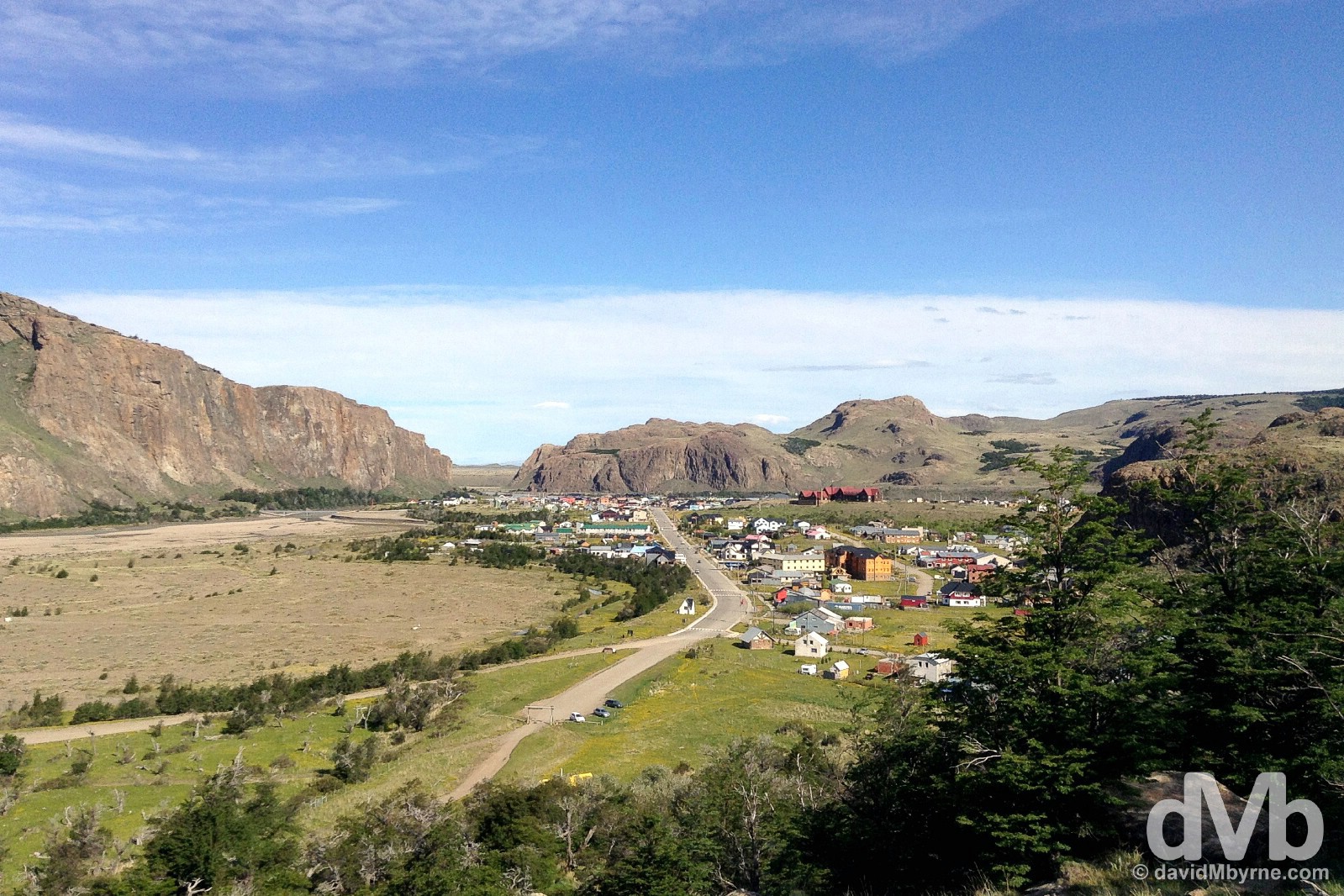
The town of El Chalten as seen from near the start of the Senda Fitz Roy (Fitz Roy Track) in the Fitz Roy sector of Parque Nacional Los Glaciares, southern Patagonia, Argentina. November 4, 2015.
TIERRA DEL FUEGO - USHUAIA
Ushuaia || Fin del Mundo
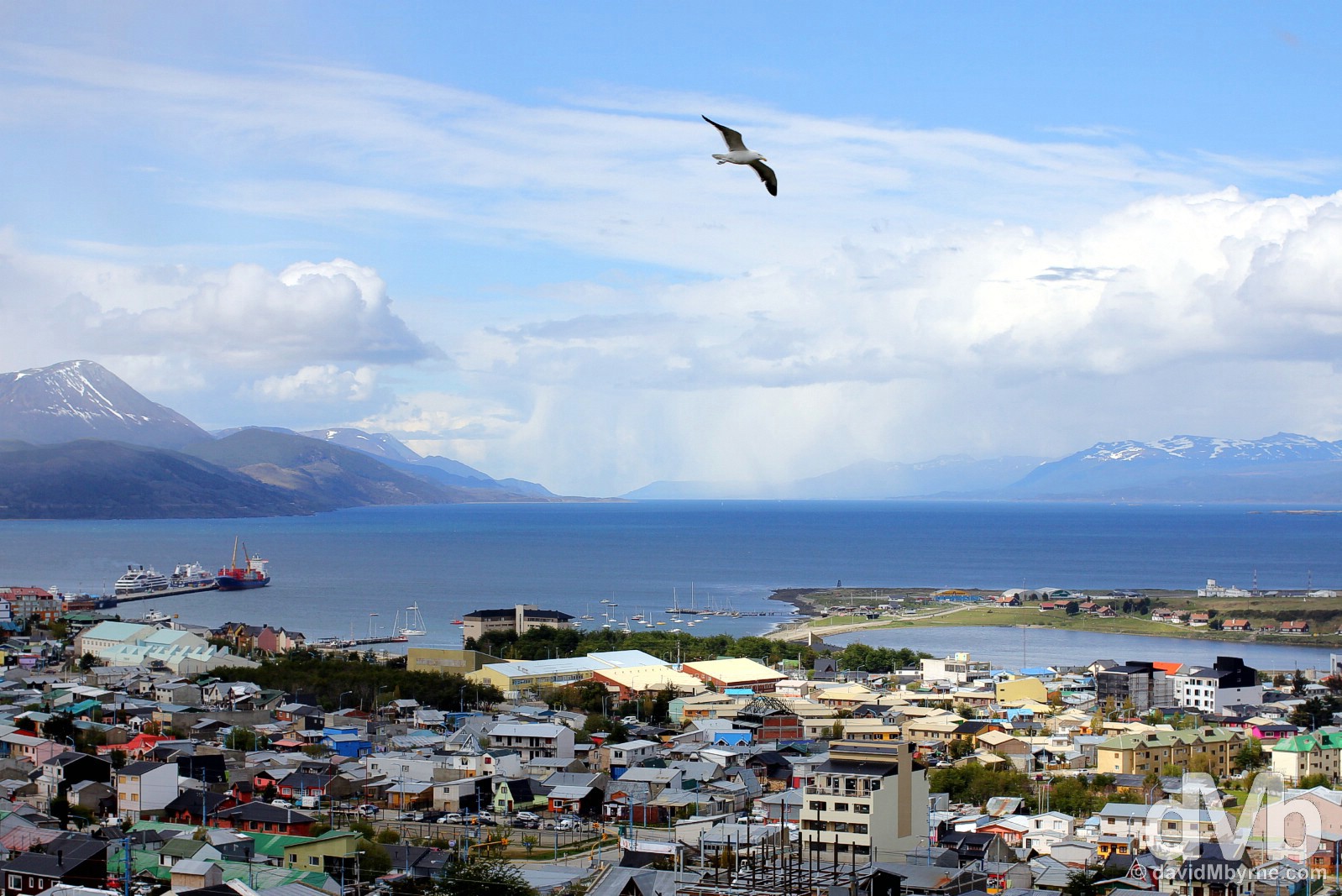
Established as a penal colony at the end of the 19th century, Ushuaia is by some way Tierra del Fuego’s largest settlement with a population of some 60,000. The town works hard at promoting the Fin Del Mundo, the World’s End, vibe a marking slogan that seems to work – travellers are drawn to “the world’s most southern city” ignoring the fact that Puerto Williams on Chilean Isla Navarino across the Beagle Channel from Ushuaia, and although with a population of less than 3000, also, & some say rightfully, claims to be “the world’s most southern city”.
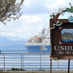
Ushuaia, the World’s End & the end of Argentinian Ruta (Route) 40, the country’s longest road. Tierra del Fuego, Argentina. November 14, 2015.
Most people fly into Ushuaia and head north overland. Others overland it here and fly north, as I eventually did. Very few overland in & out, the trip in enough to convince them that flying out is the better option. Yes the town’s setting is spectacular pushed as it is up on the Beagle Channel by jagged glacial peaks of the Sierra Venciguerra range; it boasts a pretty good if a little bit pricey museum, the Museo Maritimo; wildlife-spotting trips on the Beagle Channel are de rigueur; nearby Parque Nacional Tierra del Fuego will pass a day (or more); & there is a good traveller vibe in and around town. All that said, there is not a whole lot to do in Ushuaia & its well-marketed end of the world vibe will appease even the most passive of souls only for so long. Nine nights in total I spent here waiting… waiting… waiting to embark on a trip south to Antarctica, another reason travellers might find themselves in Ushuaia, and the primary reason I came here (although I’d have visited even if not embarking on a trip to the White Continent). And when it came to the time that I couldn’t wait any longer for that trip I decided to wait elsewhere, returning to Chilean Patagonia for a second stab at its famed Torres del Paine National Park subjecting myself to two more mammoth mundane bus trips in the process – I’d clearly reached the end of my tether waiting at the end of the world.
Soaring high over Ushuaia. This picture was captured from a vantage point overlooking the town (& the Beagle Channel) after returning from a hike to the Martial Glacier, another popular Ushuaia must-do. Ushuaia, Tierra del Fuego, Argentina. November 15, 2015.
More pictures from my time in Ushuaia.
-
- Sitting outside the port in Ushuaia, Tierra del Fuego, Argentina. November 14, 2015.
-
- Museo Maritimo (Maritime Museum) in Ushuaia, Tierra del Fuego, Argentina. November 14, 2015.
-

- An artists cabin in Ushuaia, Tierra del Fuego, Argentina. November 14, 2015.
-

- Part of the Antiguo Presidio (Old Prison) in Ushuaia, Tierra del Fuego, Argentina. November 14, 2015.
-

- A sign reading ‘The Mooring of English Pirates Ships Prohibited” outside the entrance to the port in Ushuaia, Tierra del Fuego, Argentina. November 13, 2015.
-

- Ushuaia, Tierra del Fuego, Argentina. November 15, 2015.
-

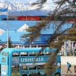
- San Martin, the main drag in Ushuaia, Tierra del Fuego, Argentina. November 15, 2015.
-
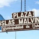
- Plaza Islas Malvinas in Ushuaia, Tierra del Fuego, Argentina. November 14, 2015.
-

- In the hills around Glaciar (glacier) Martial above Ushuaia, Tierra del Fuego, Argentina. November 15, 2015.
-
- Ushuaia, Tierra del Fuego, Argentina. November 15, 2015.
-

- Near the end of Ruta 3, the world’s southernmost highway, in Ushuaia, Tierra del Fuego, Argentina. November 13, 2015.
-
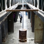
- Exploring the Antiguo Presidio (Old Prison) in Ushuaia, Tierra del Fuego, Argentina. November 14, 2015.
-
- Ushuaia, Fin del Mundo (the End of the World), Tierra del Fuego, Argentina. November 15, 2015.
-

- On the trail to Glaciar (glacier) Martial above Ushuaia, Tierra del Fuego, Argentina. November 15, 2015.
-
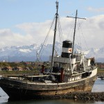
- The St Christopher tugboat in Ushuaia, Tierra del Fuego, Argentina. November 18, 2015.
-
- Plaza Islas Malvinas in Ushuaia, Tierra del Fuego, Argentina. November 13, 2015.
I enjoyed my time in Ushuaia. It just dragged on. And on. And on. And when it was time to eventually move on for good, and within hours of disembarking the boat from Antarctica, I was on a flight north to Buenos Aires, my final stop in Argentina.
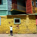
Buenos Aires
BA, The Capital, The Home Of Tango & South America's Most European of Cities
Image || Caminito, La Boca. December 6, 2015.
BUENOS AIRES
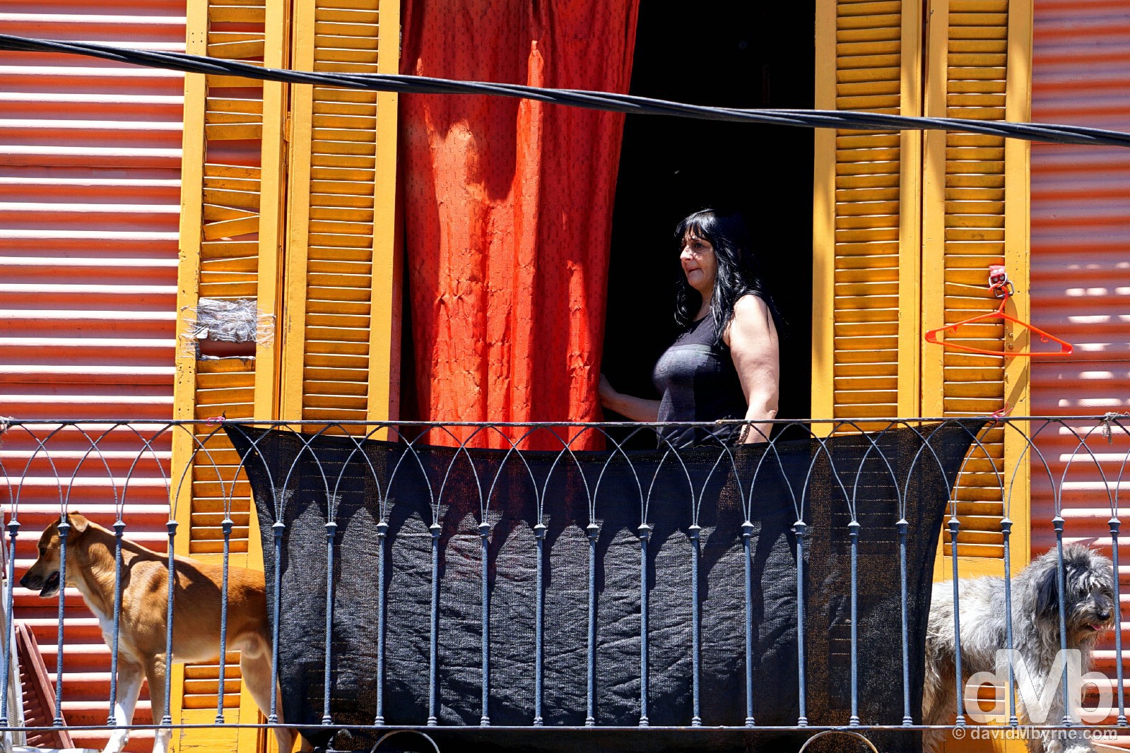
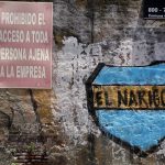
A residential balcony in the colourful La Boca neighbourhood of Buenos Aires, Argentina. December 6, 2015.
More pics from the city.
-
- Ministerio de Agroindustria, Av. Paseo Colon, Buenos Aires, Argentina. December 6, 2015.
-
- Garibaldi, La Boca, Buenos Aires, Argentina. December 6, 2015.
-

- Garibaldi, Caminito, La Boca, Buenos Aires, Argentina. December 6, 2015.
-
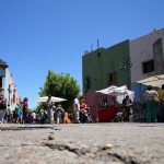
- San Telmo, Buenos Aires, Argentina. December 6, 2015.
-

- Dr. del Valle Iberlucea, La Boca, Buenos Aires, Argentina. December 6, 2015.
-
- Caminito, La Boca, Buenos Aires, Argentina. December 6, 2015.
-

- Boca Juniors jerseys for sale outside the Estadio Alberto J. Armando, aka La Bombonera, La Boca, Buenos Aires, Argentina. December 6, 2015.
-
- Buenos Aires, Argentina. December 6, 2015.
-
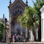
- La Recoleta Cemetery, Buenos Aires, Argentina. December 6, 2015.
-
- Caminito, La Boca, Buenos Aires, Argentina. December 6, 2015.
-

- Familia Duarte, the final resting place of Eva Perón, aka Evita, La Recoleta Cemetery, Buenos Aires, Argentina. December 6, 2015.
-
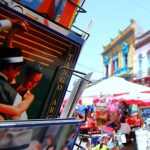
- Postcards for sale on Dr. del Valle Iberlucea, La Boca, Buenos Aires, Argentina. December 6, 2015.
-

- La Boca, Buenos Aires, Argentina. December 6, 2015.
-
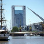
- Puerto Madero, Buenos Aires, Argentina. December 6, 2015.
-

- ‘Justicia por IARA!’ banners fronting the presidential palace La Casa Rosada off Plaza de Mayo in Buenos Aires, Argentina. December 6, 2015.
-
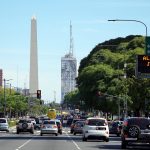
- Av. 9 de Julio, Buenos Aires, Argentina. December 6, 2015.