EPIC US ROAD TRIP 2016
DAYS 4-6 - THE DAKOTAS - NORTH & SOUTH DAKOTAImage || Crazy Horse Memorial, Black Hills, South Dakota.
Epic US Road Trip 2016 – The Dakotas
The Dakotas. North & South. Two states, threes days, over 1,000 miles.
NORTH DAKOTA – Straight, long & Legendary drives through nothing of note & to sights in need of an asterisk – is the out-of-the-way obelisk of dubious credibility in Rugby really ‘THE CENTER OF IT ALL!’ & did we really visit Sitting Bull’s grave in Fort Yates? Being asked if we were ‘lost’ & told to ‘slow down’ while leaving Bismarck.
SOUTH DAKOTA – Good times in the Badlands, the first national park of the road trip. Real life historic Deadwood, a slimmed-down Western Sin City. The Great Faces of Mount Rushmore National Memorial & the overambitious Crazy Horse Memorial in Great Places, the Black Hills, a stunning pine-clad anomaly rising from the otherwise flat plains.
The Dakotas. Two states, three days, lots of driving, & whole lot of fun.
– Wikipedia
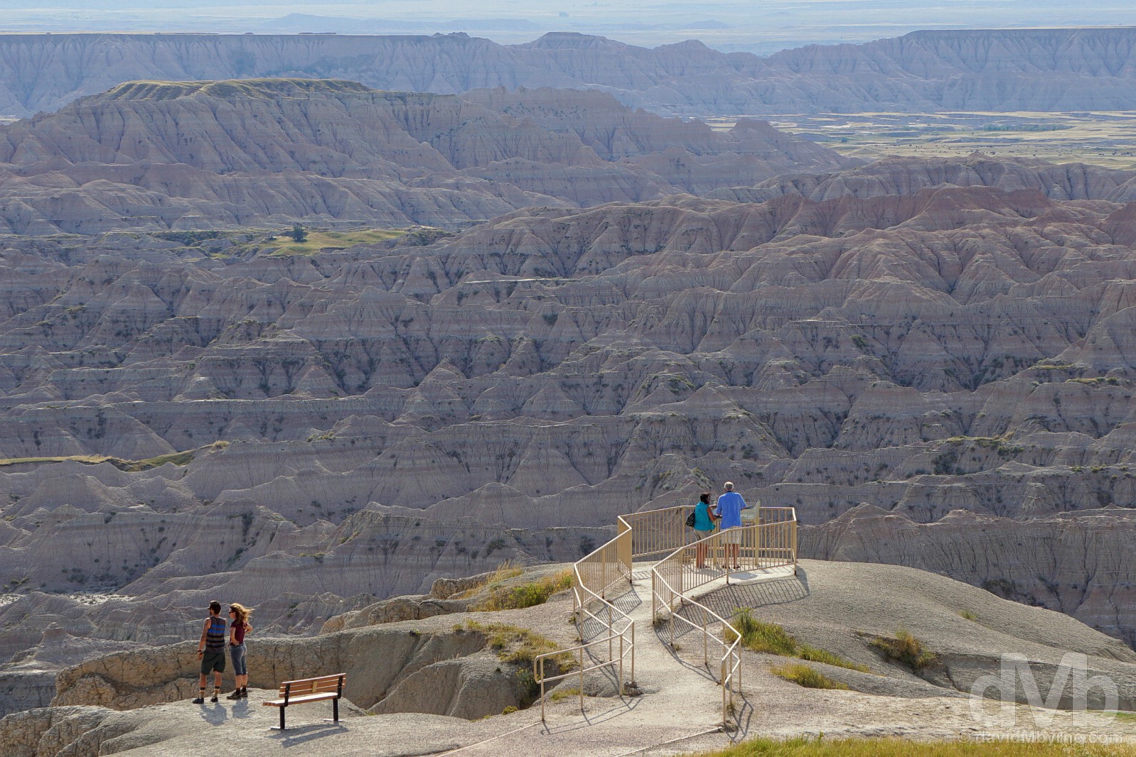
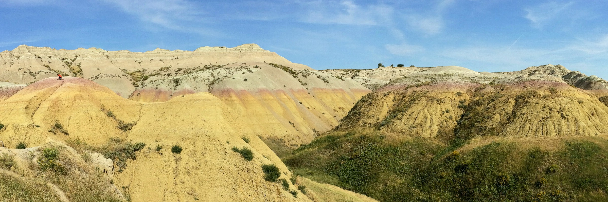
Overlooking the Badlands in Bandlands National Park, South Dakota. September 1, 2016.
Image || North Dakota bound on the US-2 in northwestern Minnesota.
“Move along. There’s nothing to see here. I guess US-2 may give you a more intimate view of nothing, but nothing is still nothing. Agriculture & grain fields, big rigs, looooong stretches of road and far-off horizons.”
Day 4 || August 31 2016
Route || Bemidji, Minnesota to Bismarck, North Dakota (via Grand Forks, Lakota, & Rugby, North Dakota)
Miles (Kilometres) Driven || 458 (737)
Posted From || Bismarck, North Dakota
Today’s Highlight || Nothingness.
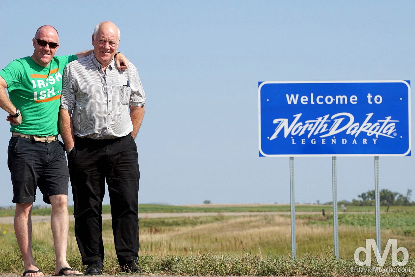
Before getting to the Dakotas, specifically North Dakota, we had of course to say goodbye to Minnesota. It was the perfect time to get the ‘Welcome to Minnesota’ picture. We hope to eventually become good enough at this to enable us to capture these pictures when actually entering a state.
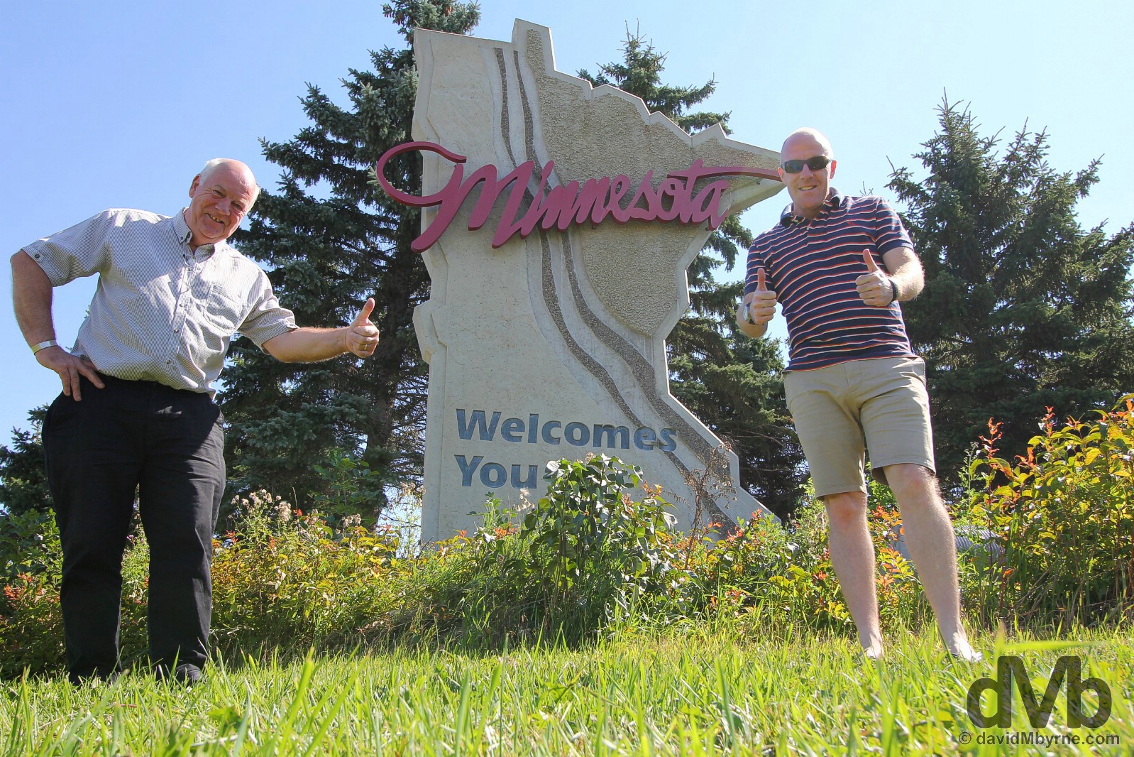
State sign #2 || Minnesota Welcomes You (both). It’s thumbs up at the Minnesota/North Dakota state line in Grand Forks, South Dakota. August 31, 2016.
State Nicknames – Peace Garden State; Roughrider State; Flickertail State. State Mottos – Liberty and Union; Now and Forever; One and Inseparable. Admitted To The Union – November 1889 (39th state). Population – 757,000 (4th least populous state). Area – 70,700 sq miles (19th largest state). Capital – Bismarck. National Parks – 1 (Theodore Roosevelt). National Scenic Byways/All-American Roads – 2/0. Famous For – The 1996 Oscar-winning Coen Brothers movie Fargo (which was actually set & filmed in neighbouring Minnesota); the location for the geographical centre of North America; big statues; nothingness & having no must-see attractions. State Highlights – That nothingness again. North Dakota Titbits – North Dakotans are a holy lot – the state has the most churches per capita & the highest percentage of church-going population of any US state; the state has a great number of Native Americans – the word “Dakota” is a corruption of a Sioux (Lakota) word meaning “allies” or “friends”. North Dakota is one of the least-visited states in the country. Yep, not too many people come up here to look at nothing.
North Dakota. State #3. Grand Forks, North Dakota. August 31, 2016.
Lonely Planet
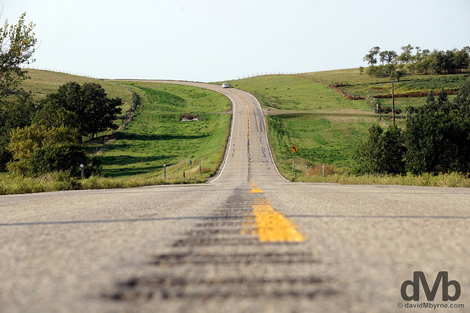
Lonely Planet recommends that if, like us, you’re embarking on a jaunt across North Dakota, something not a lot of people do, that you do so via the more northerly US-2, their reasoning being that it is a more ‘atmospheric’ choice than the arrow-straight Interstate 94, the state’s main east-to-west/west-to-east artery further south. We drove the US-2 today and if it’s indeed more atmospheric than the I-49 then, and for the very first time in my life, I feel the need to sympathise with a road.

Move along. There’s nothing to see here. I guess US-2 may give you a more intimate view of nothing, but nothing is still nothing. Agriculture & grain fields, big rigs, looooong stretches of road, and far-off horizons. That’s North Dakota. Heading west on US-2 in Lakota, North Dakota. August 31, 2016.
– NDTourism.com
Rugby. The Heart Of It All?
OK, so North Dakota isn’t blessed with attractions but it does boast a national park (Theodore Roosevelt National Park), not to mention the world’s largest bison, turtle & Holstein statues. We didn’t see any of those today meaning they don’t grace the 320 miles of US-2 and I-83 that we took to get from the Minnesota-North Dakota state line to Bismarck, the state capital with a population of 63,000. But we did see the obelisk marking the geographical centre of North America in the town of Rugby. Truth be told, it’s the reason we found ourselves in this sparsely populated part of the country. Yes, in a state short on attractions we went out of our way, and to within 45 miles of the Canadian border (a bit too close for comfort), to ogle over an obelisk of dubious credibility.

The 21-foot-tall obelisk off US-2 in Rugby, which a nearby sign boldly claims, in block capitals no less, is the ‘CENTER OF IT ALL!, marks the spot the town claims is the geographic centre of the North American continent. The town built the obelisk in 1932 and has even trademarked the title. But, and lest I be branded a killjoy, Rugby’s claim is a little off target; the town’s decades-long claim as the continental bull’s eye misses the mark by some miles, the correct spot a forlorn slough some 16 miles southwest of the town smack dab in the middle of nowhere; it’s in the middle of nowhere in the middle of nowhere, if you follow? The location celebrated today was calculated by an Edward M. Douglas in 1928 during much simpler times. Present-day technology has exposed his inaccuracies, not that the good folk of Rugby take much heed of that (and who can blame them if it works in attracting the likes of us?). Yep, close has been good enough for Rugby for the past 80 years just as it was for us today. It was bang on, actually. Rugby, North Dakota. August 31, 2016.
We’ll be arriving in South Dakota tomorrow. Historic Deadwood, the first national park of the trip (Badlands National Park), my birthday, and a rendezvous with a good friend, all on the one day, epic road trip day 5.
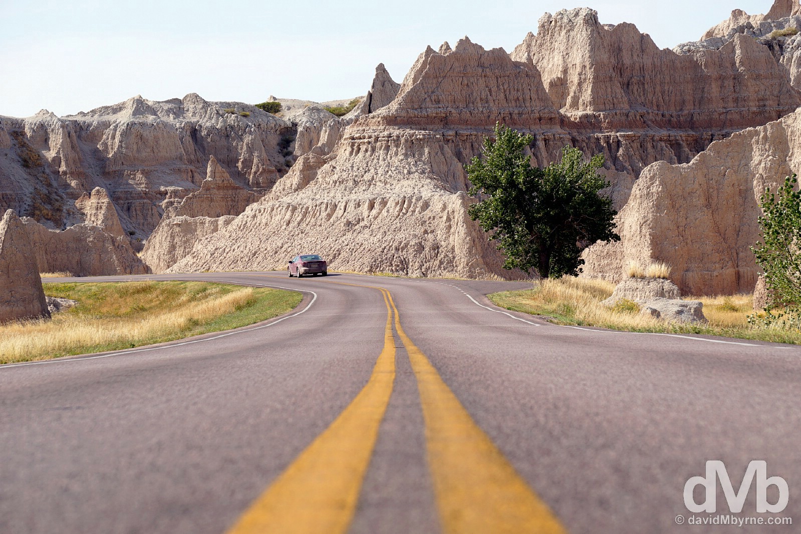
Image || Driving the Badlands Loop in Badlands National Park, South Dakota.
“… we took our time driving the 30-mile stretch of the park’s Highway 240, a.k.a. the Badlands Loop Road, skirting the so-called Badlands Wall. We spent our time driving through & around deep canyons, towering spires, precarious pinnacles, and flat-topped tables of the famous Badland buttes, stopping at many of the route’s nearly 30 scenic overlooks as we went.”
Day 5 || September 1 2016
Route || Bismarck, North Dakota to Deadwood, South Dakota (via Fort Yates, North Dakota & Badlands National Park, South Dakota)
Miles (Kilometres) Driven || 459 (739)
Posted From || Deadwood, South Dakota
Today’s Highlight || Arriving in Historic Deadwood.
“Slow down, they might not be so lenient next time.” So warned the North Dakota State Highway Patrol officer when handing me back my licence & sending us on our way. Eighty-two miles per hour he said he clocked me at heading south on US-6 outside Bismarck, North Dakota, earlier this morning. The speed limit, he reminded me, was 60 mph. Whoops. He was a nice guy, him & his partner warming to us once they determined that we were bona fide out-of-towners who were most definitely not carrying any firearms; the former was obvious, the latter needed to be ascertained. They even joked with us that we must have been ‘lost’ to find ourselves in this part of the country, in North Dakota. Ha. Good one, point taken and laugh shared. But no, we were not lost. We were just in a hurry, needing to cover a lot of ground on on this day, road trip day 5.
Heading south (having slowed down) off US-6 in Morton County, North Dakota, a very small section of the 459 miles of road we drove on road trip day 5. September 1, 2016.
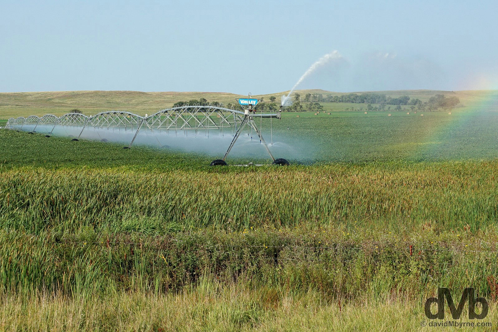
We’ve seen a lot of this over the last few days. Irrigation rigs spanning vast swaths of agriculture. This was one of the few actually in operation, meaning it was picture worthy. Located outside a forlorn settlement called Cannon Ball (population less than 1,000), somewhere we limped into in search of fuel, the abandoned-looking Cannon Ball Pit Stop coming to the rescue. Sioux County, North Dakota. September 1, 2016.
Fort Yates
Another location not on the original itinerary, we detoured off US-6 to the Native Indian town of Fort Yates. The present-day tribal headquarters of the Standing Rock Sioux Tribe, it’s also, on an unkempt finger of land overlooking the mighty Missouri River, the first burial site for one of Native America’s most revered figures, Tatanka Iyotake, a.k.a. Sitting Bull.
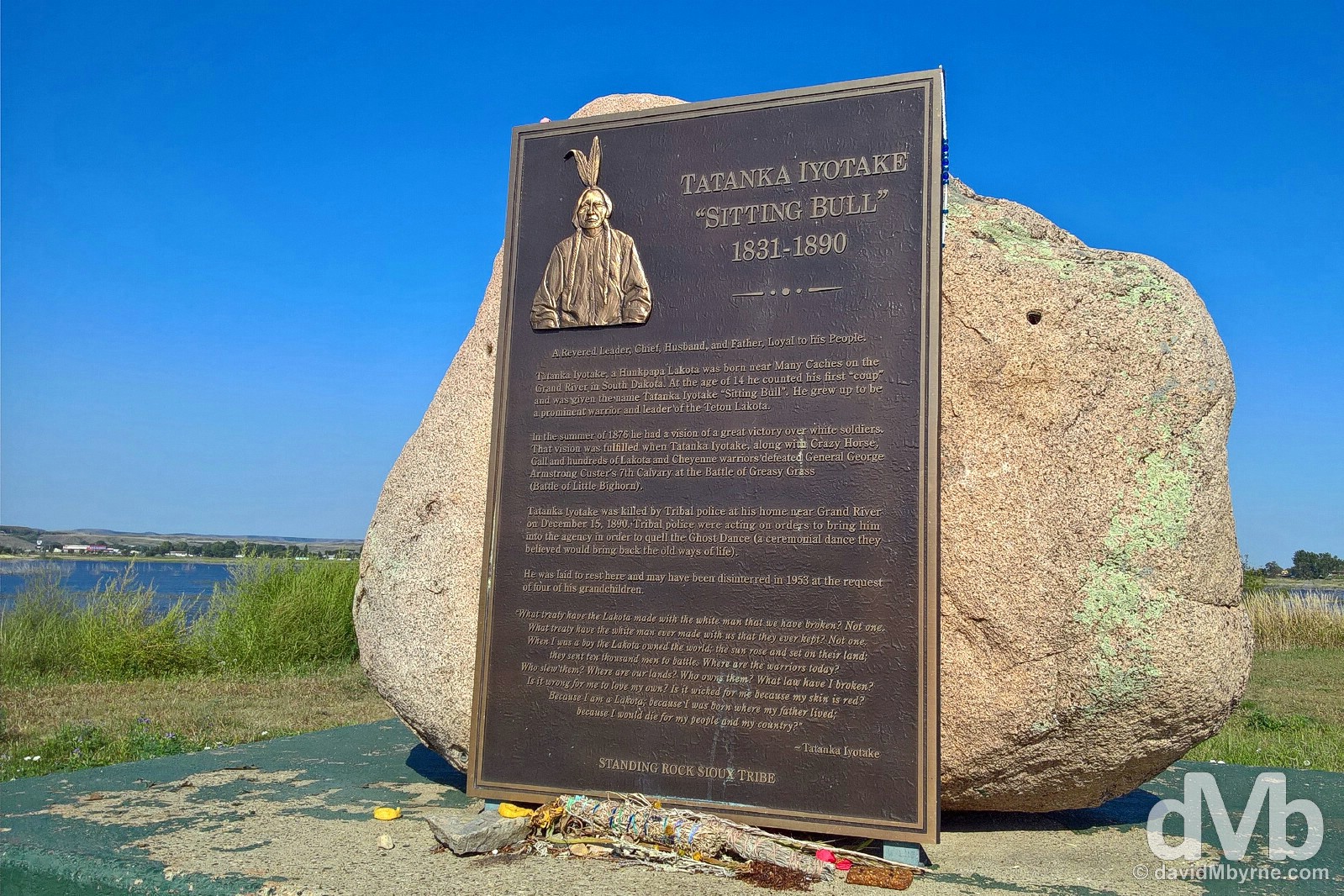
Sitting Bull was an important political & spiritual leader who was elected chief of the Teton Lakota people, an honour never before bestowed upon anyone. As warrior, statesman & leader, he held to the Lakota virtues of honesty, fortitude, bravery, generosity and wisdom throughout his life and fought tirelessly to keep alive the traditional way of his people by unifying the Lakota & Cheyenne against white expansion into their homeland. He led several bands of warriors in defiance of the US Government’s attempts, as part of their failed Peace Policy of 1869, to ‘Christianise & civilise’ the nomadic, roaming Indians, most notably at the 1876 Battle of Little Bighorn, a victory he famously foresaw in a vision. Untrusting of the white man and opposing the reservation system made him deeply unpopular with the US Army, ultimately leading to his death at the hands of tribal police in December 1890. He was laid to rest here by the banks of the Missouri River in Fort Yates but may have been disinterred in 1953 at the request of his grandchildren and reburied near his birthplace 50 miles south in Mobridge, South Dakota, somewhere that also, like here, claims to be his final resting spot (so which is it?). Fort Yates, North Dakota. September 1, 2016.
– Inscription at the base of the Tatanka Iyotake, a.k.a. Sitting Bull, Memorial in Forth Yates, North Dakota
Crossing The Line
Continuing south, next up was the North Dakota-South Dakota state line.
State sign #3 || Hello North Dakota. Actually, goodbye North Dakota. On the North Dakota/South Dakota state line in Corson County, North Dakota. September 1, 2016.
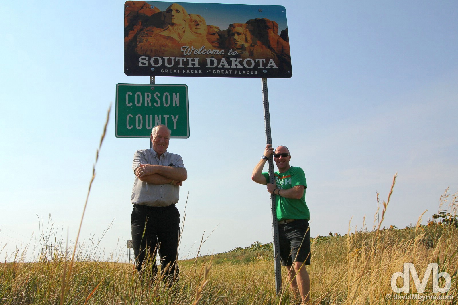
State sign #4 || On the opposite side of the road and it was hello to South Dakota, just like that. On the South Dakota/North Dakota state line in Corson County, South Dakota. September 1, 2016.
State Nickname – The Mount Rushmore State. State Motto – Under God, the People Rule. Admitted To The Union – November 1889 (40th state). Population – 860,000 (5th least populous state). Area – 77,100 sq miles (17th largest state). Capital – Pierre. National Parks – 2 (Badlands & Wind Cave). National Scenic Byways/All-American Roads – 2/0. Famous For – Gold Rush fever; Native American history; HBO’s loosely historical series Deadwood. State Highlights – The scenery, pioneering gold rush towns & monumental iconic sculptures (Mount Rushmore & Crazy Horse Memorial) of the Black Hills. South Dakota Titbits – The Dakotas are named after the Lakota and Dakota Sioux Native American tribes who comprise a significant portion of the population and historically dominated the entire territory; the state is one of only two of the 48 contiguous states without a passenger rail service; has the lowest per capita total state tax rate in the US; it has the highest number of schools per capita in the country.
South Dakota. State #4. Black Hills, South Dakota. September 2, 2016.
It was mid-afternoon when we arrived at the outskirts of Badlands National Park, the first National Park of the road trip. Located in southwestern corner of the largely flat & mundane state, the Badlands & the nearby pine-covered Black Hills, the latter clearly visible 70 miles to the west when approaching the Badlands, offer up a welcome reprieve from the endless rolling prairies, two geographical anomalies that are the undisputed highlights of any trip to South Dakota. ‘Great Faces. Great Places’ is the South Dakota state slogan and it was the Badlands that were to be the first of the great places we were to visit.
Driving a portion of the Badlands Loop in Badlands National Park, South Dakota. September 1, 2016.
– Freeman Tilden (1883-1980), Conservation Writer, commenting on South Dakota’s Badlands
Badlands National Park
Size: 242,756 acres/982 km². Founded: 1935, as a National Monument. 1978, as a National Park. Annual Visitors: 990,000.
Badlands are good for movies, and the land here is sheer drama. This park provided the asteroid surface for “Armageddon,” and scenes from “Dances With Wolves” were filmed here.
Visitors aim their own cameras at the same austere beauty, which includes buttes (isolated steep hills), canyons, pinnacles, spires and prairie. “The Badlands are cut from deep alluvial and volcanic ash deposits that have been sculptured and carved into fantastic forms by the continuous action of wind and water,” the editors of Consumer Guide explain at adventure.howstuffworks.com. That sculpting began 80 million years ago.
The resulting view — 75 miles east of Rapid City Regional Airport and 90 minutes from Mount Rushmore — can be seen via hiking, backpacking, camping or driving the Badlands Loop.
– Architect Frank Lloyd Wright, in a 1935 letter to the editor of the Evening Huronite
Animal inhabitants roaming the landscape include bison, bobcats, badgers and butterflies. Of the estimated 14,500 butterfly species in the world, the Park Service says 69 have been documented in Badlands, where wildflowers support them. The butterflies include the distinctive two-tailed swallowtail, whose wingspan reaches five inches.
The park’s Stronghold District, also known as the South Unit, is composed of lands on the Pine Ridge Indian Reservation owned by the Oglala Sioux Tribe. The 133,300 acres of the Stronghold District were added to Badlands National Monument in 1976, before the monument became a park in 1978. The land is full of history. And that story is memorialized, in part, at the nearby site of the massacre at Wounded Knee.
From The Washington Post – The Essential guide to all 59 U.S. national parks.
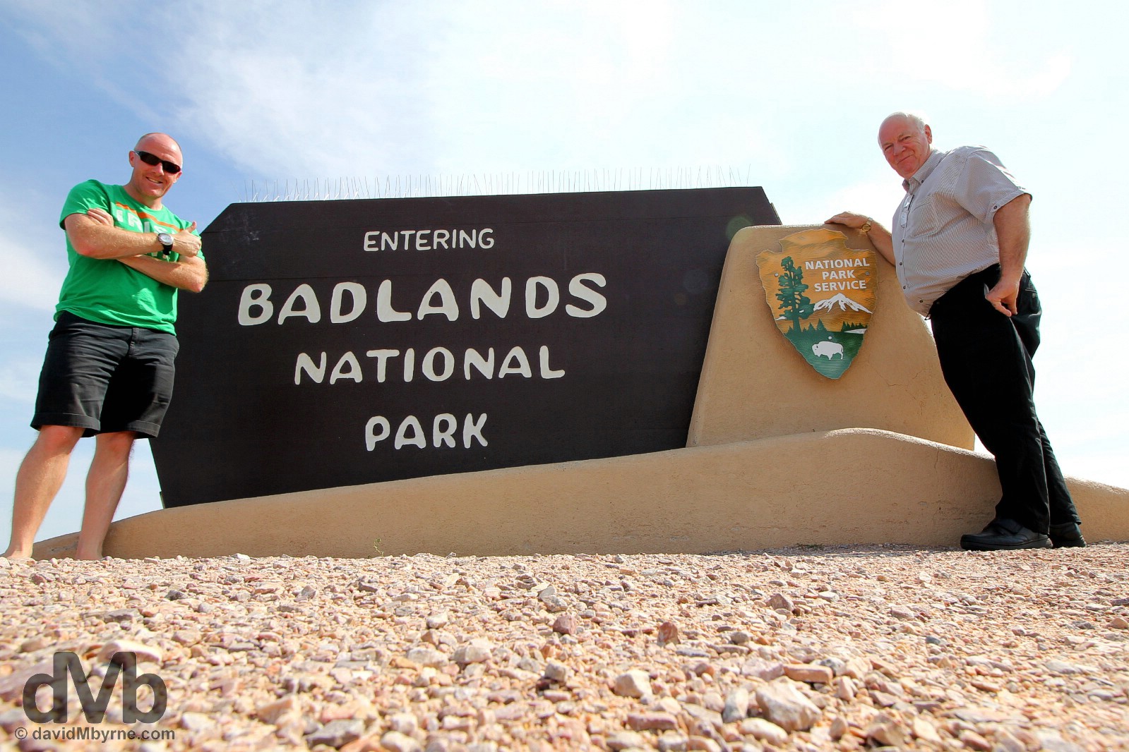
National Park #1 || At the Northeast Entrance to Badlands National Park, South Dakota. September 1, 2016.
Native American Lakota were the first to call it mako sica, meaning ‘bad lands’, a region of unique rugged beauty that has been drawing visitors from around the world for well over a century. It drew us, too, and we took our time driving the 30-mile stretch of the park’s Highway 240, a.k.a. the Badlands Loop Road, skirting the so-called Badlands Wall. We spent our time driving through & around deep canyons, towering spires, precarious pinnacles, and flat-topped tables of the famous Badland buttes, stopping at many of the route’s nearly 30 scenic overlooks as we went.

A road loved by motorcyclists, of which there are many in this part of the world, and immortalised in many a video game, the unique formations encountered along the Badlands Loop Road vividly illustrate how this land was formed, the result of two basic geological process: deposition and erosion. Deposition of rock layers stretches back some 75 million years when soft, sedimentary rocks cemented into solid layer form, the evidence of which can clearly be seen in this picture. Erosion, which only started some 500,000 years ago, saw water cutting through the rock layers, carving fantastic shapes into what was once a flat floodplain. Erosion is ongoing; each time it rains more sediment is lost from Badland buttes, so much so that it is estimated the buttes erode almost 8 mm (one-third of an inch) a year. All this means that the present-day rock formations of the Badlands will be gone in another 500,000 years or so, the park no more. Glad we got here when we did. Driving a portion of the Badlands Loop in Badlands National Park, South Dakota. September 1, 2016.
Among the towering & eroding rock formations of Badlands National Park, South Dakota. September 1, 2016.
Badlands National Park, South Dakota. September 1, 2016.
Deadwood in The Black Hills of South Dakota.
– Al Swearengen, HBO’s Deadwood, Season 2, Episode 1 “A lie agreed upon”
Deadwood
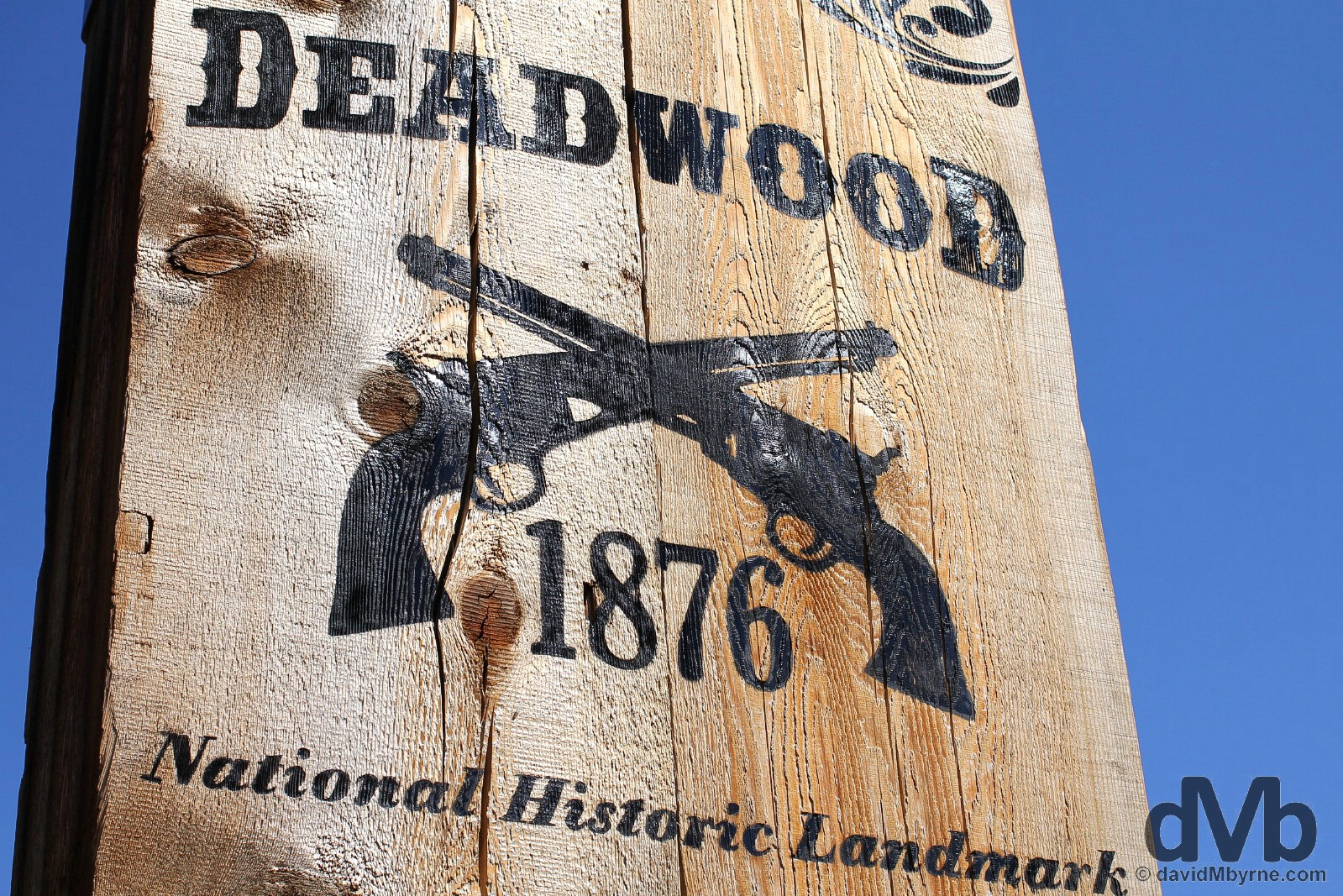
A long day on the road ended when we rolled into Deadwood. I was like a kid in a candy store. It was the perfect birthday present. A town steeped in history & lore, in the 1870s Deadwood Gulch was the site of the last big frontier gold rush in North America. Fuelled by gold and greed, Deadwood, named after the dead trees found in its gulch, began in 1876 as a lawless mining camp on demarked sacred Sioux Indian territory, one full of rough-and-tumble get-rich prospectors and an anything-goes Main Street business district that comprised largely of saloons, dance halls, card parlors and bodacious bordellos. This was the wild Wild West.
– TravelSouthDakota.com
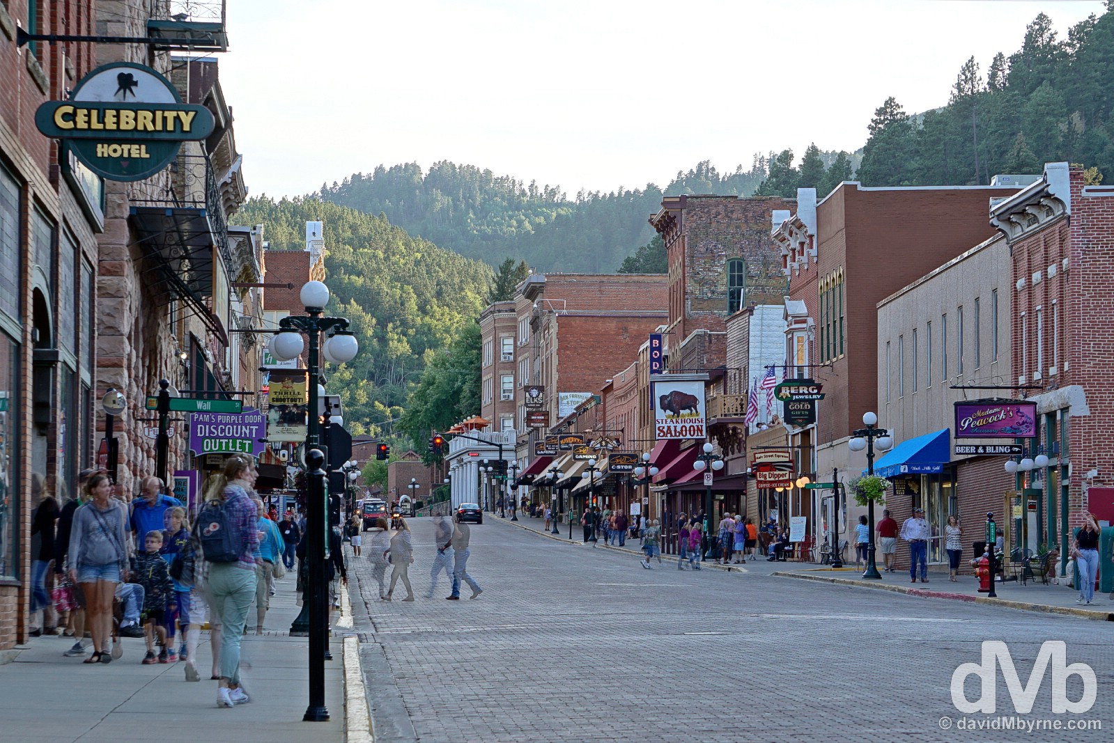
Present-day Deadwood is centred on its largely fabricated but still captivating Main Street, designated a National Historic Landmark in 1961. While shamelessly Disneyesque (casinos, happy hour saloons, & an abundance of tacky tourist tat give it something of a superficial Las Vegas feel), the combination of the town’s location and the sense of the pioneering Wild West that the street both preserves & plays upon is addictive, the history it milks both undeniable & fascinating. Nothing remains of 1876 Deadwood, the complete & original business district of main street having being destroyed in a fire in 1879. Much of the original business owners rebuilt, as they did after another fire in 1884, some also relocating. Floods also blighted the early settlement; present-day main street is higher than the original main street would have been. This was my first shot of Deadwood having just arrived in town. The town’s gulch location means dusk isn’t the best time for Historic Main Street Deadwood photography (the sun vacates the street early in the day but lingers long in the surrounding pine-covered hills) but I couldn’t resist, and no doubt I’ll see the historic Main Street in better light over the coming days. Historic main street Deadwood in the Black Hills of South Dakota. September 1, 2016.
HBO’s Deadwood
The loosely historical series Deadwood, which charts the settlement’s growth from illegal camp to bona fide town & incorporates themes ranging from the formation of communities to western capitalism, first aired on the American premium cable network HBO in March 2004 (I discovered it in 2011 & have rewatched it many times since). Over the course of 3 all-too-brief seasons, the show earned widespread acclaim. Regarded by many, me included, as the best TV show ever committed to film, it featured intricate plots, complex characters, and a labyrinthine, Shakespearean sense of dialogue that hadn’t been seen on TV before or since. Some decried the show’s language & liberal use of profanity – the ‘f’ word is uttered 43 times in the first hour of the very first episode and someone calculated that throughout the 36-episode run it is uttered on average of 1.56 times per minute of footage. Others, again me included, found the language beautiful, funny, profound and profane, adding to the lore of present-day Deadwood and to the desire to see it for myself; Deadwood was top of the list of locations to visit when planning this road trip and so arriving here this evening was something all-too special.
– E.B. Farnum, HBO’s Deadwood, season 1

Visiting Deadwood sees you walking in the footsteps of historic Old West legends like Wild Bill Hickok, Calamity Jane, Al Swearengen, and Seth Bullock: it sees you downing beers while watching a reenactment of Wild Bill’s assassination in Old Style Saloon Number 10; it sees you laying your head in the Bullock Hotel; and it sees you having a ham-heavy Mr. Woo’s Eyeopener breakfast in the parlor of the present-day Gem Saloon. The Historic Main Street boasts two Saloon Number 10 establishments. One is the aforementioned Old Style Saloon Number 10, a wagon wheel-heavy Wild West theme bar with sawdust floors, cheap beer, & guaranteed next-day hangovers. The other Saloon Number 10, seen here, is the location for the original Nuttall and Mann’s Saloon, nicknamed the Number 10 saloon as it was the 10th claim to be registered in upstart Deadwood. Rebuilt twice after the fires of 1879 and 1884, today the site of the original Saloon Number 10 is less bar more gift shop cum tourist attraction, one offering tours to a roped off section at the rear where Wild Bill famously played his last poker hand of a pair of black aces and a pair of black eights, forever since known as the Dead man’s hand. On Historic Main Street Deadwood, Black Hills, South Dakota. September 1, 2016.
– Al Swearengen, HBO’s Deadwood
Image || Mount Rushmore National Memorial, Black Hills, South Dakota.
“… the stony-faced foursome really is quite the sight, even if it is unfinished – the original design, scaled down due to lack of funding as a result of World War II, called for each president to be depicted from head to waist…”
Day 6 || September 2 2016
Route || The Black Hills – Mount Rushmore National Memorial, the Crazy Horse Memorial, & the Peter Norbeck National Scenic Byway
Miles (Kilometres) Driven || 167 (269)
Posted From || Deadwood, South Dakota
Today’s Highlight || The Needles Highway of the Black Hills Custer State Park.
It was a slow start to proceedings today, a late night last night necessitating a welcomed change of pace from previous days. We eventually got back to the itinerary, hitting US 385 south from Deadwood for an exploration of the historical carved monuments, dramatic peaks, valleys, meadows & dark stands of conifers that is South Dakota’s Black Hills.
Great Faces. Mount Rushmore National Memorial in the Black Hills of South Dakota. September 2, 2016.
The Black Hills – Treaties, Gold, Custer, Rushmore, Crazy Horse & Scenic Drives
The 13,000 km² Black Hills, so-called because of their dark, tree-covered appearance from a distance, are a small isolated mountain range rising from the plains of southwestern South Dakota and extending over the state line into Wyoming. This ‘Island in The Plains’ had always been Native Indian land (‘Black Hills’ is a translation of the Lakota Pahá Sápa) and considered sacred. However, it wasn’t until the 1868 Fort Laramie Treaty between the U.S. Government and the Lakota that this region of South Dakota was officially demarked Indian territory, and for eternity no less. Happy days, you’d think. The discovery of “gold in them thar hills” shortly thereafter changed things a tad – the treaty was to prove to be just the latest in a string of treaties broken by the white man when, in 1874, one Lt Col George Armstrong Custer led a gold-finding expedition encroaching on Indian territory. Custer’s announcement of gold triggered the Black Hills Gold Rush and while this was to mean riches for white settlers it equated to a fight for sacred lands for the Lakota. Miners & prospectors flooded in establishing illegal & lawless towns in the process, the most famous of which was Deadwood (founded 1876).
– Ta Sunke Witko (Crazy Horse)
Needless to say, with encroachment the Indians naturally got the hump & retaliated. Ultimately this was bad news for Custer as he was to famously meet his maker over the border in Montana at the hands of the Lakota leader Crazy Horse et al at the 1876 Battle of Little Bighorn, a.k.a. Custer’s Last Stand, the largest of the USA vs. Native American Indian Wars and the last major victory of the Plains Indians’ over the white invaders. The outcry from the Little Bighorn defeat saw Congress cutting off all rations to the Indians until they terminated hostilities and ceded the Black Hills back to the US; it was termed the “sell or starve” proviso by the Indians. Threatened with starvation the Indians had no choice but to comply, an 1877 amendment to the Indian Appropriations Act officially taking away Indian lands, including the Black Hills, and permanently established Indian reservations. The Indians never accepted the legitimacy of the transaction, never accepted monies awarded to them as compensation resulting from a 1980 Supreme Court ruling that the US had taken back the Black Hills without just compensation, and they continue to this day to insist on their right to occupy the land.
In the pine-scented Black Hills of South Dakota. September 2, 2016.
Today the Black Hills encompass the dramatic Black Hills National Forest and are a major tourist draw being home to, among others, South Dakota’s first & largest state park (Custer State Park), one of North America’s most scenic drives (the Peter Norbeck National Scenic Byway), and, of course, two historical & unfinished monuments carved right into towering Black Hills granite – Mount Rushmore National Memorial, the iconic depiction of 4 revered US presidents, and the Crazy Horse Memorial, a long-in-progress tribute to the aforementioned storied Native American tribal leader.
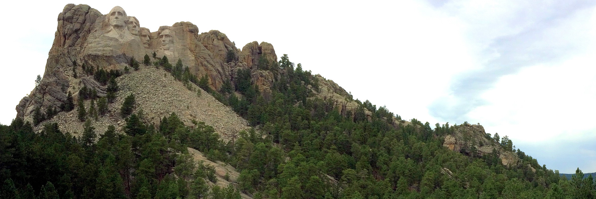
America’s so-called Shrine to Democracy, the iconic Mount Rushmore National Memorial, which attracts some 3 million visitors a year, is up there with the Statue of Liberty when it comes to instantly recgonisable American landmarks.
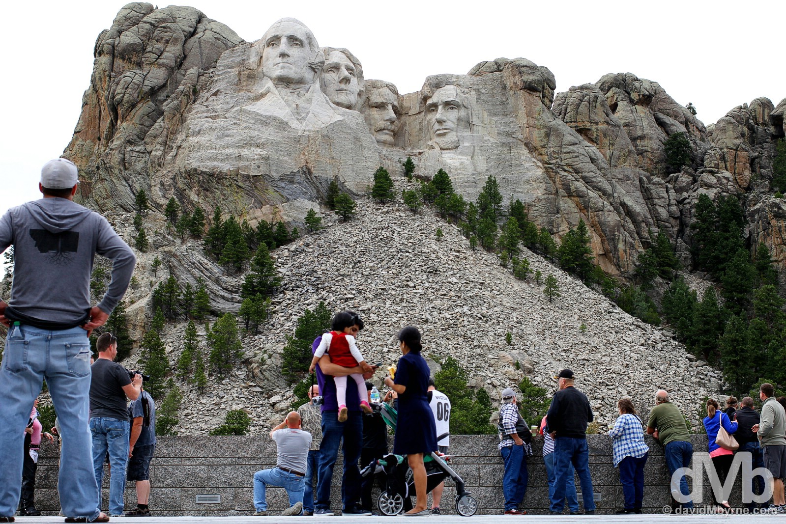
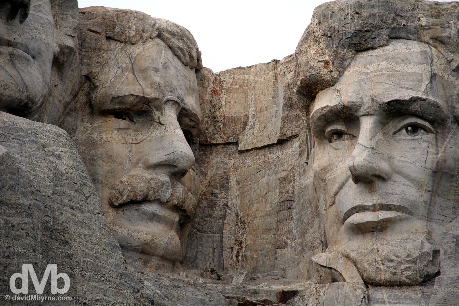
Carved between 1927 and 1941 into Black Hills granite by a 400+ strong team led by Danish-American sculptor Gutzon Borglum, the centrepiece of the 5.2 km² Mount Rushmore National Memorial famously features the 18-metre-high (60 ft) faces of four great American presidents who, it is said, represent the birth, growth, development and preservation of the country: (L-R) George Washington (1732–1799, 1st President (1789–97)); Thomas Jefferson (1743–1826, 3rd President (1801–09)); Theodore Roosevelt (1858-1919, 26th President (1901-09)); & Abraham Lincoln (1809–1865, 16th President (1861-65)). Viewed from the Grand View Terrace, accessed via the Avenue of Flags, a walkway of 56 waving flags representing all U.S. states and territories, the stony-faced foursome really is quite the sight, even if it is unfinished – the original design, scaled down due to lack of funding as a result of World War II, called for each president to be depicted from head to waist (work had clearly started on the carving of Washington’s upper torso by the time the project was shelved in October of 1941). At the Grand View Terrace of Mount Rushmore National Memorial, Black Hills, South Dakota. September 2, 2016.
– Gutzon Borglum, Mount Rushmore Sculptor, 1930
Mount Rushmore National Monument in the Black Hills, South Dakota. September 2, 2016.
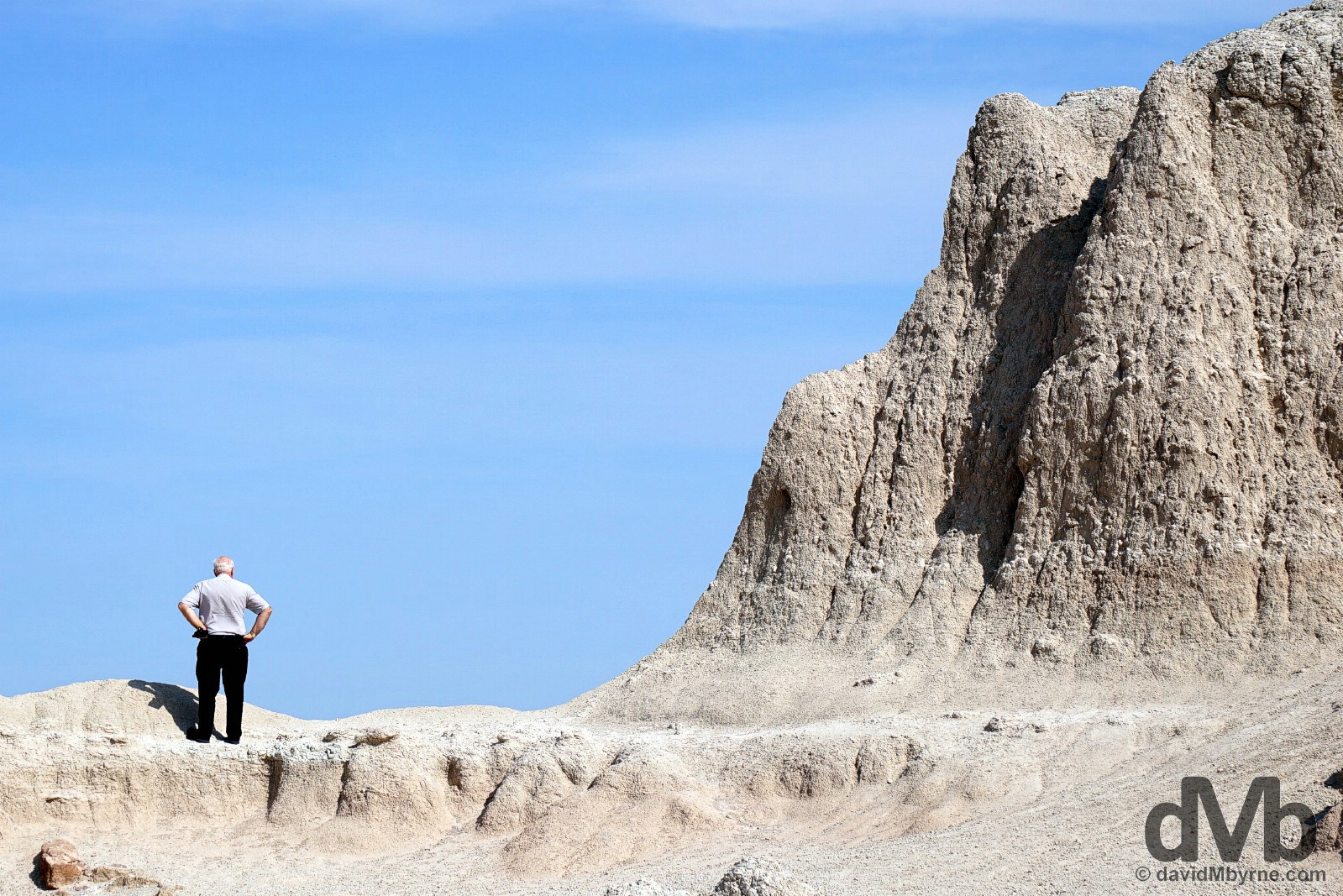
Only a 20-minute drive from Mount Rushmore National Memorial is yet another unfinished Black Hills carving undertaking, this one so monumental in scale as to almost relegate Mount Rushmore to something of an afterthought. The Crazy Horse Memorial, one of the world’s most overly ambitious examples of one-upmanship.
– Chief Henry Standing Bear in his 1939 invitation to sculptor Korczak Ziolkowski to carve the Crazy Horse Memorial
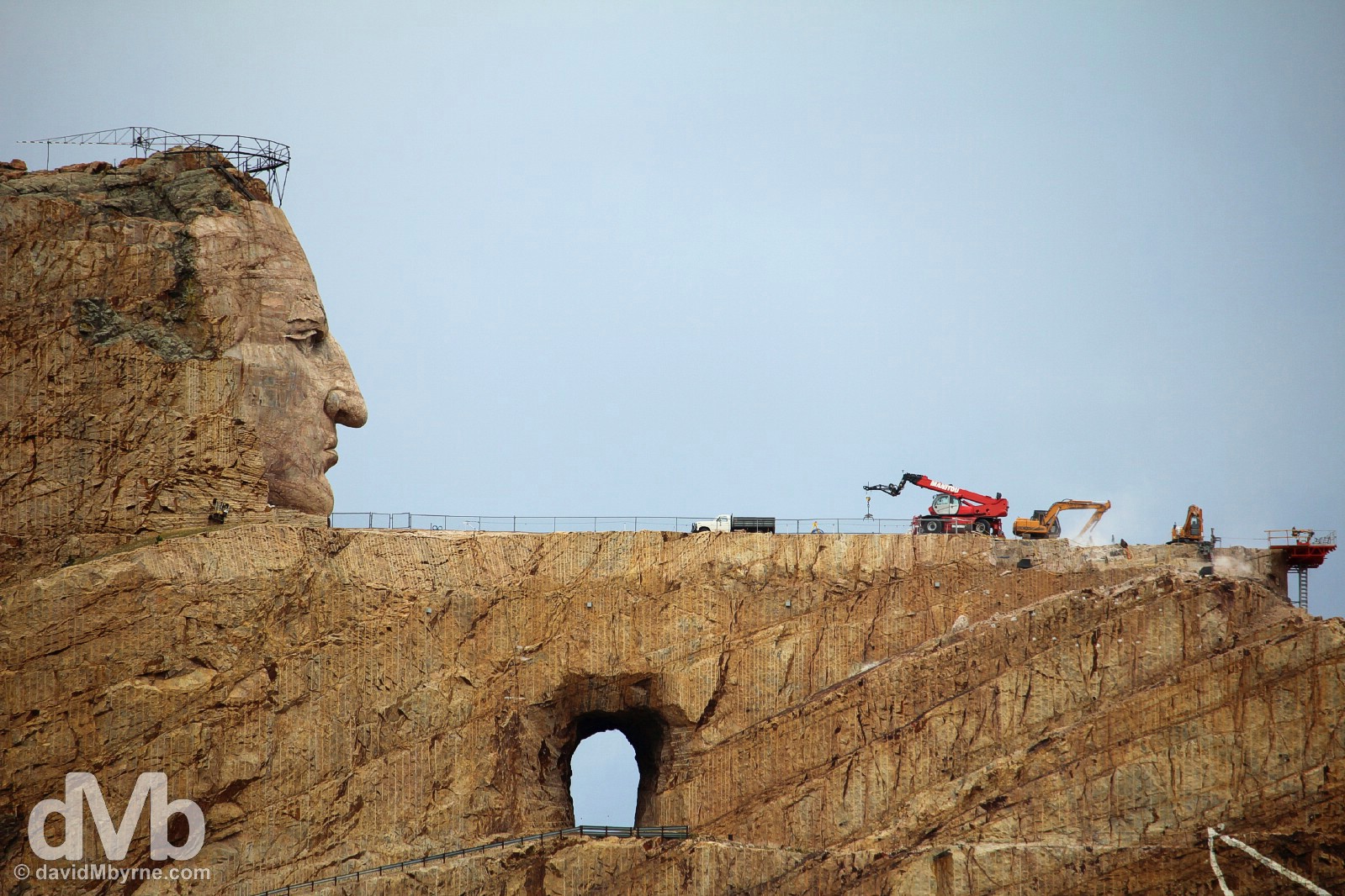
Cited, not surprisingly, to be the world’s largest monument when/if completed, the 172-metre-high (563 feet) work-in-progress that is the Crazy Horse Memorial was conceived by Chief Henry Standing Bear (1874-1953) of the Brule Lakota Indians as a direct competitor to nearby Mount Rushmore. It depicts, or will eventually depict, the forgotten Sioux leader Crazy Horse sitting astride his horse, pointing to the horizon saying “My lands are where my dead lie buried’ (in reply, it is said, to the derisive question asked by the white man, “Where are your lands now?” Ouch). Never photographed, the finished sculpture will depict a lineal likeness of Crazy Horse rather than an accurate resemblance. Standing Bear learned of Boston-born sculptor Korczak Ziolkowski when he worked on Mount Rushmore assisting Gutzon Borglum for a short time during the summer of 1939. Propositioned with the task that very same year, Ziolkowski accepted and, armed with dynamite, $174, and impressive levels of patience, began carving in 1948. Ziolkowski died in 1982 but his family continue today leading a team of 8 who slowly chip & blast away; by all accounts recruiting the right person for the job is both an on-going headache and an obvious impediment to project deadlines. To date only a small portion of the ambitious sculpture is complete – that is, or will be, Crazy Horse’s outstretched arm presently supporting the heavy-lifting machinery, and that is to be his pointed finger at the platform’s edge to the right of frame. No one is brave enough to predict when exactly the undertaking will be finished, although one staff member estimate says 50-60 more years will see the job done. Crazy Horse Memorial, Black Hills, South Dakota. September 2, 2016.
– Ian Frazier, Author, commenting on the Crazy Horse Memorial
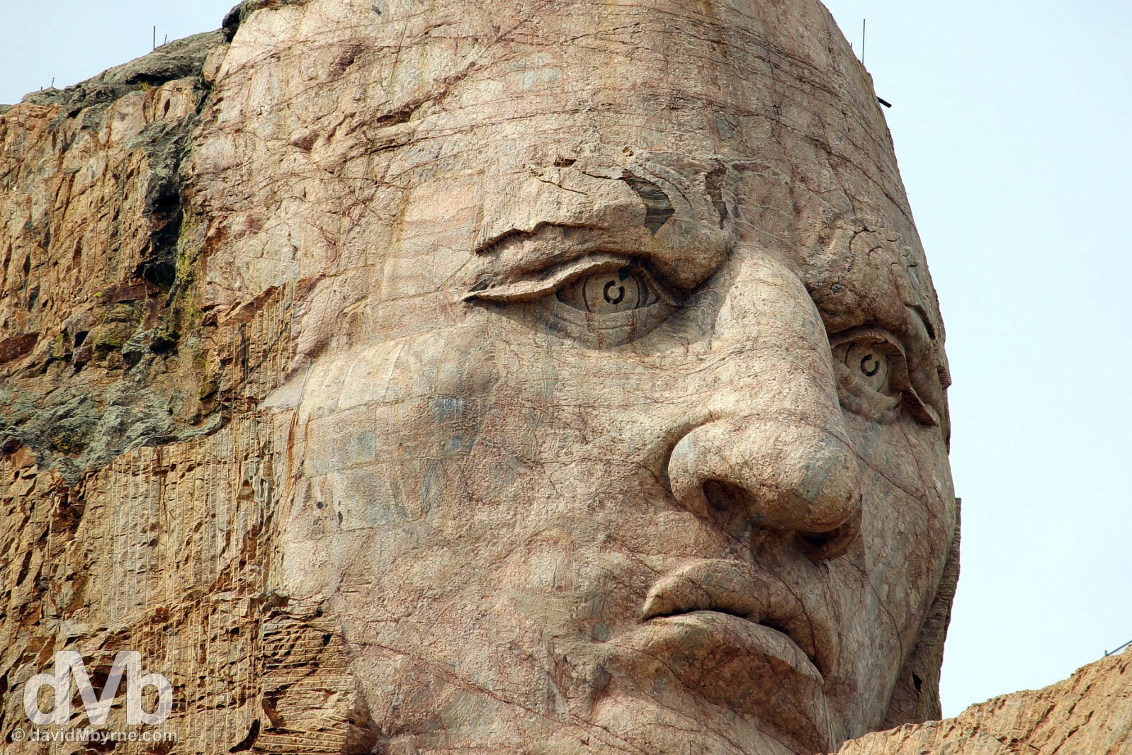
The first part of the Crazy Horse Memorial to be completed was the face, giving early & present-day visitors at least something to view. But it’s a case of lots done lots more to do, and not just with the carving. It – the carving – is only one feature, albeit the obvious centrepiece, of a much wider memorial complex by the shoot-for-the-stars Indians. The surrounding landscape, and in a bid by the self-funded Crazy Horse Memorial Foundation to protect and preserve the culture, tradition and living heritage of North American Indians, will eventually house the Indian University of North America, a Native American Educational & Cultural Centre, an Indian medical centre, the Indian Museum of North America (already in situ and nicely presented), and even an airport. It’s an ambitious plan all round. I wish them luck. They’re gonna need it. Crazy Horse Memorial, Black Hills, South Dakota. September 2, 2016.
Beyond the Crazy Horse Memorial, and just outside the town of Custer, it was time to drive the first National Scenic Byway of the wider road trip. And what an end-of-day treat that was.
National Scenic Byways & All-American Roads
![]()
While each state can and does designate its own Scenic Byways, a National Scenic Byway is a road recognized by the US Department of Transportation for one or more of six ‘intrinsic qualities’, they being archaeological, cultural, historic, natural, recreational, and scenic. The program was established by Congress in 1991 to preserve and protect the nation’s scenic but often less-travelled roads and to promote tourism and economic development. The National Scenic Byways Program (NSBP) is administered by the Federal Highway Administration (FHWA).
The most scenic byways are designated All-American Roads. These roads must meet two out of the six intrinsic qualities. An All-American designation means these roads have features that do not exist elsewhere in the US and are unique and important enough to be tourist destinations unto themselves.
As of November 2010 there are 120 National Scenic Byways and 31 All-American Roads located in 46 states (all except Hawaii, Nebraska, Rhode Island and Texas).
Named after local Governor, state & US Senator, & general natural resource conservationist Peter Norbeck (1870-1936), the Peter Norbeck National Scenic Byway is an 68-mile (110-kilometre) marrying of 4 different roads that link some unmissable Black Hills highlights including Mount Rushmore, Custer State Park and the Needles & Iron Mountain Highways.
– U.S. Department of Transportation Federal Highway Administration
The Needles Highway
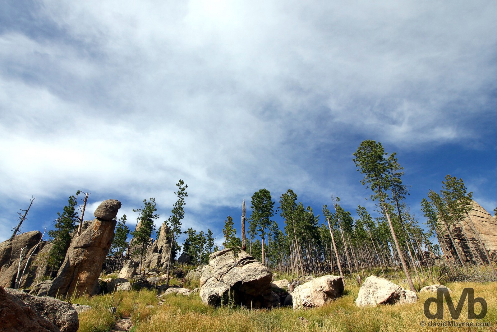
Curving between towering granite cliffs and ponderosa forests via hairpin turns & narrow tunnels, the 14-mile Needles Highway through the Harvey Range of Custer State Park was, when mapped out in 1919, billed as impossible to build via the conventional engineering means of the day. Two years and 150,000 pounds of dynamite later & the result was a winding road around, and sometimes through, a maze of upright sentinels of stone, some of the oldest rocks in North America, sheer granite formations reminiscent of organ pipes, spires and, yes, needles.
Closed in winter, the Needles Highway traverses a section of Custer State Park and is almost exclusively used by sightseers; this is a road built with tourists in mind. The road is narrow with many sharp turns, blind corners and two low tunnels blasted through sheer granite walls, the Needles Eye Tunnel seen here the most photographed of the two. Best not be in a hurry trying to get through here. Oh, and watch your wing mirrors. Tackling the Needles Eye Tunnel of the Needles Highway of Custer State Park, Black Hills, South Dakota. September 2, 2016.
– DangerousRoads.org commenting on the Needles Highway
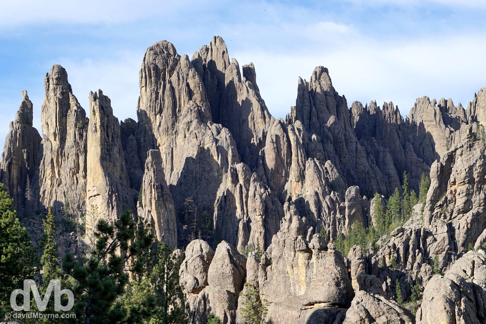
The granite Cathedral Spires of the Needles Highway, a region of eroded granite pillars which appear like organ pipes, are perhaps the most famous (natural) rock formation in the Black Hills. Popular with rock climbers, they were originally proposed as the site for the Mount Rushmore carvings, the location ultimately rejected due to the poor quality of the granite, the slenderness of the rock formations & objections from Indian groups. We ogled at this scene from the Needles Highway as the late afternoon sun was casting gorgeous shadows. The serenity & ever-present scent of ponderosa pine simply complemented the wonderful vistas. The Cathedral Spires of the Needles Highway in Custer State Park, Black Hills, South Dakota. September 2, 2016.
The Iron Mountain Highway
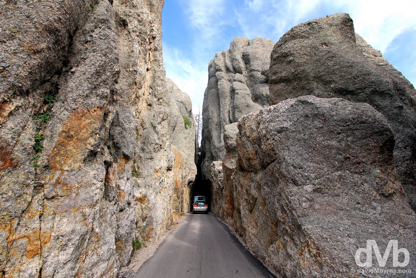
More dynamite was required for the Iron Mountain Highway of the Black Elk Wilderness region of the Black Hills, a road that manages to squeeze 314 curves & 14 switchbacks into its 17 mile run. A unique feature of this road, another one they said ‘couldn’t be built’, is a series of corkscrew spirals, a.k.a. the Pigtail Bridges, which see the road double back on itself allowing a rapid climb/descend to/from the route’s 1,660 metre (5,445 feet) summit. However, as impressive as that is to see (& drive), it’s the three one-lane tunnels encountered en route that are probably the lingering feature of the road, two of which, on the north side of Iron Mountain, were designed to frame the faces of the emerging Mount Rushmore National Memorial in the distance.

Mount Rushmore National Monument as seen through the Doane Robinson Tunnel of the Iron Mountain Highway, named after the South Dakota historian credited with conceiving the idea of carving the likenesses of famous people into the Black Hills in order to promote tourism in the region. Good foresight & a smart move. On The Iron Mountain Highway of the Black Hills in South Dakota. September 2, 2016.
– DangerousRoads.org commenting on the Iron Mountain Highway
THE UPPER MIDWEST || Wisconsin & Minnesota
DAY 01 139 miles || Chicago’s O’Hare Airport to Madison, Wisconsin
DAY 02 302 miles || Madison to Saint Paul, Minnesota (via Pewit’s Nest State Natural Area & Prescott, Wisconsin)
DAY 03 259 miles || Saint Paul to Bemidji, Minnesota (via St Cloud, Brainard & Walker, Minnesota)
THE DAKOTAS || North & South Dakota
DAY 04 458 miles || Bemidji to Bismarck, North Dakota (via Grand Forks, Lakota & Rugby, North Dakota)
DAY 05 459 miles || Bismarck to Deadwood, South Dakota (via Fort Yates, North Dakota & Badlands National Park, South Dakota)
DAY 06 167 miles || Deadwood & The Black Hills (Mount Rushmore National Memorial & Crazy Horse Memorial)
THE NORTHERN ROCKIES || Wyoming, Montana, Idaho, & Northern Utah
DAY 07 354 miles || Deadwood to Billings, Montana (via Devil’s Tower & Little Bighorn Battlefield National Monuments)
DAY 08 262 miles || Billings to West Yellowstone, Montana (via the Beartooth Highway & Yellowstone National Park)
DAY 09 227 miles || West Yellowstone to Jackson, Wyoming (via Yellowstone National Park & Grand Teton National Park)
DAY 10 280 miles || Jackson to Salt Lake City, Utah (via Alpine, Wyoming; & Montpelier, Paris, & Bear Lake, Idaho)
THE SOUTHWEST || Southern Utah, Arizona & New Mexico
DAY 11 330 miles || Salt Lake City to Panguitch, Utah (via Brian Head & Cedar Breaks National Monument)
DAY 12 273 miles || Panguitch to Page, Arizona (via Bryce Canyon National Park, & Zion National Park)
DAY 13 307 miles || Page (Horseshoe Bend) & Grand Canyon National Park (North Rim)
DAY 14 175 miles || Page to Kayenta, Arizona (via Upper Antelope Canyon, Arizona & Monument Valley, Utah)
DAY 15 252 miles || Kayenta to Durango, Colorado (via Monument Valley, Utah, the Four Corners Monument, & New Mexico)
THE ROCKIES || Colorado
DAY 16 348 miles || Durango to Leadville, Colorado (via Wolf Creek Pass & Monarch Pass)
DAY 17 299 miles || Leadville to Estes Park, Colorado (via Independence Pass, Aspen, Berthoud Pass, & Rocky Mountain National Park)
THE GREAT PLAINS || Wyoming, Nebraska, Iowa, Missouri & Arkansas
DAY 18 307 miles || Estes Park to Cheyenne, Wyoming (via Laramie, Como Bluff, Medicine Bow, & Buford, Wyoming)
DAY 19 404 miles || Cheyenne to Burwell, Nebraska (via Scotts Bluff National Monument & Carhenge, Nebraska)
DAY 20 407 miles || Burwell to Kansas City, Missouri (via Spalding, Nebraska; SW Iowa; & Omaha, Nebraska)
DAY 21 286 miles || Kansas City to St Louis, Missouri
DAY 22 322 miles || St Louis to Memphis, Tennessee (via Dyess, Arkansas)
THE SOUTH || Tennessee, Mississippi, Alabama & Georgia
DAY 23 308 miles || Memphis to Vicksburg, Mississippi (via Clarksdale, Yazoo City & Bentonia, Mississippi)
DAY 24 336 miles || Vicksburg to Prattville, Alabama (via Selma, Alabama)
DAY 25 297 miles || Prattville to Cornelia, Georgia (via Montgomery, Alabama & Stone Mountain, Georgia)
THE APPALACHIANS || Georgia, North Carolina, Virginia & West Virginia
DAY 26 261 miles || Cornelia to Asheville, North Carolina (via Helen & Brasstown Bald, Georgia & Great Smoky Mountains National Park, North Carolina)
DAY 27 200 miles || Asheville to Galax, Virginia (via the Blue Ridge Parkway)
DAY 28 004 miles || Galax, Virginia
DAY 29 354 miles || Galax to Lewisburg, West Virginia (via the Blue Ridge Parkway & Shenandoah National Park)
KENTUCKY & THE GREAT LAKES || Ohio, Kentucky, Indiana & Illinois
DAY 30 404 miles || Lewisburg to Lexington, Kentucky (via Chesapeake, Ohio; Cordell, Kentucky; & Sandy Hook, Kentucky)
DAY 31 241 miles || Lexington to Beaver Dam, Kentucky (via Lincoln Homestead State Park & Mammoth Cave National Park)
DAY 32 190 miles || Beaver Dam to Bloomington, Indiana (via Rosine & Owensboro, Kentucky)
DAY 33 282 miles || Bloomington to Chicago, Illinois (via Indianapolis, Indiana)
DAYS 34-36 017 miles || Chicago, Illinois