EPIC US ROAD TRIP 2016
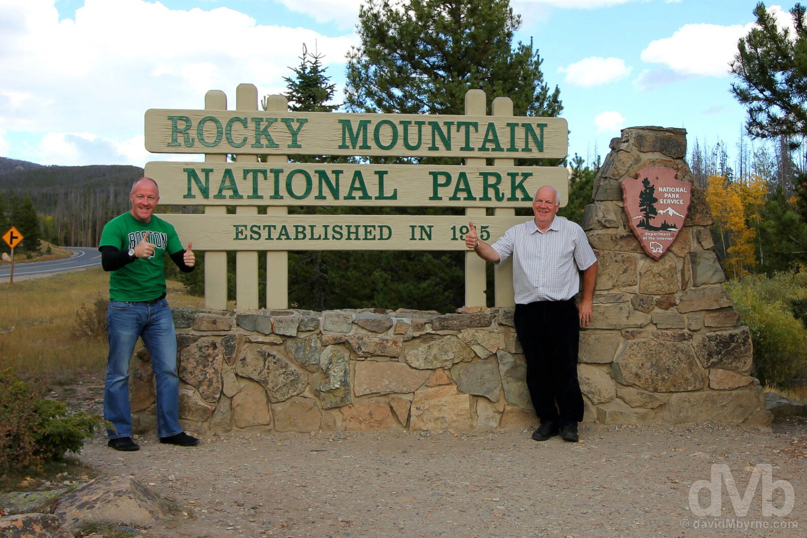
DAYS 16 & 17 - THE ROCKIES - COLORADOImage || Rocky Mountain National Park, northern Colorado.
Epic US Road Trip 2016 – The Rockies
Colorado is notable for its diverse geography, everything from vast prairie grasslands to majestic mountains. There’s even arid plains and deserts with deep canyons, sandstone rock formations and huge sand dunes, including the tallest dunes in North America. But that’s southern & southwestern Colorado. These plains eventually give way to the southern region of the Rockies, the chief mountain range of western North America that extends from Canada’s British Columbia to northern New Mexico while forming the Great Divide of the continent in the process. Synonymous with Colorado, these rugged & majestic mountains are blanketed by alpine vegetation & crisscrossed by out-of-the-way drives over high-altitude passes connecting archetypical Wild West mountain towns boasting well-preserved Victorian downtowns. That is what Colorado was always going to be about for me and by and large it lived up to its lofty Rocky Mountain stereotypes: we drove the highest continuously paved road in the country; we overnighted in the highest incorporated city in the country; and we crossed the highest paved Pass over the Continental Divide of North America. It was two days of high Rocky Mountain highs.
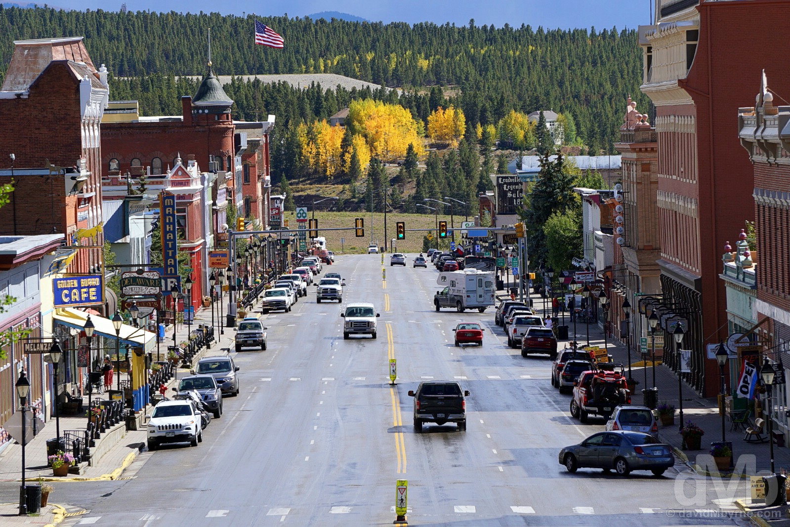
Elevation & beauty. Harrison Avenue in Leadville, the highest incorporated city in the US. Lake County, central Colorado. September 13, 2016.
![]() Colorado
Colorado
State Nickname – The Centennial State. State Motto – Nil Sine Numine (Nothing Without Providence). Admitted To The Union – August 1876 (38th state). Population – 5.5 million (22nd most populous state). Area – 104,000 sq miles (8th largest state). Capital – Denver. National Parks – 4 (Rocky Mountain, Black Canyon of the Gunnison, Great Sand Dunes, & Mesa Verde). National Scenic Byways/All-American Roads – 9/2. Famous For – Rocky Mountain highs; plush ski resorts; hot springs; altitude; Rocky Mountain Oysters (fried bull’s testicles); college party towns; Samsonite luggage. State Highlights – Alpine vistas & clean mountain air. Colorado Titbits – One of only three states, the others being Wyoming & Utah, whose borders are defined solely by lines of latitude and longitude; the state boasts 52 fourteeners, mountains over 14,000 feet (4,267 metres), & the 30 highest major summits of the Rocky Mountains of North America all lie in Colorado; Colorado is the only US state that lies entirely above 1,000 meters in elevation; The crest of the Rockies, and thus Colorado, straddles the Continental Divide of the Americas, the principal and largely mountainous hydrological divide of the Americas; Colorado is the least populous state with a franchise in each of the major professional sports leagues; In 2014, Colorado became the first US state to legalise the recreational use of marijuana; it’s the skinniest state, boasting the lowest rates of obesity in the country. It must be all that clean mountain air promoting active, healthy lifestyles.
Colorado. State #11. Durango, southern Colorado. September 12, 2016.
Image ||Durango, southern Colorado.
“It began as a railroad town in 1880 so I guess it’s only appropriate that present-day Durango, a charming old Wild West mining town with some gorgeous Victorian-era architecture, oozes train vibes.”
Day 16 || September 12 2016
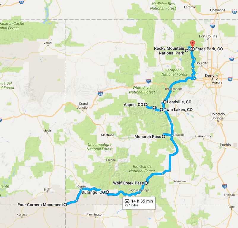
Route || Durango to Leadville, Colorado (via Wolf Creek Pass & Monarch Pass)
Miles (Kilometres) Driven || 348 (560)
Posted From || Leadville, Colorado
Today’s Highlight || Downtown Durango
A morning snoop around charming museum-piece Durango following a hearty Oscar’s breakfast. An overdue visit to a car wash to rid our ride of stubborn red US Southwest dust. One wrong turn, three ascents to two mountain passes over 10,000 feet & three crossings of the Continental Divide. Road Epic US Road Trip day 16, the first of two days of high Rocky Mountain highs.
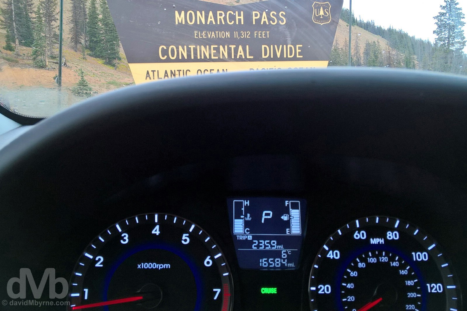
Whoops. The wrong turn. Atop Monarch Pass astride the Continental Divide, south-central Colorado. September 12, 2016.
It began as a railroad town in 1880 so I guess it’s only appropriate that present-day Durango, a charming old Wild West mining town with some gorgeous Victorian-era architecture, oozes train vibes. A toy train complete with choo-choos & steam does a loop of the counter in Oscar’s, a 50’s style diner and a local favourite for breakfast & lunch, while a real albeit long-in-the-tooth train, the historic Durango & Silverton Narrow Gauge Railroad, is probably the town’s biggest attraction.
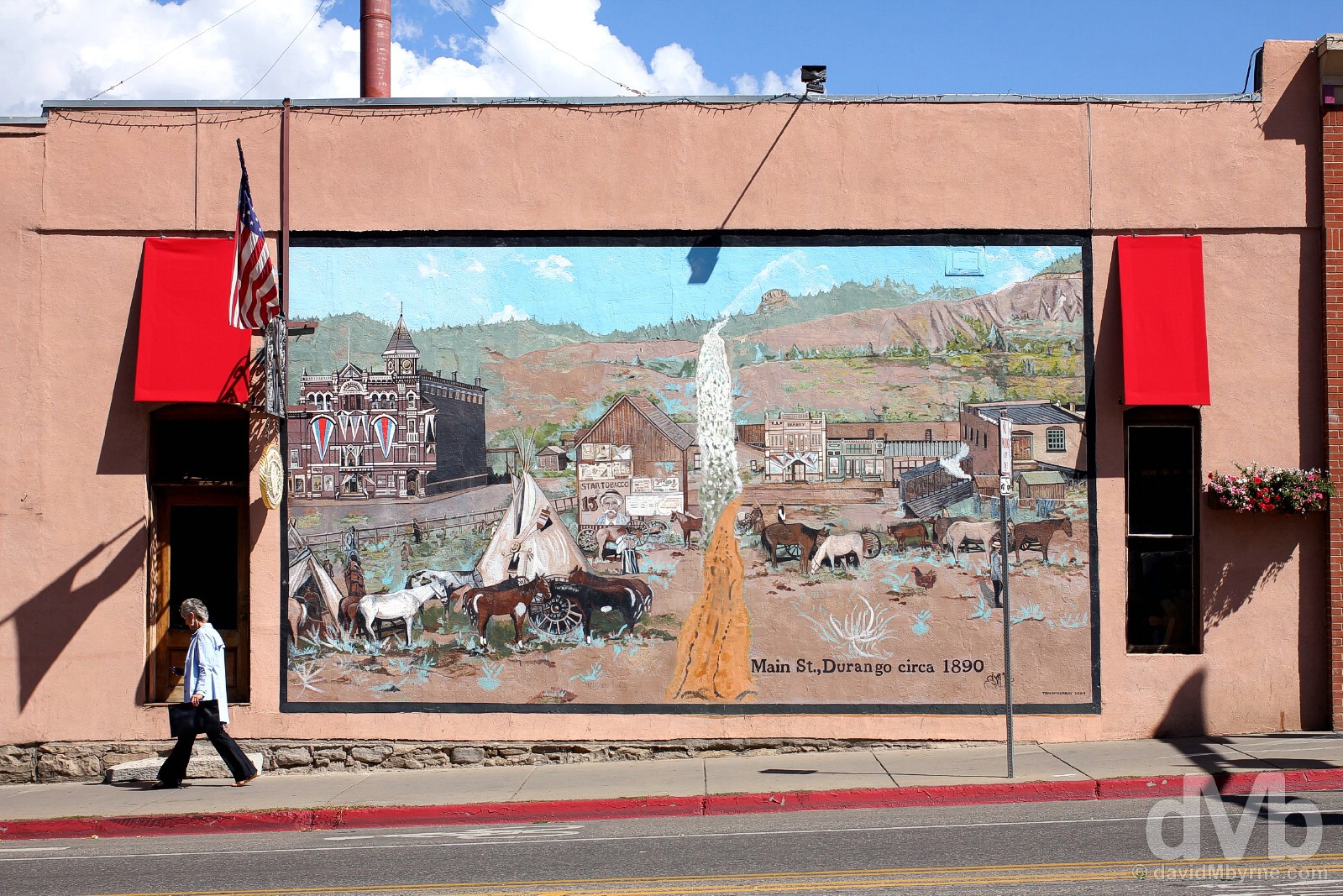
Durango, Colorado. Founded in 1880 and still charming to this day. September 12, 2016.

Durango’s inviting Main Avenue boasts not one but two graceful hotels, both surviving remnants of the town’s early days. The 1898 Victorian-era General Palmer Hotel is a sight but even it plays second fiddle to the old-world Strater Hotel on the corner of Main Avenue & 7th Street. An eclectic mix of Italianate, Romanesque and Renaissance architectural styles, it opened in 1888 to satisfy the fledgling town’s desire for a landmark hotel. 128 years later and it’s still Durango’s flagship building. Main Avenue, Durango, southern Colorado. September 12, 2016.
– From www.Durango.org
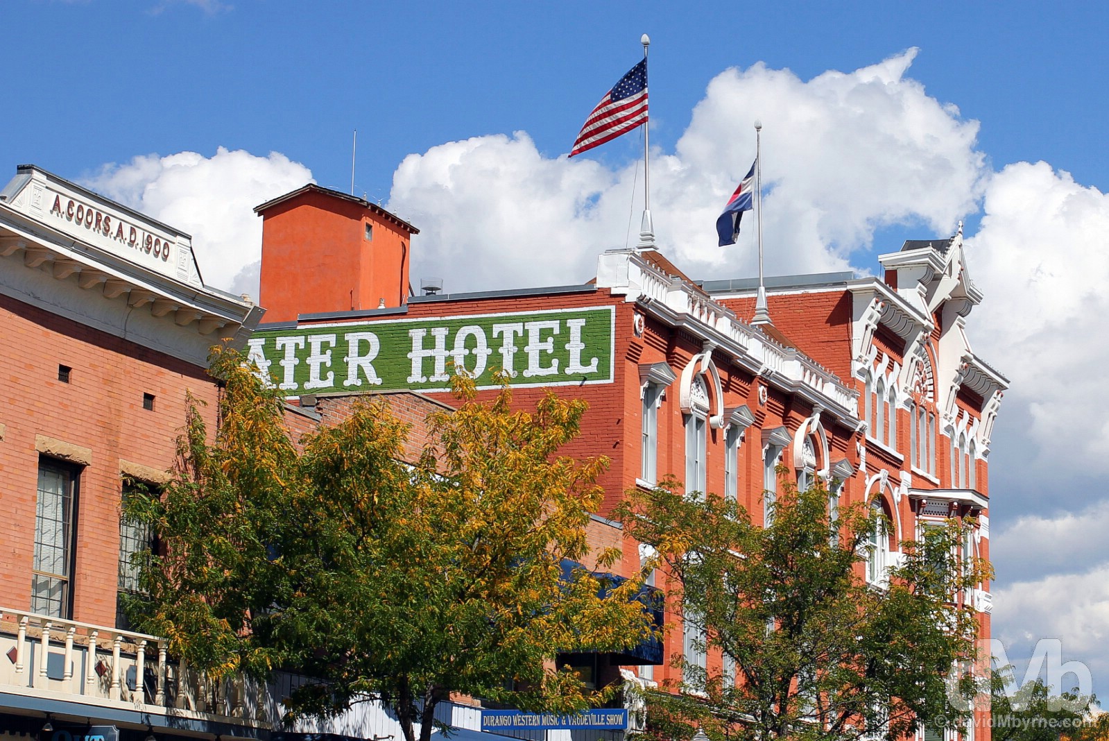
Another view of the Strater Hotel beside which is a building that was until 1915 owned by Adolph Coors, the German American brewer who founded the Adolph Coors Company in Golden, Colorado, in 1873 hence the text on the facade dating to 1900. Main Avenue, Durango, southern Colorado. September 12, 2016.
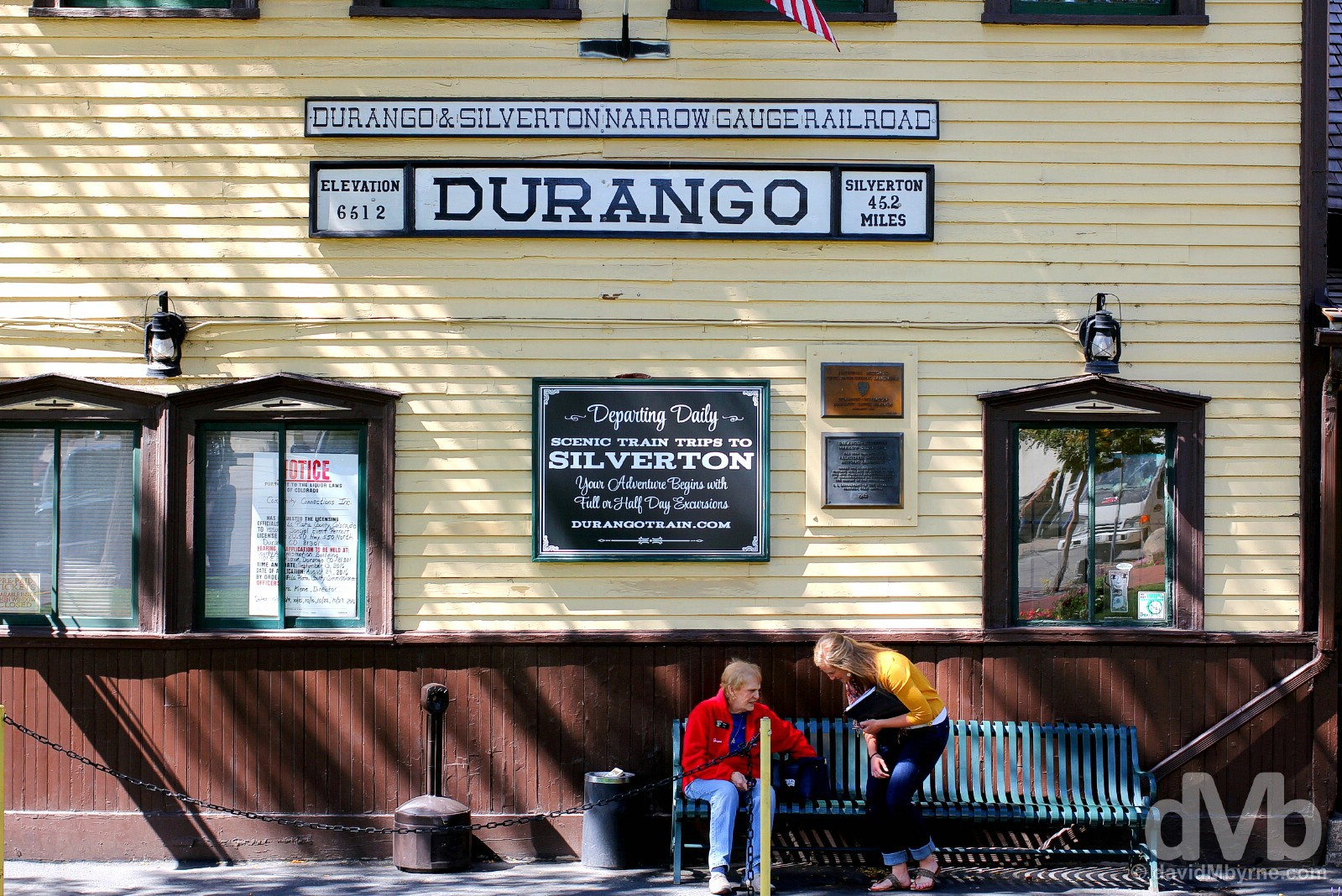
A National Historic Landmark since 1961, the heritage Durango & Silverton Narrow Gauge Railroad connects Durango with Silverton, a 45.2-mile service that has been in operation continuously since 1881. Originally a freight train, it was promoted in 1951 as a passenger train and today operates as a tourist attraction between the months of May & October, steam-driven vintage locomotives dating to the 1880s taking over 3 hours to choo-choo their way along the a scenic route following the course of the region’s Animas River. The depot in Durango, seen here, was built in January 1882. Preserved today in its original form and still operational, it houses a period ticket office, a cafe and a souvenir shop with all manner of railroad-branded goodies. The Durango & Silverton Narrow Gauge Railroad Depot, Main Avenue, Durango, southern Colorado. September 12, 2016.
It’s over 330 miles from Durango to Leadville, quite the drive considering the topography. It took us almost 7 hours to cover that distance today, but only because we took a wrong turn; otherwise it would have taken less than 6. We expected to drive over 1 high-altitude pass but actually encountered two. That wrong turn again.
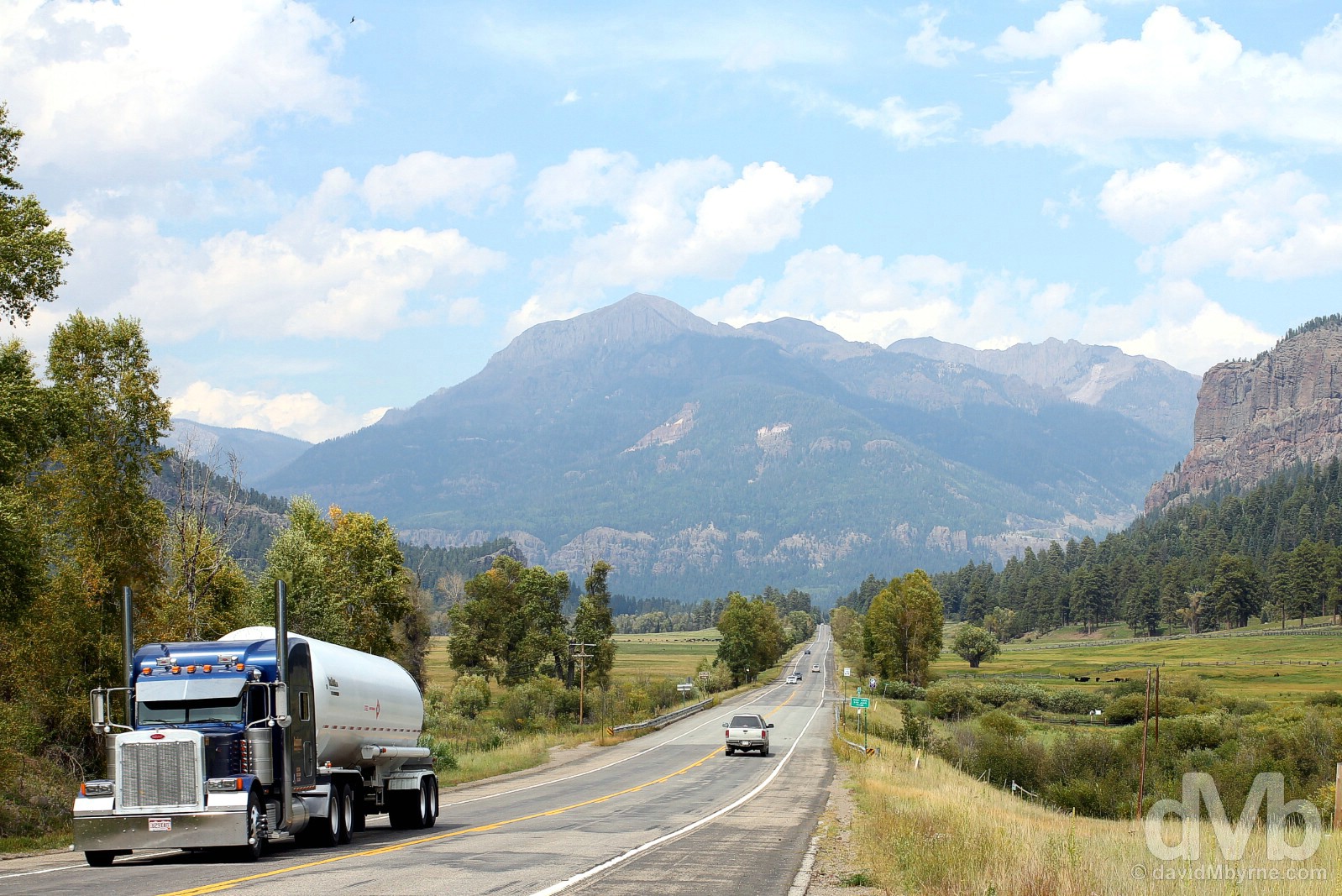
Although Durango is surrounded by mountains, it wasn’t until we drove some distance east of the town that we felt we were truly heading for the hills. We had yet to noticeably climb when this image of Rocky Mountain peaks was captured from the side of US Highway 160, about 30 minutes out of Durango. Soon thereafter and the climb would begin and with it our road-trippin’ adventures in the Colorado Rockies. US Highway 160, southern Colorado. September 12, 2016.
Road-Trippin’ in Colorado
As a mountain state and the only such state in the US that lies entirely above 1,000 meters in elevation, Colorado is a rather good choice for a road trip, and an excellent choice for a road trip within a road trip.
– Lonely Planet USA, 6th Edition
Given the regional topography, roads around here are rarely flat and rarely go in straight lines. This invariably means that getting from A to B will take longer than expected, granting more time to admire the obvious views – with the state boasting 52 fourteeners, mountains over 14,000 feet (4,265 metres) in elevation, stunning mountain vistas are guaranteed. Snow is an obvious concern but we doubt we’ll have to worry about that – while not unheard of this time of year, by being here in mid-September we’re some weeks ahead of the winter snow.
Eighty miles beyond Durango and we reached Wolf Creek Pass, the first but by no means the last of the Colorado Rocky Mountain passes straddling the Continental Divide of the Americas, a.k.a. The Great Divide, that we’d encounter.
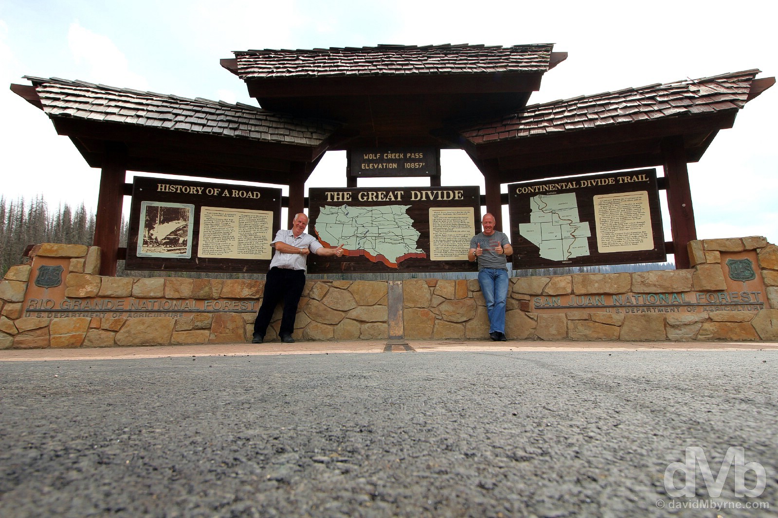
Although we made all the advances, it felt like Wolf Creek Pass kind of snuck up on us. There was of course a climb to the 10,857-feet (3,309-metre) Pass, but not a very noticeable one despite the advertised ‘steep’ 6.8% maximum grade on either side. As a result we almost drove past the Pass, and over the Continental Divide, without even noticing it. Named after a 19th century squatter-trapper by the name of Bill Wolf, this is the highest point of a legendary stretch of US Highway 160 across the San Juan Mountains of the southern Rockies, a route made famous in the 1975 C. W. McCall song Wolf Creek Pass in which the road is described as “37 miles o’ hell which is up on the Great Divide.” Not as challenging an undertaking as it once was, the road opened in 1916 at a time when it took on average 2 days to drive across in a Model-T Ford. Upgraded in recent times, it is now a broad multi-lane highway somewhat masking, especially in warmer months, any sense that this is in fact a dangerous, high-altitude alpine road. Needless to say it’s a different story in winter, a different kind of challenge. With an average annual snowfall of some 38 feet (11.5 metres), Wolf Creek Pass is known for its deep, stable snowpack – in most seasons it has double or triple the snowpack of the northern or central Colorado mountains earning it the title of ‘Snow King’ of Colorado roads by DangerousRoads.org. As a result, and even though it’s kept open year-round, most over-the-road truck drivers will happily take an alternate route during the colder months thus avoiding the so-called ‘bearcat’ of mountain passes altogether. Wolf Creek Pass on US Route 160, south-central Colorado. September 12, 2016.
Continental Divide of the Americas
The Continental Divide of the Americas, a.k.a. The Great Divide, is essentially the spine of the Western Hemisphere, the principal and largely mountainous hydrological divide of the North & South American continents. Extending from the Brook Range in Alaska to the Strait of Magellan at the tip of mainland South America, in essence it, and because water flows from a height, separates the watersheds that drain into the Pacific Ocean from those that drain into the Atlantic Ocean. Though there are many other hydrological divides in the Americas, the Great Divide is by far the most prominent as it tends to follow a line of high peaks along the main ranges of The Rocky Mountains of North America and The Andes of South America. As the backbone of the North American continent, the Divide follows the crest of the Rockies and when standing at the Continental Divide signage encountered on any Rocky Mountain Pass you are symbolically standing astride the spine of the Western Hemisphere.
Monarch Pass
It’s a 130-mile drive from Wolf Creek Pass to Monarch Pass, a Pass that really did sneak up on us. We shouldn’t have been anywhere near it.
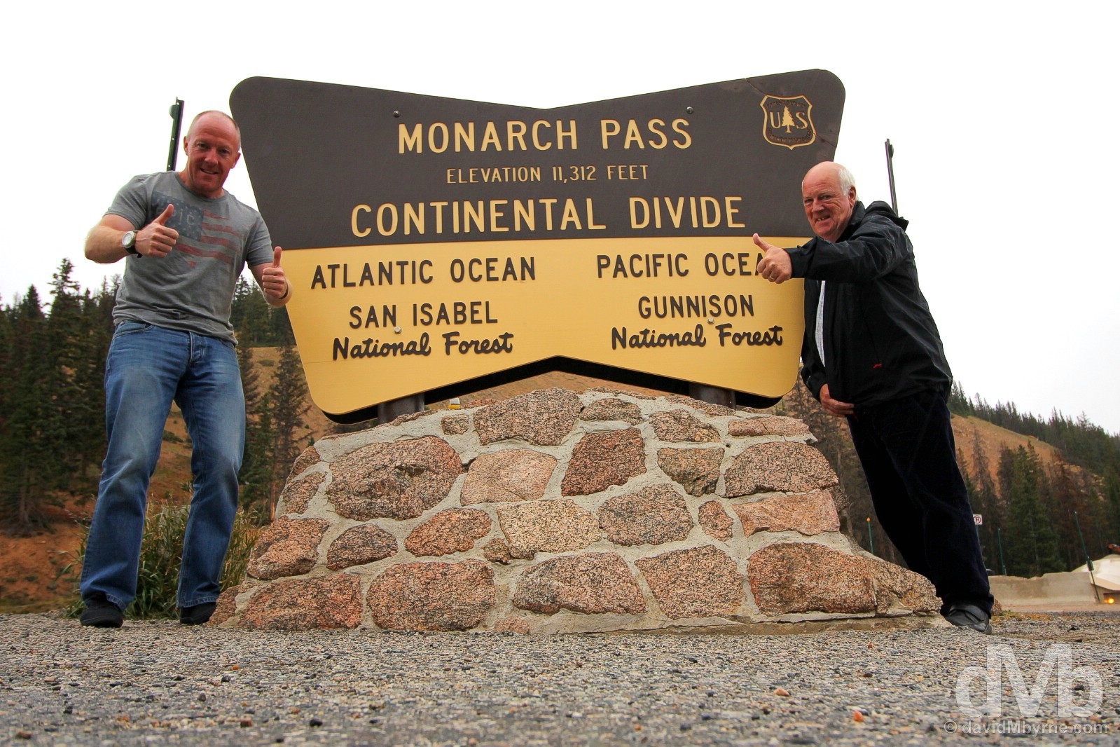
It was only when we were some 25 miles down the other side of Monarch Pass, heading west, that we realised we were going in the wrong direction; we needed to be going north. Always north. We’re not quite sure how we ended up here but once we realised the error of our ways it was easily put right, necessitating an about-turn near the community of Parlin on US Highway 50, another ascent to the Pass & thus two trips across the Continental Divide. Although only 455 feet (139 metres) higher than Wolf Creek Pass, it was much colder here than it was on Wolf Creek. Wet too, the chill & rain meaning we didn’t venture out of the car for too long. The Pass has a cable car, the Monarch Crest Tramway, which boasts of providing ‘a breathtaking ride along America’s Continental Divide’ and that ‘no place in America has the view you will see from the top’, views of 5 major mountain ranges and vistas stretching for 150 miles on a clear day. Today wasn’t clear and even if it was the tramway wasn’t in service. The Pass was deserted, which was probably just as well. Voted ‘Worst Odds For A Wipeout’ in Colorado by DangerousRoads.org, the Monarch Pass road claims the highest wreck rate of all Colorado passes with an average of 60 wrecks in the last three years alone. Atop Monarch Pass, US Highway 50, central Colorado. September 12, 2016.
Leadville – An Introduction
Accidentally driving not once but twice across the most accident-prone road in Colorado meant it was after dark when we pulled into Leadville, a 75-mile, 90-minute drive from Monarch Pass. The frontier mining town is surrounded by some of the highest peaks in North America including Mount Elbert, at 14,440 feet (4,401 metres), the loftiest of Colorado’s 52 fourteeners & the second-highest peak in the contiguous US. The air is a bit finer up here in Leadville, a.k.a Cloud City. Sitting at an altitude of 10,152 feet (3,095 metres) makes Leadville the highest incorporated city in the whole of the US. More from Leadville tomorrow but for an introduction this evening it did very little wrong in our eyes: we were welcomed to the town’s Timberline Motel by a local who shared our very Irish surname; we were treated to some bluegrass music while having burgers & beers in the rustic Tennessee Pass Cafe; and the town’s Silver Dollar Saloon, dating to 1879, bills itself as not only ‘The Best Wild West Saloon in America’ but also as an ‘Irish’ bar. OK so it’s about as Irish as Che Guevara, has no beer on tap and had no customers on this night save for us. But it does have cheap bottled beer, a good jukebox, an affable barman, undeniable history & an interior that hasn’t changed much in 137 years. All in all a day of highs ended on one.
Image ||Rocky Mountain National Park, Colorado.
“… a windswept alpine world where conditions are said to resemble those found in the Canadian or Alaskan Arctic. It would have been nice to experience some of that, but as it was we could scarcely see where the treeline ended and the alpine tundra environment began.”
Day 17 || September 13 2016
Route || Leadville to Estes Park, Colorado (via Independence Pass, Aspen, Fremont Pass, Berthoud Pass, & Rocky Mountain National Park)
Miles (Kilometres) Driven || 299 (481)
Posted From || Estes Park, Colorado
Today’s Highlight || The drive over Independence Pass
After unintentionally going out of our way yesterday, today we intentionally did just that. In getting here to Estes Park from Leadville via out-of-the-way Aspen, we subjected the little Hyundai Accent to 6 different high-altitude mountain passes, two National Scenic Byways & one All-American Road, including the highest continuously paved road in America. It was a toil and no mistake. Ultimately our little charger wasn’t up to the task and after 17 days and 4,890 miles of adventure our Illinois registered Hyundai Accent had had enough, giving up the ghost for good having largely freewheeled from a Rocky Mountain high down into Estes Park. We enjoyed the Colorado Rockies. Unfortunately the same can’t be said for the Hyundai. Hertz! We’re going to need a new car, please.
Early morning on Harrison Avenue, Leadville, central Colorado. September 13, 2016.
Historic Leadville
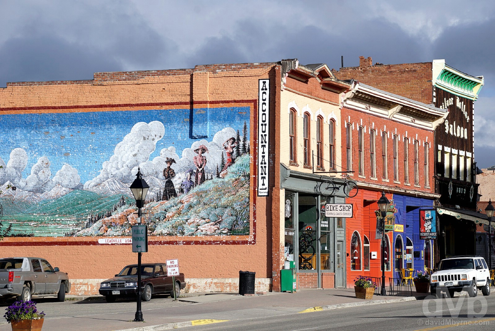
Leadville was a treat. Is a treat. One of the most notable historic towns in Colorado and something of a regional hub, North America’s highest incorporated city was the frontier West’s wildest & richest silver mining boom town. Today this history is preserved via Leadville’s National Historic District. Designated in 1961, this encompasses twenty square miles of Leadville’s now defunct mining district & seventy square blocks of Victorian architecture centred on the notable buildings lining Leadville’s Harrison Avenue, many of which were collectively inscribed on the the National Register of Historic Places in 1966. Historic Leadville indeed.
Harrison Avenue, Leadville, central Colorado. September 13, 2016.
With a present-day population of approximately 2,500, there’s more to the town of Leadville than what you see on Harrison Avenue, but it is on the town’s main drag where Leadville best keeps alive its heritage as a frontier mining town. Gold was discovered in California Gulch, about 4 miles away, in 1860. That gold was quickly depleted and the miners scattered only to return 17 years later, in 1877, with the discovery of silver in the nearby Pine Woods. There was much more silver than gold and Leadville was to blossom into one of the most famous silver mine towns on earth. Thousands made (& lost) their fortunes here and by 1890 Leadville was second only to Denver as Colorado’s largest city. The town is a little quieter these days, a tad less frontier-esque, but many Victorian-era architectural gems & historic structures from the town’s mining heyday remain to ensure Leadville is, and as I have stated before, a treat for those who make the effort to get up here.
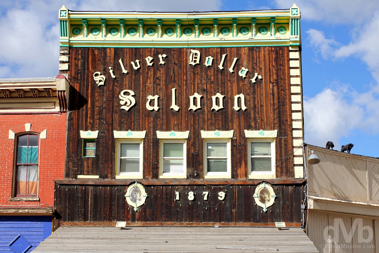
It wasn’t exactly a dawn chorus but the two dogs gnarling at us from on high early this morning made some noise. Harrison Avenue was built off the back of mining wealth and the artery was once lined with plush hotels, opera houses, hardware stores, a grandiose Court House and of course the ever-present drinking and gambling establishments. One such Leadville den of iniquity was the ‘The Board of Trade’, a house of gambling & drinking that opened in 1879. Surviving prohibition, it was purchased in 1943 by a Martin McMahon and in 1963 officially became both the Silver Dollar Saloon and the centre of Irish activity in the town. Now well into its second century, I’d imagine the building looks today very much like it did back then, the old wooden character of the creaking structure still very much present thanks mainly to its original mammoth white oak back bar, rustic furnishings & tile flooring. Inscribed on the National Register of Historic Places, its claim as ‘The Best Wild West Saloon in America’ might just be valid. However, its claim of being an Irish bar is a tad more questionable. The Silver Dollar Saloon, Harrison Avenue, Leadville, central Colorado. September 13, 2016.
– Reproduced from the Silver Dollar Saloon’s History of Leadville
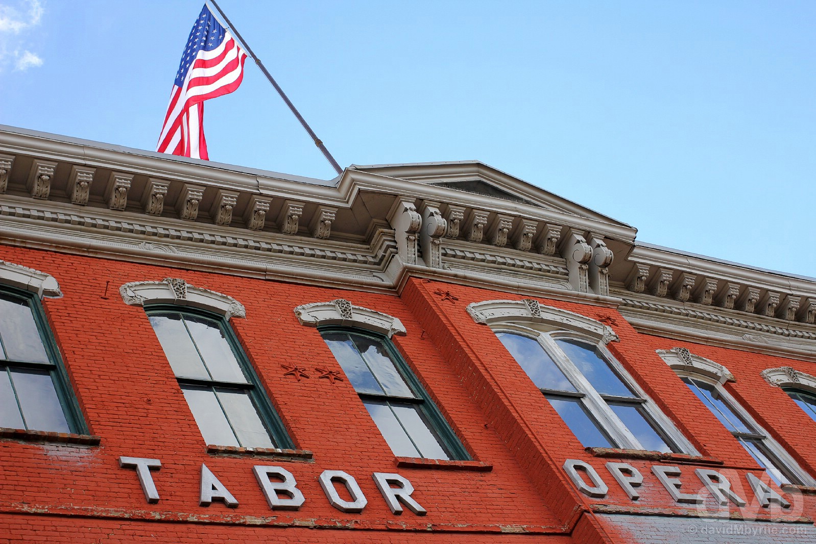
Probably Leadville’s most famous building constructed off the back of mining fortunes, and one also inscribed on the National Register of Historic Places, the Tabor Opera House was built by Horace Austin Warner Tabor, one of Colorado’s most well-known mining magnates and otherwise known as ‘The Bonanza King of Leadville’. One of the most costly and substantially-built structures in the state of Colorado, the 3-storey building was constructed of stone, brick & iron, material that needed to be hauled up into Leadville via wagons. Built in a bid to ‘class up’ and bring some culture to the unrefined mining town, it opened after a 100-day build on November 20 1879 for the play The Serious Family, the theatre’s very first production; in subsequent years the Tabor stage would be graced by the likes of Harry Houdini, Oscar Wilde and Buffalo Bill Cody. Listed only this year as one of Colorado’s Endangered Places by the Colorado Preservation Inc., the Tabor is still in limited use today in need of ongoing upkeep & restoration. To that end, The City of Leadville is presently trying to raise the necessary funds to purchase the historic building with a view to it becoming a cultural hub and event centre for the citizens of the town. The Tabor Opera House, Harrison Avenue, Leadville, central Colorado. September 13, 2016.
Leadville sits pretty in the middle of Colorado’s Top of the Rockies National Scenic Byway, a route that seldom dips below 9,000 feet (2,745 metres) in altitude. The three-pronged byway branches out in various directions from Leadville. North is where we’re ultimately heading but, and when pursuing options this morning in Leadville, we decided to embark a 120-mile round trip south & west to the plush Rockies ski town of Aspen, a trip that necessitated two ascents of the region’s Independence Pass, one of the highest of all mountain passes over the Rockies & the highest of all paved passes over the Continental Divide in North America.
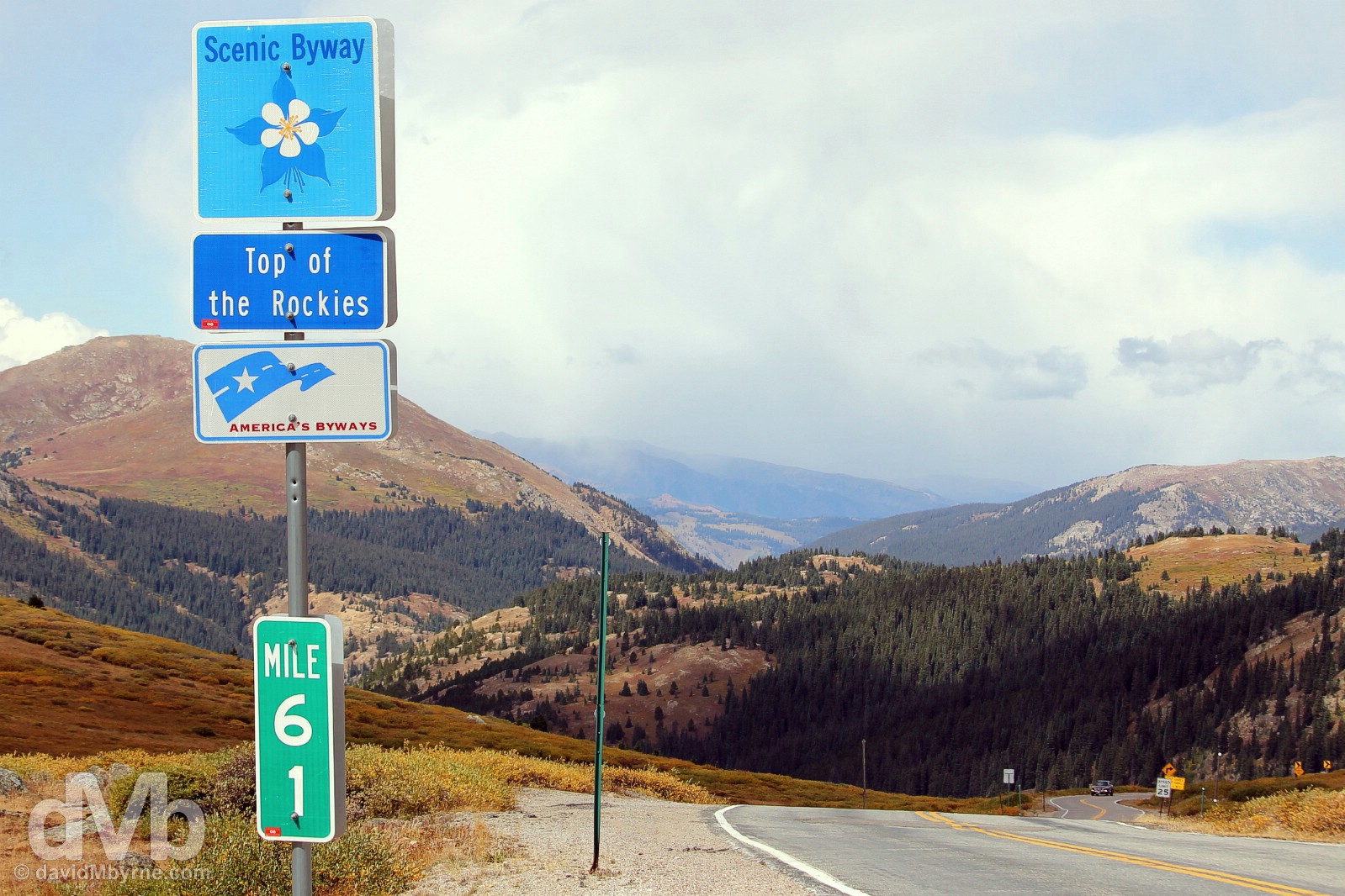
Top of The Rockies National Scenic Byway signage on Independence Pass, Colorado State Route 82, central Colorado. September 13, 2016.
– TopofTheRockiesByway.org
It’s 60 miles from Leadville to Aspen over Independence Pass. However, it’s the 40-mile stretch of Colorado State Route 82 between the charming settlement of Twin Lakes & Aspen that goes some way to earning the road its National Scenic Byway accreditation. Skirting the base of 14,433-feet (4,400 metre) Mount Elbert, Colorado’s highest peak & the second-highest peak in the Contiguous US, the road is picturesque, and that’s even before the steep climb to the Pass begins in earnest.
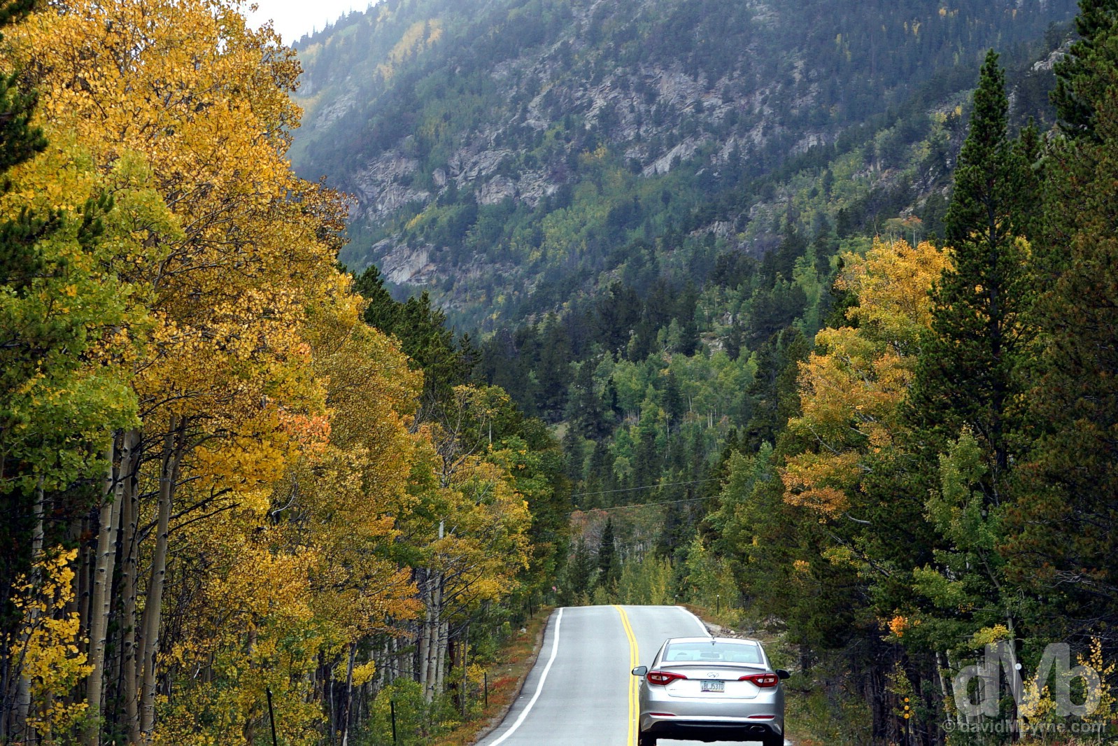
On a tree-lined portion of Colorado State Route 82 at the base of Mt. Elbert, Colorado’s highest peak, en route from Twin Lakes to Aspen, via Independence Pass, central Colorado. September 13, 2016.
Usually closed to all traffic for half the year, & strictly off-limits to trucks or other large vehicles even in good weather, the eastern approach to Independence Pass has many small and three rather large switchbacks. Although the 2-lane road is in good condition the ascent is steep and the going slow. However, eventually one reaches the apex, Independence Pass.
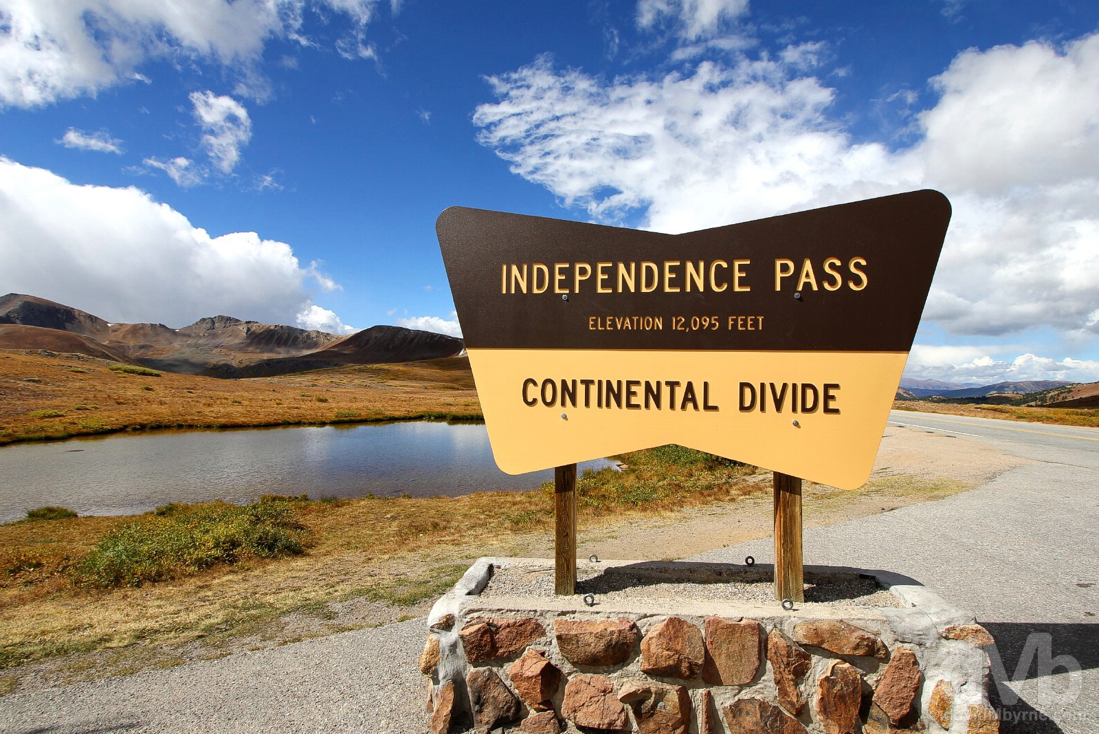
The apex of Colorado State Route 82’s traverse of the Sawatch Mountains between Twin Lakes and Aspen is marked by Independence Pass, at 12,095 feet (3,686 metres) the highest paved road crossing the Continental Divide in North America. First surveyed in 1873 & believed first crossed in 1879 by prospectors from the Leadville & Twin Lakes region, the first real road over the Pass was built in 1880-1881 by B. Clark Wheeler, a prominent businessmen from Aspen. Using hand tools and manual labor, Wheeler’s crew established a toll road along the route of the trail that had previously been used by Native Americans, prospectors & mule trains. The road saw heavy traffic & for much of the 1880s, when it was known as Hunter’s Pass, it was the only road in and out of the region’s Roaring Fork Valley, a year-round route of thrills & terror with steep drop-offs, loose rock and unpredictable, changeable weather. Railroad access to Aspen in 1887 spelled the end for the toll road which gradually fell into disuse and neglect. Known today as Independence Pass after the booming mining town of Independence that sprung up near the summit, now a ghost town and popular tourist attraction, the State of Colorado designated State Highway 82 over the Pass in the 1920s & rebuilt the road to its current alignment in the process. Not fully paved until 1967, the Pass is now only open half the year typically from mid-May to mid-October. On Independence Pass on Colorado State Route 82, central Colorado. September 13, 2016.
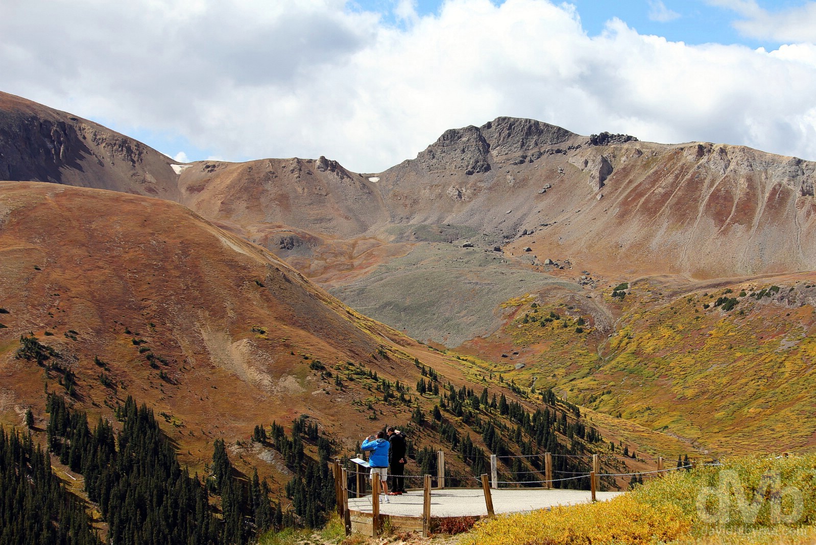
At the eastern-orientated Independence Pass viewpoint overlooking the region’s Roaring Fork Valley, Lake Creek Valley, Collegiate Range, Sawatch Range and West Elk Range. The Rocky Mountains are largely covered with trees such as conifers and aspens up to the tree line, an elevation of about 11,000 feet (3,353 metres) here in central Colorado (the tree line varies, increasing in elevation the further south you go). Above the tree line only alpine vegetation grows. Only small parts of the Colorado Rockies are snow-covered year round, the exception being a few snow-capped peaks and a few small glaciers. Even here, at over 12,000 feet on the highest paved pass of the Continental Divide in North America, there’s an absence of snow this time of year. Atop Independence Pass, Colorado State Route 82, central Colorado. September 13, 2016.
On the swish streets of affluent Aspen, Colorado. September 13, 2016.
Aspen
Once sitting somewhat isolated in Roaring Fork Valley west of the Continental Divide, the Aspen area was originally inhabited by Native American Ute Indians. The town was founded as a mining camp – silver mining quickly took hold in the late 1880s shortly after the first prospectors crossed over the then Hunter’s Pass (now Independence Pass) from Leadville and other more developed mining towns east of the Continental Divide – and was named after the abundance of aspen trees in the area. The Native Indians were relocated to reserves in 1881 & the railway arrived in 1887 at the height of the mining boom that founded the town. When the boom went bust Aspen went into decline only waking from the so-called ‘quiet years’ in the mid-1900s with the development of the skiing infrastructure in the surrounding hills that today makes the town the world-renowned ski & apres ski location par excellence that it is.
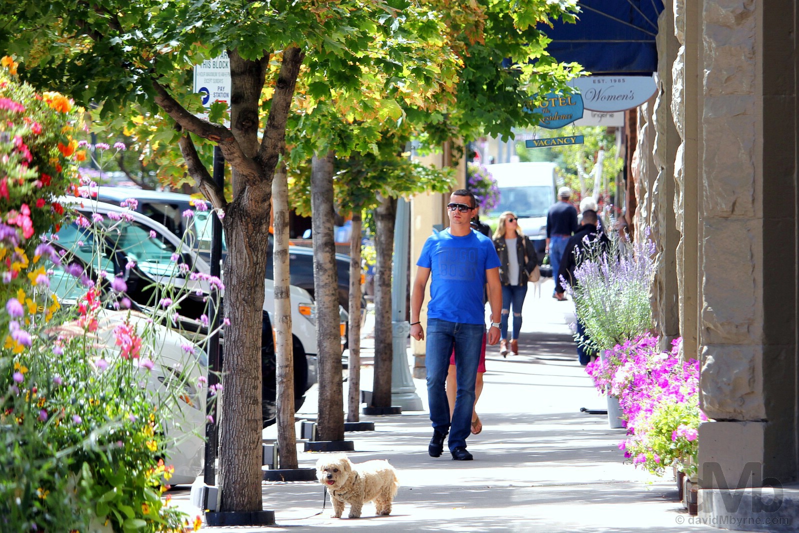
I was really looking forward to visiting the swish skiing town and celebrity magnet of Aspen but, and as it turned out, the drive there and back from Leadville was more of a highlight, if you’ll pardon the pun, than the destination itself. Save for sitting around in expensive cafes and restaurants or spending fortunes in designer boutiques, there’s not a whole lot to do in the town, at least not at this time of year (of course with the addition of snow, I’d imagine it’s a totally different story come winter). It’s a pretty place – there are a lot of in-bloom trees, hanging baskets and flower beds in summertime Aspen – but at the same time it is a bit sterile and it feels every bit as pretentious as it looks. We snooped around for while, long enough to get a feel for the place. The town has a population of just under 7,000, most of whom seem to be doing OK; the town boasts some of the most expensive real estate prices in the US and a spot of window shopping (it seems every second business is a Real Estate) reveals some rather eye-popping property prices. Aspen, Colorado. September 13, 2016.
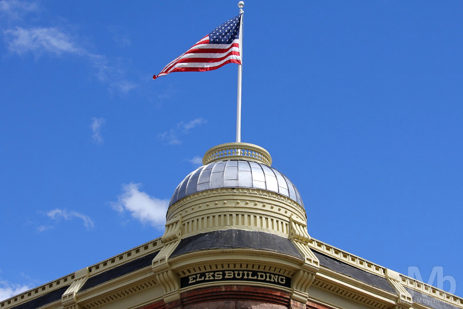
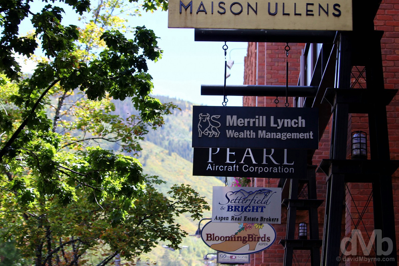
A portion of The Elks Building, one of many historic redbrick silver boom-era buildings still standing in present-day Aspen, Colorado. September 13, 2016.
Retracing our route from Aspen back over Independence Pass to the east of the Continental Divide, it was almost 3 p.m. when we were pulling out of Leadville to continue the drive north. Only 12 miles out of Leadville and we traversed Fremont Pass (11,318 feet, 3,450 metres), the fourth Rocky Mountain Continental Divide Pass we’d encountered in 24 hours, a rather tame affair that didn’t detain us very long. There was nothing tame about the subsequent 64-mile slog from Fremont Pass to the Berthoud Pass; if felt like it was uphill the whole way to Rocky Mountain Pass number 5.
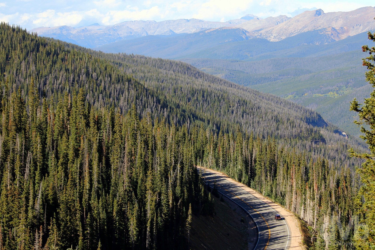
US Route 40 as seen from the Berthoud Pass, north-central Colorado. September 13, 2016.
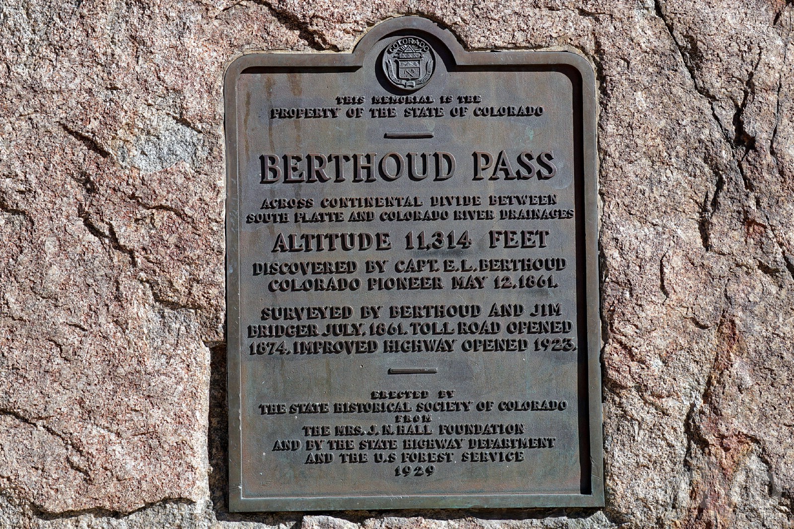
There are two markers atop the Berthoud Pass, one which lists the altitude at 11,307 feet (3,446 metres) and this bronze plaque which not only tacks on another 7 feet but also details some of the history of the Pass. The steep terrain on both sides of the Pass makes it one of the most notoriously difficult passes for motorists in Colorado; there’s a particularly large number of switchbacks on the southern approach to the Pass. An abundance of steep and challenging terrain and plentiful snow also makes this a popular Pass with backcountry skiers, snowboarders and snowshoers. Once home to the now-defunct Berthoud Pass Ski Area (closed in 2002 due to financial problems), a warming hut was opened at the top of the Pass in May 2008 to offer winter shelter to adventurers when needed, something we didn’t find on any other high-altitude Rocky Mountain Pass. Berthoud Pass, north-central Colorado. September 13, 2016.
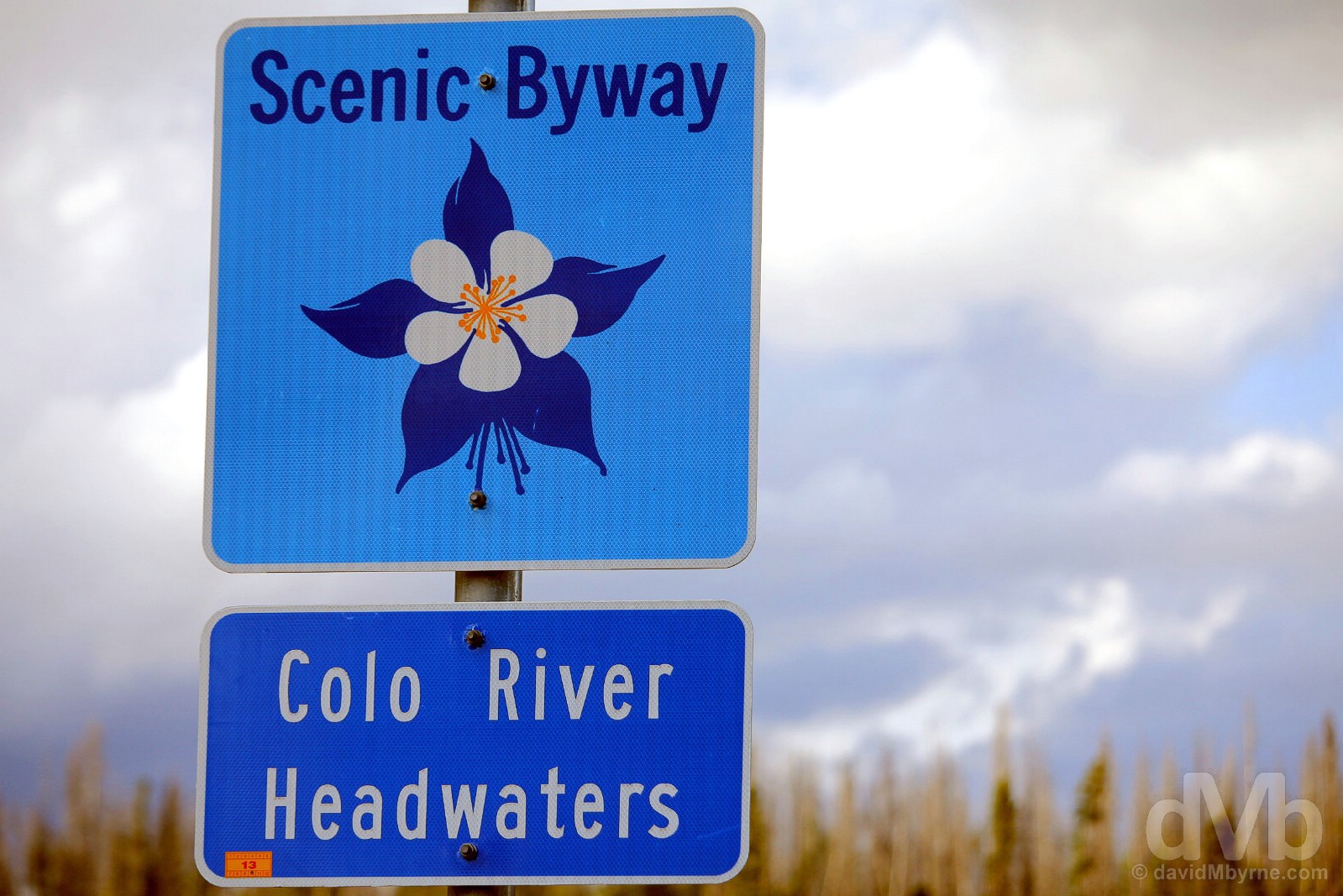
On the Colorado River Headwaters National Scenic Byway of US Route 34 in north-central Colorado. September 13, 2016.
National Scenic Byway #6 – Colorado River Headwaters National Scenic Byway![]()
We only drove a short portion of the Colorado River Headwaters National Scenic Byway, the easternmost 15-mile stretch connecting Granby to Grand Lake at the entrance to Rocky Mountain National Park. The 69-mile Colorado River Headwaters National Scenic Byway continues for another 54 miles west of Granby, via US Route 40 and County Road 1/Trough Road, dropping 1,700 feet (520 metres) in elevation from end to end while following the early course of the famous Colorado River past reservoirs and lush ranch land and through narrow canyons flanked by the railroad. One of the two principle rivers in the Southwest US, the Colorado rises at La Poudre Pass in Rocky Mountain National Park, about 25 miles (40 kilometres) north of Lake Granby, before meandering for 1,450 miles (2,330 kilometres) to the Gulf of Mexico.
We crossed a small bridge over the mighty Colorado, pulled over & went back to the bridge to take a look. Having so recently seen firsthand the river’s might in carving the red sandstone of the US Southwest, most notably the Grand Canyon & Horseshoe Bend, it was awesome to view in this highland region of the country the tame trickle of the mighty Colorado River’s oh-so humble headwaters.
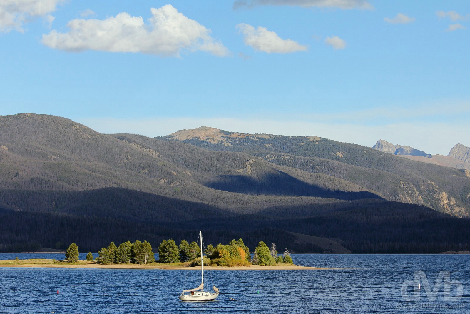
Lake Granby as seen from US Route 34 on the Colorado River Headwaters National Scenic Byway. The third-largest body of water in Colorado, the lake was created by the erection of Granby Dam which was completed in 1950. North-central Colorado. September 13, 2016.
A few miles beyond Lake Granby is Grand Lake at the end of the Colorado River Headwaters National Scenic Byway. It also marked the entrance to the latest National Park of the road trip, the next All-American Road & not one but three more high-altitude Rocky Mountain passes. Unfortunately we didn’t get to see a whole lot of that.
Rocky Mountain National Park
Size: 265,795 acres/1,075 km². Founded: 1915. Annual Visitors: 4.1 million (third-most visited).
It’s no surprise that the Who’s “I Can See for Miles” was on the “Easy Rider” movie soundtrack. It’s an apt road-trip song about the vistas travelers seek. Here, park visitors can appreciate those lyrics by driving the highest paved road in the Park Service. Trail Ridge Road crests at 12,183 feet. It’s designated as an American Byway and All-American Road.
– The Park Service’s “Natural History Handbook Number Three” (1954)
The park’s panoramas also include two bodies of water named on the Wilderness Society’s list of prettiest lakes in wild lands: Mills Lake, which offers high-elevation views of Longs Peak and the Keyboard of the Winds (spires that channel wind into unearthly sounds); and Loch Lake, with views of mountain peaks and Glacier Gorge.
Here in north-central Colorado, vacationers may access 350 miles of trails designed for all levels of ability. Hikers can walk valleys and meadows that were trod by native Utes until the late 1700s. Its later visitors included gold miners, followed by homesteaders and sightseers drawn to the lush environment. Today, the Park Service says the landscape is home to a large variety of animal dwellers, including 60 species of mammals and 270 bird species. The park, which straddles the Western Continental Divide, also has 141 confirmed species of butterflies.
From The Washington Post – The Essential guide to all 59 U.S. national parks.
National Park #7 || Rocky Mountain National Park, north-central Colorado. September 13, 2016.
I first noticed the loss of power, the intermittent lack of responsiveness, when driving by the (flat) shores of Lake Granby. Next came the worrying puffs of smoke quickly followed by the equally worrying clicking noise coming from the transmission. We had problems with the Hyundai Accent. The timing couldn’t have been much worse as we were just about to begin the 20-mile, 4,000-feet (1,220 metre) ascent to the 12,183 feet (3,713 metre) crest of Rocky Mountain National Park’s All-American Trail Ridge Road/Beaver Meadow Road, only America’s highest continuously paved road. Needless to say it was an ascent that would do little to improve the condition of the ailing Accent. But with few options we pushed on hoping we’d make it up one side and that gravity and luck would combine to get us down the other.
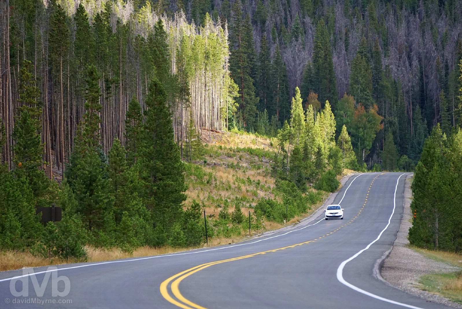
When we limped into Rocky Mountain National Park’s Kawuneeche Valley, just beyond the park’s Grand Lake Entrance Station, it was late in the day. The light was fading, the sun fleeting & the conditions ahead looked gloomy. Having just entered the park boundary I pulled over to capture this image at the start of the All-American Trail Ridge Road/Beaver Meadow Road of US Route 34 passing through the scenic valley. In hindsight I was right to assume it would be one of the few pictures I captured in the National Park as conditions did deteriorate the further we continued into the park and the higher we got on the park’s rising and cloud-enveloped Trail Ridge Road/Beaver Meadow Road. Kawuneeche Valley, Rocky Mountain National Park, Colorado. September 13, 2016.
All-American Road #4 – Trail Ridge Road/Beaver Meadow Road![]()
The All-American Trail Ridge Road/Beaver Meadow Road is Rocky Mountain National Park’s heavily travelled highway to the sky. Completed in the early 1930s and named ‘Trail Ridge Road’ given its proximity to historic pathways used by native peoples to cross the Rocky Mountains, the road traverses the park for 48 miles (77 kilometres) from Grand Lake to Estes Park. Topping out at 12,183 feet (3,713 metres) makes this the highest continuously paved road in the US. Eleven miles of the route roam above the treeline at an elevation of near 11,500 feet (3,505 metres) where the park’s montane evergreen forests give way to an alpine tundra environment, a windswept alpine world where conditions are said to resemble those found in the Canadian or Alaskan Arctic. It would have been nice to experience some of that, but as it was we could scarcely see where the treeline ended and the alpine tundra environment began.
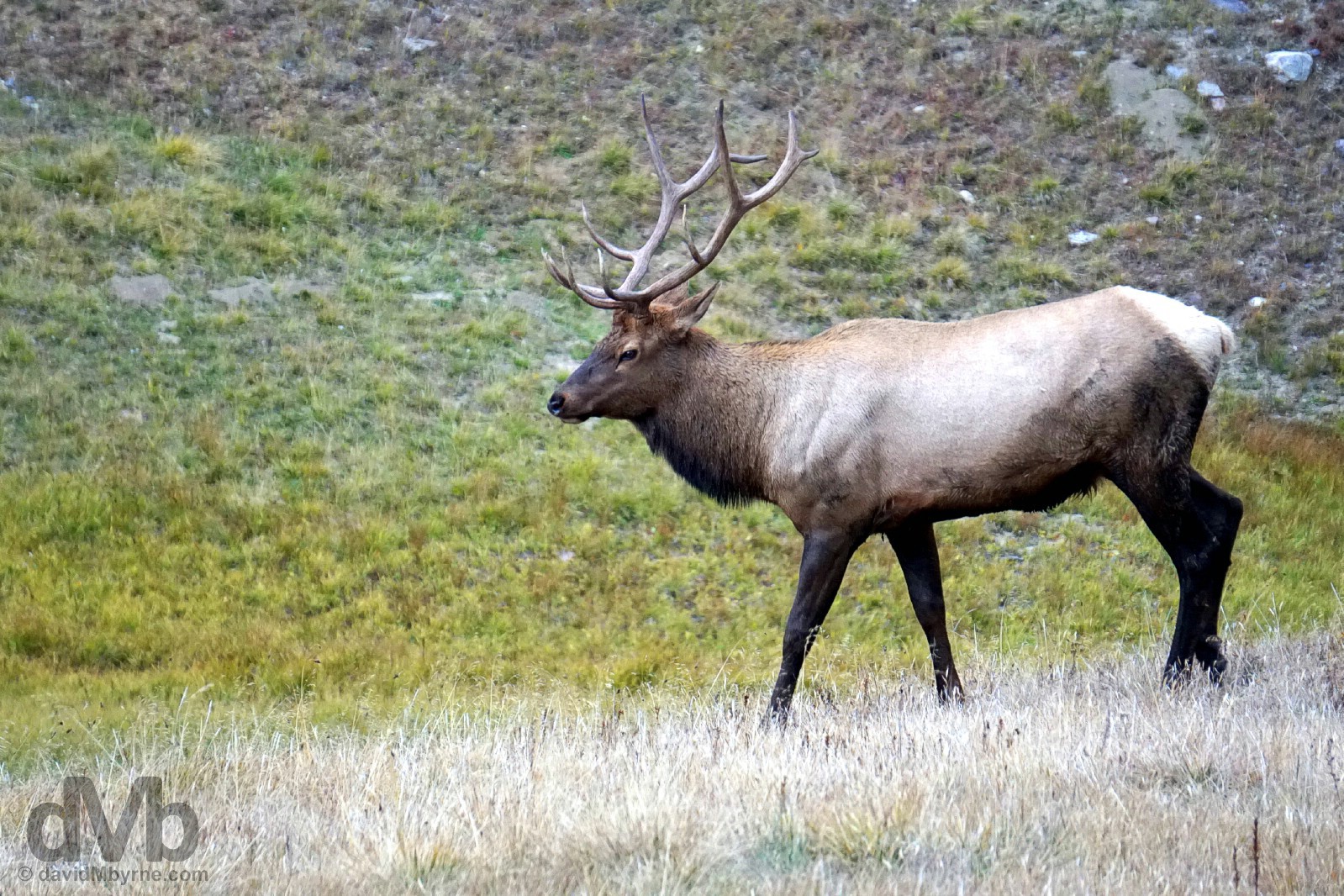
Wildlife on Milner Pass as seen from the All-American Trail Ridge Road/Beaver Meadow Road of US Route 34 in Rocky Mountain National Park, Colorado. September 13, 2016.
– The US National Park Service
After ascending to the 10,758-feet (3,280-metre) Milner Pass, 16 miles from the Grand Lake Entrance Station, we continued on the Trail Ridge Road/Beaver Meadow Road through both Fall River Pass (11,796 feet, 3,595 metres), 4 miles further on, & Iceberg Pass (11,827 feet, 3,605 metres), a further 3 miles on. In the process we crossed over the 12,183-feet (3,713-metre) crest of the route, the so-called Trail Ridge. Located 22 miles from the Grand Lake Entrance Station, it was to be the highest of all our Rocky Mountain highs of the past few days, not that we even noticed it – we didn’t. Our ailing ride aside, we did stop at a few of the numerous & obvious overlooks along course of the road, none of which offered the advertised ‘thrilling views’ thanks, of course, to the all-enveloping cloud cover; even in the best of conditions we’d probably still have been just as preoccupied with getting our ailing car to the perceived sanctuary of Estes Park as we were today when vista visibility was nonexistent.
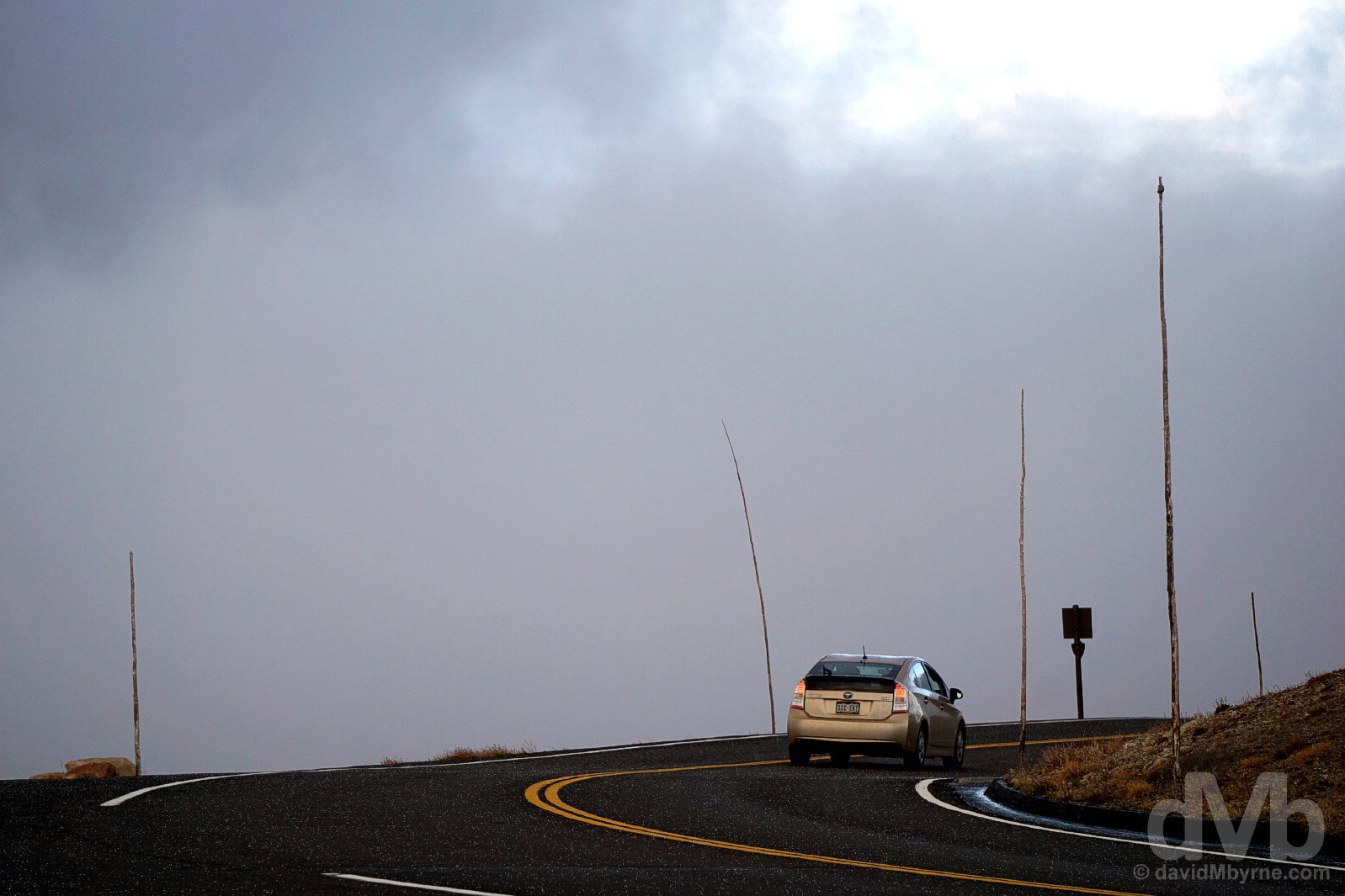
On the cloud-enveloped All-American Trail Ridge Road/Beaver Meadow Road of US Route 34 in Rocky Mountain National Park, north-central Colorado. September 13, 2016.
We did make it into Estes Park. A 24-mile descent from Trail Ridge, this is a popular summer resort town and the eastern access point for Rocky Mountain National Park. The call to Hertz this evening after arrival was interesting. We told them the diagnostics, not feeling the need to divulge the fact that we’d driven the Hyundai Accent for 4,890 miles over the past 17 days, the past two days of which have seen us make 10 ascents over 8 different 10,000-plus feet Rocky Mountain Passes. Immaterial details. It’s debatable whether the car will start in the morning, Epic US Road Trip day 18 and a day we will somewhat ironically descend from the hills down onto the Great Plains of the very flat US heartland. If the car does start we’ll drive to a rental depot for an exchange. If it doesn’t Hertz will come to us. Either way we’ll have a new ride for the remainder of the road trip.
The Accent wouldn’t start so Hertz did come to us, swapping an ailing graphite hatchback Accent for a working silver saloon Accent. We lost the morning but gained a tad more space we don’t need. Here’s hoping this Accent can last the pace.
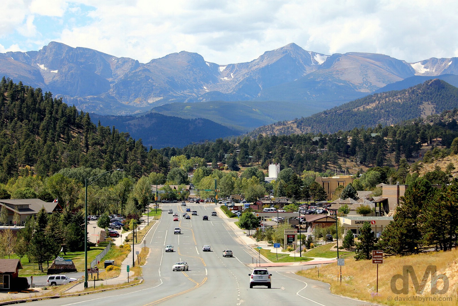
It looks like we arrived in Estes Park a day early. It was a beautiful day today, a great day to be heading for the heights of Rocky Mountain National Park. We’re not. For the first time in days we’re descending. We’ve had our highs. Estes Park, north-central Colorado. September 14, 2016.
THE UPPER MIDWEST || Wisconsin & Minnesota
DAY 01 139 miles || Chicago’s O’Hare Airport to Madison, Wisconsin
DAY 02 302 miles || Madison to Saint Paul, Minnesota (via Pewit’s Nest State Natural Area & Prescott, Wisconsin)
DAY 03 259 miles || Saint Paul to Bemidji, Minnesota (via St Cloud, Brainard & Walker, Minnesota)
THE DAKOTAS || North & South Dakota
DAY 04 458 miles || Bemidji to Bismarck, North Dakota (via Grand Forks, Lakota & Rugby, North Dakota)
DAY 05 459 miles || Bismarck to Deadwood, South Dakota (via Fort Yates, North Dakota & Badlands National Park, South Dakota)
DAY 06 167 miles || Deadwood & The Black Hills (Mount Rushmore National Memorial & Crazy Horse Memorial)
THE NORTHERN ROCKIES || Wyoming, Montana & Idaho
DAY 07 354 miles || Deadwood to Billings, Montana (via Devil’s Tower & Little Bighorn Battlefield National Monuments)
DAY 08 262 miles || Billings to West Yellowstone, Montana (via the Beartooth Highway & Yellowstone National Park)
DAY 09 227 miles || West Yellowstone to Jackson, Wyoming (via Yellowstone National Park & Grand Teton National Park)
DAY 10 280 miles || Jackson to Salt Lake City, Utah (via Alpine, Wyoming; & Montpelier, Paris, & Bear Lake, Idaho)
THE SOUTHWEST || Utah, Arizona & New Mexico
DAY 11 330 miles || Salt Lake City to Panguitch, Utah (via Brian Head & Cedar Breaks National Monument)
DAY 12 273 miles || Panguitch to Page, Arizona (via Bryce Canyon National Park, & Zion National Park)
DAY 13 307 miles || Page (Horseshoe Bend) & Grand Canyon National Park (North Rim)
DAY 14 175 miles || Page to Kayenta, Arizona (via Upper Antelope Canyon, Arizona & Monument Valley, Utah)
DAY 15 252 miles || Kayenta to Durango, Colorado (via Monument Valley, Utah, the Four Corners Monument, & New Mexico)
THE ROCKIES || Colorado
DAY 16 348 miles || Durango to Leadville, Colorado (via Wolf Creek Pass & Monarch Pass)
DAY 17 299 miles || Leadville to Estes Park, Colorado (via Independence Pass, Aspen, Berthoud Pass, & Rocky Mountain National Park)
THE GREAT PLAINS || Wyoming, Nebraska, Iowa, Missouri & Arkansas
DAY 18 307 miles || Estes Park to Cheyenne, Wyoming (via Laramie, Como Bluff, Medicine Bow, & Buford, Wyoming)
DAY 19 404 miles || Cheyenne to Burwell, Nebraska (via Scotts Bluff National Monument & Carhenge, Nebraska)
DAY 20 407 miles || Burwell to Kansas City, Missouri (via Spalding, Nebraska; SW Iowa; & Omaha, Nebraska)
DAY 21 286 miles || Kansas City to St Louis, Missouri
DAY 22 322 miles || St Louis to Memphis, Tennessee (via Dyess, Arkansas)
THE SOUTH || Tennessee, Mississippi, Alabama & Georgia
DAY 23 308 miles || Memphis to Vicksburg, Mississippi (via Clarksdale, Yazoo City & Bentonia, Mississippi)
DAY 24 336 miles || Vicksburg to Prattville, Alabama (via Selma, Alabama)
DAY 25 297 miles || Prattville to Cornelia, Georgia (via Montgomery, Alabama & Stone Mountain, Georgia)
THE APPALACHIANS || Georgia, North Carolina, Virginia & West Virginia
DAY 26 261 miles || Cornelia to Asheville, North Carolina (via Helen & Brasstown Bald, Georgia & Great Smoky Mountains National Park, North Carolina)
DAY 27 200 miles || Asheville to Galax, Virginia (via the Blue Ridge Parkway)
DAY 28 004 miles || Galax, Virginia
DAY 29 354 miles || Galax to Lewisburg, West Virginia (via the Blue Ridge Parkway & Shenandoah National Park)
KENTUCKY & THE GREAT LAKES || Ohio, Kentucky, Indiana & Illinois
DAY 30 404 miles || Lewisburg to Lexington, Kentucky (via Chesapeake, Ohio; Cordell, Kentucky; & Sandy Hook, Kentucky)
DAY 31 241 miles || Lexington to Beaver Dam, Kentucky (via Lincoln Homestead State Park & Mammoth Cave National Park)
DAY 32 190 miles || Beaver Dam to Bloomington, Indiana (via Rosine & Owensboro, Kentucky)
DAY 33 282 miles || Bloomington to Chicago, Illinois (via Indianapolis, Indiana)
DAYS 34-36 017 miles || Chicago, Illinois