US ROAD TRIP 2018
Bite-sized USA.“It may not have been as epic in scale as what’s gone before it, necessitating the omission of the word ‘epic’ from the road trip title, but this stateside jaunt was epic for other reasons, least of all the company. US Road Trip 2018 was a bite-sized US family affair.”
Image || Day 4. On a wooded section of the Skyline Drive in Shenandoah National Park, Virginia. October 2, 2018.
US Road Trip 2018 Introduction
Here we go again. We hadn’t initially planned a 2018 US Road Trip, hadn’t planned on adding to the 16,634 odometer miles clocked over the course of the 69 days of our recent Epic US Road Trips in 2016 & 2017. But this little US filler was different. It was kinda the same, but still different – the same in that we largely covered familiar ground, different in that we weren’t alone. It may not have been as epic in scale as what’s gone before it, necessitating the omission of the word ‘epic’ from the road trip title, but this stateside jaunt was epic for other reasons, least of all the company. US Road Trip 2018 was a bite-sized US family affair.
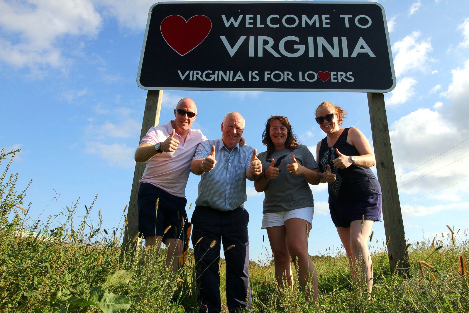
Virginia is for lovers… and US road-trippin’ families. At the Virginia/Maryland state line on US Route 13 on the Delmarva peninsula, New Church, Virginia. Day 9. October 7, 2018.
– Lonely Planet
dMb's Country Overview - USA
 United States of America
Region – North America (dMb tag: North America). Capital – Washington DC. Population – 326 million Americans (the world’s third-most populous country). Official Language – None (at federal level) although American English is the national language. Currency – USD, US Dollar ($). GDP (nominal) per capita – US$59,000. Political System – Federal presidential constitutional republic. UN Member? – Yes (founding member admitted November 1945 & one of the five permanent members of the UN Security Council). G20 Member? – Yes. Size – 9,830,000 km² (the world’s third-largest country by land area – after Russia & China – is fractionally smaller than the continent of Europe). Topography – Extremely diverse. Climate – Ditto. Brief History & Today – Populated for at least 15 millennia, Europeans first arrived in North America in the 16th Century with the country as we know today emerging from the so-called Thirteen Colonies, the 13 colonies of the North American East Coast settled by the British between 1607 & 1732. The end of the American Revolutionary War in 1783 saw the US becoming the first country to gain independence from a European power, not to mention the eventual ushering in of the seminal US Constitution. Having banished the Brits, less than a century later the Americans felt the need to fight among themselves with the antislavery Yankees of the North prevailing over the slave advocating Confederate States of Dixie, the South, in the bloody US Civil War (1861-1865). Aggressive expansion continued, migration across the Great Plains into the West leading to conflict with Plains Indians, native inhabitants who lost so much to the white man’s expansionist needs. Although World War I confirmed the country’s status as a global military power, the country was to emerge from World War II as the world’s first (& today only) global superpower. Still a worldwide champion – for good or bad – of the very same democratic principles the country was founded on, today the US remains a global trendsetter and a leading political, cultural and scientific force internationally. UNESCO World Heritage sites – 23. Tourism Catchphrase/Slogans – All Within Your Reach. Famous For – Lots of things, good & bad, but mainly for influence & for being a pop cultural behemoth & trendsetter; most worldwide fads, everything from music to media to fashion, originate in the US. Highlight – A road trip just about anywhere. Options are endless on the world’s longest & biggest road network. US Titbits – The word America is attributed to German cartographer Martin Waldseemüller who produced a world map in 1507 on which he named the lands of the Western Hemisphere ‘America’ after the Italian explorer and cartographer Amerigo Vespucci… the 50 states, federal district, 5 self-governing territories & various possessions of the US are spread across 9 time zones, the country’s extreme diversity in geography, climate and wildlife making it both one of the world’s 17 megadiverse countries (the US has the most ecoregions out of any country in the world) and easily the world’s best road-trippin’ destination… the world’s largest importer and second-largest exporter of goods, the US is an economic juggernaut whose economy, the world’s largest, accounts for approximately a quarter of global GDP (over 30% of the world’s wealth resides in the US even though it accounts for a little over 4% of the world’s population)… the US is the only country to have landed a man on the moon & was the first country to develop nuclear weapons (although it is infamously the only nation to have used them in warfare) – its spending on military alone accounts for a whole one-third of global military spending… the US is one of only 3 countries in the world not to use the metric system as the official system of measurement (the other two being Liberia & Myanmar, a.k.a. Burma).
– Lonely Planet USA, 6th edition
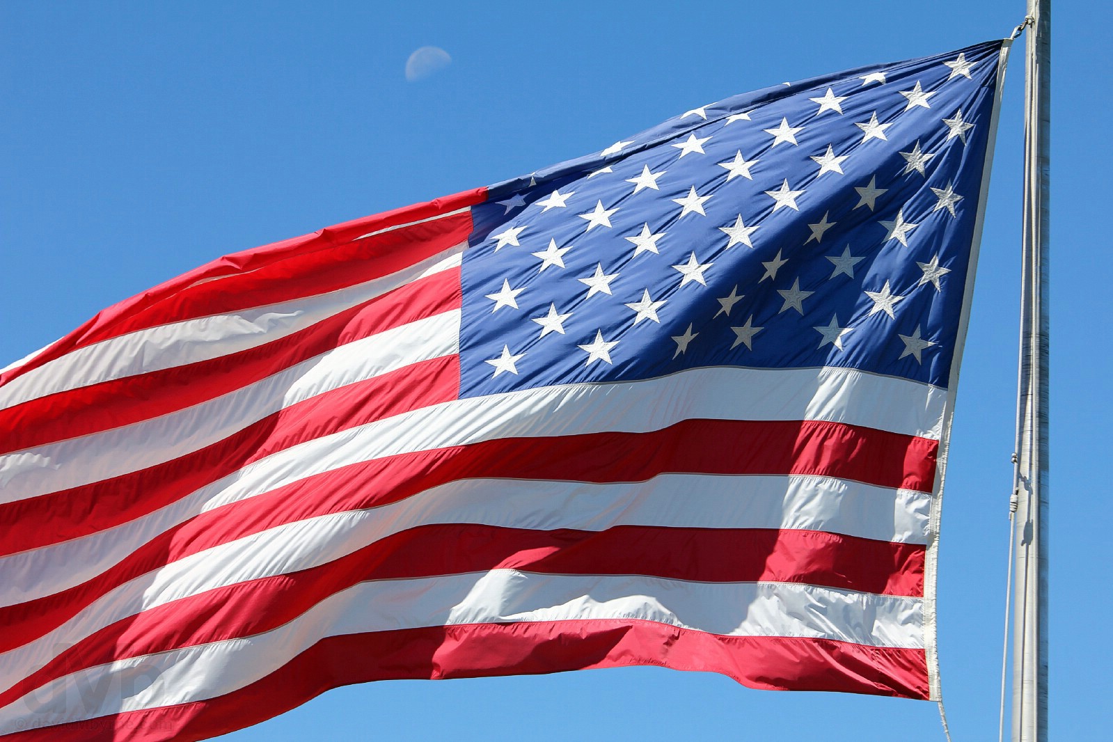 The current American flag flying atop the viewing deck of the Brasstown Bald Visitors Center in Hiawassee, northern Georgia. September 22, 2016.The country’s greatest symbol, the 50 stars & 13 stripes of the US flag – a.k.a. the Stars & Stripes, Old Glory or the Star-Spangled Banner – represent, respectively, the 50 states of the Union and the original 13 British colonies that became the first US states. The original 13-star version was adopted in 1777, a year after the US Declaration of Independence. The current 50-star version has been the official US flag since Independence Day 1960 – change was needed when Hawaii, the 50th state & thus 50th star, was added to the Union in 1959. It was designed in 1958 as a school project by 17-year-old Robert Heft. He got a B-.
Visits – First visit June 1998. Numerous visits since.
US Road Trip 2018 In Numbers
Days
Miles Driven
US States
National Park Visited
National Scenic Byway & All-American Roads Driven
US Road Trip 2018 Day-by-Day Overview
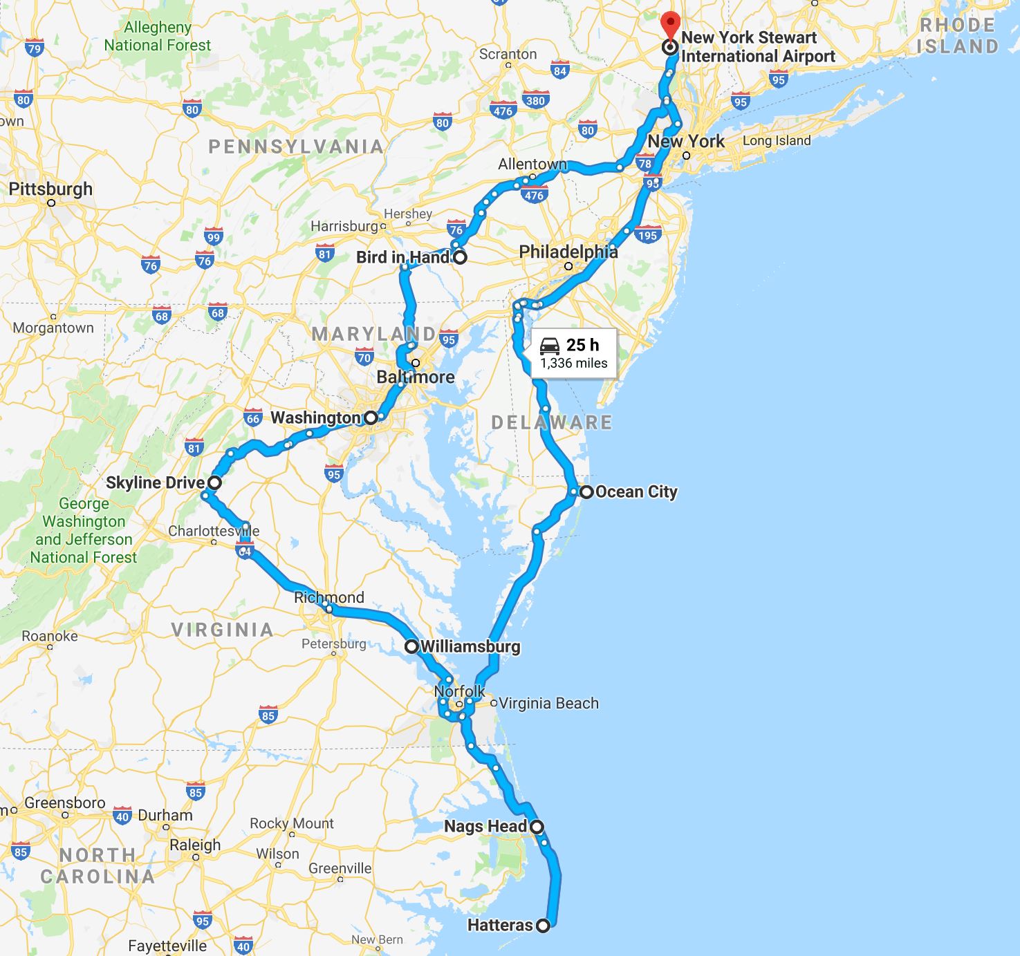
DAY 01 253 miles (407 km) || New York Stewart International Airport to Lancaster, Pennsylvania
DAY 02 161 miles (259 km) || Lancaster to Washington D.C.
DAY 03 86 miles (138 km) || Washington D.C. to Front Royal, Virginia
DAY 04 263 miles (423 km) || Front Royal to Williamsburg, Virginia
DAY 05 165 miles (266 km) || Williamsburg to Nags Head, Outer Banks, North Carolina
DAYS 06-08 165 miles (266 km) || Nags Head, Outer Banks, North Carolina
DAY 09 230 miles (370 km) || Nags Head to Ocean City, Maryland
DAY 10 324 miles (521 km) || Ocean City to New York Stewart International Airport
Daily Entries
Image || Crossing the Delaware River from Pennsylvania to New Jersey via the Historic Dingman’s Ferry Bridge.
“We hadn’t planned on being distracted en route from Stewart International Airport to our overnight location of Lancaster in the heart of Pennsylvania’s Amish Country. But road trips have a habit of distracting. Que one historic bridge & one epic tailback.”
Day 1 || September 29 2018
Route || New York Stewart International Airport to Lancaster, Pennsylvania.
Miles (Kilometres) Driven || 253 (407)
Today’s Highlight || The Historic Dingman’s Ferry Bridge
We packed a lot into 24+ hours of day 1 activity, an early-to-rise-late-to-fall day if ever there was one. A transatlantic flight followed by a 253-mile (407 kilometre) adventure that included another New Jersey failure; an historic toll bridge; three states & two state lines; (only) one missed turn; & one epic tailback, the kind of jam the US east does rather well. It was good to be back.
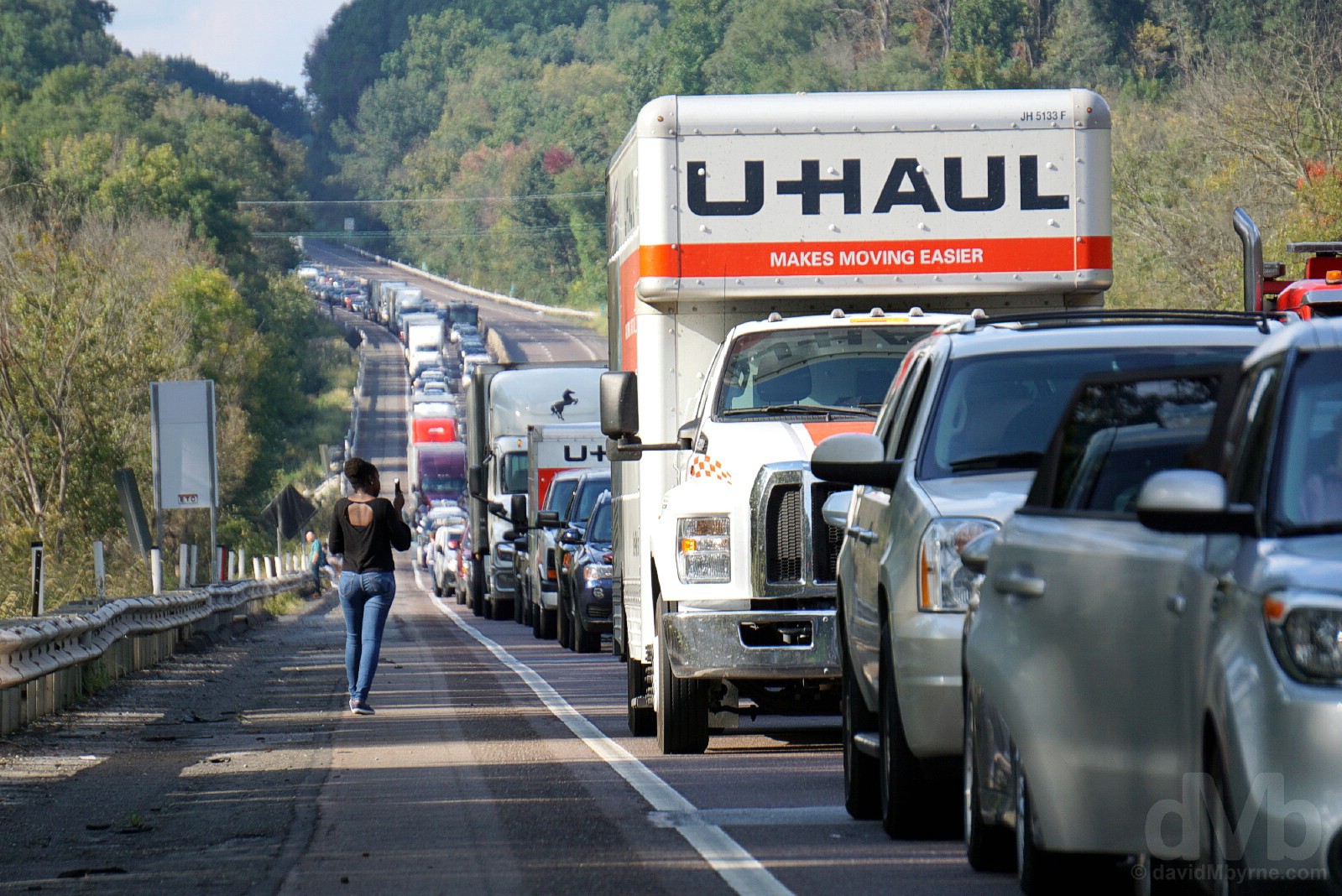
One of the slower parts of the day. Epic tailback heading south on Interstate 476, Pennsylvania. September 29, 2018.
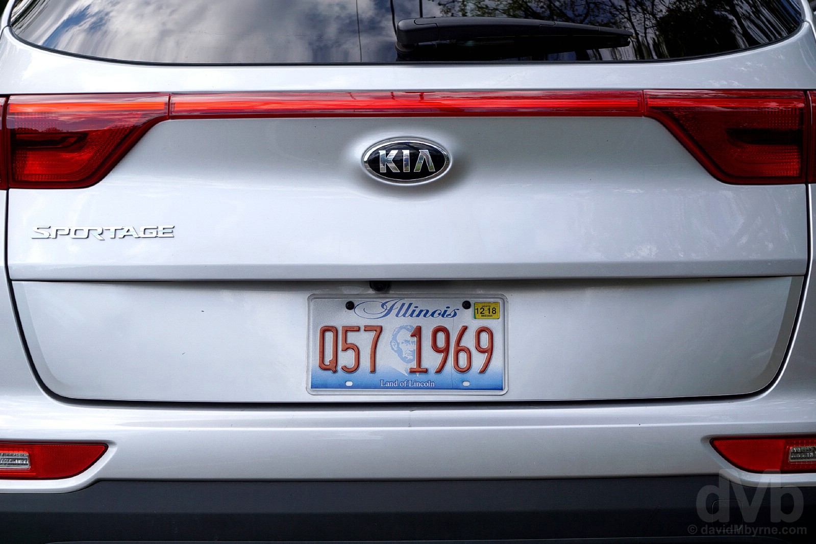
2018 STEED || Our 2018 US Road Trip steed. New York Stewart International Airport, Orange County, New York. September 29, 2018.
An Illinois-registered Kia, just like our 36-day, 26-state, 9,510-mile Epic US Road Trip 2016 steed, at least until such time as it – the poor thing – succumbed to Colorado Rocky Mountain highs. No such toils for this year’s ride meaning it saw it through to the bitter end.
We hadn’t planned on being distracted en route from Stewart International Airport to our overnight location of Lancaster in the heart of Pennsylvania’s Amish Country. But road trips have a habit of distracting. Cue one historic bridge & one epic tailback.
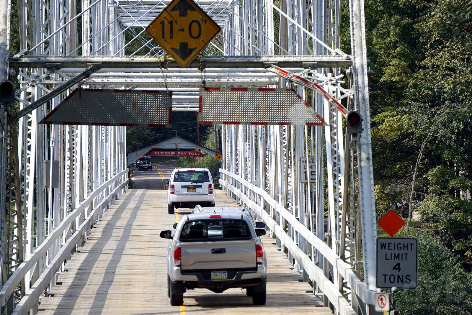
DINGMAN’S FERRY BRIDGE || The Historic Dingman’s Ferry Bridge spanning the Delaware River as seen from Sandyston Township, New Jersey. September 29, 2018.
We weren’t relishing the idea of crossing over into the dirty Jerz, probably our least favourite of all the US states. We could have easily avoided doing so, but thought maybe a brief crossing from Pennsylvania over the mighty Delaware River (which acts as a natural boundary between the two states) would give us the opportunity to capture the NJ state line picture we failed to capture after many attempts last year. No such luck in what was just the latest New Jersey letdown, but we did at least get to cross the Historic Dingman’s Ferry Bridge. Connecting Pennsylvania’s Delaware Township with New Jersey’s Sandyston Township, the present-day 2-lane 530-feet-long (160 metre) bridge is one of the last few privately owned toll bridges in the US and the last remaining privately owned toll bridge on the Delaware River – it’s $1 to cross in each direction, although it’s free for all on Christmas Day and, as per its charter, free passage is afforded to ‘churchgoers, schoolchildren, and funeral processions’ at any time. It’s named after an Andrew Dingman who, in 1735, was the first to operate a ferry service across the river at this point. The first bridge, constructed by the Dingman’s, was built in 1836 – the present wrought iron truss structure with wooden roadway opened in 1900 and is the 4th iteration of the bridge, and a rather photogenic one at that.

TAILBACK || Downtime during an epic tailback heading south on Interstate 476, Pennsylvania. September 29, 2018.
The reward for missing a junction was to almost immediately find ourselves in a bit of a jam. A serious incident further ahead necessitated helicopter intervention to airlift the casualties which stopped traffic in both directions on Pennsylvania’s busy Interstate 476. We didn’t move for quite some time which gave us ample opportunity to chat with fellow discommoded locals about our good fortune in missing the junction for the 222.
Image || The Reflecting Pool of The National Mall as seen from the steps of the Lincoln Memorial, Washington D.C.
“The sun was out, the heat was on, the sky was blue & the city’s blindingly-white neoclassical marble monuments resplendent. Dare I say it, but Washington D.C. may just have dazzled even more today than it did on this exact same Sunday one year ago.”
Day 2 || September 30 2018
Route || Lancaster, Pennsylvania to Washington D.C.
Miles (Kilometres) Driven || 161 (259)
Today’s Highlight || The National Mall, Washington D.C.
It was a Sunday so it was no surprise that The Amish of Pennsylvania’s Amish Country were quiet: the Bird-in-Hand Farmer’s Market was closed; there were very few of the distinctive black Amish horse-drawn buggies sharing the roads; and there were no families working the land to such photogenic effect as we captured last year. But that’s OK because a quiet Amish Country, where we started the day, meant more time for Washington D.C., where we finished it. The sun was out, the heat was on, the sky was blue & the city’s blindingly-white neoclassical marble monuments resplendent. Dare I say it, but Washington D.C. may just have dazzled even more today than it did on this exact same Sunday one year ago.
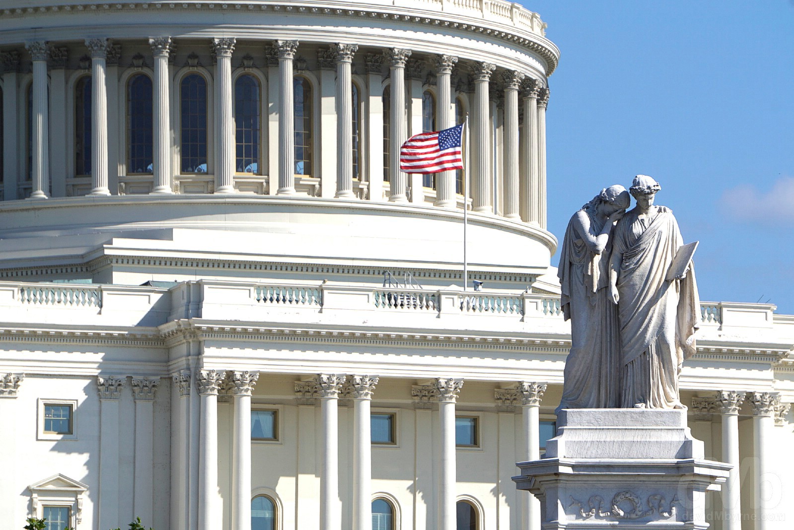
Dazzling. Fronting the United States Capitol building in Washington D.C. September 30, 2018.
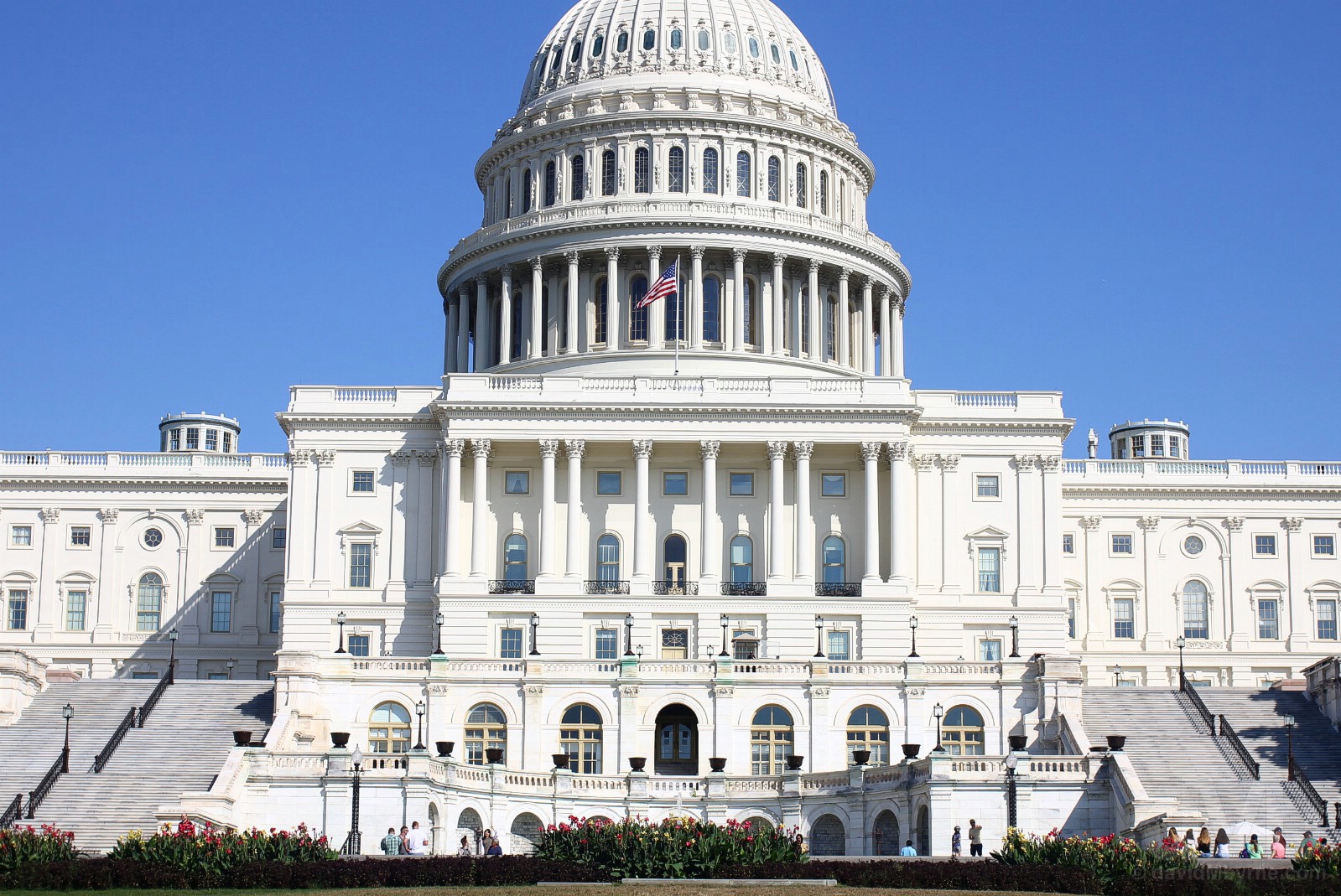
UNITED STATES CAPITOL || Looking resplendent, save for an ugly skin of scaffolding covering the bronze Statue of Freedom at the apex of the famous cast-iron dome, the hulking United States Capitol building, hosting the legislative branch of the US government (Congress), at the eastern end of the National Mall in Washington D.C. September 30, 2018.
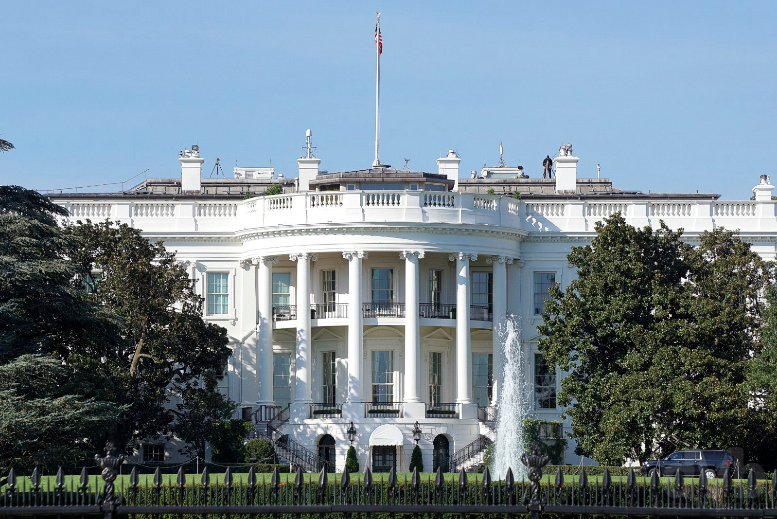
WHITE HOUSE || Having peered at the less-photographed northern facade last year, this year we got as close as we could to the southern facade of the White House, with its famous semi-circular portico of 6 Ionic columns seen here from The Ellipse, the green expanse separating Washington’s most famous facade from the National Mall. September 30, 2018.
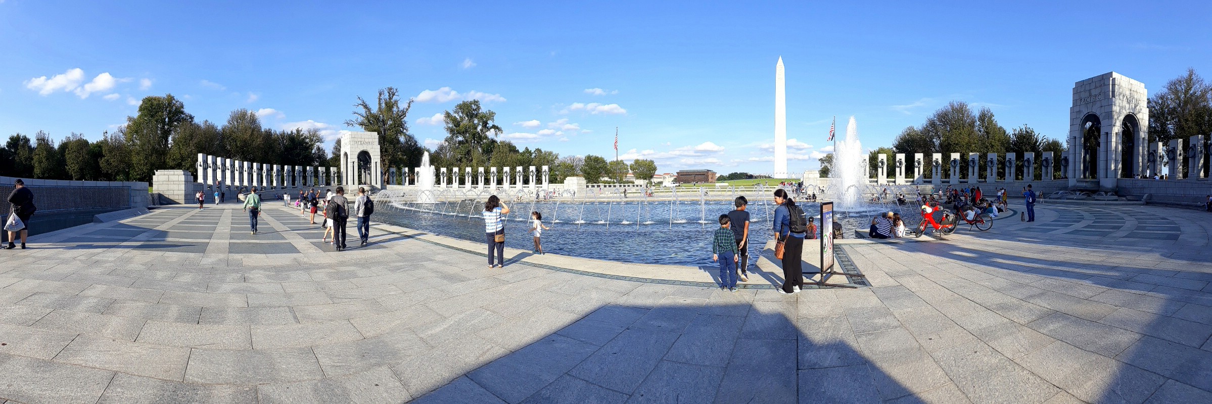
NATIONAL WORLD WAR II MEMORIAL || The World War II Memorial of the National Mall in Washington D.C. September 30, 2018.
The National Mall’s National World War II Memorial, sitting in the middle of the Mall between the towering Washington Monument & the Reflecting Pool, was dedicated in 2004 making it one of Washington’s newest memorials. Dedicated to the Americans who served in the armed forces during the largest and deadliest war in human history, the memorial’s massive oval-shaped 337-feet-long (102 metre) plaza is centered by a fountain and is bordered by 56 17-feet-tall (5.2 metre) pillars (representing the 48 US states, the District of Columbia and the 7 US overseas territories at the time of the war). The whole shebang, bookended by a pair of small triumphal arches (one inscribed ‘Pacific’ the other ‘Atlantic’), is prime panorama territory.
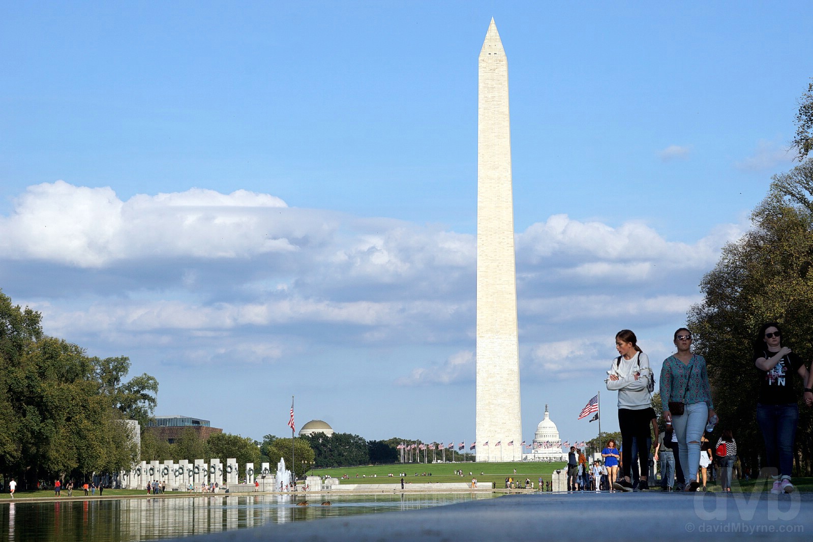
The Washington Monument, the world’s tallest stone structure & tallest obelisk, & the cupola of the United States Capitol building as seen from the edge of the Reflecting Pool of the National Mall, Washington D.C. September 30, 2018.
– Washington.org
Image || The United States Marine Corps War Memorial, Arlington, Virginia.
“I vividly remember walking the 2-mile distance from the National Mall to the United States Marine Corps War Memorial in 1998. Closed this time last year as part of a extensive $5 million refurbishment, the first since its erection in 1956, I was happy to find it open today (& to be able to drive to it), our final stop before leaving the D.C. region for the cooler Appalachian hills of western Virginia.”
Day 3 || October 1 2018
Route || Washington D.C. to Front Royal, Virginia
Miles (Kilometres) Driven || 86 (138)
Today’s Highlight || National Museum of Natural History
It’s – wow – 2 decades (1998) since I last set foot inside the educational walls of a world-renowned Washington D.C. Smithsonian museum. There are more than a few to choose from – in the D.C. region alone, the Smithsonian Institution, a globally prestigious research unit established in 1846 “for the increase and diffusion of knowledge” and administered today by the US Government, oversees 17 (free) world-class museums, galleries, gardens & even a zoo (2 more Smithsonian museums in New York City help make the Smithsonian the largest museum complex on earth). The National Air and Space Museum, one of 11 Smithsonian museums & galleries located on the National Mall between the Washington monument & the United States Capitol, pulls the biggest crowds (it’s the most popular museum in the US, the third most visited on earth & the museum I visited back in 1998), but today we paid a visit to the no-less-fascinating innards of the National Museum of Natural History. It was the highlight of another awesomely photogenic day in Washington D.C.
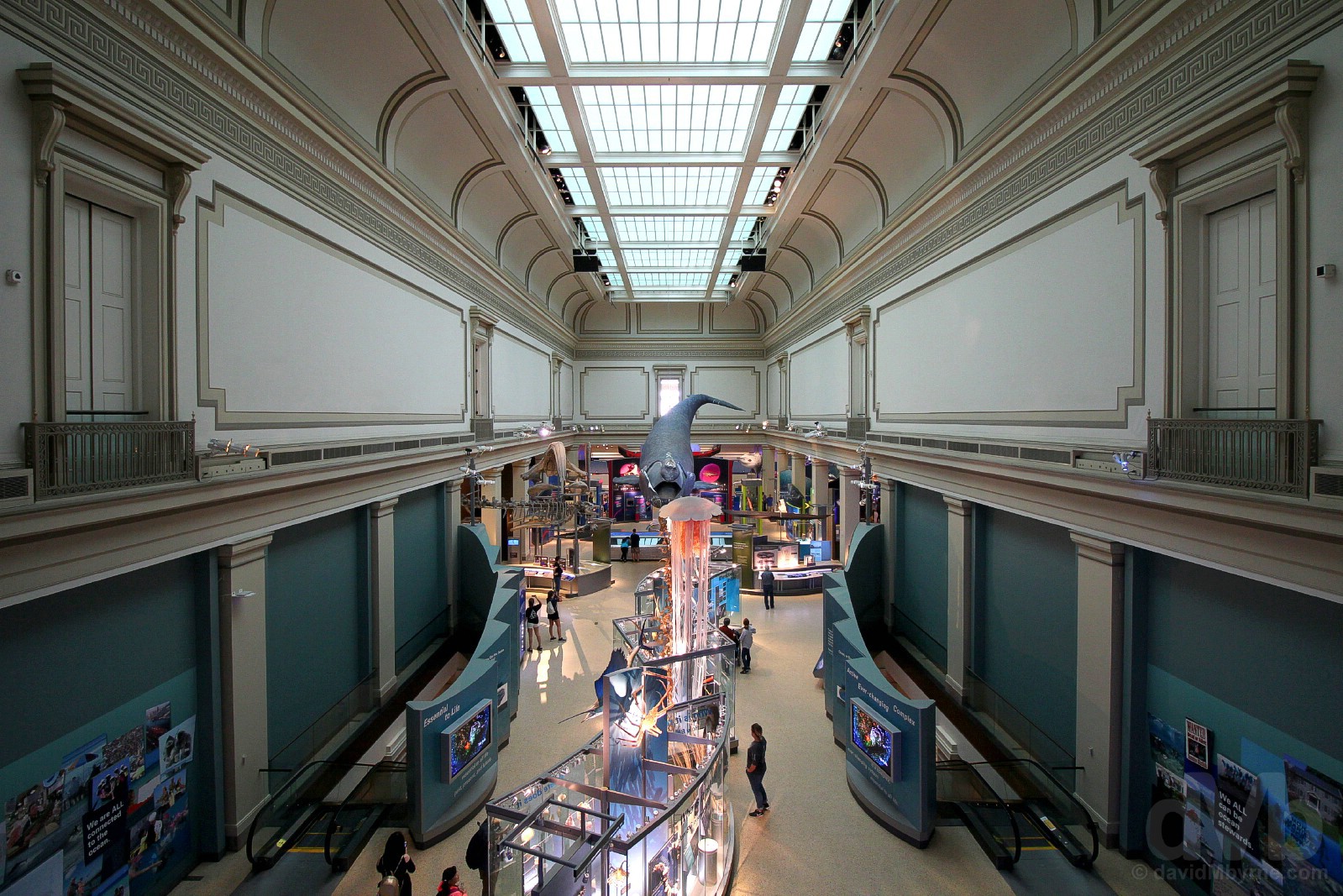
Ocean Hall. The National Museum of Natural History, Washington D.C. October 1, 2018.
– https://naturalhistory.si.edu/
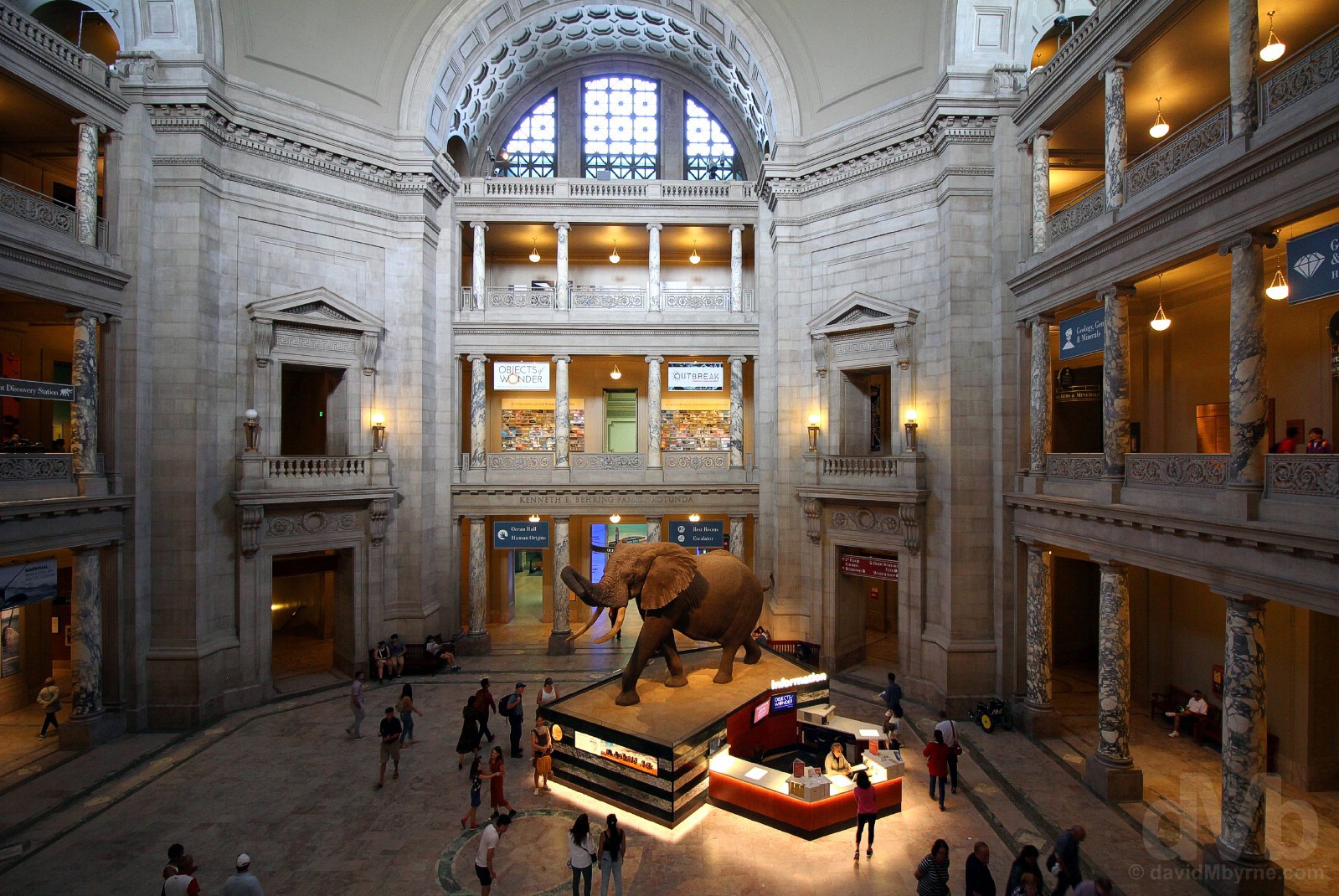
NATIONAL MUSEUM OF NATURAL HISTORY || The rotunda of the National Museum of Natural History, Washington D.C. October 1, 2018.
With free access to the public for 364 days of the year, Washington’s National Museum of Natural History pulls in some 7 million visitors a year. That’s sufficient footfall to give it the title of the most visited natural history museum on earth, and to place it high on the Top 10 list of the world’s most visited museums. Opened since 1910, the museum is housed in a building built specifically for the job of displaying a collection of over 127 million plants, animals, fossils, minerals, rocks, meteorites, human remains and human cultural artifacts, all overseen by a staff of 1,000-plus (185 of the museum’s employees are professional natural-history scientists, the largest group of scientists dedicated to the study of natural and cultural history in the world). The museum boasts some 140,000 m² of exhibition space spread over three levels, the nexus of which is the museum’s central rotunda, seen here, easily the building’s defining architectural feature and its most photographed area. The star attraction here since its introduction to the rotunda in 1959 is the museum’s iconic 12-ton, 14-foot-tall African Elephant, probably the most photographed elephant in history.
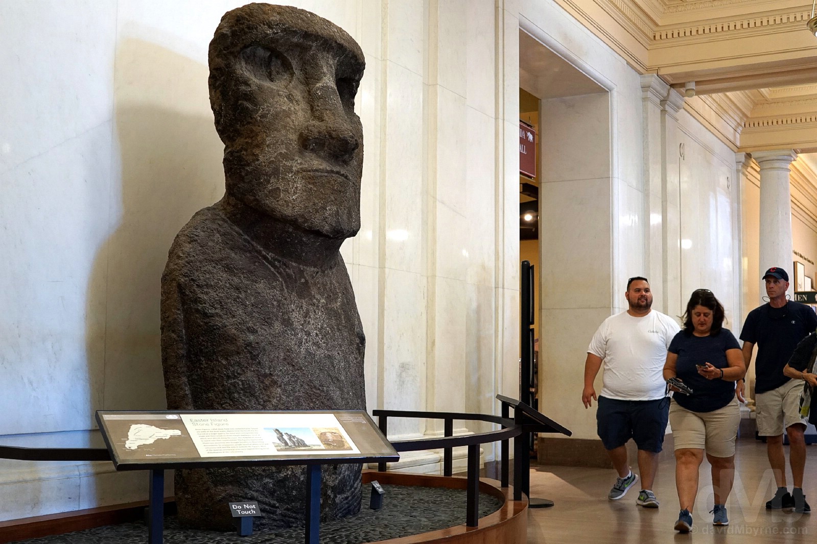
An iconic hardened volcanic ash ancestral figure, or moai, ‘collected’ (that’s the term they use whereas some might deem the term ‘stolen’ more apt) by Paymaster Thomson from Rapa Nui/Easter Island in 1886 and today on display in the National Museum of Natural History, Washington D.C. October 1, 2018.
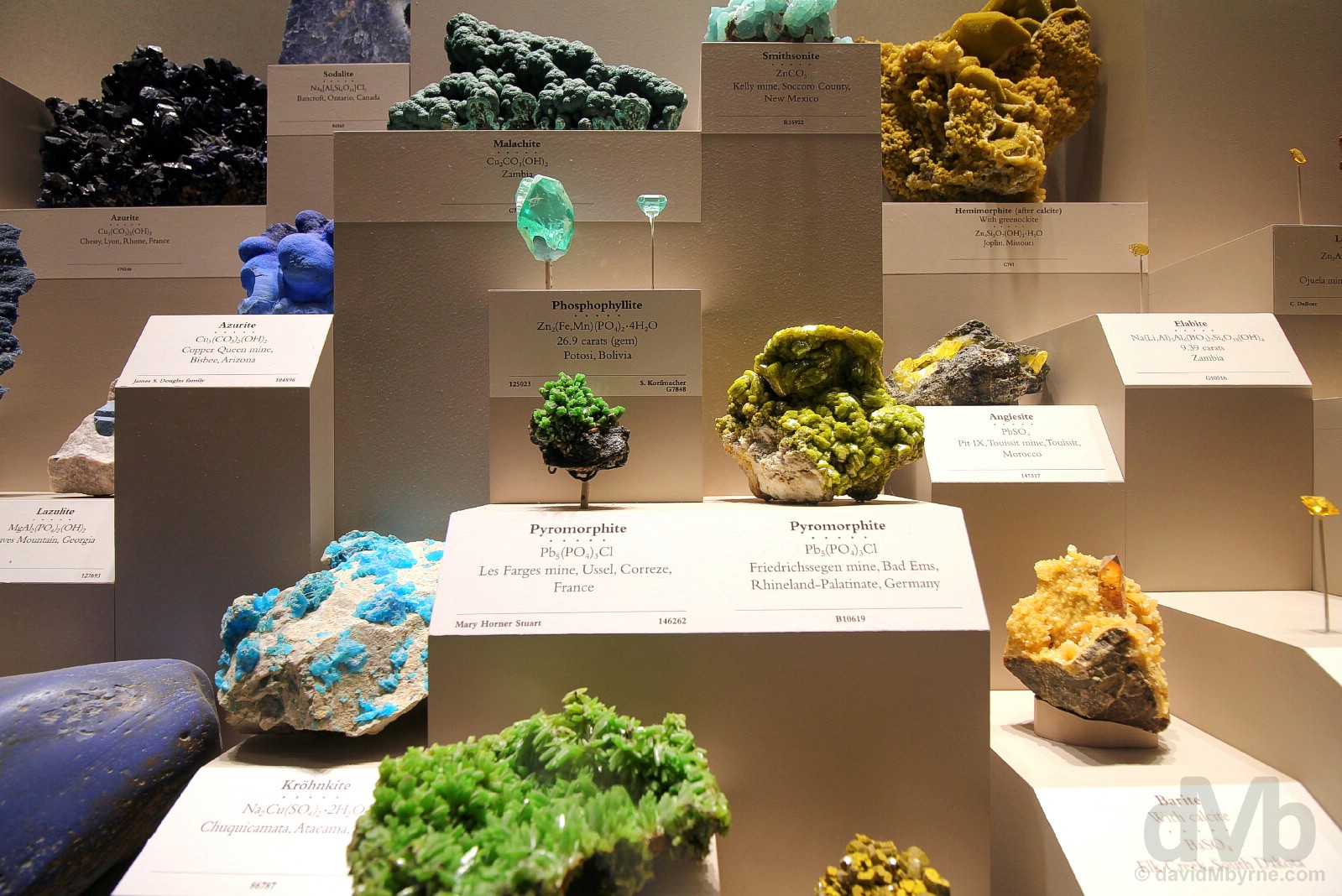
In the Minerals & Gems Gallery of the National Museum of Natural History, Washington D.C. October 1, 2018.
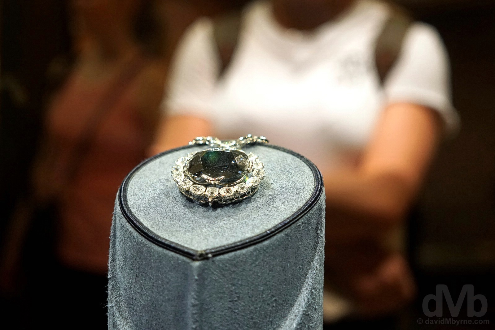
HOPE DIAMOND || The Hope Diamond on display in the National Museum of Natural History, Washington D.C. October 1, 2018.
While it may not be the world’s most valuable diamond (I hear that’s the priceless 105-carat Koh-I-Noor, part of the British Crown Jewels and on display in the Tower of London’s Jewel House), this – the famous Hope Diamond – still has a great shout as the world’s most famous bit of bling. The cornerstone of the National Gem Collection and probably the National Museum of Natural History’s preeminent piece, the text accompanying it informs all that they are ‘… looking at one of the world’s most famous gems – renowned for its flawless clarity, rare deep color, and eventful history‘. Once owned by Louis XIV of France and supposedly cursed, it was gifted to the museum by New York gem merchant Harry Winston, a.k.a. the King of Diamonds, in 1958 (one of the most prominent jewelers of his time, Winston had purchased it 9 years earlier in 1949) & has been on rotating display behind glass here ever since (the continual rotating, the glass and the crowds means it’s a hard dazzler to photograph). The rare-blue diamond was believed found in India’s Kollur Mine in the early 1600s. It has been recut & reduced in size twice since to its present weight of 45.52 carats, but has steadily increased in value – it’s valued today at approximately $350 million (& is reportedly insured for the tidy sum of $250 million).
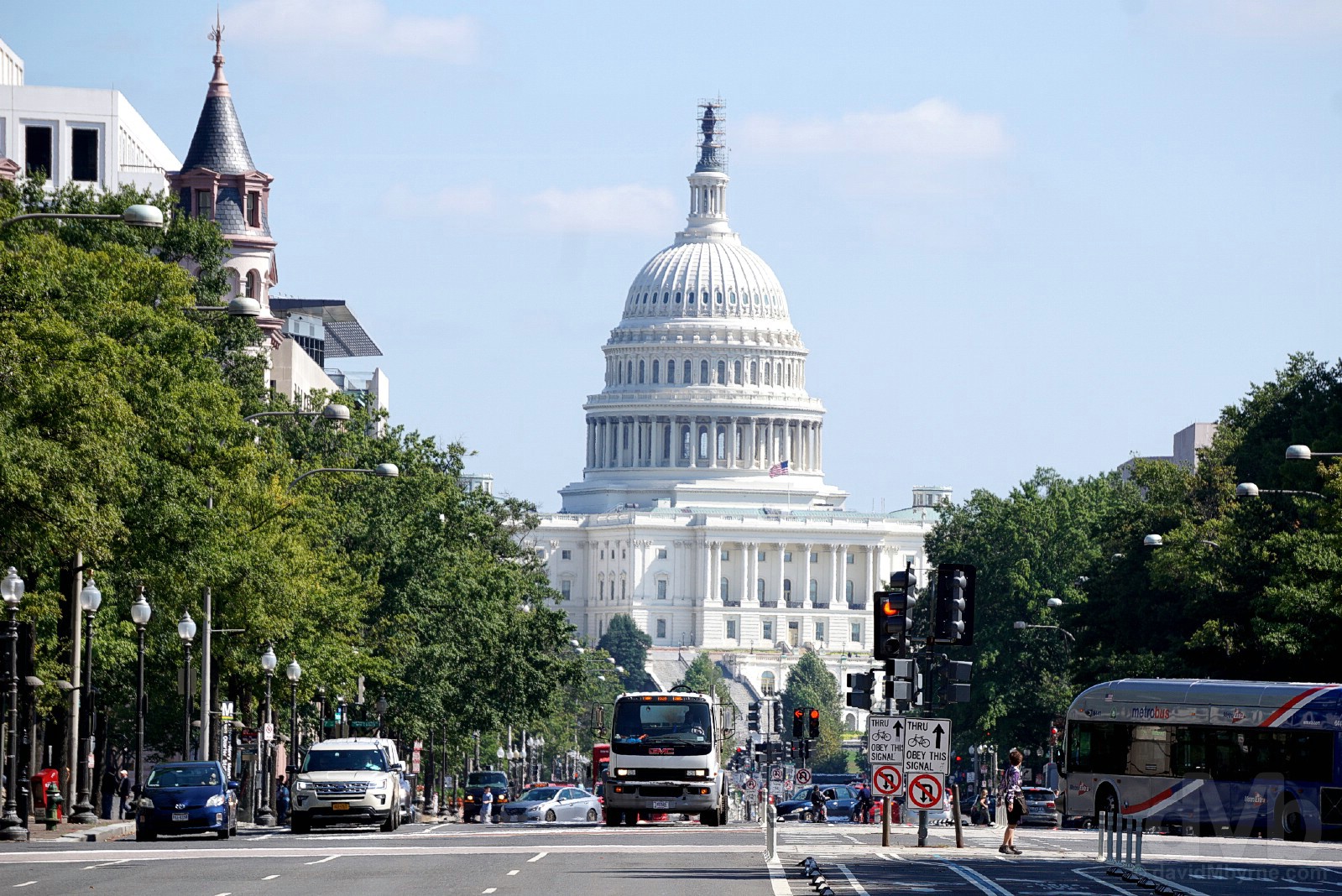
The United States Capitol building again, this time as seen from Pennsylvania Avenue, Washington D.C. October 1, 2018.
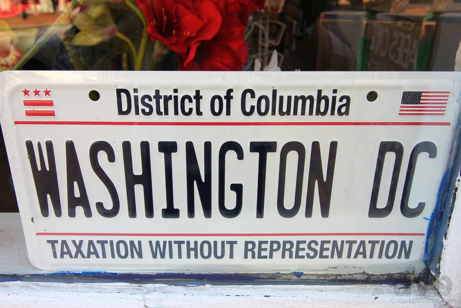
Taxation Without Representation. Where have we heard that before? Wasn’t the city’s very founding in 1791 the result of a need to have a capital city/district for the new country, the country itself borne out of a conflict – the 1775 to 1783 American Revolution – the catalyst for which being colonist no-taxation-without-representation disgruntlement with the then ruling British & its distant parliament? Yes, yes it was. Interesting that. Washington D.C. October 1, 2018.
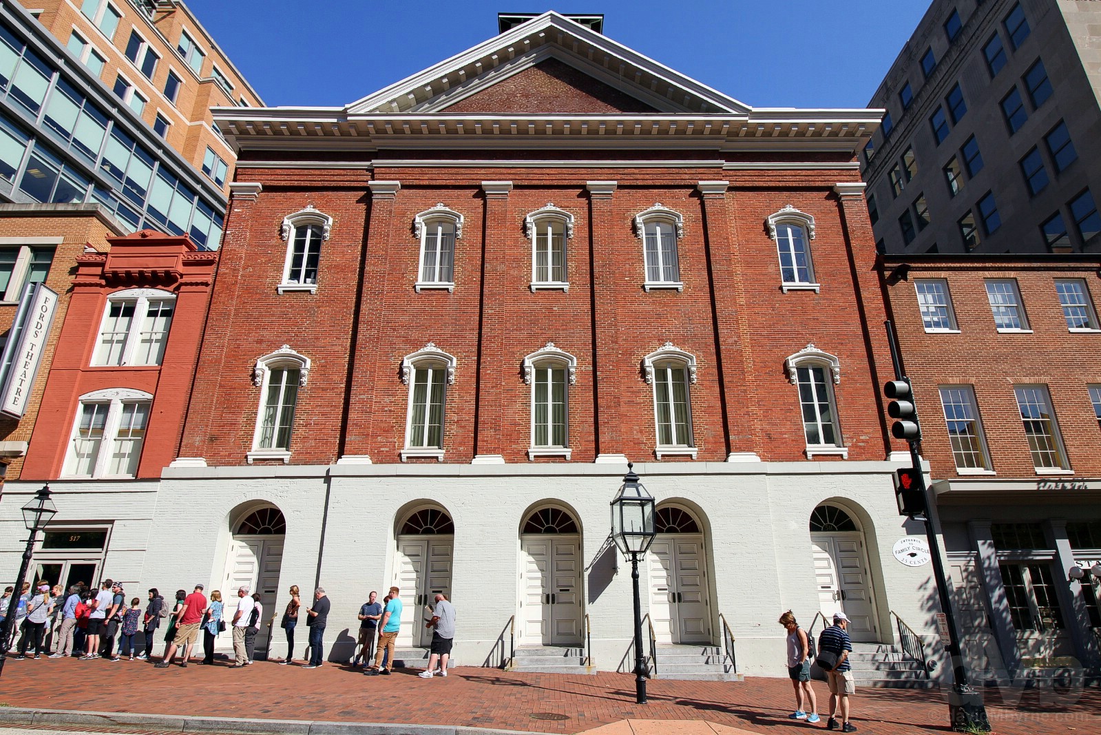
FORD’S THEATRE || The facade of Ford’s Theatre, 511 10th St NW, Washington D.C. October 1, 2018.
The crowds outside told us this was somewhere of interest, it being Ford’s Theatre, the site of the assassination of US President Abraham Lincoln on April 14 1865 by John Wilkes Booth. Opened in August of 1863, restored at least twice since and today a National Historic Site – the Ford’s Theatre National Historic Site – the theatre is still an active regional performance venue with a capacity of over 650.
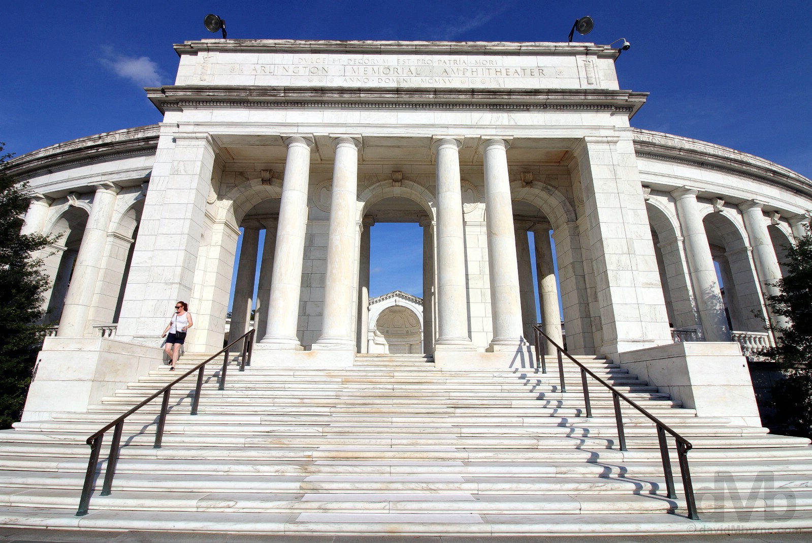
We, and just like we did on Day 5 last year, crossed the Potomac River and paid a visit to Arlington National Cemetery in neighbouring Virginia before leaving the D.C. region. And even though we visited the cemetery’s JFK Gravesite and Arlington House, The Robert E. Lee Memorial on last year’s visit, we still had some unfinished business with America’s most sacred shrine.

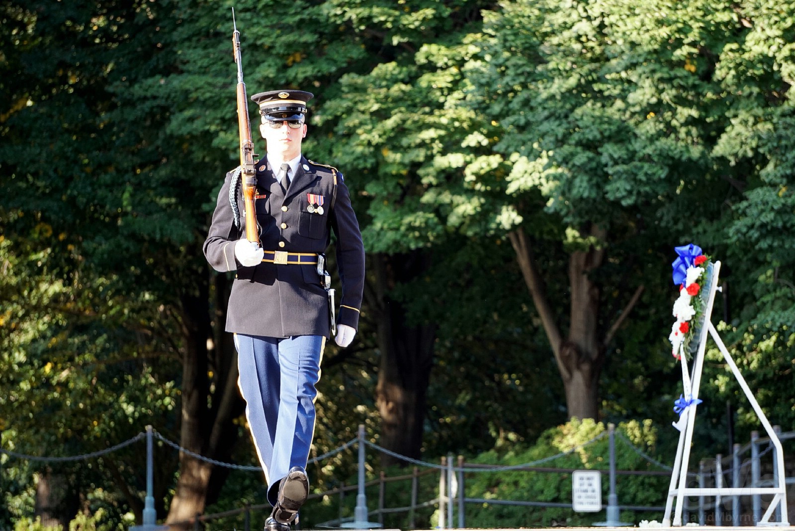
TOMB OF THE UNKNOWN SOLDIER || At the Tomb of The Unknown Soldier in Arlington National Cemetery, Virginia. October 1, 2018.
Arlington’s memorial to US service personnel who have fallen and whose remains have not been identified is as sombre as you might expect. The monument, dedicated in 1921 in the plaza of the new Arlington National Cemetery Memorial Amphitheater (it completed a year earlier in 1920) and which has no officially designated name, serves as the final resting place for four Unknows, one from each of the World Wars (the WW I Unknown was interned in 1921, the WW II Unknown in 1958), one from the Korean War (also interned in 1958) & one from the Vietnam War (interned in 1984). The memorial’s white marble sarcophagus, seen here, is inscribed with the words ‘HERE RESTS IN HONORED GLORY AN AMERICAN SOLDIER KNOWN BUT TO GOD’ and is ceremoniously guarded by Honor Guards, active soldiers of the US Army who do not wear rank insignia so as not to outrank the Unknowns. Their meticulous, repetitive & somewhat theatrical routine is both a fascinating and hypnotic spectacle of sharp about-turns, heel clicks, shoulder-arm movements & 21-step marches (signifying the 21-gun salute, the highest military honour that can be bestowed) along the 63-foot-long (19.2 metre) black rubber mat laid across the Tomb. We had the good fortune to witness the last changing of the guard ceremony for the day, a massively symbolic ceremony conducted in accordance with Army regulations.
– As reproduced from a display in the Visitors Center of Arlington National Cemetery

United States Marine Corps War Memorial
Unfinished business here, too. I vividly remember walking the 2-mile distance from the National Mall to the United States Marine Corps War Memorial in 1998. Closed this time last year as part of a extensive $5 million refurbishment, the first since its erection in 1956, I was happy to find it open today (and to be able to drive to it), our final stop before leaving the D.C. region for the cooler Appalachian hills of western Virginia.
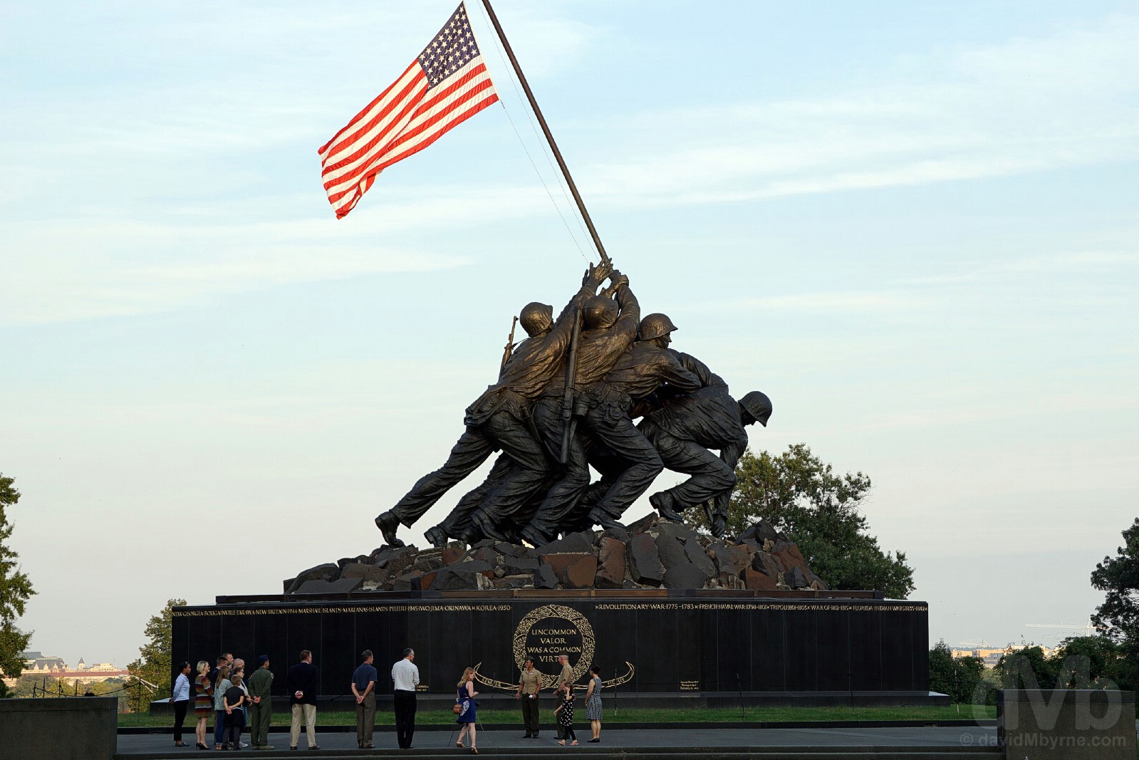
IWO JIMA MEMORIAL || The United States Marine Corps War Memorial, Arlington, Virginia. October 1, 2018.
Officially the United States Marine Corps War Memorial but otherwise known as the Iwo Jima Memorial, this iconic bronze sculpture of 32-feet-high (9.75 metre) figures atop a Swedish granite pedestal by Felix de Weldon depicts the famous Pulitzer Prize–winning photograph Raising the Flag on Iwo Jima by AP photographer Joe Rosenthal, who captured six Marines raising a US flag atop Mount Suribachi on February 23, 1945 during the World War II Battle of Iwo Jima, a small (8 square miles, 21 km²) Japanese volcanic island some 750 miles (1,200 km) off the Japanese mainland (three of the 6 Marines captured in the photograph would be killed in action over the proceeding days). Dedicated to all US Marine Corps personnel who died in the defense of the US since the US Marine Corps’ inception in November 1775, the memorial’s importance is highlighted by the fact that it is one of the few official sites where a proclamation states a US flag must fly over the memorial 24 hours a day.
Image || At the Shenandoah Valley Overlook of the Skyline Drive of Shenandoah National Park, Virginia.
“Our plan to drive the scenic Skyline Drive of Virginia’s Shenandoah National Park on Day 29 of our 2016 US road trip was thwarted, foggy conditions meaning we didn’t have to venture too far beyond the park’s southern Rockfish Gap entrance station before fully grasping the hopelessness of the situation. Two-plus years on and it would seem now that that 2016 meteorological intervention was well intended, saving the park and its All-American drive to enable them to enjoyed as the family outing they were to be today.”
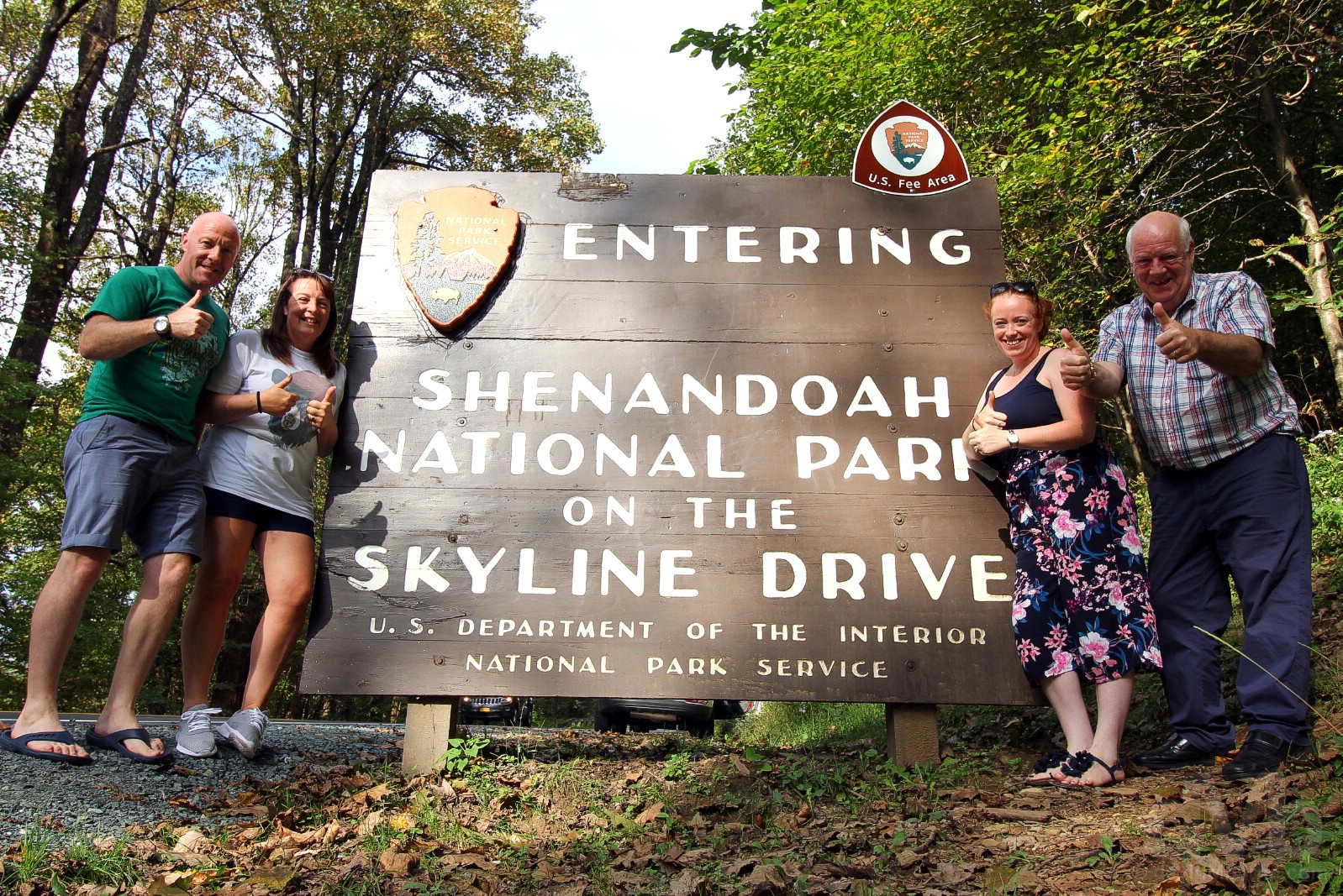
Day 4 || October 2 2018
Route || Front Royal to Williamsburg, Virginia
Miles (Kilometres) Driven || 263 (423)
Today’s Highlight || The Skyline Drive of Shenandoah National Park
Our plan to drive the scenic Skyline Drive of Virginia’s Shenandoah National Park on Day 29 of our 2016 US road trip was thwarted, foggy conditions meaning we didn’t have to venture too far beyond the park’s southern Rockfish Gap entrance station before fully grasping the hopelessness of the situation. Two-plus years on and it would seem now that that 2016 meteorological intervention was well intended, saving the park and its famous drive to enable them to enjoyed as the family outing they were to be today.

For Sale in Shenandoah National Park during a stop on the Skyline Drive. October 2, 2018.
– Lonely Planet USA, 6th Edition, commenting on the Shenandoah Valley & Shenandoah National Park
Shenandoah National Park
Size: 199,173 acres/806 km². Founded: 1935. Annual Visitors: 1.3 million.  A classic road trip lies within the boundaries of this park. Skyline Drive runs like a 105-mile spine along the crest of the Blue Ridge Mountains. With 75 scenic overlooks and a leisurely speed limit, traveling end to end takes three to four hours. The roadsides bloom with a seasonal progression of wildflowers — from early trillium through azaleas and mountain laurel to black-eyed Susans and goldenrods. The Wilderness Society listed Shenandoah among its best parks for fall color. The annual Fall Foliage Bike Festival coincides with that display. Although the park can be driven in a day, accommodations and dining are available for those who linger to explore the paths, including 101 miles of the Appalachian Trail. Overnight options include the 1939 Big Meadows Lodge, a stone and wormy-chestnut structure listed on the National Register of Historic Places. Before the area was designated as a park, homeowners here kept farms, orchards and grazing animals. Traces of former residents include garden-patch daffodils and more than 100 family cemeteries, some still maintained by descendants. One site of note is Rapidan Camp, the summer retreat of President Herbert Hoover. Here, 70 miles from the White House on 164 wooded acres, the president, first lady and friends relaxed and held meetings. The guest book of the 13-cabin compound includes such names as Lindbergh, Ford and Edison. In 1935, the compound became part of the park; its three remaining buildings are open for ranger-led tours. Today, summer visitors may catch a view of a more ethereal variety. “Fog lies like a soft white blanket on the Shenandoah Valley and the Piedmont, while the mountaintop is clear,” visitskylinedrive.org says. “If conditions are right, you can look down on a ‘fog ocean,’ with the lower peaks rising above it like islands.”
From The Washington Post – The Essential guide to all 59 U.S. national parks.
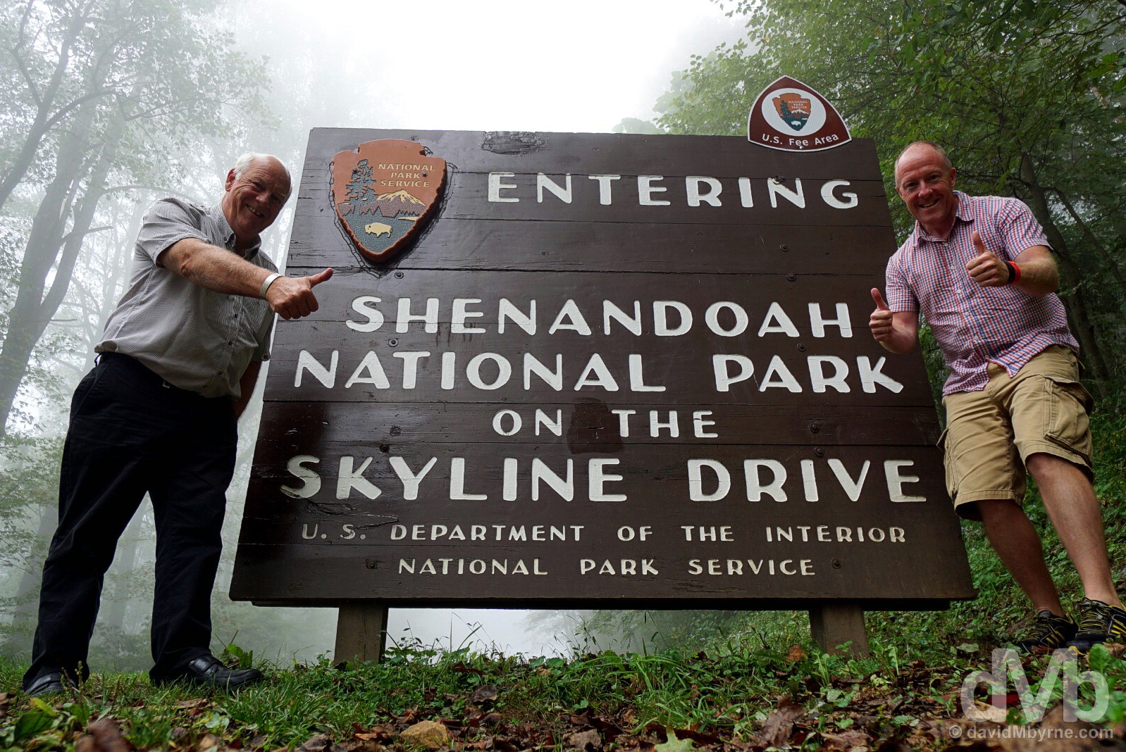
2016. Even though we didn’t actually visit the park or drive the Skyline Drive in 2016, we did of course get the obligatory picture at the park’s southern (& foggy on this particular day) Rockfish Gap entrance station. September 25, 2016.
2018. A family affair. At the same southern, Rockfish Gap entrance station when leaving the park and having just complete the Skyline Drive. October 2, 2018.
– President Franklin Roosevelt during Shenandoah’s Dedication in 1935
Shenandoah National Park & Skyline Drive
Formed from a patchwork of over 1,000 privately owned tracts of forest, fields, orchards and home sites, Shenandoah National Park was officially dedicated in 1935 to bring the western national park experience to the urban east. Expanded in 1976 under the 1964 Wilderness Act by 80,000 acres of land formally used for farming or industry, today the park is a 200,000-acre wilderness area of ‘recreation & re-creation’ only 75 miles west of Washington D.C. & within a few hours’ drive of millions. Aside from its famous National Scenic Byway-listed drive, the park boasts over 500 miles of trails, over 100 miles of which form part of the famed Appalachian Trail, a 2,000-mile trail stretching from Maine to Georgia.
– Southern Appalachian National Park Committee Report, 1931
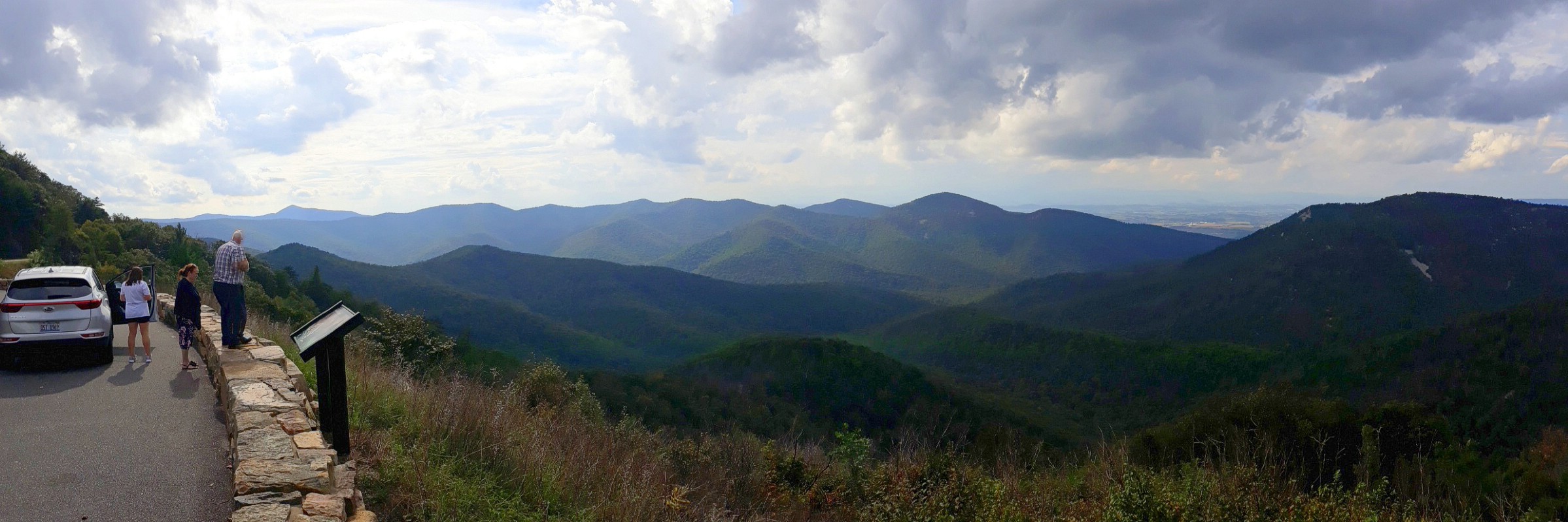
SKYLINE DRIVE || At an overlook on the National Scenic Byway-listed Skyline Drive in Shenandoah National Park, Virginia. October 2, 2018.
Although Shenandoah National Park wasn’t officially designated until 1935, by the late 1920s motor car ownership in the US was such that early park advocates proposed that its main attraction – ‘a possible sky-line drive’ – be built for the motoring tourist, the lure being leisurely drives and picnics in the cool mountain air. ![]() Although the 1930’s Great Depression stalled funding for land acquisition, this didn’t prevent the first sections of the road opening temporarily in 1932. Beset with problems, chief among them erosion, the Civilian Conservation Corps arrived in 1933 to start work on the infrastructure enjoyed by millions today, mainly the 75 scenic overlooks & 2 the visitor centres encountered en route. The leisurely 105-mile drive, designed with beauty & pleasure in mind, meanders along a narrow mountain road between undulating ridges of the Blue Ridge Mountains guaranteeing numerous epic vistas of Piedmont Valley to the east & Shenandoah River Valley to the west, seen here (although still largely rural, both valleys are less rural than they were decades ago, structures built outside of the park’s boundary since its 1930’s dedication clearly visible from the overlooks and somewhat detracting from the park’s ‘wilderness’ tag).
Although the 1930’s Great Depression stalled funding for land acquisition, this didn’t prevent the first sections of the road opening temporarily in 1932. Beset with problems, chief among them erosion, the Civilian Conservation Corps arrived in 1933 to start work on the infrastructure enjoyed by millions today, mainly the 75 scenic overlooks & 2 the visitor centres encountered en route. The leisurely 105-mile drive, designed with beauty & pleasure in mind, meanders along a narrow mountain road between undulating ridges of the Blue Ridge Mountains guaranteeing numerous epic vistas of Piedmont Valley to the east & Shenandoah River Valley to the west, seen here (although still largely rural, both valleys are less rural than they were decades ago, structures built outside of the park’s boundary since its 1930’s dedication clearly visible from the overlooks and somewhat detracting from the park’s ‘wilderness’ tag).
– Reproduced from an early National Park Service brochure
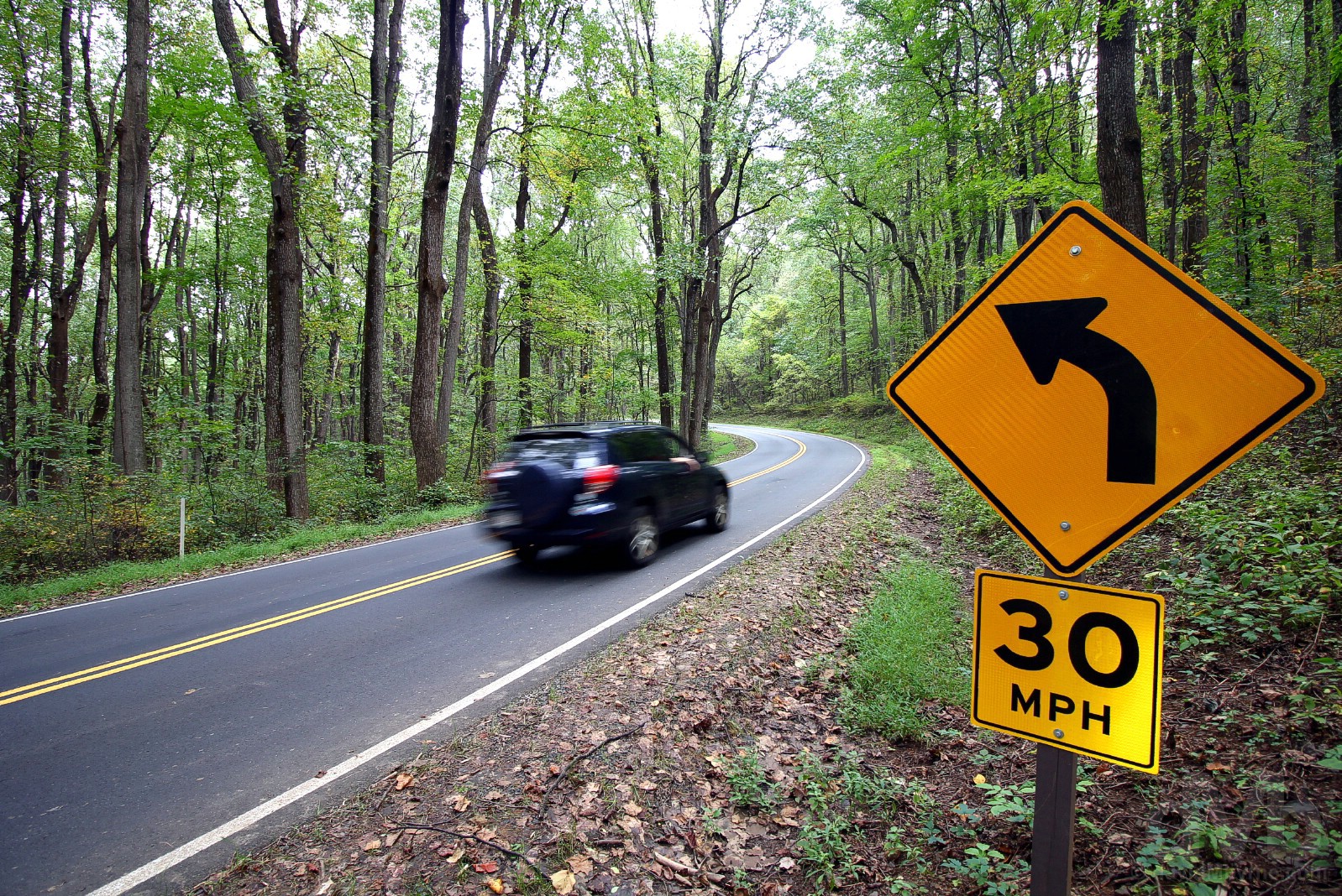
On a (still vibrantly green) 30 mph portion of the Skyline Drive in Shenandoah National Park, Virginia. October 2, 2018.
Suffice it to say, Skyline Drive is billed as one of the nation’s premier drives, especially in autumn. The drive should take about 3 to 4 hours, although the scenic overlooks, visitor centres and a reduced speed limit on some stretches of the road do their upmost to delay progress. Most of the drive is subjected to a 35-mph speed limit. This is obviously due to the narrow & twisty nature of the drive but also to ensure sufficient time to stop should any of the wild animals that frequent the park decide to dart across the road. We were on the lookout, but we didn’t see any Black Bears, that despite the Entrance Station Ranger’s assertion that the probability of sighting one of the small & plentiful resident bears was ‘high.’ And nor did we see any fantastical fall foliage, a vibrantly green summer-esque hue still lingering into early October along most of the route – it would seem we were just a few weeks too early to sample the best of an autumnal display, the official park brochure confirming that ‘crisp fall days bring brilliant leaf colors, usually peaking between October 10 and 25.’ Oh well.
Image || Restored buildings along E Duke of Gloucester Street in Colonial Williamsburg, Virginia.
“There were a few members of staff already in place resplendent in period garb, early into their latest shift to sell a reenactment of 18th-century British America, each one a character on the set of the astonishing 300-acre open-air assemblage of restored or re-created period buildings that is the world’s largest living-history museum…”
Day 5 || October 3 2018
Route || Williamsburg, Virginia to Nags Head, Outer Banks, North Carolina
Miles (Kilometres) Driven || 165 (266)
Today’s Highlight || Outer Banks, The Return
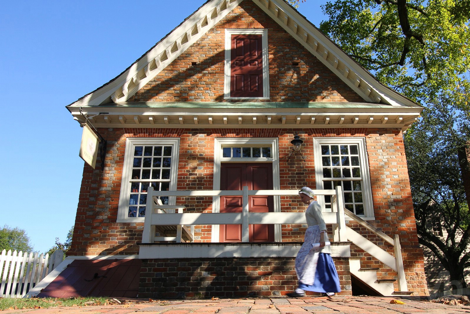
It was early on this morning when we found ourselves back on the restored bygone-era streets of Colonial Williamsburg. Too early, it would seem. There were a few members of staff already in place resplendent in period garb, early into their latest shift to sell a reenactment of 18th-century British America, each one a character on the set of the astonishing 300-acre open-air assemblage of restored or re-created period buildings that is the world’s largest living-history museum, the result of one of the largest restoration projects in US history (a project that began in 1927). But there was a noticeable paucity of livestock – no oxen pulling carts, no chickens ambling free, no horses waiting to pull carriages for the amusement of the tourists who, save for us, had yet to arrive.
Duke of Gloucester Street, Colonial Williamsburg, Virginia. October 3, 2018.
– The Colonial Williamsburg Foundation, the non-profit entity that manages Colonial Williamsburg
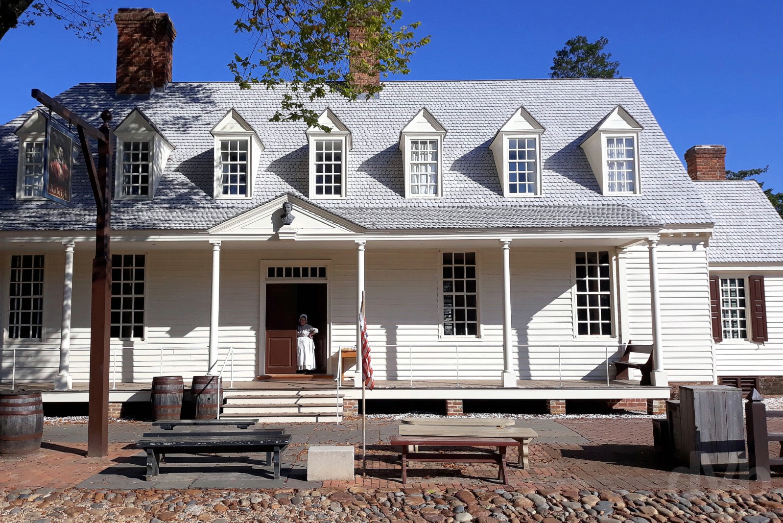
So, and in a repeat of last year (when I blogged extensively on the Colonial Williamsburg experience), we took a few pictures while walking from Merchants Square east up Duke of Gloucester Street to the Capitol Building and back again, passing the slew of faithfully reproduced houses, taverns, shops, inns, workshops & outbuildings of Williamsburg, the old colonial capital where the flames of the American Revolution were fanned. We then hit the road for the Outer Banks of North Carolina. It – Colonial Williamsburg – was all very familiar, and all very familiarly photogenic, not that familiarity does anything to detract from the uniqueness of this amazing place.
COURTHOUSE || Outside the Courthouse in Colonial Williamsburg, Virginia. October 3, 2018.
One of the most impressive of the hundreds of restored edifices that comprise Colonial Williamsburg, the settlement’s original redbrick Georgian-style Courthouse was built between 1770 and 1772, acquired by Colonial Williamsburg in 1928, and restored in 1932. Built to serve both Williamsburg and James City County, this was where Benjamin Waller read aloud the Declaration of Independence on July 25, 1776, after it arrived from history heavy Philadelphia. Today it’s one of the more popular paid attractions of Colonial Williamsburg – while it’s free to wander the Colonial Williamsburg site, a trait unique among similar living-history museums worldwide, most buildings charge an entrance fee to allow visitors fully immerse themselves in 18th-century British America.
– ColonialWilliamsburg.com commenting on their Colonial Williamsburg Courthouse
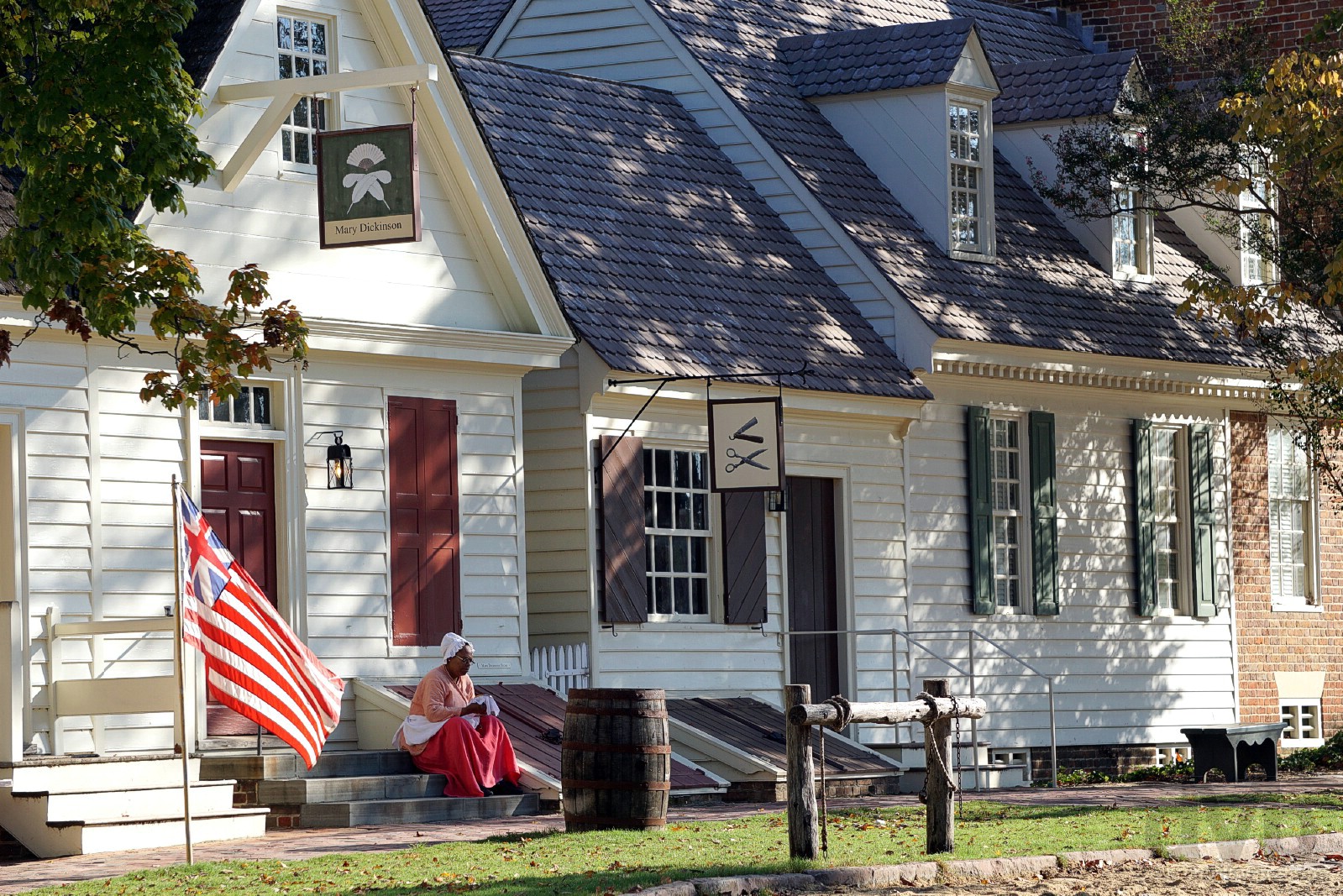
Mary Dickinson Store, the place in town to stock up on an array of 18th-century ladies jewlery, toiletries & fashion (petticoats, short gowns, cloaks, mitts, caps etc.). Duke of Gloucester Street, Colonial Williamsburg, Virginia. October 3, 2018.
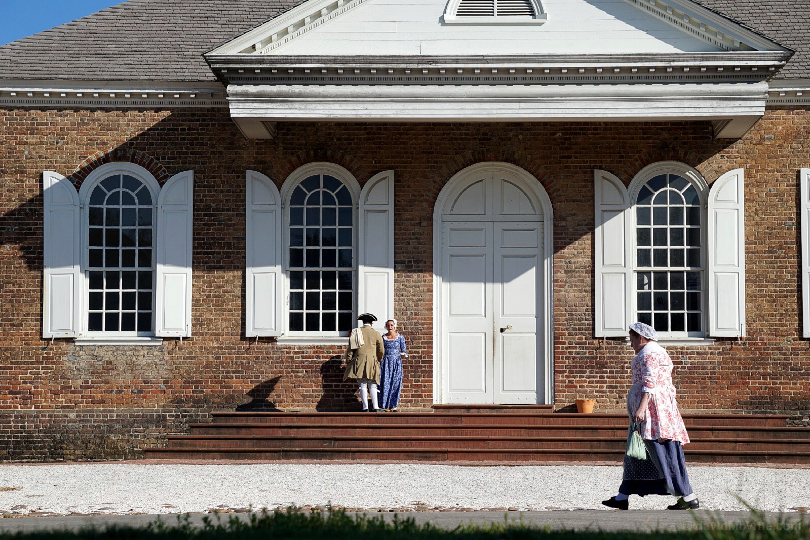
RALEIGH TAVERN || The Raleigh Tavern, Colonial Williamsburg, Virginia. October 3, 2018.
The unassuming Raleigh Tavern bags the Colonial Williamsburg bragging rights as the site’s very first attraction – restored on its original foundations, its opening to the public in September 1932 marked the official opening of the Colonial Williamsburg site. Believed first built in the early 1730s, it was said to be one of the largest taverns in colonial Virginia and gained quite a reputation as a gathering point for pre-American Revolutionary movements. Unlike other ‘taverns’ in Colonial Williamsburg today which operate as restaurants or inns, the reconstructed Raleigh Tavern – named after Sir Walter Raleigh, an important figure in the English settlement of Virginia and whose portrait hangs outside & whose bust sits above the entrance door – serves as a museum showcasing to visitors what the tavern would have appeared like way back when.
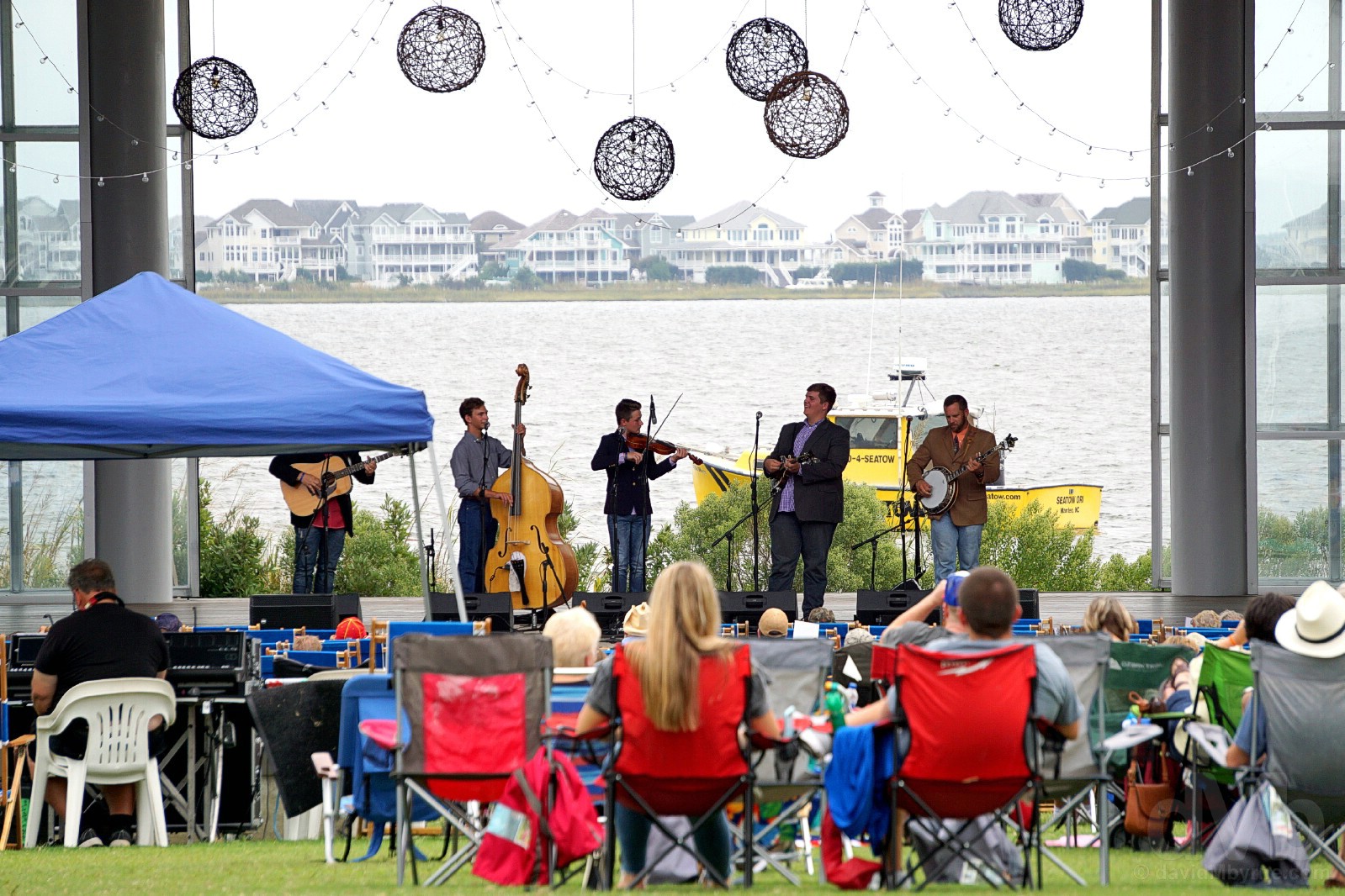
Image || Sunrise, Nags Head, Bodie Island, Outer Banks, North Carolina.
“Sun (& sunrises), sea, sand &, emm, bluegrass. No, of course it’s not your typical Outer Banks combo, but it’s the bluegrass that makes the Outer Banks special for us. It’s mountain music by the sea.”
Days 6-8 || October 4-6 2018
Route || Nags Head, Outer Banks, North Carolina
Miles (Kilometres) Driven || 165 (266)
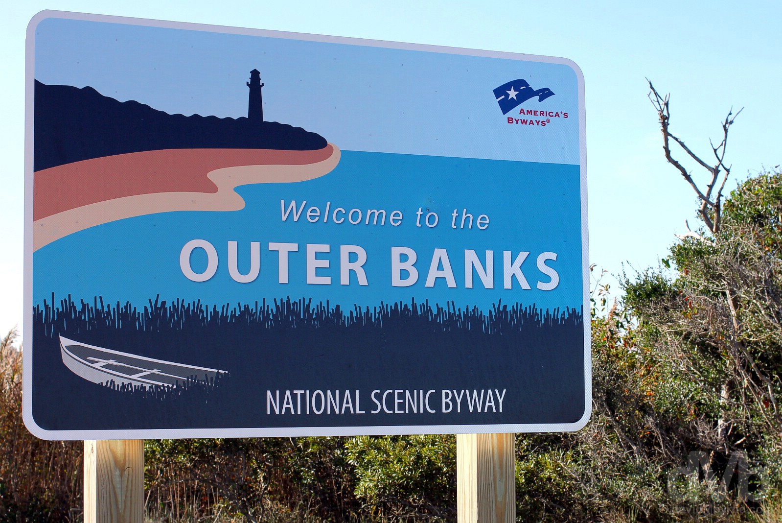
It felt good to stay put for a few days. It was even better to do so back on the Outer Banks of North Carolina, a.k.a OBX, an exposed string of narrow low-lying sandbar islands (from north to south, Bodie Island, Roanoke Island, Hatteras Island & Ocracoke Island) running for 200 miles (320 kilometres) and sheltering the US mainland in the west from the vast & blustery expanse of the Atlantic Ocean in the east.

On the streets of Manteo, Roanoke Island, Outer Banks, North Carolina’s number 1 family-friendly beach rental haven. October 4, 2018.
–OuterBanks.org
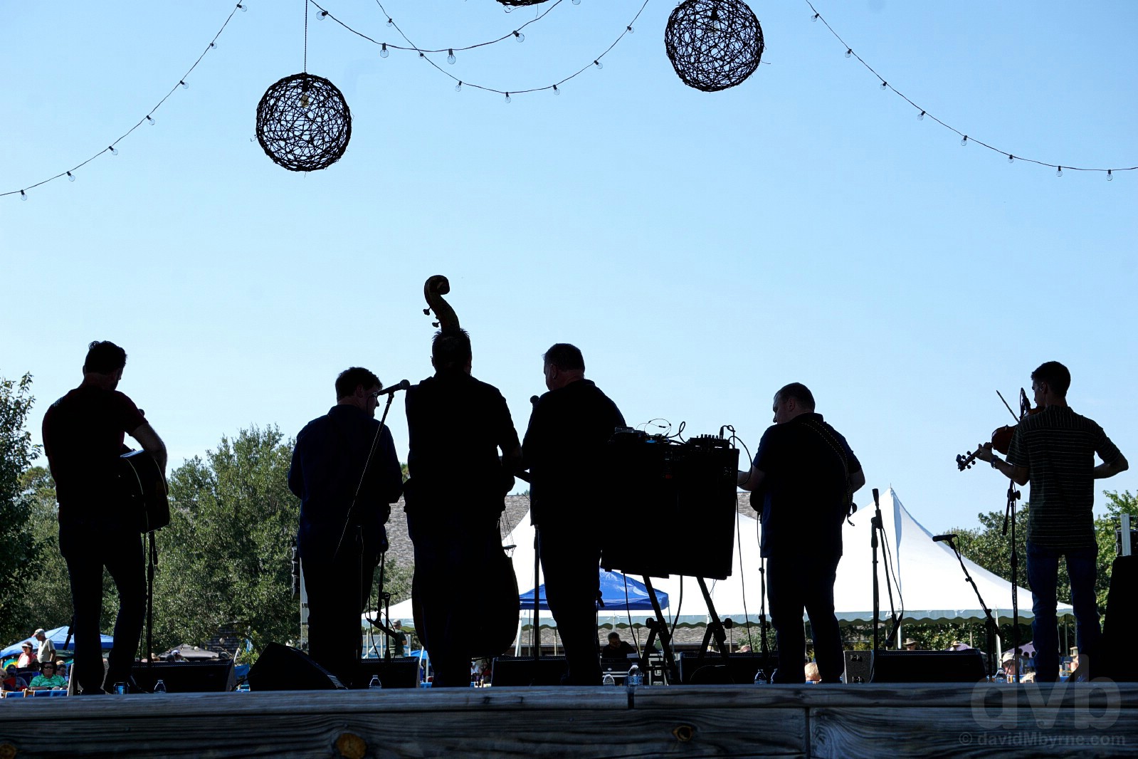
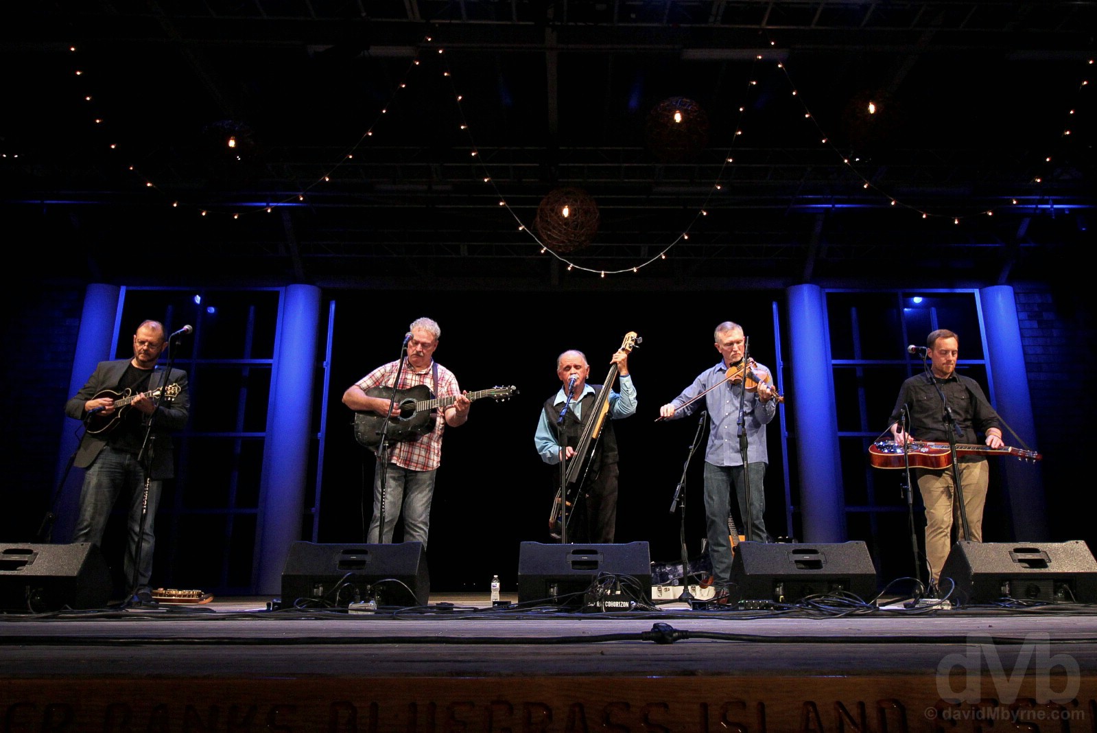
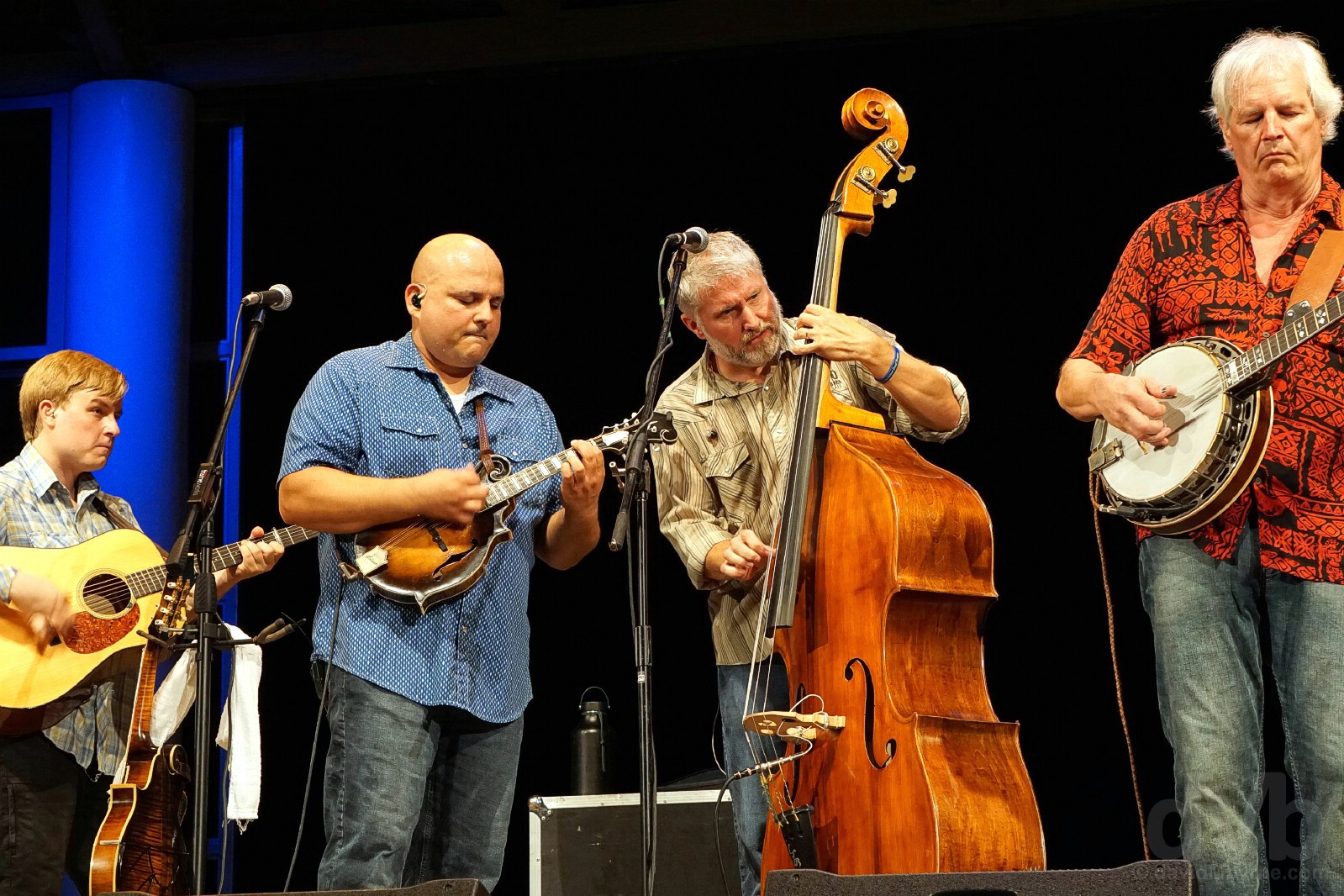
Bluegrass Island, The Return
Sun (& sunrises), sea, sand &, emm, bluegrass. No, of course it’s not your typical Outer Banks combo, but it’s the bluegrass that makes the Outer Banks special for us. It’s mountain music by the sea.
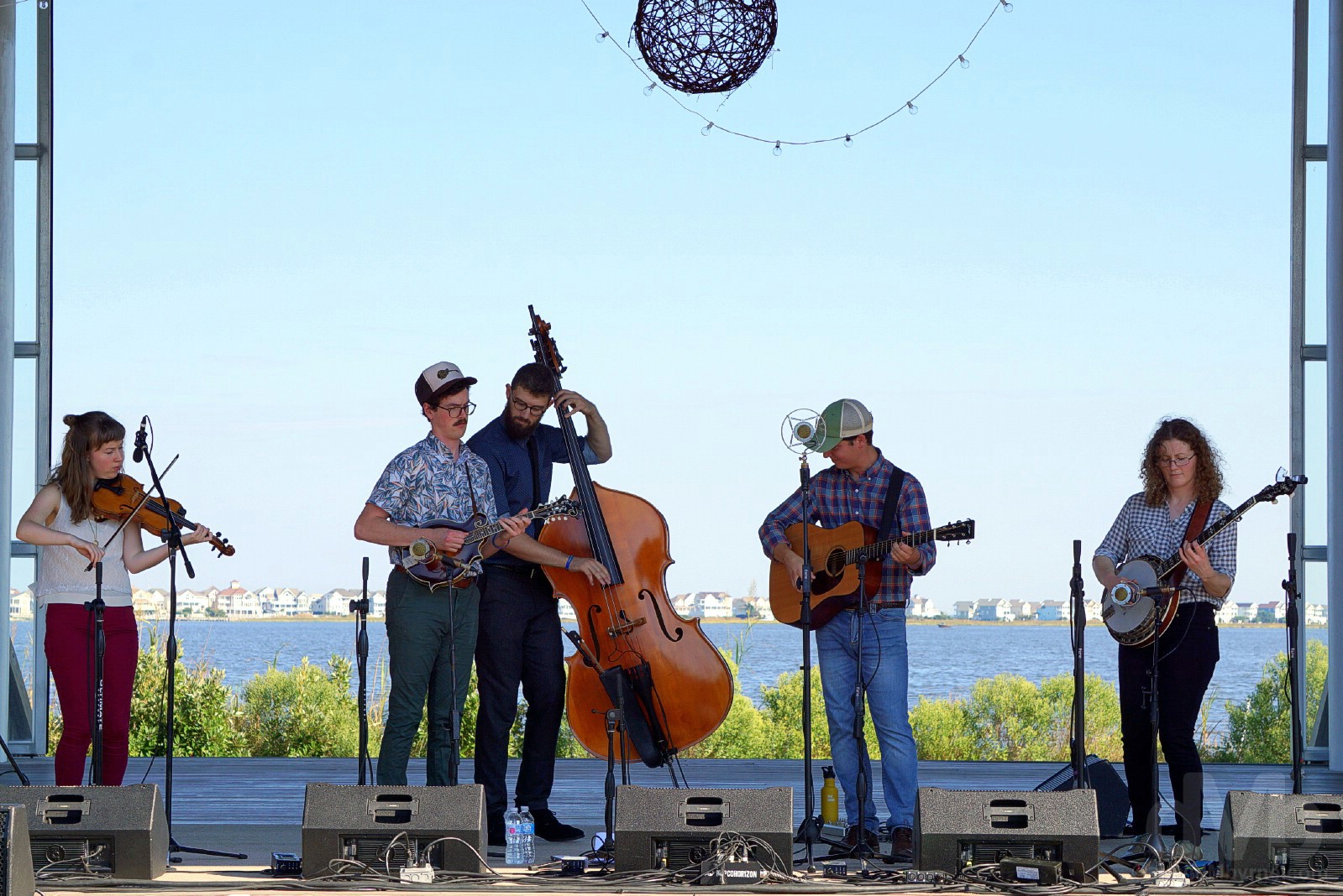
Blue skies. Blue water. Bluegrass. Mile Twelve performing on Day 2 of the 3-day 2018 Outer Banks Bluegrass Island Festival at Roanoke Island Festival Park (a.k.a Bluegrass Island), Roanoke Island, Manteo, Outer Banks, North Carolina. October 5, 2018.

Enjoying the music at the 2018 Outer Banks Bluegrass Island Festival at Roanoke Island Festival Park, Roanoke Island, Manteo, Outer Banks, North Carolina. October 6, 2018.
Last year’s memorable Bluegrass Island buzz was the catalyst for this year’s visit. It was just as enjoyable second time around, familiarity doing nothing to diminish the experience.
A few more captures from Bluegrass Island, The 2018 Edition.
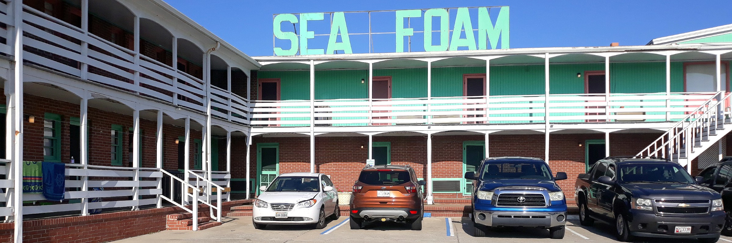
SEA FOAM || The Sea Foam Motel, Nags Head, Bodie Island, Outer Banks, North Carolina. October 6, 2018.
When the Sea Foam Motel invites all to ‘Come Join Us on the Beach’ they ain’t joking. If you’re gonna holiday/vacation by the sea, you may as well stay by the sea. The creaking old dame that is the (mostly) redbrick & wooden Sea Foam, where you’ll doze off to the sounds of crashing Atlantic Ocean waves, is a 2-storey U-shaped Nags Head landmark that was built in 1948, and in parts it looks like it hasn’t received a lick of paint since. Added to the National Register of Historic Places in 2004, it has throwback charm and convenience in abundance, which more than makes up for the lack of modern amenities. If that’s what you crave, there are legions of other uninspiring run-of-the-mill rental & lodging options nearby. This is Nags Head after all.
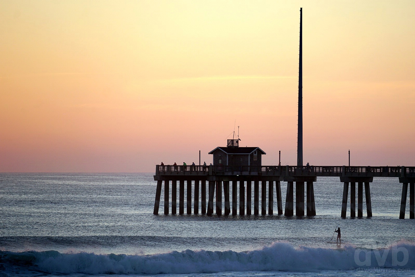
We didn’t even have to leave our Sea Foam room to capture a Nags Head sunrise. Jennette’s Pier waiting for sunrise as seen from the oceanfront balcony of our Sea Foam Motel room. Nags Head, Bodie Island, Outer Banks, North Carolina. October 6, 2018.
JENNETTE’S PIER || Jennette’s Pier as seen from the sands of Nags Head Beach, Nags Head, Bodie Island, Outer Banks, North Carolina. October 6, 2018.
The Sea Foam is in the vicinity of Jennette’s Pier, 2 miles north of the smaller & younger Outer Banks Fishing Pier that I visited last year. At 1,000 feet (305 metres), it is one of the longest & longest running attractions on the Outer Banks – it was first propped up on stilts in 1939 making it the Outer Banks first fishing pier. The devastating Hurricane Isabel of September 2003 wreaked havoc on the Outer Banks and all but destroyed the pier as it then stood, necessitating the construction of the present-day hurricane-resistant structure with solid concrete pilings. It opened in 2009 and is known, as it always has been, as a foremost Outer Banks fishing location while also offering modern facilities for functions (marriages etc.) and a fantastic on-site educational center with seasonal programs for visitors of all ages.
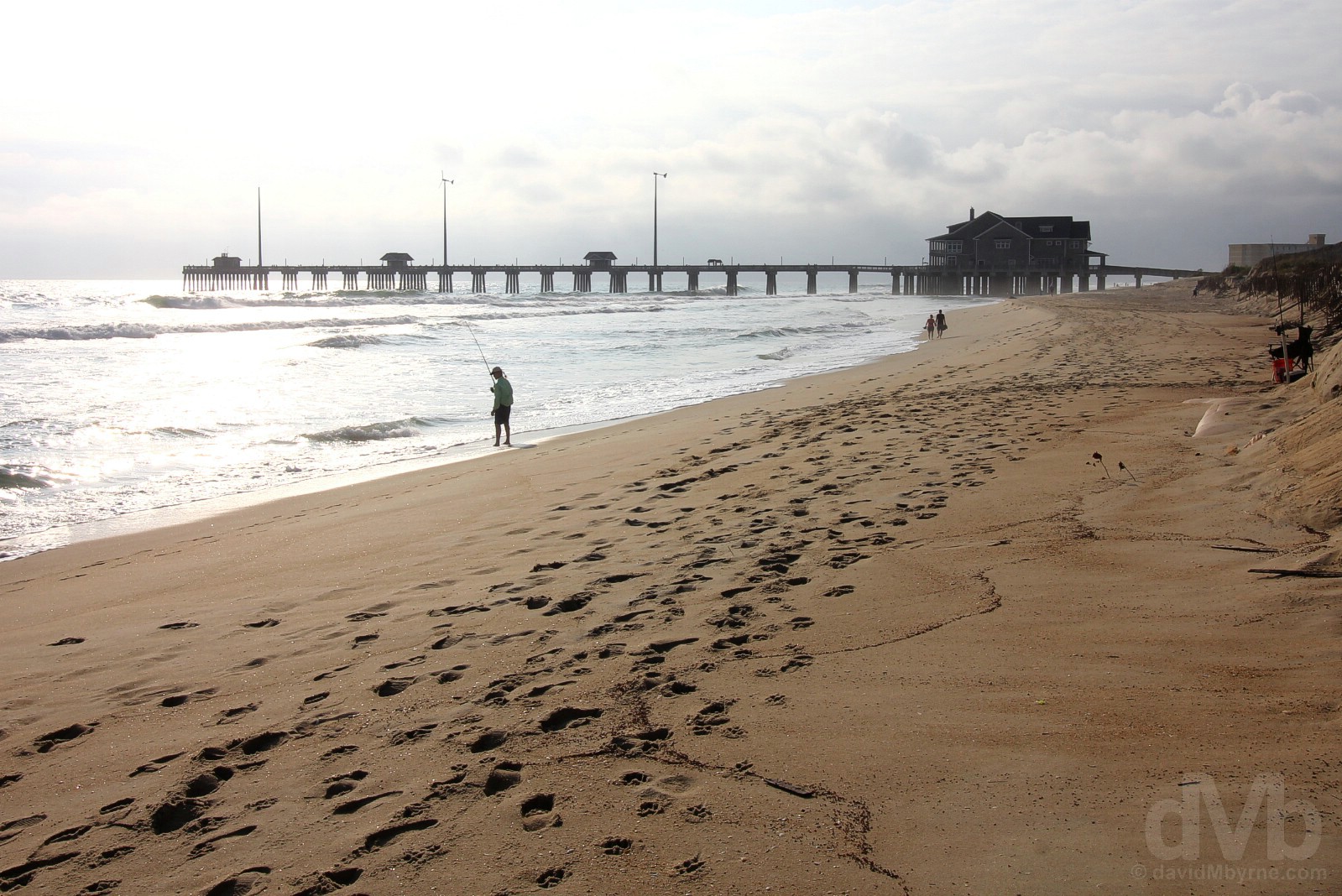
Beyond the obvious (the beach, the seafood & the general swashbuckling maritime vibe), there’s plenty to see & do here on the Outer Banks, not to mention some heavy-hitting pioneering history – the world’s very first successful controlled flight of a powered heavier-than-air vehicle in 1903 is commemorated today at the Wright Brothers National Memorial, while the mystery of the 1580’s Lost Colony, Europe’s very first attempt to established a settlement in the New World and still to this day one of America’s greatest unsolved mysteries, is explored at Roanoke Island’s Fort Raleigh National Historic Site. While finding time between bluegrass sets, we like to feel we did the Outer Banks pretty well last year (including the aforementioned must-sees), but there were still some holdovers from the 2017 OBX to-do list, top of which on the 2018 list was the Cape Hatteras Lighthouse, a 50-mile (80 kilometre) drive south of Nags Head via North Carolina Highway 12, a.k.a. Outer Banks National Scenic Byway.
OUTER BANKS NATIONAL SCENIC BYWAY || The Outer Banks National Scenic Byway, North Carolina Highway 12, Bodie Island, Outer Banks, North Carolina. October 7, 2017.
![]() A 137-mile (221 kilometre) stretch of North Carolina Highway 12, designated as the Outer Banks National Scenic Byway, skirts most of the Cape Hatteras National Seashore, one of North Carolina’s 2 National Seashores, coastal areas federally designated as being of natural and recreational significance as a preserved area. Granting access to a region not accessible by road until the 1920s, this, one of America’s great drives, is a drive billed as leaving the mainland (& roads) behind to sample the simple maritime living of the Outer Banks, where hectic schedules and tourist-driven cities are nowhere to be found. Driving (& boating) between historic Down East communities of rich maritime culture, one encounters an estuarine system of shallow, fertile sounds & wetlands; the aforementioned National Seashore; two national wildlife refuges (Pea & Cedar Islands); beautiful beaches; towering historic brick lighthouses; early US Life-Saving Service & US Coast Guard stations; fishing; wildlife; and, of course, scenic views of barrier islands bracketed by the Atlantic Ocean. This is one National Scenic Byway that deserves time, requires effort and is so far off the beaten path that in places there’s no path at all, beaten or otherwise – portions of the drive (Hatteras Island to Ocracoke Island & Ocracoke Island to Cedar Island) are serviced by ferry and ferry only.
A 137-mile (221 kilometre) stretch of North Carolina Highway 12, designated as the Outer Banks National Scenic Byway, skirts most of the Cape Hatteras National Seashore, one of North Carolina’s 2 National Seashores, coastal areas federally designated as being of natural and recreational significance as a preserved area. Granting access to a region not accessible by road until the 1920s, this, one of America’s great drives, is a drive billed as leaving the mainland (& roads) behind to sample the simple maritime living of the Outer Banks, where hectic schedules and tourist-driven cities are nowhere to be found. Driving (& boating) between historic Down East communities of rich maritime culture, one encounters an estuarine system of shallow, fertile sounds & wetlands; the aforementioned National Seashore; two national wildlife refuges (Pea & Cedar Islands); beautiful beaches; towering historic brick lighthouses; early US Life-Saving Service & US Coast Guard stations; fishing; wildlife; and, of course, scenic views of barrier islands bracketed by the Atlantic Ocean. This is one National Scenic Byway that deserves time, requires effort and is so far off the beaten path that in places there’s no path at all, beaten or otherwise – portions of the drive (Hatteras Island to Ocracoke Island & Ocracoke Island to Cedar Island) are serviced by ferry and ferry only.
– FHWA.dot.gov/byways
While we didn’t need the assistance of boats to get to our destination (that’s a consideration for travel even further south and would be a totally separate adventure in its own right), things really do thin out as you head south, including the already delicate terra firma – sand encroaches on the 2-lane route and there’s water within touching distance on both sides, or far below when crossing the impressive 2.7-mile (4.3 kilometre) span of the 1963 Herbert C Bonner Bridge across Oregon Inlet from Bodie Island to Hatteras Island (construction of a new, $250 million Bonner Bridge is ongoing and scheduled for completion in 2019). Eventually one arrives at the base of the towering Cape Hatteras Lighthouse in the sand-choked Hatteras Island community of Buxton. Located near the southern tip of the island, the lighthouse is only some 13 miles shy of the end of the road and the ferry dock to neighbouring Ocracoke Island.
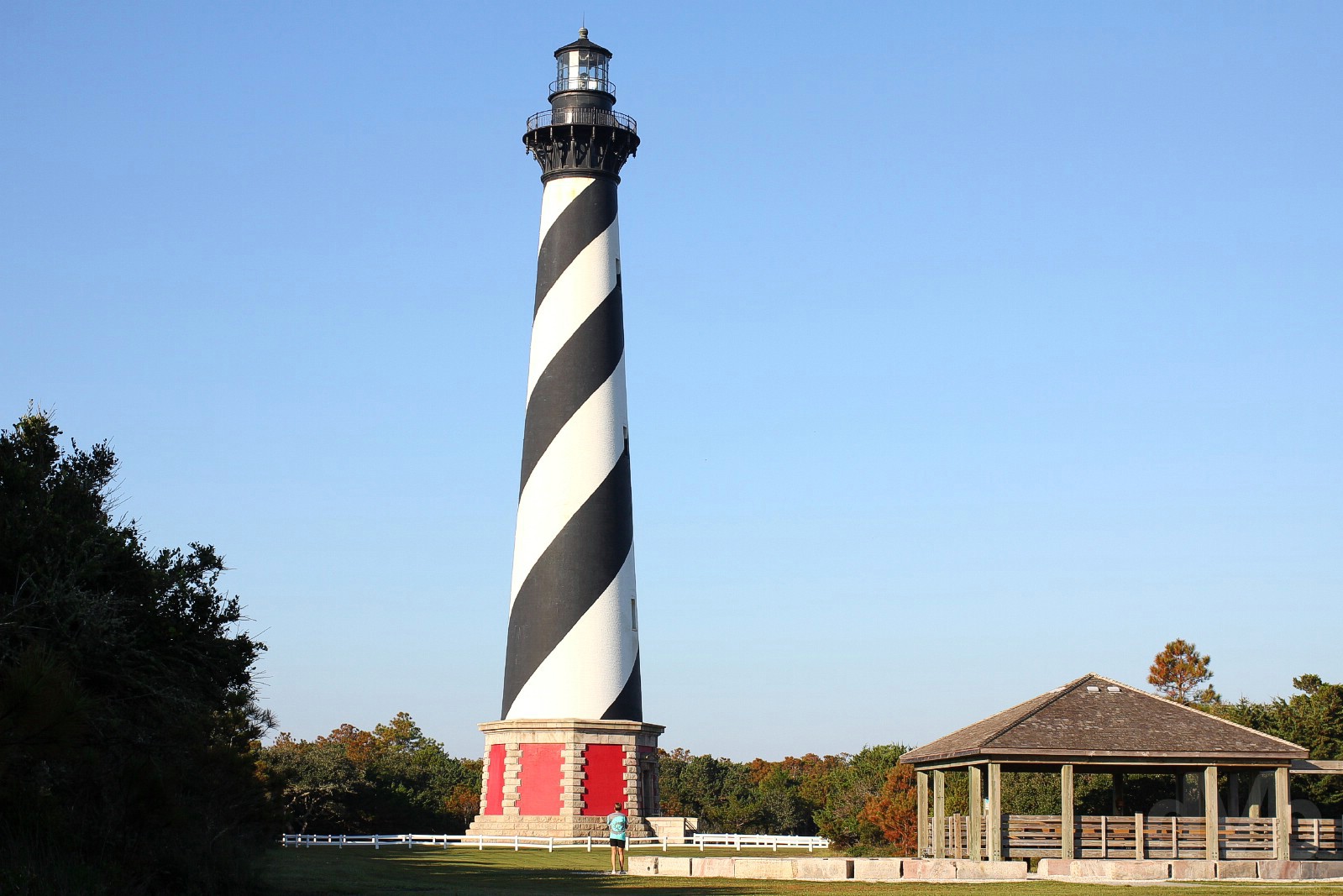
CAPE HATTERAS LIGHTHOUSE || The Cape Hatteras Lighthouse, Buxton, Hatteras Island, Outer Banks, North Carolina. October 4, 2018.
The Bodie Lighthouse is more conveniently located to Nags Head and was visited last year, but it’s not as tall nor as iconic as the Cape Hatteras Lighthouse (none are), visible from afar when approaching towards the end of the scenic 50-mile (80 kilometre) drive south from Nags Head. This is one of the country’s most iconic lighthouses, arguably the centrepiece landmark of the wider Cape Hatteras National Seashore and the towering OBX beacon that’s most likely to get the pulse of a pharologist racing – at 210 feet (64 metres), this is the tallest lighthouse in the US (although only the 15th tallest light in the country, the other 14 towers are all built on higher ground). Originally built in the late 1700s, roughly 1.25 million bricks were used to build the present tower in 1870, moved here from its 1870 location, 0.5 of a mile away, in 1999 in a bid to save it from the encroaching Atlantic shore (this was just 1 year after its 1998 addition to the register of National Historic Landmarks). Its beacon lights up every 7 seconds and projects a beam visible for nearly 20 miles (32 kilometres) out to sea protecting passing shipping as they navigate the so-called ‘Graveyard of the Atlantic’ – over the past 500 years, more than 2,000 ships have been wrecked on sandbars in the area known as the Diamond Shoals.
Image || The Boardwalk Arch, Ocean City, Maryland.
“A less crass and much more agreeable version of New Jersey’s Atlantic City, OC, founded in 1875, is Maryland’s very own boardwalk-boasting seasonal Atlantic Ocean family-friendly resort town; pulling in some 8 million visitors a year makes it one of the US East Coast’s largest vacation areas.”
Day 9 || October 7 2018
Route || Nags Head to Ocean City, Maryland
Miles (Kilometres) Driven || 230 (370)
Today’s Highlight || The Chesapeake Bay Bridge–Tunnel
The inevitable retreat. Today was the first day of a 2-day drive north – always north – back whence we came, to New York Stewart International Airport. There was plenty of ground covered today on a day when ground needed to be covered. At least we took a somewhat interesting route in getting to Ocean City, Maryland by crossing two state lines, including the geographical North/South divide, and over/though a rather big bridge/tunnel combo.
Off the Boardwalk in Ocean City, Maryland, destination for Day 9. October 7, 2018.
– www.baygateways.net
Chesapeake Bay & The Chesapeake Bay Bridge–Tunnel
At over 11,500 km², Chesapeake Bay is not only the dominant geographical feature around these parts but also the largest estuary in North America. Needless to say water rules around here and it’s never too far away. Given its massive footprint, the Bay is spanned only twice by bridges – once up north, via the Chesapeake Bay Bridge, & once down south, via the Chesapeake Bay Bridge–Tunnel. We drove across the 4.3-mile (7 kilometre) Chesapeake Bay Bridge when crossing the bay from Maryland’s rural Eastern Shore to its more urban Western Shore on Day 5 of Epic US Road Trip 2017. And as memorable a road-trippin’ experience as that was, it paled in comparison to today’s bay crossing via the epic Chesapeake Bay Bridge–Tunnel spanning the very mouth of bay where it opens out to the Atlantic.
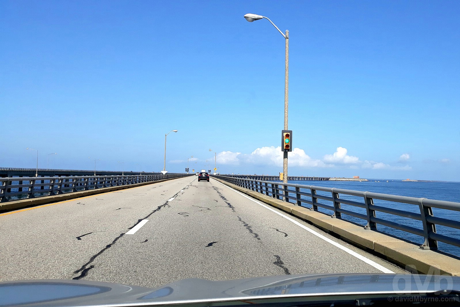
CHESAPEAKE BAY BRIDGE-TUNNEL || Northbound on the Chesapeake Bay Bridge–Tunnel spanning Chesapeake Bay, Virginia. October 7, 2018.
Officially called the Lucius J. Kellam Jr. Bridge–Tunnel since August 1987 but still widely known as the Chesapeake Bay Bridge–Tunnel, this engineering marvel, which required the creation of 4 artificial islands, runs for 17.6 miles (28.3 kilometres) shore to shore, from Virginia Beach in the south to the southern tip of the Delmarva Peninsula in the north, via a combination of parallel low-level trestle bridges (each supported by some 2,500-plus piles) & 2 1-mile-long single-tube tunnels (the tunnels were required to allow maritime traffic to continue to use the dredged Chesapeake Bay shipping channels leading to the Atlantic, although not without incident – three major ship accidents over the years have caused the bridge tunnel system to be closed). One of only 10 bridge-tunnel systems in the world and replacing a ferry service that had crossed the bay since the 1930s, the present northbound carriage, seen here, opened for passage in April 1964 after 42 months of construction and at a cost of $200 million. A first expansion, costing $250 million, was completed in April 1999, the new present-day southbound carriage opening after a 46-month construction period and allowing, for the first time, 2 lanes in each direction on the bridges (the two tunnels are still only 2-lane). A second expansion is presently underway to add a second parallel tunnel at the southern end while a third expansion to add a parallel tunnel at the northern end is earmarked to begin in 2035, the completion of which will see the entire length become four lane highway shore to shore. Built with private finds and financed solely by toll revenue (our south to north crossing cost us $13), the Chesapeake Bay Bridge–Tunnel has been crossed by some 130 million vehicles as of May 2018. Unlike the 23.8-mile-long (38.5 kilometre) Lake Pontchartrain Causeway in Louisiana, which we crossed on Day 17 of our Epic US Road Trip 2017, options for stopping while crossing the Chesapeake Bay Bridge–Tunnel these days are non-existent (a popular stop near the southern end, the Sea Gull Pier, closed to the public in 2017 to facilitate the present expansion project), meaning pictures of the crossing are limited to dashboard point, shoot & pray captures, just like this effort seen here.
– dangerousroads.org commenting on the Chesapeake Bay Bridge–Tunnel
The Chesapeake Bay Bridge–Tunnel deposited us back onto the Delmarva Peninsula, the finger of land shared by the states of Maryland, Virginia & Delaware, Delmarva being an acronym for the three states that occupy it. It didn’t take us long to cover the 75 miles (121 kilometres) required to cross, from east to west, the peninsula last year, but, and allowing for a pit stop in Ocean City, Maryland, it took us a while longer to cover the 200 miles (322 kilometres) required to traverse it south to north this time around. A 65-mile (105 kilomtere) drive up the peninsula’s US Route 13 brought us to the end of our time in Virginia at the Virginia/Maryland state line. It was also to signal the end of our time in the South, so says the unmissable sign at Dixieland.
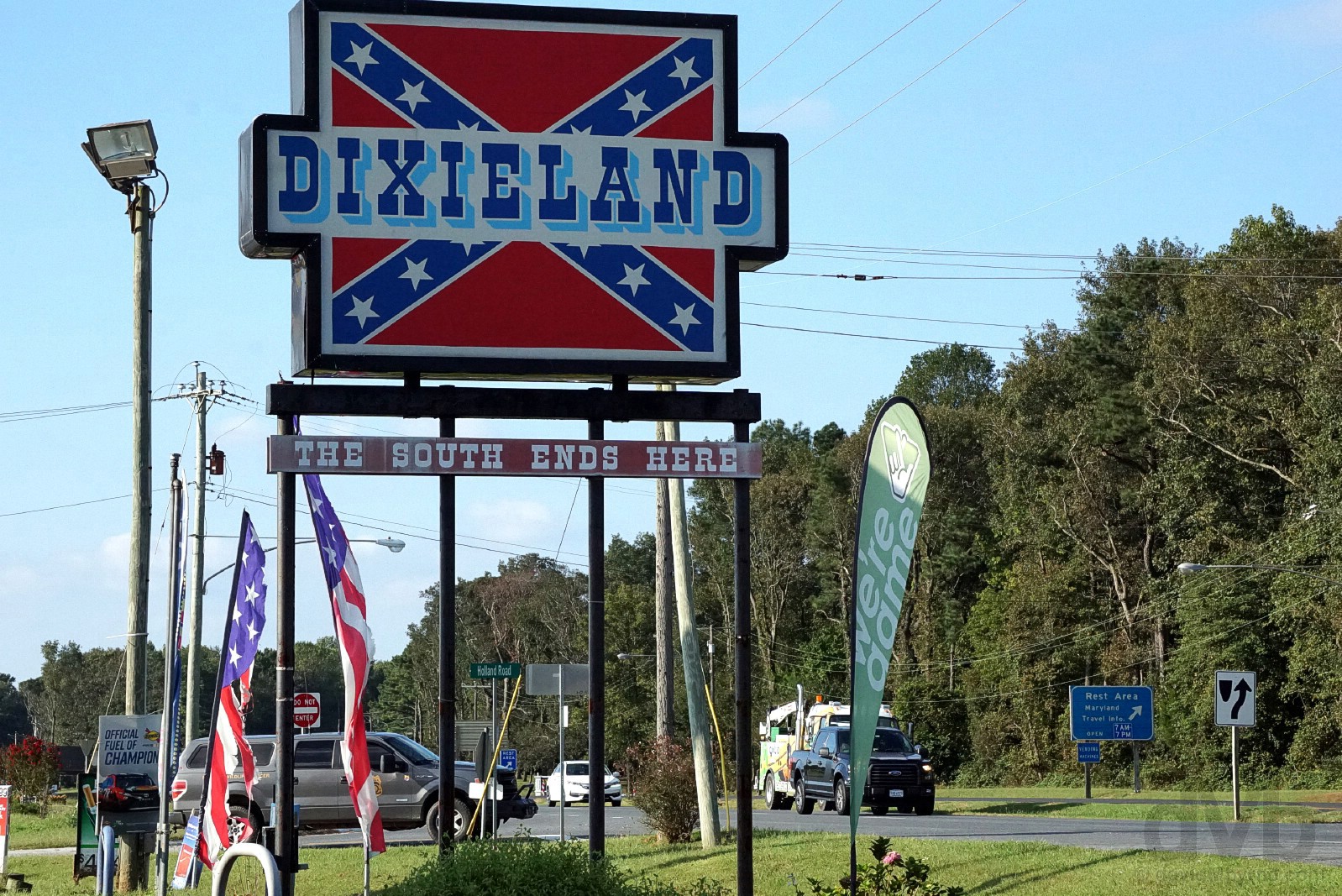
DIXIELAND || Dixieland – The South Ends/Starts Here. At the Virginia/Maryland state line on the Delmarva peninsula, New Church, Virginia. October 7, 2018.
While some larger retailers – among them Walmart, Sears, Amazon and Ebay – are falling over themselves to be politically correct and thus no longer sell Confederate flag-branded merchandise, Dixieland owner J. R. Pikulsky continues to do so – his convenience store and gas station, located on the Virginia side of the Eastern Shore’s Virginia-Maryland state line, even uses the ‘Stars and Bars’ as a logo in a celebration of Southern heritage. The massive Dixieland sign fronting the property is certainly something of a Delmarva Peninsula landmark and a great photo op.
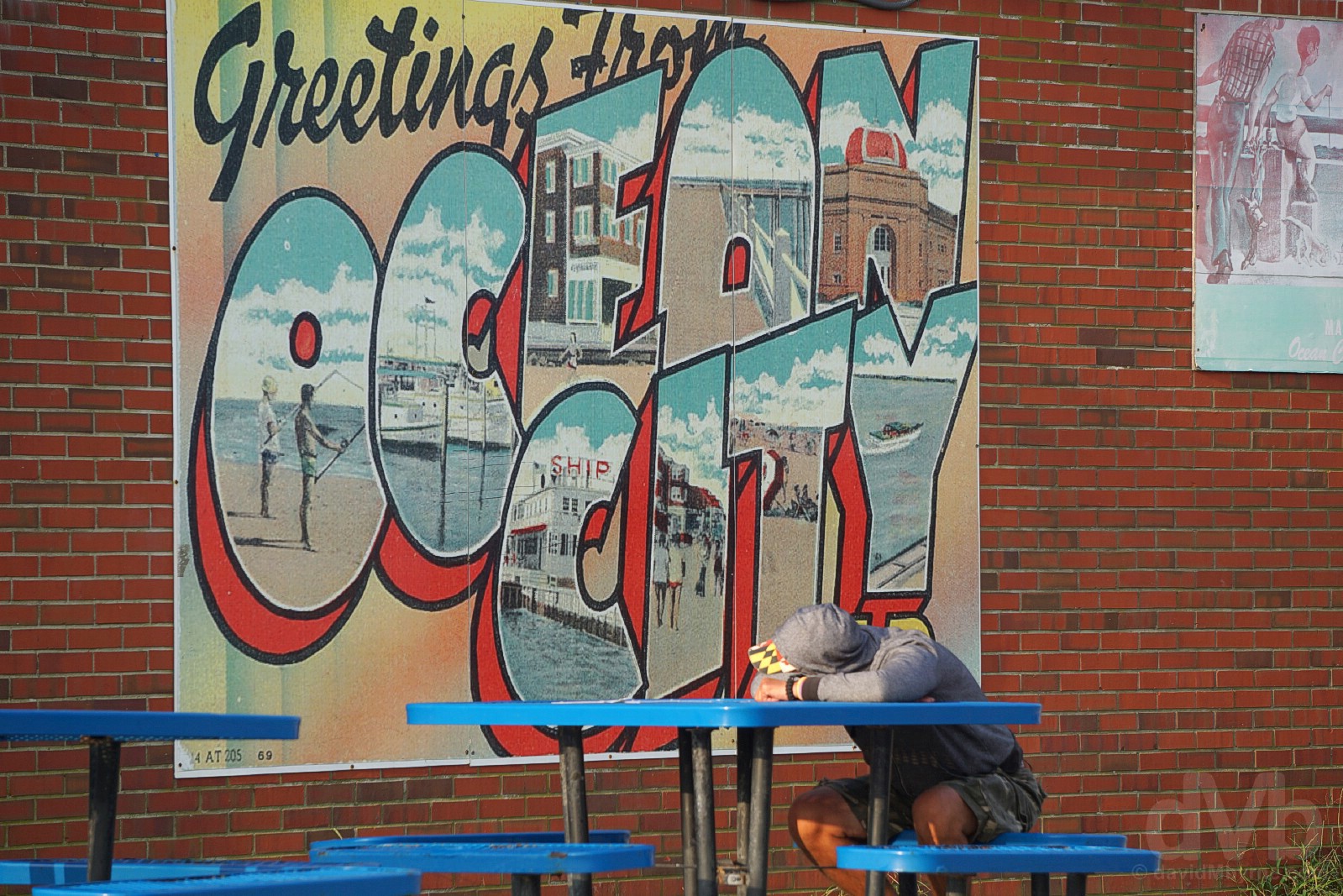
Ocean City
Maryland (MD) || It’s not AC, which is a good start. A much less crass and much more agreeable version of New Jersey’s Atlantic City, OC, founded in 1875, is Maryland’s very own boardwalk-boasting seasonal Atlantic Ocean family-friendly resort town; pulling in some 8 million visitors a year makes it one of the US East Coast’s largest seasonal vacation hubs, and there’s not a casino to be had for love nor money.
Although efforts to establish a resort on the narrow Atlantic-facing barrier spit/island of Fenwick stretch back to the 1830s, this place has been attracting beach vacationers since the late 1860s when the first beachfront cottages and boarding houses appeared. Known as “The Ladies’ Resort to the Ocean” prior to 1875, when the city’s first major hotel, the Atlantic Hotel, was built, rapid 20th-century expansion, especially in the post WWII years and again in the 1970s with the construction of thousands of high-rise condominium units, has morphed the city into what it is today, that being a seasonal resort town with a year-round population of some 7,000, a number that swells to nearly 350,000 during busy summer weekends.
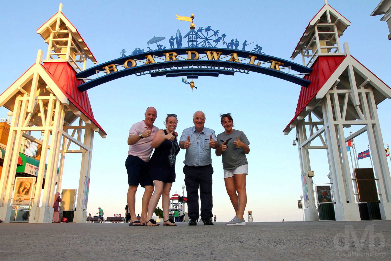
Thumbs-up under the Boardwalk Arch in Ocean City, Maryland. October 7, 2018.
Obviously we took many a thumbs-up picture – at state lines, monuments etc. – but this is my pick of the lot captured on the last night of the trip on a beautiful evening in OC.
Image || Early morning on the beach in Ocean City, Maryland.
“I liked OC. We didn’t spend long here, but we still gave it sufficient opportunity to rub me up the wrong way à la Atlantic City. Yes, of course there’s the usual oceanfront resort tackiness – Ripley’s Believe it or Not! is here, enough said – but OC didn’t have the AC effect (and nor does it have its casinos, its filthy sea gulls or its overbearing neon, noise & kitsch), and that was good enough for me. I even bought an OC t-shirt.”
Day 10 || October 8 2018
Route || Ocean City to New York Stewart International Airport
Miles (Kilometres) Driven || 324 (521)
Today’s Highlight || Early morning Ocean City
This day was far & away the busiest day of all on the road. It needed to be, and it was always going to be. But before we succeeded in bringing the trip to an end 320-plus miles north of here in New York state, there was a need to get some presentable pictures from Ocean City. And OC duly obliged by being much more photogenic early on this day than it was late on the previous evening.
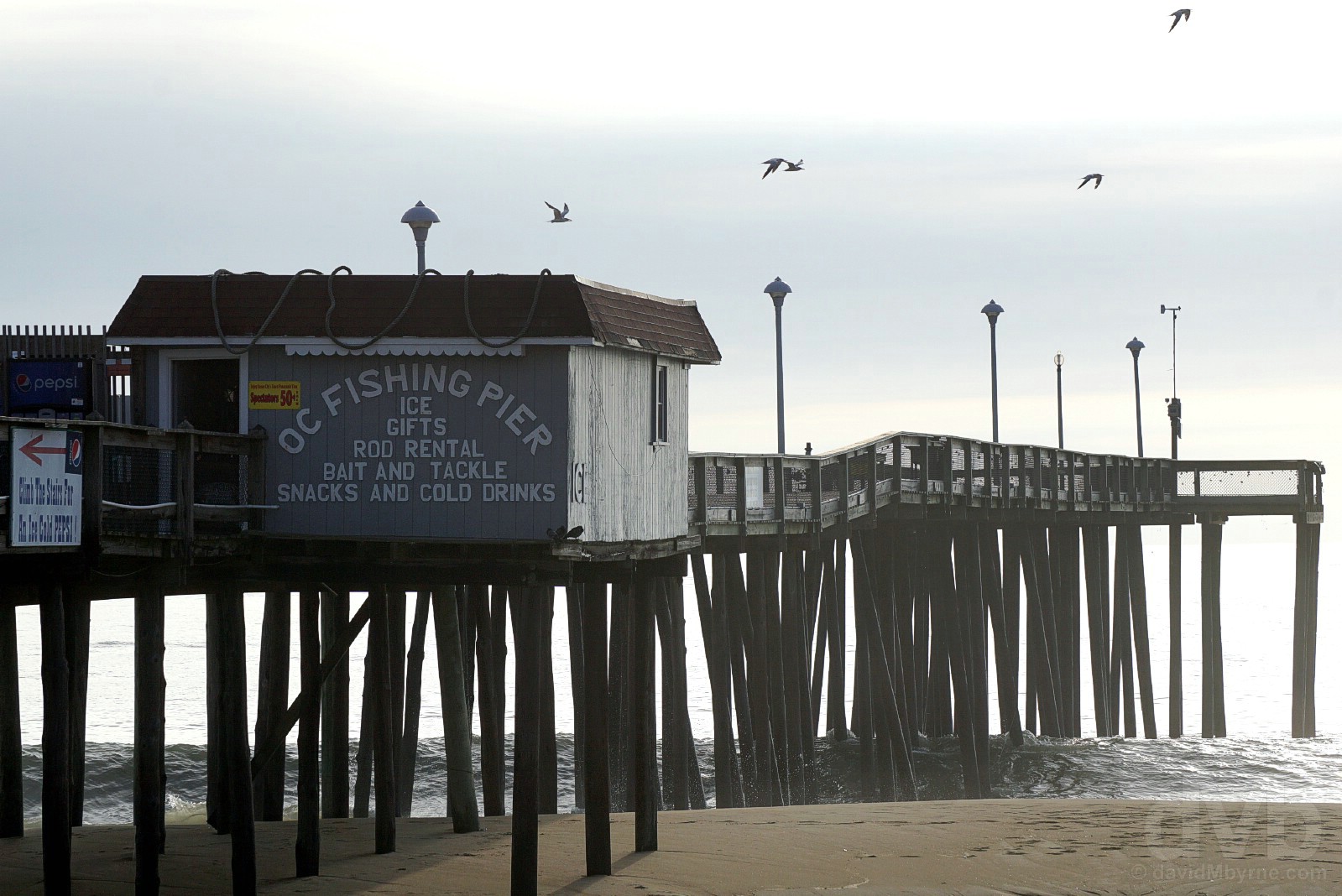
Early morning by the OC Fishing Pier, Ocean City, Maryland. October 8, 2018.
– ococean.com, the official site of Ocean City claiming that ‘the fun never ends’ in OCMD
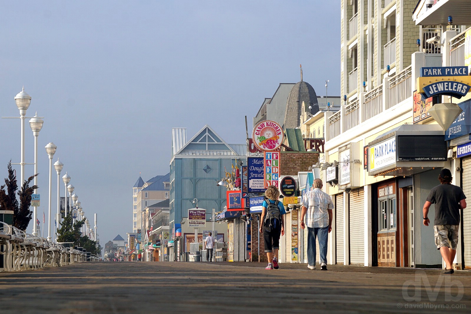
THE OCEAN CITY BOARDWALK || Early morning on The Boardwalk in Ocean City, Maryland. October 8, 2018.
Ocean City itself extends for over 9 miles, south to north, an almost continuous string of hotels, motels, apartment houses, shopping centres, residential communities and high-rise condominiums covering the narrow spit of Atlantic-facing Fenwick Island. The Ocean City Boardwalk occupies the 2.25-mile (3.6 kilometre) southern portion of the spit, its numerous shops, resultants, bars & family-friendly attractions making it both the nexus of OC’s tourist offering and the city’s main shopping & entertainment district. Originally called Atlantic Avenue, it was first constructed in 1902 and has been rebuilt or refurbished following storm damage in 1962, 1985 &, most recently, 2012 when Hurricane Sandy, a.k.a. Superstorm Sandy, had the audacity to blow through as violently as she did.
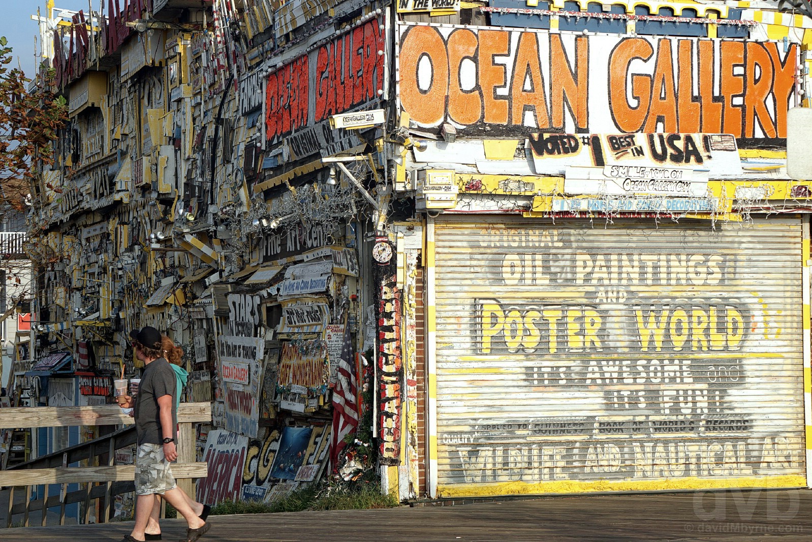
OCEAN GALLERY || The Ocean Gallery on the Boardwalk in Ocean City, Maryland. October 8, 2018.
‘It’s astounding!’ It’s ‘Wild & Crazy!’ And it’s ‘Globally Famous!!’ (2 exclamation marks). That’s just some of the hyperbole employed by the Ocean Gallery themselves in describing what is the ‘#1 Boardwalk attraction’, that latter claim by none other than USA Today. Having recently – August 2017 – celebrated 50 years in business, the eclectic gallery (which has a very popular Boardwalk webcam) started when its extravagant owner, Joe KroArt, came to Ocean City one summer with his paintings to sell them on the Boardwalk. Now a city & Boardwalk institution and easily one of OC’s most instantly recognizable fixtures, the one-of-a-kind facade of the gallery, adorned with recycled pieces of buildings from all around the country, is designed to grab attention, and grab attention it certainly does.
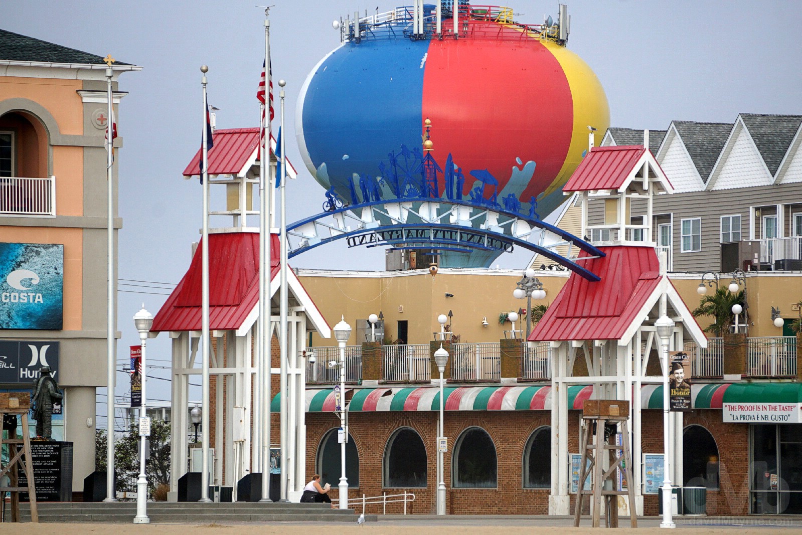
BEACH BALL WATER TOWER || The Boardwalk Arch & the landmark Beach Ball Water Tower in Ocean City, Maryland. October 8, 2018.
Another attention-grabbing OC landmark, the massive Beach Ball Water Tower is a relatively new fixture on the city skyline having only been erected in 2016, its distinctive paint job an effort to ‘brighten up the views’.
The rolling Atlantic surf does its worst, meaning the city of OC is fighting a constant battle against beach erosion, periodic multi-million dollar out-of-season beach restoration projects a necessity in order to save OC’s most valuable asset. The beach is broad (there’s plenty of room for all the holidaymakers who flock here) and must be crossed in order to get to where the Atlantic waves roll in around the pilings of yet another city landmark, The OC Fishing Pier.
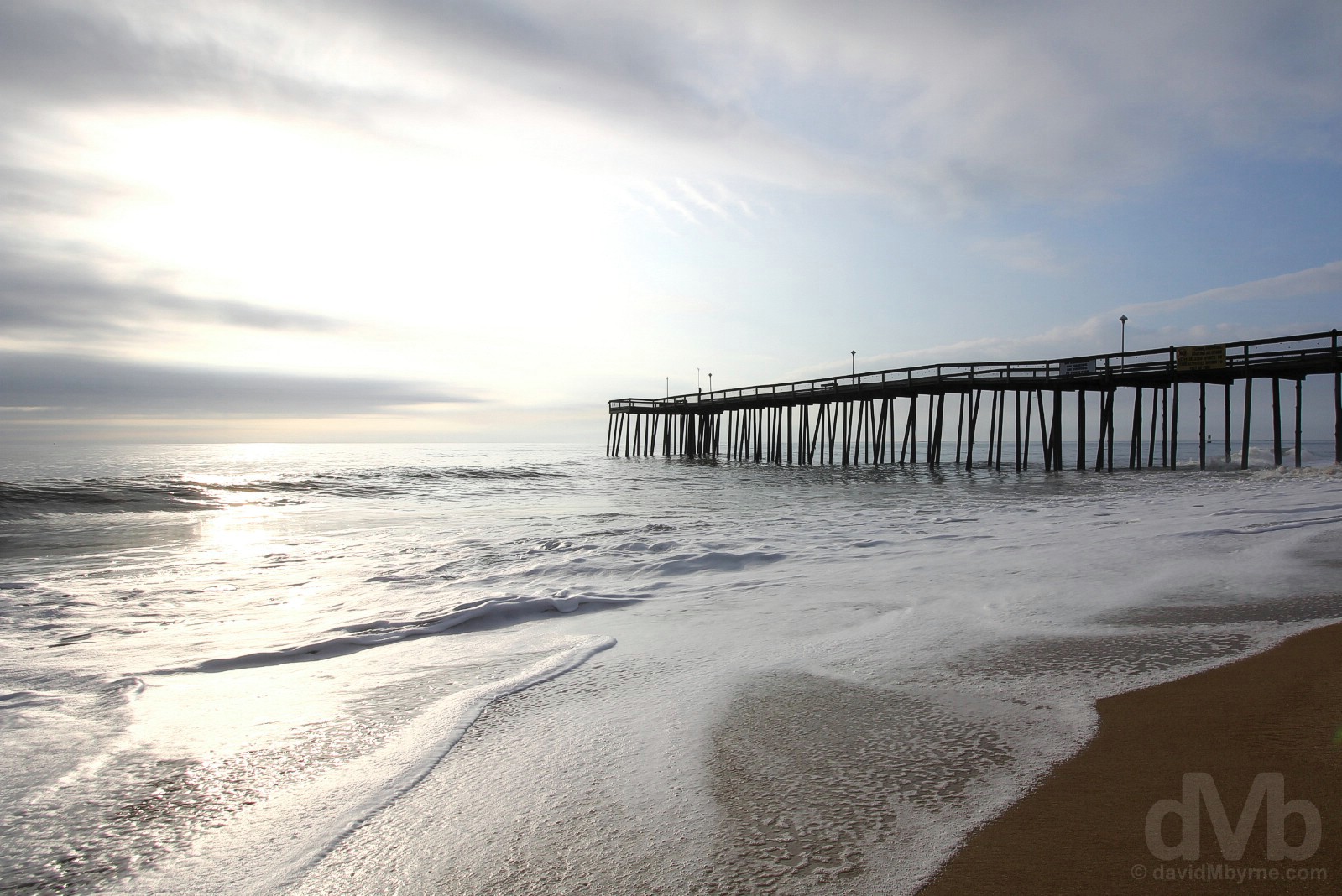
The OC Fishing Pier, Ocean City, Maryland. October 8, 2018.
A fixture on the OC landscape for over a century, there has been a fishing pier here since 1907 when its erection was considered a big achievement for the then developing resort. However, and as one might imagine, any pier here leads a perilous existence – it has been damaged or destroyed several times in its history, most recently by Hurricane Sandy in late October 2012 when huge waves demolished much of the seaward end of the iconic structure. Anchored by the Jolly Rodger Amusement Park and its iconic Ferris Wheel, another OC landmark, and rebuilt, yet again, following Sandy, the rickety-looking structure extending out in to the Atlantic surf today is the only dedicated fishing pier in a city with a long history of fishing, both commercial and recreational, and one which bills itself as the ‘White Marlin Capital of the World’, something the numerous displays of preserved trophy catches near the very southern end of the OC Boardwalk will attest to.
The OC Love
I liked OC. We didn’t spend long here, but we still gave it sufficient opportunity to rub me up the wrong way à la Atlantic City. Yes, of course there’s the usual oceanfront resort tackiness – Ripley’s Believe it or Not! is here, enough said – but OC didn’t have the AC effect (and nor does it have its casinos, its filthy sea gulls or its overbearing neon, noise & kitsch), and that was good enough for me. I even bought an souvenir OC t-shirt, mine for $7 in one of the many tourist-orientated Nothing-Over-$5 stores lining the OC Boardwalk. Go figure.

Fueling up. Breakfast in Denny’s in Ocean City prior to hitting the road for the 324-mile (521 kilometre) drive north to New York Stewart International Airport. October 8, 2018.