Ireland
Pictorial Highlights Of A 10-Day Road Trip Around Ireland, The Emerald Isle
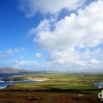
Dingle Peninsula, Co. Kerry, Ireland. August 28, 2014
– George Bernard Shaw (1856-1950), Irish playwright, critic, & political activist
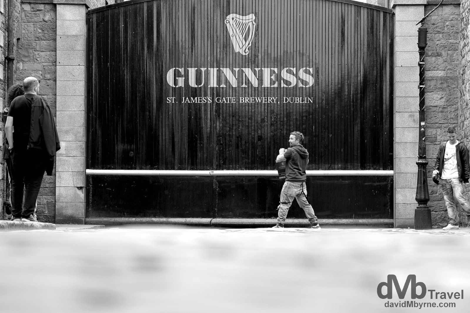
St. Jame’s Gate, the home of Guinness. Dublin, Ireland. September 1, 2014.
I‘d road tripped in Ireland a few times before, chaperoning overseas visitors around this gorgeous little island I call home. Every trip has been enjoyable – road trips always are, even those taken over familiar ground. But there was something special about the road trip I’ve just completed with Ian of BorderlessTravels.com. He was my guest for 10 days, the majority of which we spent touring the country pointing our cameras this way & that. Unbelievably the weather played ball (it rains here a lot which is why it – Ireland – is so green), we shared more than a few laughs (& beers), and for the most part Ian understood what the locals were saying. It was a memorable trip, one which gave me an even deeper appreciation for home. What follows is a day-by-day pictorial recap of our adventure.
– Carlo Goldoni
Ireland Road Trip || The Gallery
-

- Ballintoy Harbour, aka Pyke Harbour in HBO’s Game of Thrones, Causeway Coast, Northern Ireland. August 25, 2014.
-
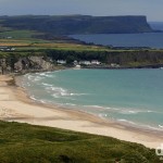
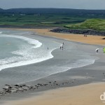
- Overlooking the 2 mile stretch of sand at White Park Bay, Causeway Coast, Co. Antrim. Northern Ireland. August 25, 2014.
-
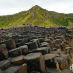
- The Giant’s Causeway, Causeway Coast, Co. Antrim, Northern Ireland. August 25, 2014.
-
- Old Bushmills Distillery, Bushmills, Co. Antrim, Northern Ireland. August 25, 2014.
-
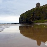
- Another well-known Game of Thrones scene location, Mussenden Temple as seen from Downhill Beach, Co. Antrim, Northern Ireland. August 25, 2014.
-
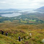
- On the Upper Diamond Hill Walk in Connemara National Park, Co. Galway, Ireland. August 26, 2014.
-
- Street signs and an old school telephone box in Westport, Co. Mayo, Ireland. August 26, 2014.
-
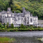
- Kylemore Abbey, Connemara, Co. Galway, Ireland. August 26, 2014.
-
- On the Sruffaunboy Walk in Connemara National Park, Co. Galway, Ireland. August 26, 2014.
-
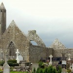
- The remains of the early 7th century Kilmacduagh Monastery outside the village of Gort, Co. Galway, Ireland. August 27, 2014.
-
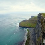
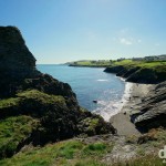
- A section of the coastline as seen from the Cliffs of Moher Walking trail, Co. Clare, Ireland. August 27, 2014.
-
- O’ Brien’s Tower &, in the distance, Moher Tower on Nags Head as seen from the Cliffs of Moher Walking trail, Co. Clare, Ireland. August 27, 2014.
-
- Surfers in the water of the beach in Lahinch. Co. Kerry, Ireland. August 27, 2014.
-
- Wild Atlantic Way signage & ominous clouds hanging over the Conor Pass, the highest mountain pass in Ireland. Dingle Peninsula, Co. Kerry, Ireland. August 27, 2014.
-
- Strand Street, Dingle, Dingle Peninsula, Co. Kerry, Ireland. August 28, 2014.
-
- Slea Head scenery on the Dingle Peninsula, Co. Kerry, Ireland. August 28, 2014.
-
- The cross at Slea Head, Dingle Peninsula, Co. Kerry, Ireland. August 28, 2014.
-
- Gallarus Oratory, Dingle Peninsula, Co. Kerry, Ireland. August 28, 2014.
-
- Kilmalkedar Church, Dingle Peninsula, Co. Kerry, Ireland. August 28, 2014.
-
- McCarthy’s Mor, the famous ‘castle on the beach’, in Ballinskelligs, Co. Kerry, Ireland. August 28, 2014.
-
- Portmagee as seen from Valencia Island, Co. Kerry, Ireland. August 29, 2014.
-
- The Skellig Islands as seen from Bray Head car park on Valencia Island, Co. Kerry, Ireland. August 28, 2014.
-

- Street art on Pine Street in Cork City, Co. Cork, Ireland. August 29, 2014.
-
- A sheltered section of Cobh Harbour, Co. Cork, Ireland. August 29, 2014.
-
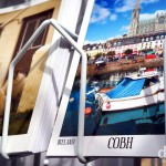
- Postcards on sale in Cobh, Co. Cork, Ireland. August 29, 2014.
-
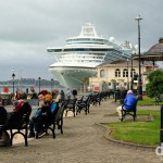
- The cruise liner Ruby Princess docked in Cobh, Co. Cork, Ireland. August 29, 2014.
-
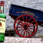
- Jameson Distillery, Midleton, Co. Cork, Ireland. August 30, 2014.
-

- Irish vs Scottish vs American. Whiskey tasting at the Jameson Distillery in Midleton, Co. Cork, Ireland. August 30, 2014.
-
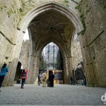
- Inside the 13th century Gothic Cathedral of the Rock of Cashel, Cashel, Co. Tipperary, Ireland. August 30, 2014.
-
- A portion of Kilkenny Castle as seen from a bridge over the River Nore in Kilkenny, Co. Kilkenny, Ireland. August 30, 2014.
-
- Wicklow Harbour, Co. Wicklow, Ireland. August 31, 2014.
-
- Coastal scenery in Wicklow Town, Ireland. August 31, 2014.
-
- Overlooking the harbour in Wicklow Town, Co. Wicklow, Ireland. August 31, 2014.
-
- Admiring the Round Tower in Glendalough, Co. Wicklow, Ireland. August 31, 2014.
-
- The Sally Gap, Co. Wicklow, Ireland. August 31, 2014.
-
- In the grounds of Powerscourt Estate, Enniskerry, Co. Wicklow, Ireland. August 31, 2014.
-
- Walking towards the Great Sugar Loaf in Co. Wicklow, Ireland. August 31, 2014.
-
- The Wicklow countryside as seen from atop the Sugar Loaf in Co. Wicklow, Ireland. August 31, 2014.
-
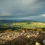
- The view towards Dublin from atop the Sugar Loaf in Co. Wicklow, Ireland. August 31, 2014.
-
- Georgian architecture on Leeson Street Lower, Dublin, Ireland. September 1, 2014.
-
- Moore Street, Dublin, Ireland. September 1, 2014.
-

- Graffiti on the Ha’penny Bridge spanning the River Liffey in Dublin, Ireland. September 1, 2014.
-
- Temple Bar, Dublin, Ireland. September 1, 2014.
-
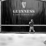
- St. Jame’s Gate, the home of Guinness. Dublin, Ireland. September 1, 2014.
-

- Guinness in the Gravity Bar in the Guinness Storehouse, St. Jame’s Gate, Dublin, Ireland. September 1, 2014.
-
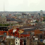
- A section of Dublin as seen from the Gravity Bar in the Guinness Storehouse, St. Jame’s Gate, Dublin, Ireland. September 1, 2014.
-
- An evening stroll (& long shadows) on the beach at Brittas Bay, Co. Wicklow, Ireland. September 2, 2014.
Interactive Road Trip Map & Selected Daily Highlights
Daily Highlights
Day 2
Causeway Coast, Co. Antrim (map C-G)
Day 3
Connemara, Co. Galway (map J & K)
Day 4
Cliffs of Moher, Co. Clare (map N)
Day 5
Dingle Peninsula, Co. Kerry (map P-S)
Day 6
Cobh, Co. Cork (map X)
Day 7
Cashel, Co. Tipperary (map a)
Day 8
Co. Wicklow (map c-f & h)
Day 9
Dublin City (map g)
– Dagobert D. Runes
Day 1 || August 24, 2014
Posting Location: Wicklow Town, Ireland
It’s day one of my road trip around Ireland with Ian, aka Yak, of BorderlessTravels.com We rendezvous in Dublin Airport in a few hours before heading north. We’ll be aiming to make it to Ballycastle, Co. Antrim with a stop off in Newgrange, Co. Meath, en route. We’re ready to get our shamrock on!
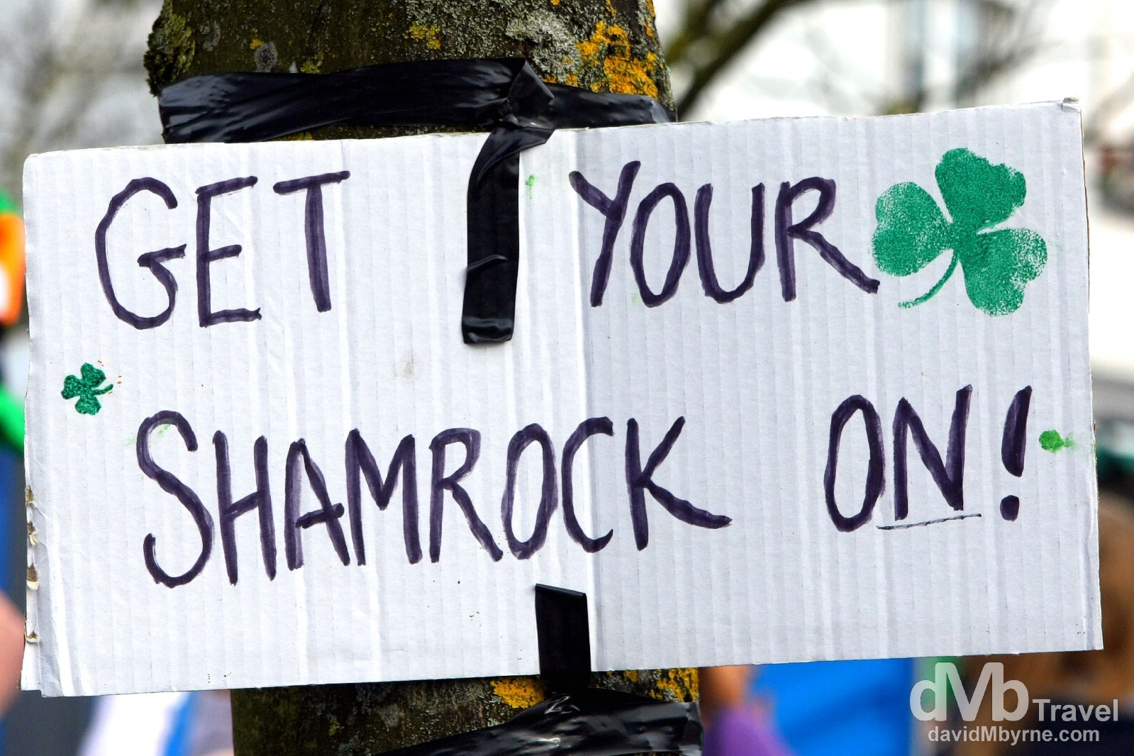
Get Your Shamrock On! Picture captured in Galway City on St Patrick’s Day (March 17) 2010
Ireland Road Trip – Day 2 Picture of the Day
White Park Bay, Causeway Coast, Co. Antrim, Northern Ireland
Day 2 || August 25, 2014
Posting Location: Bundoran, Co. Donegal, Ireland.
It has been a busy last few days. We’ve driven in and out of Northern Ireland, inexplicably getting lost a few times. En route we, & as I expected, hadn’t time to wait around for a guided tour of Newgrange (map marker A), a prehistoric monument & one of only 2 UNESCO World Heritage sites in the Republic of Ireland. Newgrange has been here a while – it was built in 3200 BC making it older than Stonehenge & the Egyptian Pyramids – so I doubt very much it’s going anywhere anytime soon. I’ll get there eventually but for now it’s still on my Ireland bucket list.
Ballycastle, Co. Antrim
Once we made it to Ballycastle, Co. Antrim (map marker B), we stumbled upon quite an unexpected party. Unexpected for us at least. It was the eve of the 400-year-old Ould Lammas Fair, Ireland’s oldest traditional fair. The party was in full swing & the carnival atmosphere addictive – crowds were out & everyone was jovial. It may have been a normal, sleepy Sunday night in the Republic but this particular northern town was alive & kicking on what was a holiday Sunday evening.
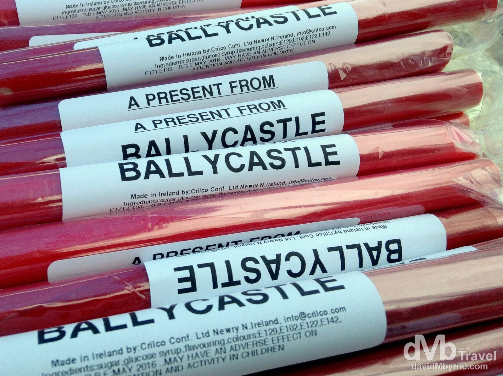
Stick of rock on sale one one of the many stalls lining Quay Road during the 400-year-old Ould Lammas Fair in Ballycastle, Co. Antrim. Northern Ireland. August 25, 2014. (iPod)
– IrishCultureandCustoms.com commenting on the Ould Lammas Fair
Causeway Coast || Causeway Coastal Route
The real highlight of this part of the world is undoubtedly the UNESCO-listed Causeway Coast, rated by Discover Northern Ireland as one of the Top Five Road Trips worldwide (they would say that). We spent today heading west, shuttling between coastal route highlights including, of course, the Giant’s Causeway & a few Game of Thrones filming locations, all before stopping for some whiskey tasting at the Old Bushmills Distillery, the oldest distillery in the world. All is good so far and it hasn’t even rained (much), although Ian, bless him, is struggling with the accents.
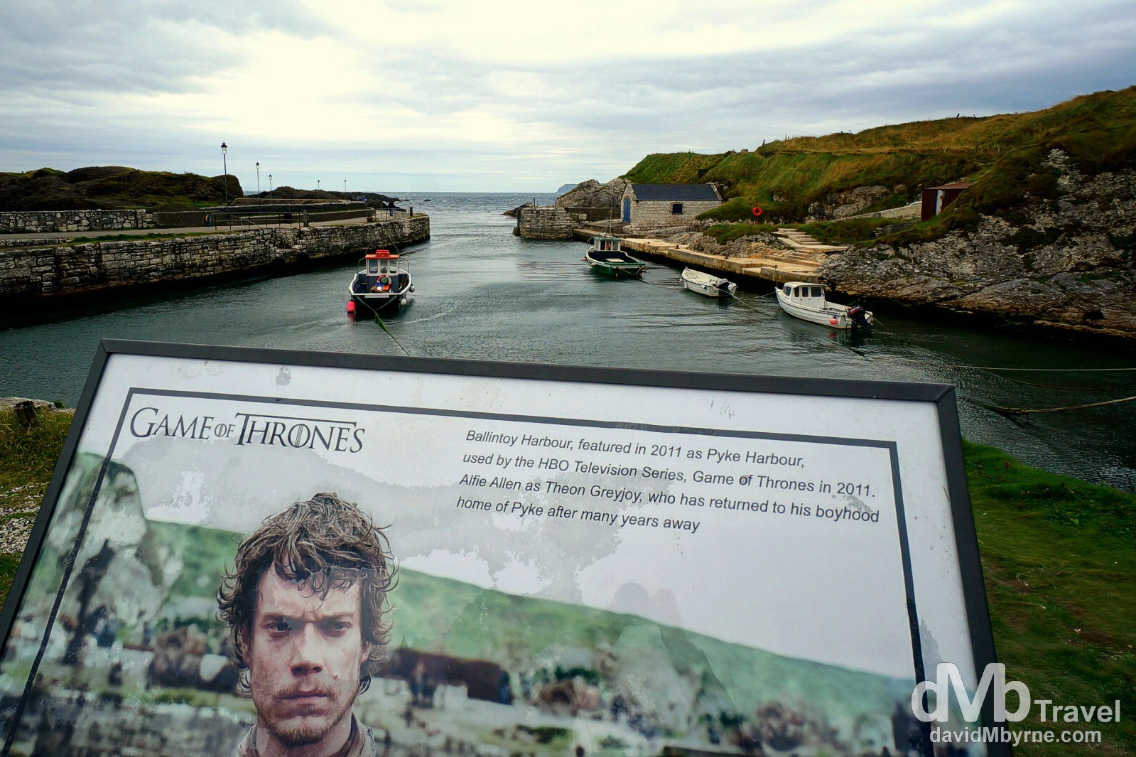
Ballintoy Harbour (map marker C), a.k.a. Pyke Harbour in HBO’s Game of Thrones. Just as Peter Jackson did by showcasing the New Zealand landscape with his Lord of The Rings trilogy, the US premium cable network HBO has extensively used the Causeway Coast locations to represent the fictional lands of the Seven Kingdoms of Westeros in the award-winning television series adaptation of George R.R. Martin’s Game of Thrones. Needless to say, GoT location tours abound but with a bit of Googling & with your own transport one can easily visit GoT sites like this at your own pace. Ballintoy Harbour, Causeway Coast, Northern Ireland. August 25, 2014.
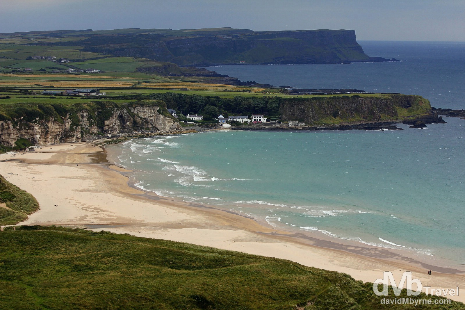
Overlooking the 3.3 kilometre stretch of sand at White Park Bay (map marker D), Causeway Coast, Co. Antrim. Northern Ireland. August 25, 2014.
The Giant’s Causeway
The Giant’s Causeway is an area of some 40,000 interlocking basalt columns, a spectacular rock formation that is one of Ireland’s most impressive and atmospheric landscape features. For centuries the unusual features of the Causeway, a national nature reserve and Northern Ireland’s only UNESCO World Heritage Site, has inspired artists, stirred scientific debate & captured the imagination of all those who see it. The ancients believed the causeway’s vast expanse of regular, closely packed, hexagonal stone columns were not a natural feature, but a path of stepping stones created by giants connecting Ireland to Scotland.
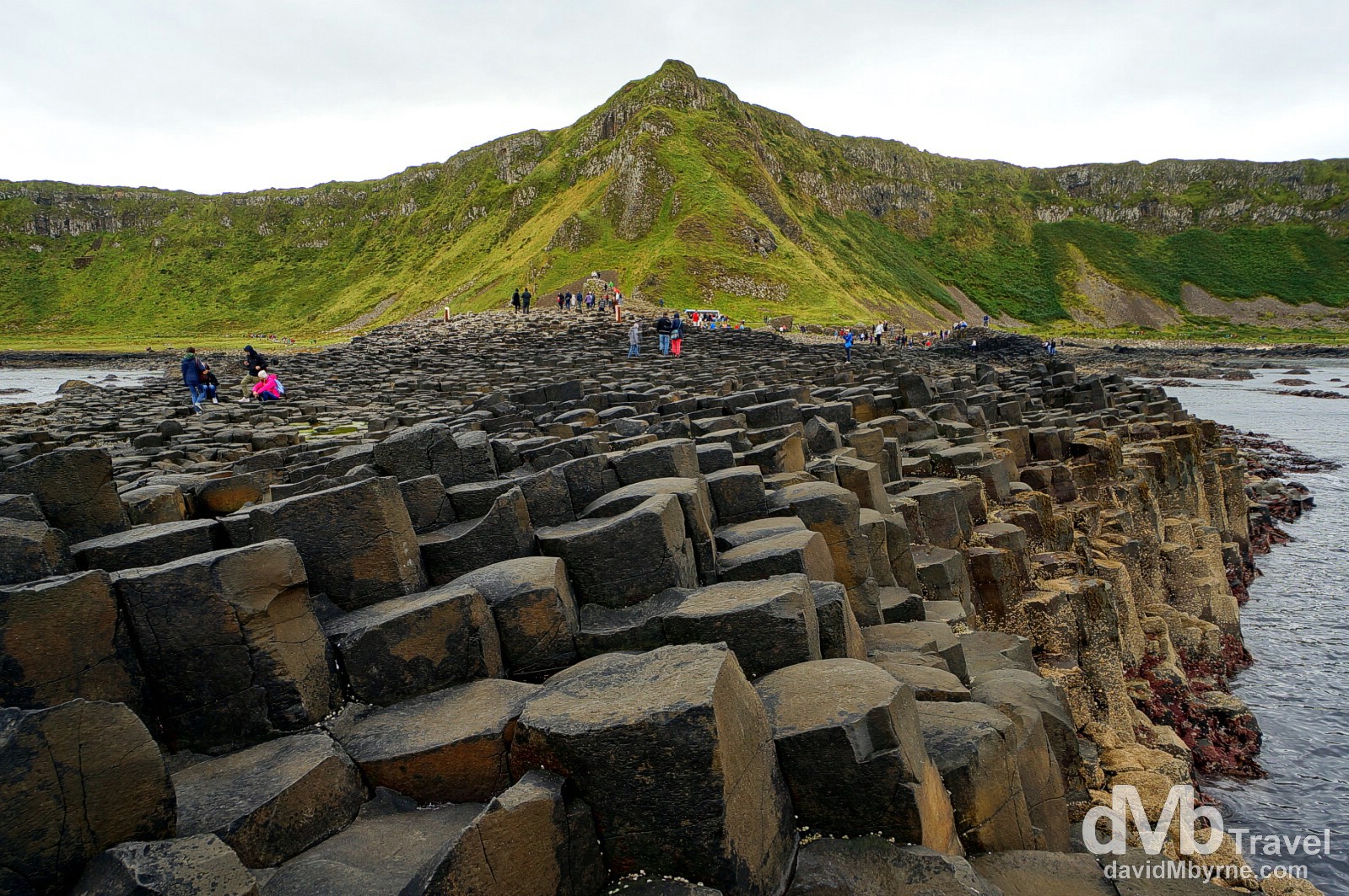
Flanked by the wild North Atlantic Ocean on one side and a stunning landscape of dramatic cliffs on the other, the Giant’s Causeway is the result of an ancient volcanic eruption. Most of the columns are hexagonal, although there are also some with four, five, seven and eight sides. The tallest are about 12 metres (36 ft) high, and the solidified lava in the cliffs is 28 metres thick in places. Declared a World Heritage Site by UNESCO in 1986, today the site Northern Ireland’s most popular tourist attraction – around 750,000 each year. If you can, try to visit midweek or out of season to experience it at its most evocative. Sunset in spring and autumn is the best time for photographs. The Giant’s Causeway, Causeway Coast, Co. Antrim, Northern Ireland. August 25, 2014. (Map marker E)
– UNESCO commenting on Giant’s Causeway and Causeway Coast
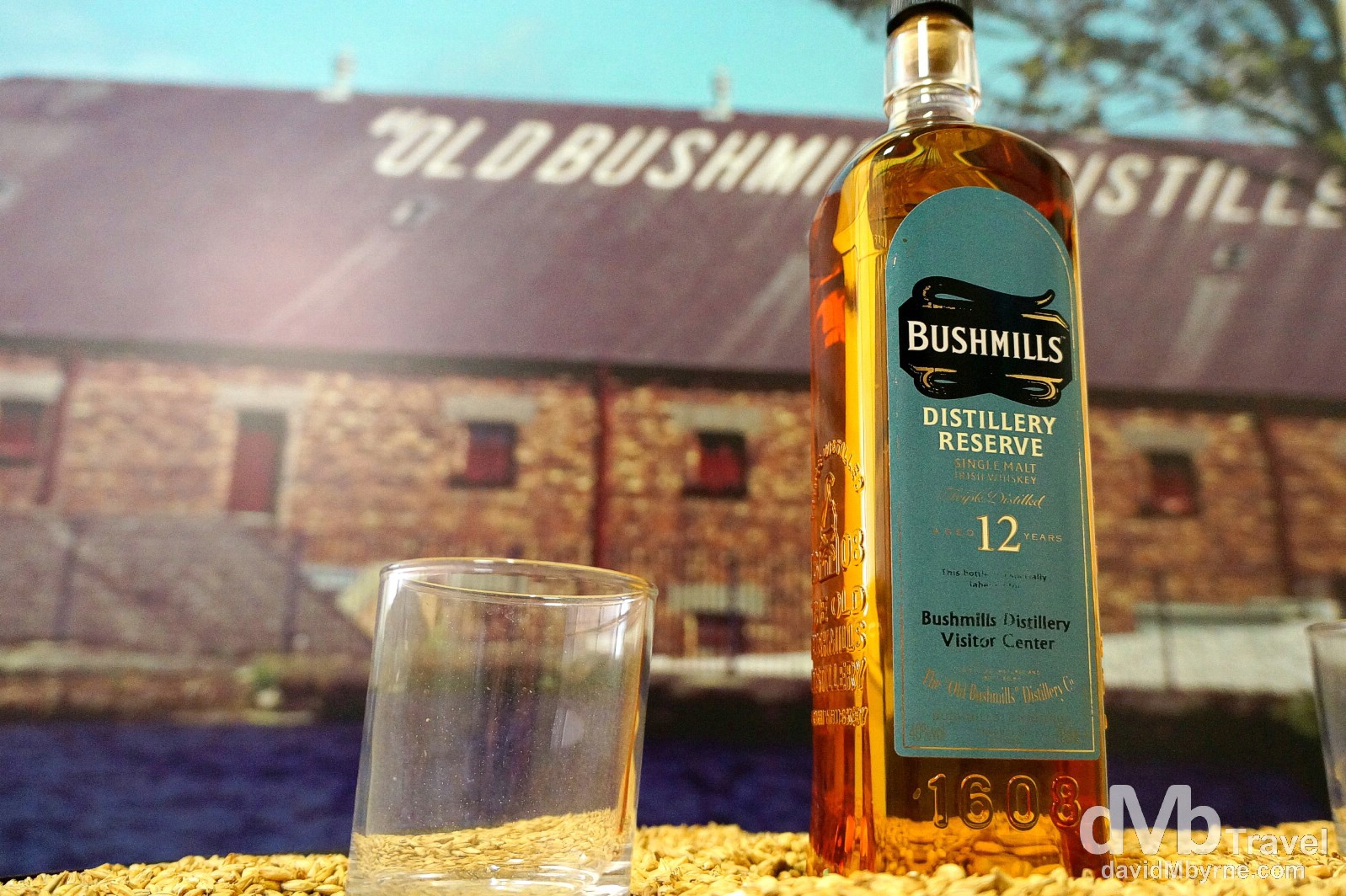
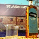
The Old Bushmills Distillery in Bushmills, Co. Antrim (map marker F). In here we got to learn about the art & process of whiskey making during a 75-minute tour of what Bushmills claim to be the world’s oldest distillery – they were granted the royal seal of approval to distill whiskey way back in 1608. That’s a long time ago. I’m not a whiskey fan but the tour was awesome, even if I had to pass on the obligatory post-tour glass of whiskey in the distillery bar. Oh and yes, ‘center’ is spelled the American way (‘er’, not ‘re’), a clear indication as to who buys this stuff – over 60% of Bushmills product is produced for export to the US. Bushmills, Co. Antrim, Northern Ireland. August 25, 2014.

Another well-known Game of Thrones scene location, the 11 kilomtre stretch of Downhill Beach (map marker G) served as Dragonstone in Season 2 of the series. The beach is overlooked by the small, circular Mussenden Temple. Built in 1785, the temple sits dramatically on a cliff some 40 metres above the beach overlooking the Atlantic Ocean. Downhill Beach, Castlerock, Co. Antrim, Northern Ireland. August 25, 2014.
Back in Euroland
Having driven Antrim’s Causeway Coast, we arrived in Bundoran, Co. Donegal (map marker H), this evening, back in the Republic of Ireland, back in Euroland & back to kilometre road signs (the U.K. are still on miles). There’s not a lot happening here in Bundoran. I expected it to be a bit livelier than it is. It’s still officially summer (just) but it looks and feels like winter – there are people around but not too many. We’ll leave here tomorrow, continuing south, & needless to say we’ll be sampling more (lots more) scenery, especially of the coastal kind as we get acquainted with Ireland’s newest attraction, its Wild Atlantic Way coastal drive from Sligo right down & around to Cork.
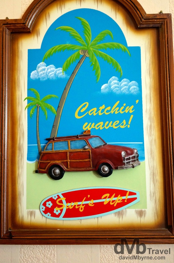
Catchin’ waves, Irish style. Surfing in Ireland? You bet. And for donning a wet suit & catching waves (or learning to surf) then Bundoran, Ireland’s surf capital & a popular seaside town that has been attracting tourists since as far back as 1777, is the place to be. Indeed, in 2012 National Geographic listed it as one of the world’s top 20 surfing towns. TurfnSurf Lodge, Bundoran, Co. Donegal, Ireland. August 25, 2014.
Day 3 || August 26, 2014
Posting Location: Knockcroghery, Co. Roscommon, Ireland
It was a long day of driving today. We spent most of road trip day 3 in Connemara, Co Galway. Situated at the very edge of Europe, on the west coast of Ireland, it is one of the country’s most natural, unspoiled regions. Regarded by some as the real emerald of the Emerald Isle, it was here that we passed through our first Gaeltacht (Irish speaking) region of the trip. We also took a short hike in the small Connemara National Park which was easily, & if you’ll pardon the pun, the highlight of the day.
Connemara National Park
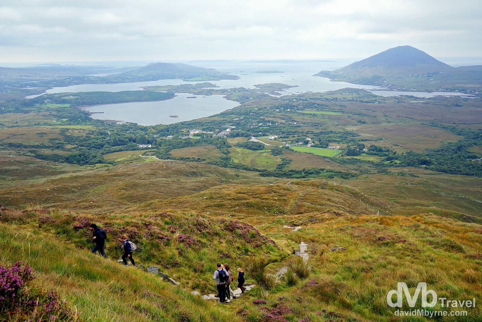
Walkers on the Sruffaunboy Walk in Connemara National Park, an area of mountains (hills really), bogs, heaths & grassland. The walks in the small National Park, one of only 6 in the Republic of Ireland, are short affairs – we completed the full 7 kilometre Diamond Hill circuit loop from the park’s Visitors Centre in a little over 2 hours. The name Connemara is Irish for ‘Inlets of the Sea’ & you’ll see why thanks to the amazing views towards the Atlantic Ocean from the park’s Diamond Hill walk. But only on a good day of course – on a typically cloudy, moody Connemara day there isn’t a whole lot to see except clouds & wet walkers. I know. I’ve been here before, without seeing much and getting nicely wet in the process. Thankfully today was different. Connemara National Park, Letterfrack, Co. Galway, Ireland. August 26, 2014.
– The Rough Guide to Ireland
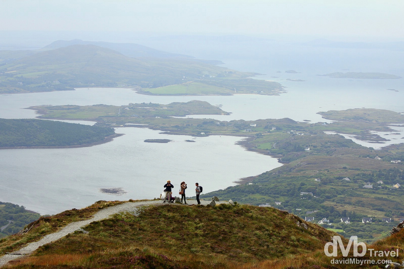
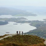
Outlets to the Atlantic as seen from the Upper Diamond Hill Walk in Connemara National Park (map marker K), Letterfrack, Co. Galway, Ireland. August 26, 2014.
The weather has been good so far. We haven’t even seen any real rain yet. The sun makes an appearance now & again but for the most part It has been overcast, good weather for Ireland. Ian has stated the obvious a few times, proclaiming that Ireland is ‘so green.’ He has also stated that what he has seen of southern Ireland thus far is ‘nicer’ than what me saw in the North. I tell him it’s gonna get better when tomorrow we hit the wild Atlantic Coast further south. I don’t think he believes me but I know that to be true.
A few more captures from today.
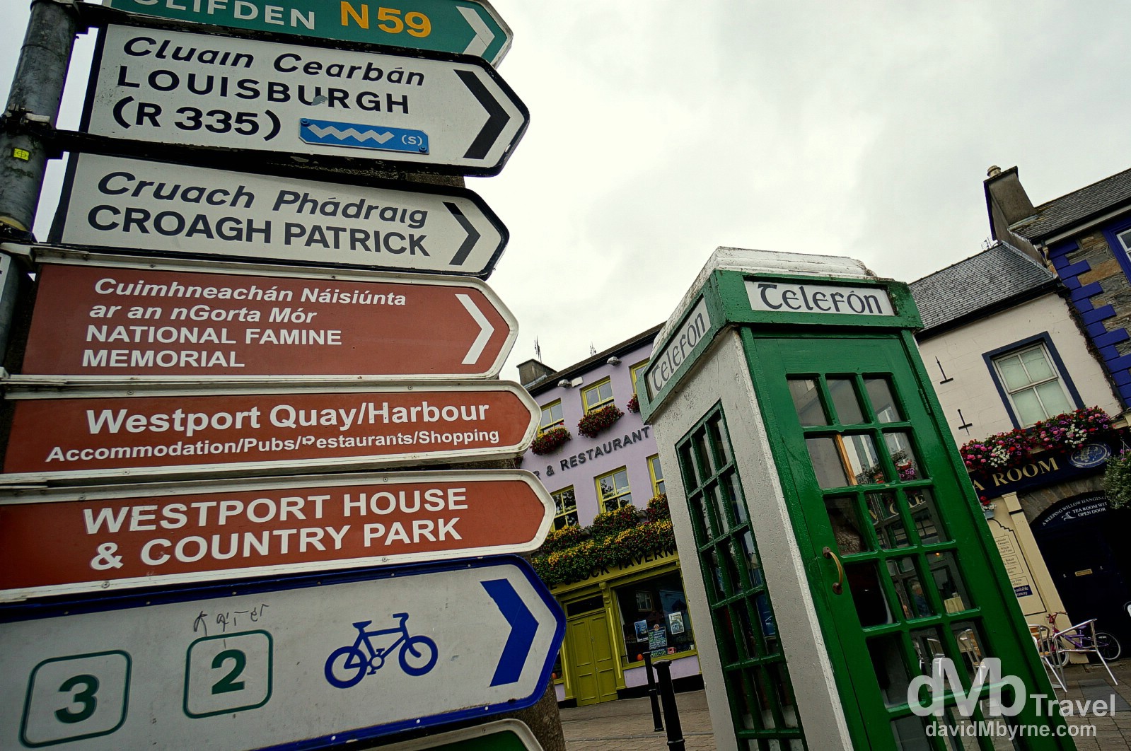
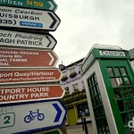
Street signs and an old school telephone box in Westport (map marker H), a pretty & tourist-heavy town in Co. Mayo. We stopped off for lunch en route to the Connemara region of neighbouring Co. Galway, Ian taking the opportunity to purchase himself a nice Irish tweed cap. He’s made up with his purchase. Westport, Co. May Ireland. August 26, 2014.
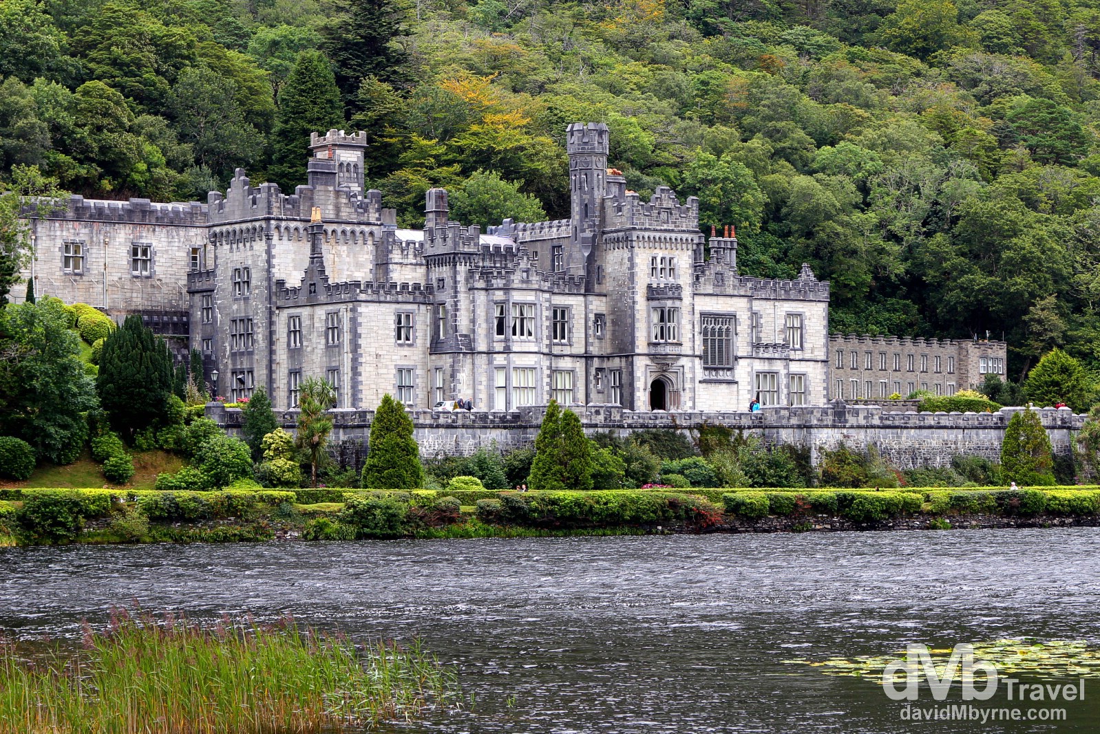
Kylemore Abbey, an iconic Connemara sight. Built between 1867 & 1871 as a private home for a wealthy family, today the Abbey is a Benedictine monastery (founded in 1920). I’d toured the Abbey 4 years previous, following the self-guided tour of the Abbey’s restored rooms learning about its history and tales of tragedy and romance as I went. Back then I also strolled around the 6-acre Victorian Walled Garden & poked my head into the small Neo-Gothic church, both of which are on-site and access to which is included as part of the €13 entry fee. We decided against paying that this time (I’d already been and Ian wasn’t too keen on paying €13 for a Downton Abbey-esque experience), deciding instead to capture, for free, the iconic image of the Abbey from across Pollacappul Lake before continuing on to the nearby Connemara National Park. Kylemore Abbey, Connemara, Co. Galway, Ireland. August 26, 2014. (Map marker J)
We made it to Knockcroghery, Co. Roscommon (map marker L), this evening. We’re not too far from Athlone, a vibrant town slap-bang in the centre of the country which sits on the banks of the River Shannon, Ireland’s longest waterway. Tomorrow we’ll head for Dingle on Kerry’s Dingle Peninsula with stops at Kilmacduagh Monastery, one of the finest collections of monastic buildings in Ireland, & the Cliffs of Moher, the country’s most visited natural attraction. The hits just keep on coming.
Day 4 || August 27, 2014
Posting Location: Dingle, Co. Kerry, Ireland
I spoke too soon. It rained today. Quite a lot. It was windy, too. Very windy on the Wild Atlantic Way, Ireland’s newest tourist attraction. The well signed 2,500 kilomerte coastal route, from Co. Donegal in the northwest to Co. Cork in the southeast, is billed as the longest coastal touring route in the world, a journey of inspiration along the wild, rugged absolute edge of Western Europe. So you’d sort of expect wind & rain. We got both. But we were lucky & managed to stay dry. The rain hadn’t started falling when we were poking around the early 7th century ruins at Kilmacduagh Monastery (map marker M), our first stop of the day, road trip day 4…
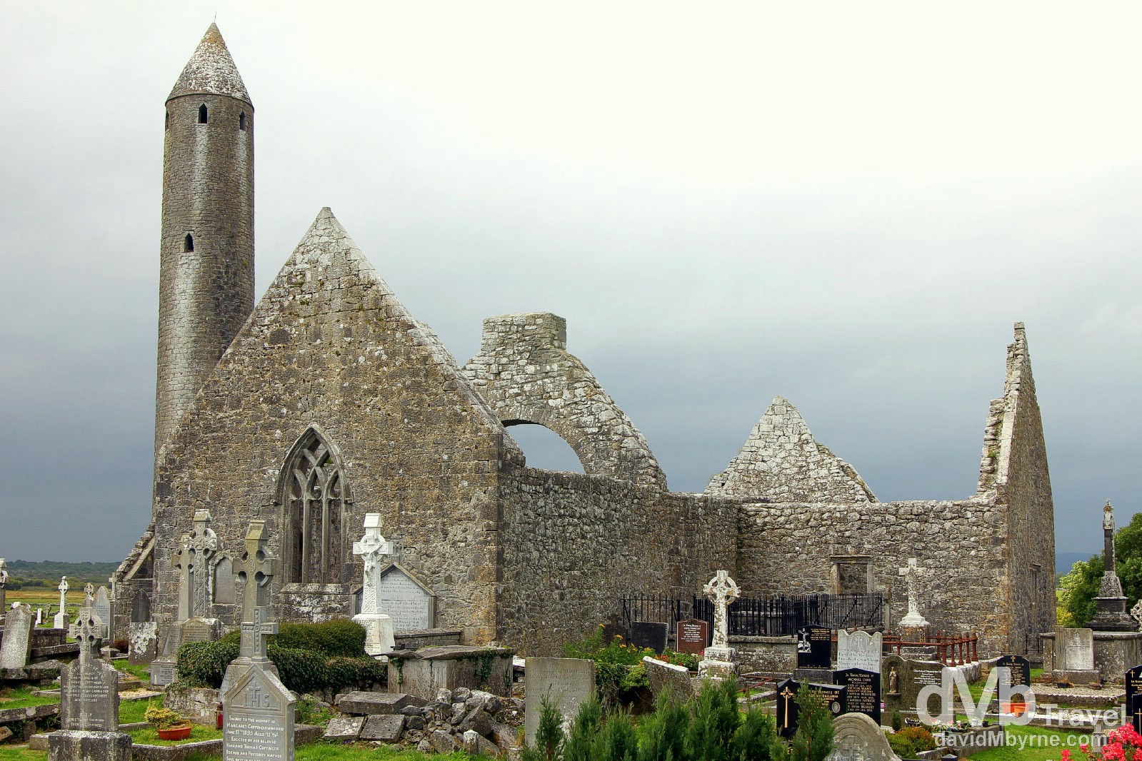
The remains of Kilmacduagh Monastery outside the village of Gort, Co. Galway. Saint Colman established a monastery here in the 7th century & what remains here today is one of the finest collections of monastic buildings in Ireland. Its churches were plundered in the 13th century but despite this the site remained the seat of a Bishop until the 16th century. The site’s main structure is of course its 12th century Round Tower. Notable for its lean of over half a metre from vertical, it stands over 30 metres tall with its only doorway some 7 metres above ground. It was used, as all round towers were, as a bell tower but also served on occasion as store-houses and as places of refuge in times of attack. Kilmacduagh Monastery, Co. Galway. Ireland. August 27, 2014.
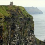
… it – the rain – had abated when we actually hit the coast, when we were staring out across the glorious expanse of the Atlantic Ocean from atop the towering, rugged Cliffs of Moher (map marker N), Ireland’s most visited natural attraction…
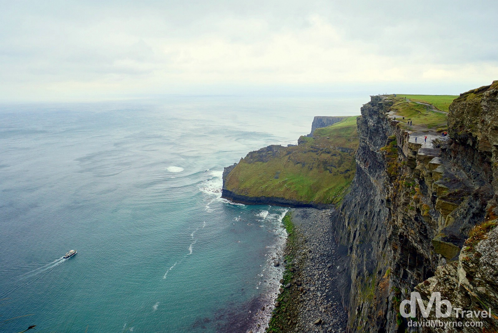
A section of the coastline as seen from the Cliffs of Moher Walking trail. Standing 214 metres (702 feet) high at their highest point, the Cliffs of Moher stretch for 8 kilometres (5 miles) along the rugged Atlantic coast of Co. Clare. Gawked at by almost 1 million people annually, the cliffs are the most visited natural attraction in Ireland & the second most visited attraction, natural or otherwise, in the whole country after the Guinness Storehouse in the capital, Dublin. Cliffs of Moher, Co. Clare, Ireland. August 27, 2014.
– An Irish Proverb
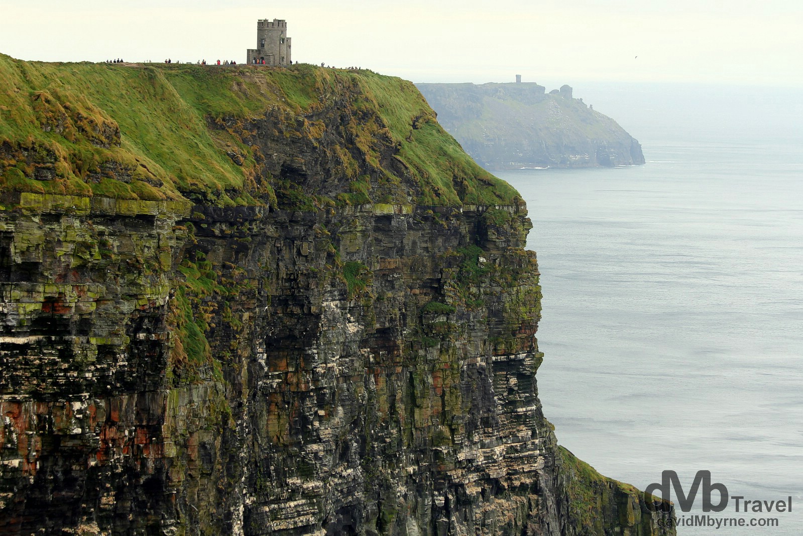
O’Brien’s Tower &, in the far distance, Moher Tower on Nags Head as seen from the Cliffs of Moher Walking trail. O’Brien’s Tower was built in 1835 by Cornelius O’Brien as a viewing point for tourists, a purpose it still serves today. For those not wanting to embark on the highly recommended Cliffs of Moher Walking Trail, the tower offers the best views of the cliffs. At the most southerly end of the cliffs, in the far distance, stands Moher Tower on Hags Head, a natural rocky promontory that is said to resemble a seated woman looking out to sea when viewed from this vantage point in the north. The cliffs, which formed some 320 million years ago, take their name form a ruined promontory fort ‘Mothar’ which was demolished during the Napoleonic wars to make way for Moher Tower, the small signal tower now standing at Nag’s Head. Cliffs of Moher, Co. Clare, Ireland. August 27, 2014.
… it was breezy down on the beach in Lahinch, Co. Clare (map marker O), perfect we imagined for beginner surfers catching their first waves…
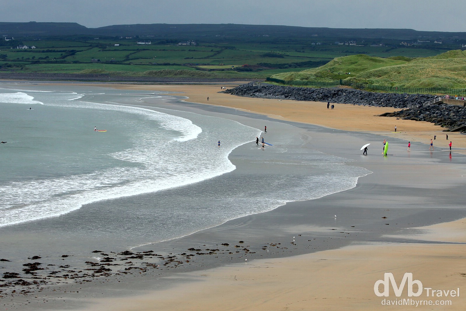
Surfers on the beach in Lahinch, Co. Clare, Ireland. August 27, 2014.
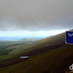
… it was crisp (blustery but crisp) when crossing the mouth of the Shannon River on the ferry from Killimer, Co. Clare, to Tarbert, Co. Kerry; and it was pretty nice crossing the Dingle Peninsula’s Conor Pass (map marker P), Ireland’s highest mountain pass. That was until we reached the pass itself at which stage the clouds had almost completely enveloped us.
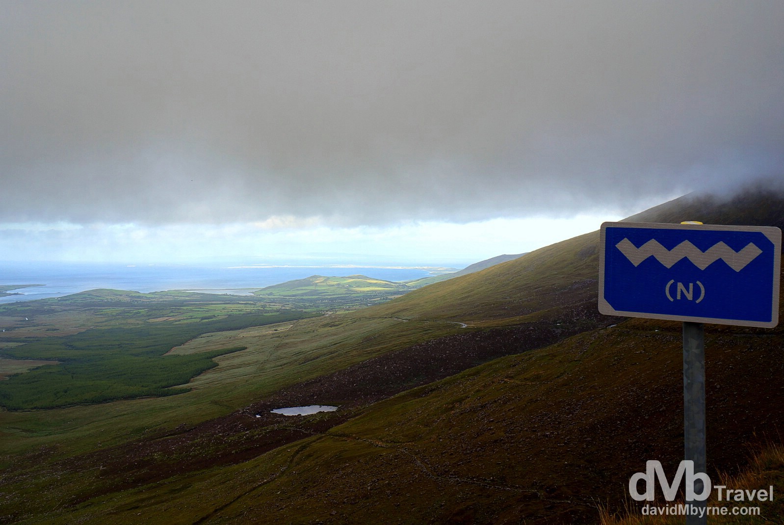
Wild Atlantic Way signage & ominous clouds hanging over the Conor Pass, the highest mountain pass in Ireland. Dingle Peninsula, Co. Kerry, Ireland. August 27, 2014.
All in all it was a good day, another full day of sightseeing & driving. We now find ourselves in Dingle (map marker Q) on the Co. Kerry peninsula of the same name. This is about as touristy a town as you’re likely to stumble upon in Ireland – colourful, traditional music-playing pubs & Aran sweater-peddling shops abound, all catering to the tourists who flock here. Of course Ian & I are two of those tourists, if only for one night, a night on which we plan on finding some craic & some of that aforementioned traditional music in one of Dingle’s many pubs. That shouldn’t be too hard. Getting up in the morning to drive the Dingle Peninsula & neighbouring Ring of Kerry might prove to be a bit more of a challenge. Here’s hoping the weather plays ball. So far, so good.
Days 5 & 6 || August 28 & 29, 2014
Posting Location: Fermoy, Co. Cork, Ireland
The last two days, road trip days 5 & 6, have been spent touring the Wild Atlantic Way coastline of two Kerry Peninsulas, a city (Ireland’s second), and a quaint harbour town in Co. Cork. It has been a busy few days. It has been fun. And it has, of course, been photogenic.
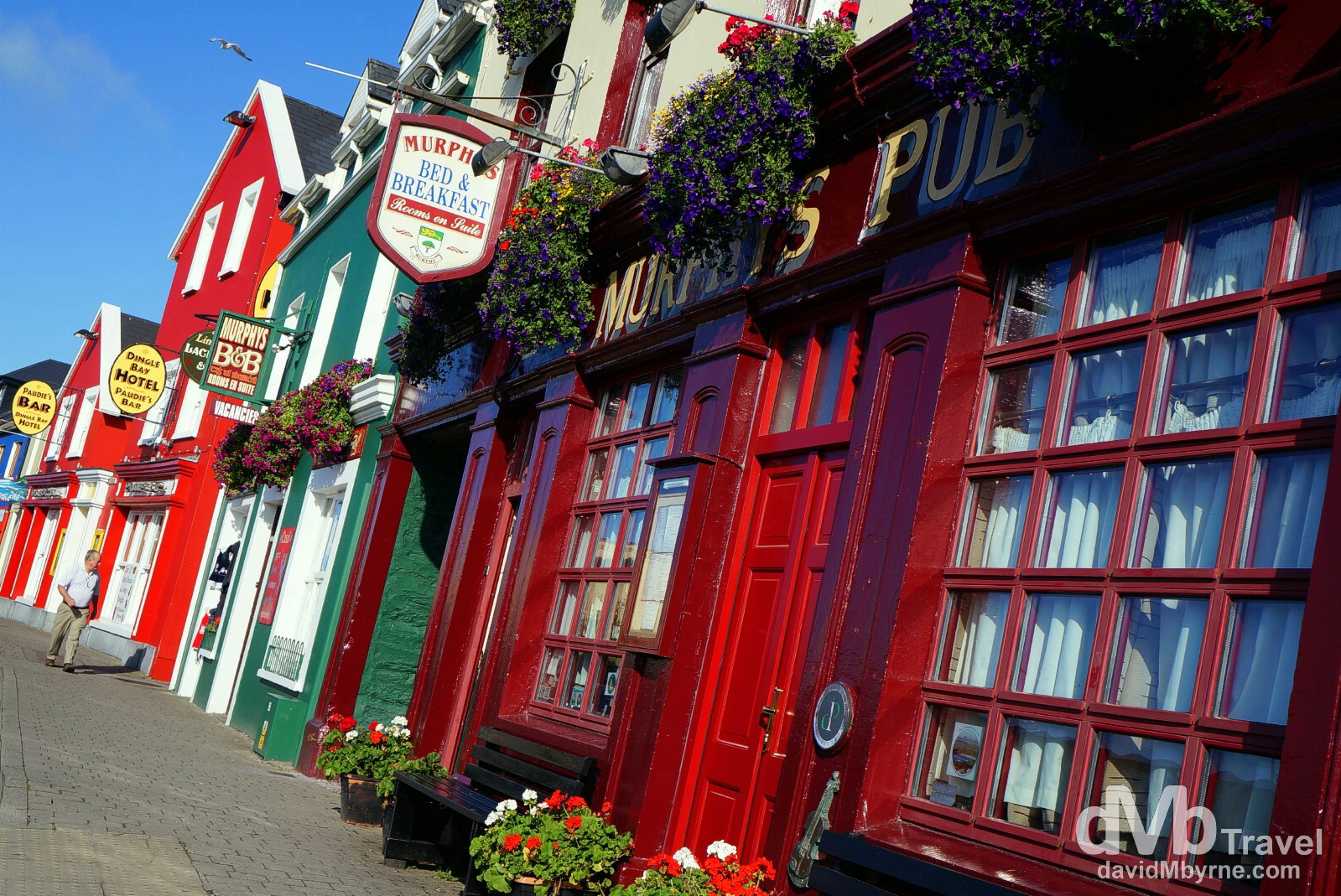
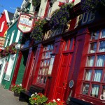
Another beautiful day, day 5 of the trip, & this one started with walk around charming, artsy, touristy Dingle town where I captured this picture of typically colourful premises (Bars & B&Bs) on Strand Street. Dingle, Dingle Peninsula, Co. Kerry, Ireland. August 28, 2014.
Dingle Peninsula || Peninsula Drive #1
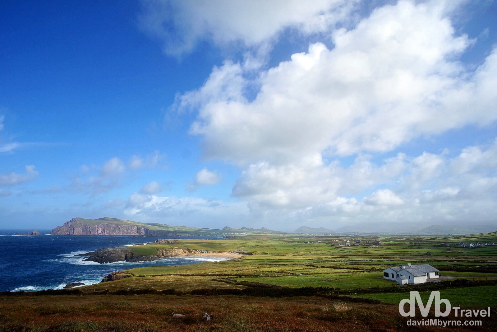
Co. Kerry’s Dingle Peninsula, the small finger of land jutting out into the Atlantic & surrounded by opal-blue waters, serves up one of the world’s most scenic drives, the classic 50 kilometre loop drive around Slea Head (map marker R) from Dingle town. Standing here, near Europe’s westernmost point, and staring across the sound to the Blasket Islands, is an unforgettable experience, even if the weather isn’t as good as it was for us on this day. Slea Head scenery on the Dingle Peninsula, Co. Kerry, Ireland. August 28, 2014.
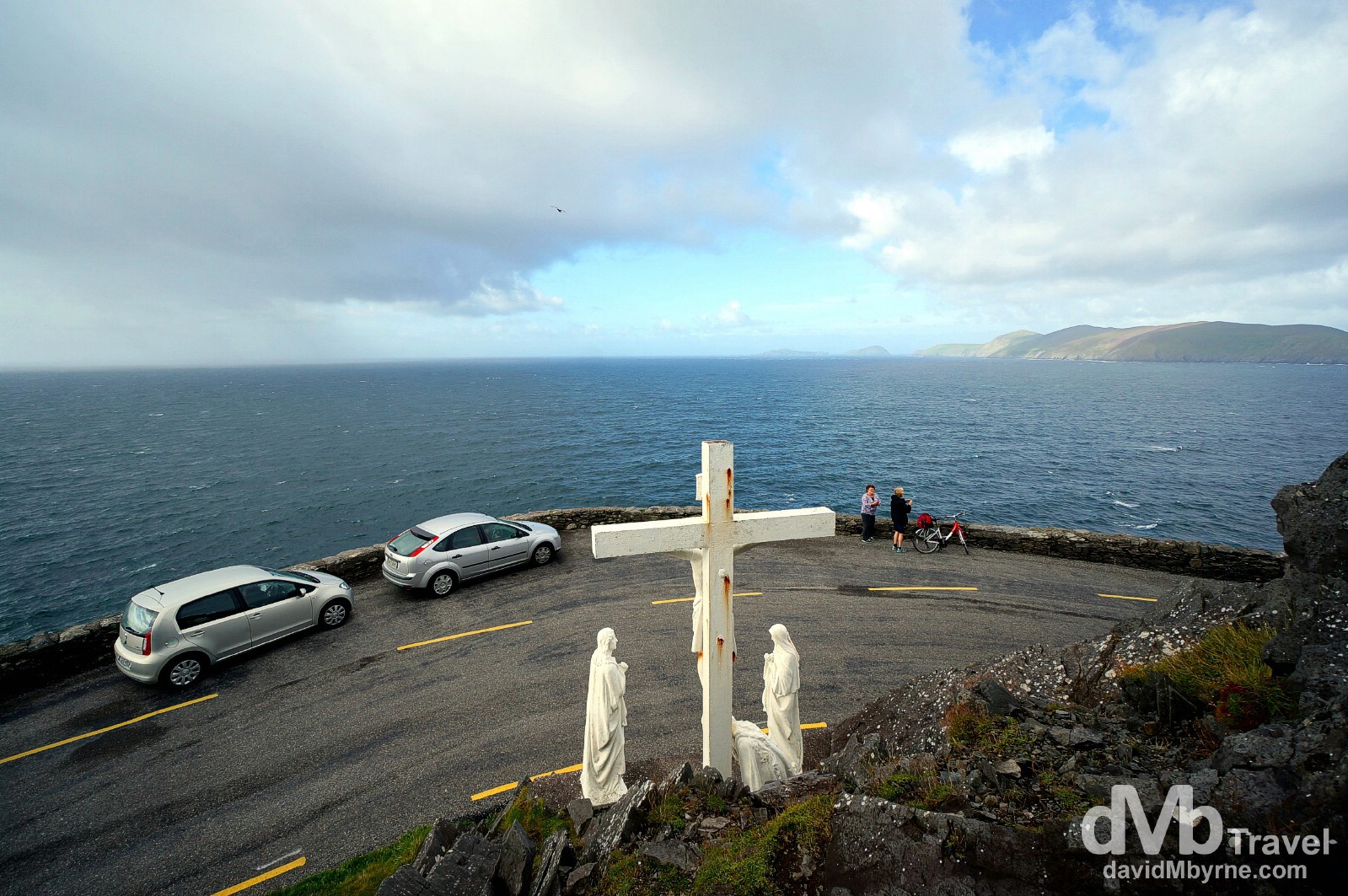
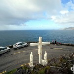
The cross & statues at Slea Head, Dingle Peninsula, Co. Kerry, Ireland. August 28, 2014.
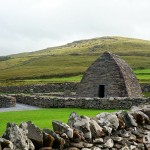
The small Dingle Peninsula offers more than just breathtaking scenery. It is also dotted with numerous prehistoric and early medieval remains, the most famous of which is the Gallarus Oratory.
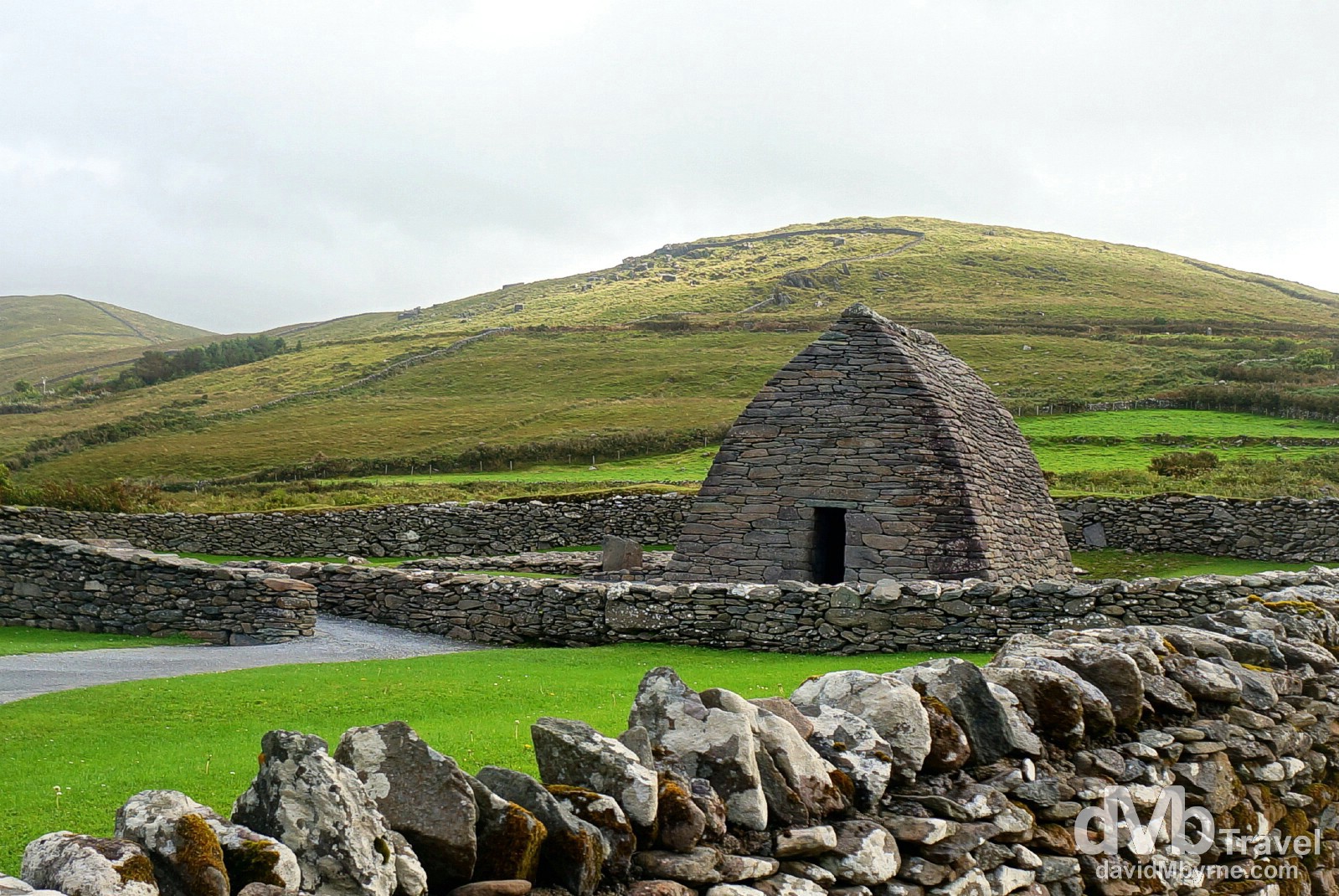
The Gallarus Oratory is a stone building believed to have been built as a church sometime in the 7th or 8th century. It’s a perfect specimen of dry rubble masonry – the large stones are cut on every side and end so as to fit perfectly together, so perfectly that the structure is still waterproof to this day. It’s a remarkable sight. The rectangular building, which measures 8 metres long by 5 metre wide by 5 metres high, was built by early Christians. Successive invaders – Vikings and Normans – burned, robbed and destroyed the settlements around Gallarus but the oratory itself still stands today and is visited by thousands of people each year making it one of the Dingle Peninsula’s most visited attractions. Dingle Peninsula, Co. Kerry, Ireland. August 28, 2014.
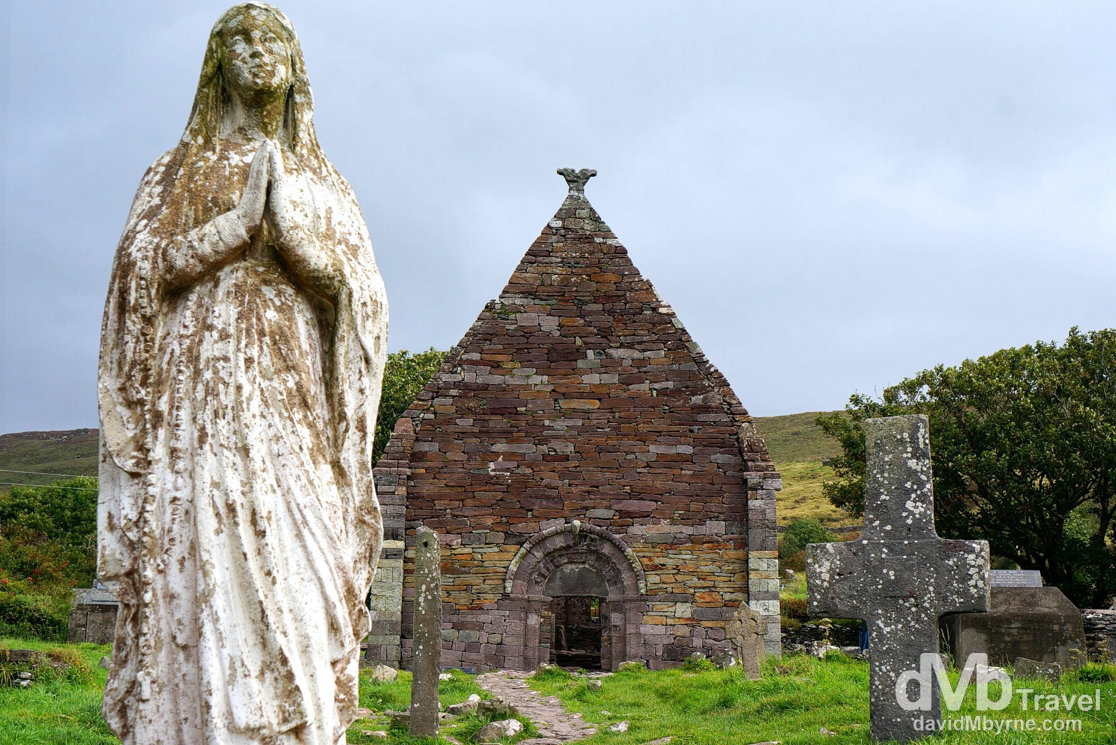
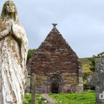
Not far from the Gallarus Oratory is Kilmalkedar Church, one of the most important early churches found on the Dingle Peninsula. It is traditionally associated with St Brendan but it is widely believed to have been founded by St Maolcethair who died in 636. The present structure was built in the middle of the 12th century as a fine example of Irish Romanesque architecture, a style introduced from England and the continent during a time when the Irish church was trying to bring itself into line with the rest of Europe. Inside the church ruins is a 6th century carved stone with the Latin alphabet, the letters DNI (representing DOMINI) still clearly visible, and a small cross. Located in the graveyard surrounding the church is an early sundial, a large stone cross, and an ogham stone, an upright stone carved with predominantly primitive Irish, some 400 of which exist mainly scattered around the Irish Sea and which date to the 5th and 6th centuries. Dingle Peninsula, Co. Kerry, Ireland. August 28, 2014.
The Ring Of Kerry || Peninsula Drive #2
Kerry’s Iveragh Peninsula, south of the smaller Dingle Peninsula, is home of the so-called Ring of Kerry, another (mostly) circular, coast-hugging tourist route. This 180 kilometre drive offers yet more jaw-dropping coastal scenery with pristine beaches, emerald pastures, mountains (including Carrauntoohil, Ireland’s highest), lakes, & picturesque villages. By the time we made if from the Dingle to the Iveragh Peninsula the weather had changed for the worse; the weather is fleeting in this part of the world. Gone were the blue skies but not the scenery, or the surprises. Ruined castle on a beach anyone?
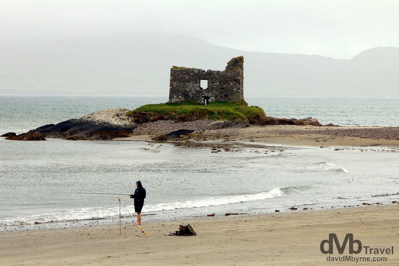
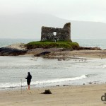
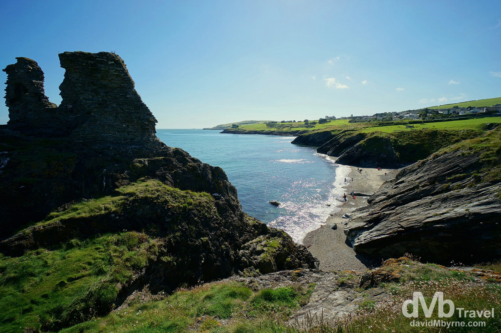
Ballinskelligs (map marker V) is a beautiful Blue Flag beach nestled at the edge of a gorgeous sheltered bay right at the centre of the Kerry Dark-Sky Reserve. This Gaeltacht (Irish speaking) region is accessible off the main Ring of Kerry via the peninsula’s smaller Skellig Ring & it’s here you’ll find McCarthy’s Mor, a.k.a. Ballinskelligs Castle or the famous ‘castle on the beach’. OK, so it’s not much of a castle, or much of a beach for that matter, but you get the point. Ballinskelligs, Co. Kerry, Ireland. August 28, 2014.
– From visitballinskelligs.ie
More Ring of Kerry/Iveragh Peninsula captures.
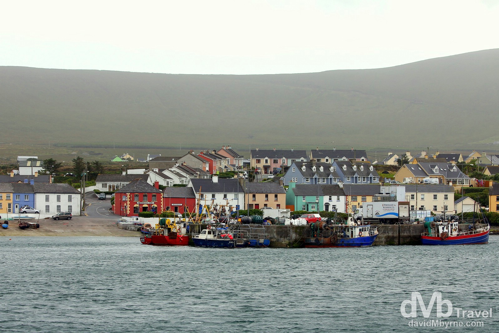
The fishing village of Portmagee (map marker V), access point for boat trips to the nearby UNESCO-listed Skellig Islands, as seen from Valencia Island, Co. Kerry, Ireland. August 29, 2014.
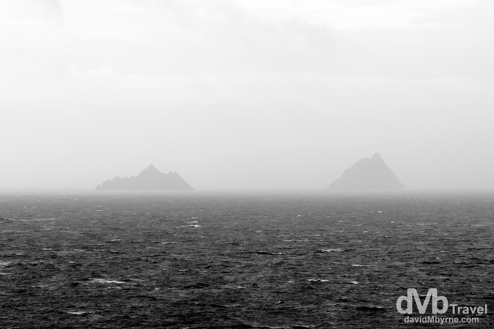
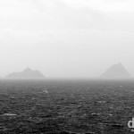
The Skellig Islands (map marker U) as seen from Bray Head car park on Valencia Island. The two small, steep, rocky islands are famous for their sheer isolation & thriving bird colonies (that was before they were thrust into the international limelight by JJ Abrams thanks to their staring role in Star Wars: The Force Awakens). The larger of the two islets, Skellig Michael (a.k.a. Great Skellig, right), is also home to 6th century Christian monastery & is one of only two UNESCO sites in the Republic of Ireland (the other being the aforementioned Newgrange). Although only some 13 kilometres off the tip of the Iveragh Peninsula, views to the islands from the mainland are rare given the inclement weather in this exposed part of the world. Valencia Island, Co. Kerry, Ireland. August 28, 2014.
Cork City || Ireland’s Second City
Cork City (map marker W) is Ireland’s second city (some say its first), a bohemian laid-back city with a great vibe. We didn’t do much in the city yesterday after arriving. We ate, drank & were merry. A bit too merry. As a result today, day 6, was a go-slow day, one mostly spent in the beautiful, laid-back seaport town of Cobh, some 30 kilometres from Cork City.
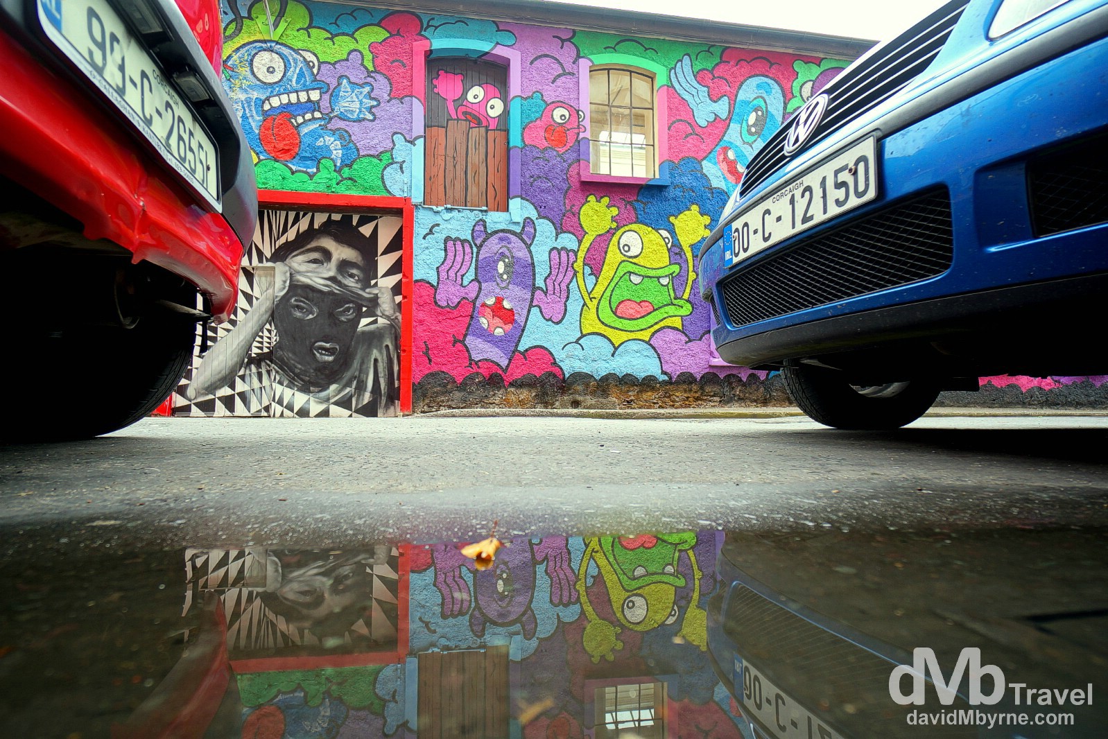
Cork City, Co. Cork, Ireland. August 29, 2014.” width=”1598″ height=”1066″> Street art on Pine Street in Cork City, Co. Cork, Ireland. August 29, 2014.
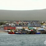
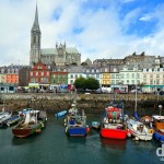
Cobh
Known from 1850 until the late 1920s as Queenstown, Cobh (map marker X) is a tourist & seaport town & home to Ireland’s only cruise terminal. Tourism in the area draws on the maritime and emigration legacy of the town, including its strong association with the ill-fated RMS Titanic; Queenstown was the domed liner’s last port of call & it was from here that, on April 11 1912, she set sail on her maiden voyage, only to sink after hitting an iceberg three days’ later. This piece of maritime history, and with a special focus on the 123 passengers who boarded in Queenstown, the majority of whom perished, is brilliantly documented and brought to life at the Titanic Experience Cobh, somewhere that got €9.50 of our money and a few hours of our time.
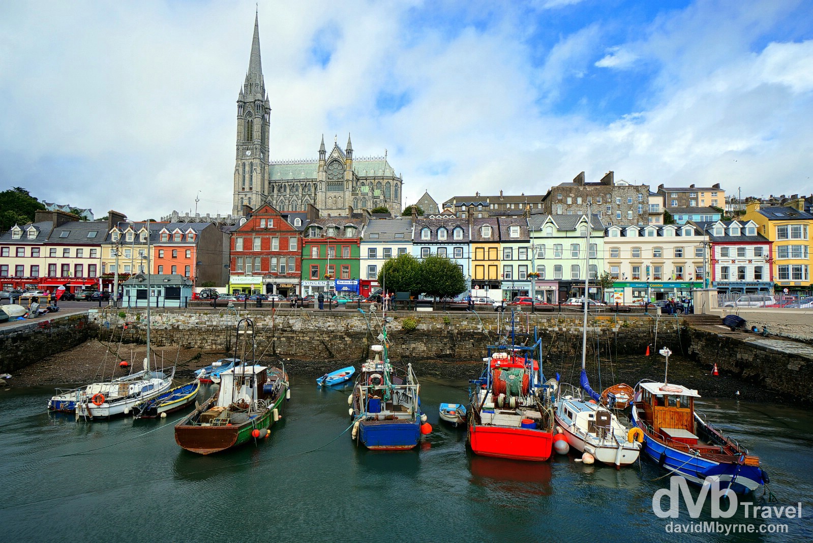
A sheltered section of Cobh Harbour. On the hill in the distance is the town’s landmark, the massive St. Colman’s Cathedral, one of the tallest buildings in Ireland and the first non-ruined church we entered on this road trip. Cobh, Co. Cork, Ireland. August 29, 2014.
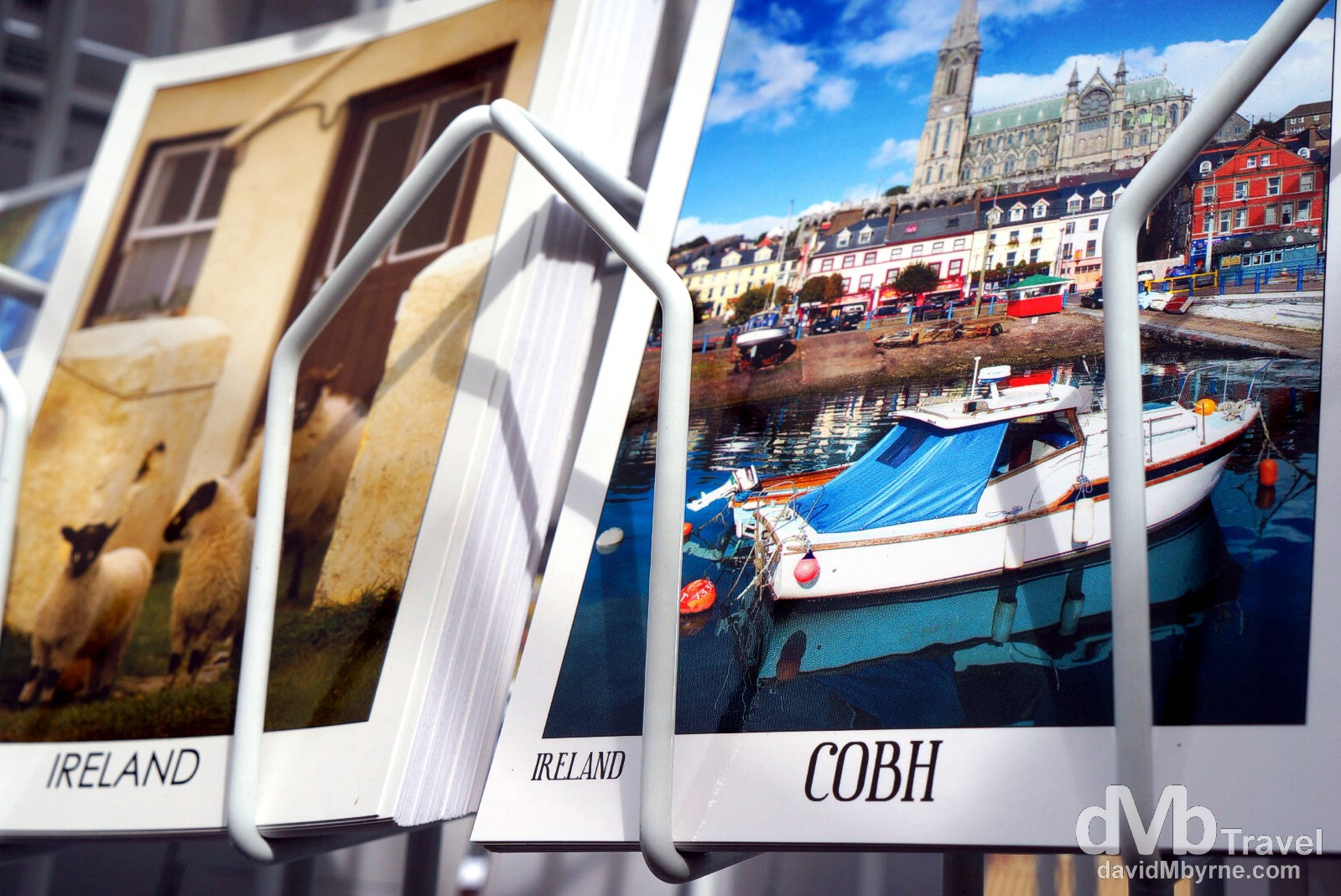
Postcards on sale in Cobh, Co. Cork, Ireland. August 29, 2014.
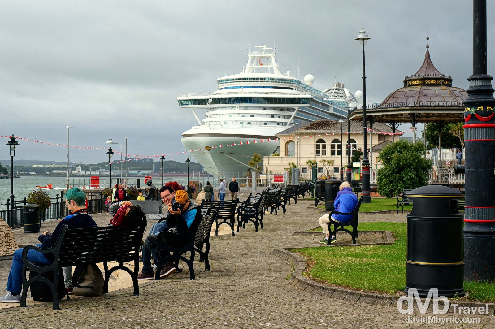
The cruise liner Ruby Princess docked in Cobh. This was the Ruby Princess’ 9th & final visit to Cobh this season, having brought a total of 30,000 passengers to the town. Yes, Cobh is firmly on the tourist trail. Cobh, Co. Cork, Ireland. August 29, 2014.
Ireland Road Trip – Days 7 & 8 Picture of the Day
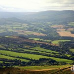
Late afternoon shadows on the landscape as seen from atop the Great Sugar Loaf, Co. Wicklow
Days 7 & 8 || August 30 & 31, 2014
Posting Location: Wicklow Town, Co. Wicklow, Ireland
Oh boy. It has been a busy last 2 days, days 7 & 8 of the ongoing road trip. We’ve clocked quite a few kilometers, the weather has continued to be great & we’ve seen & done a lot. Here’s a quick pictorial recap.
Day 7 Highlights
Whiskey education & tasting (again) at the Jameson Distillery in Midelton, Co. Cork (map marker Z); The Rock of Cashel, Cashel, Co. Tipperary (map marker a); & Kilkenny, Co. Kilkenny (map marker b).
Jameson Distillery || The Home of Irish Whiskey
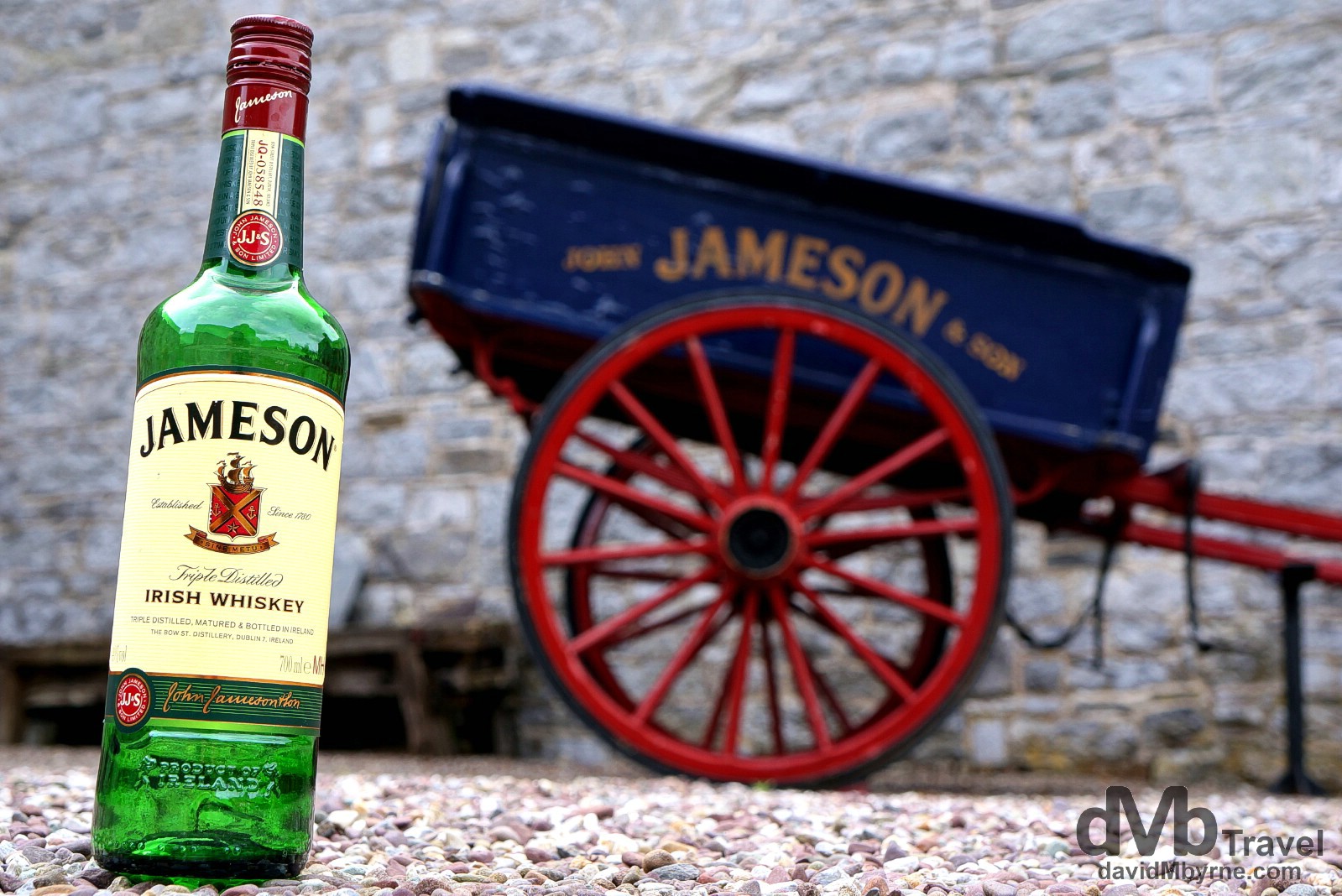
Jameson Distillery, Midleton, Co. Cork. Having visited the Bushmills Distillery in Northern Ireland on day 2 of the road trip, we (Ian) were (was) keen to visit the largest of the Republic’s whiskey distilleries. Home of the world famous Jameson Whiskey, Ireland’s largest selling whiskey, the tour is a polished affair with the usual explanations & demonstrations of all things whiskey. Midleton, Co. Cork, Ireland. August 30, 2014.
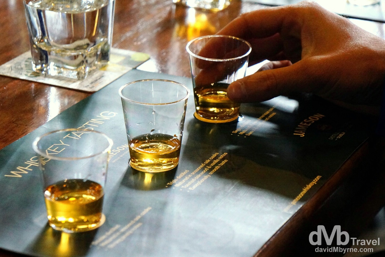
Ian doing the end-of-tour Irish Vs Scottish Vs American whiskey tasting test at the Jameson Distillery in Midleton, Co. Cork, Ireland. August 30, 2014.
Rock of Cashel, Co. Tipperary
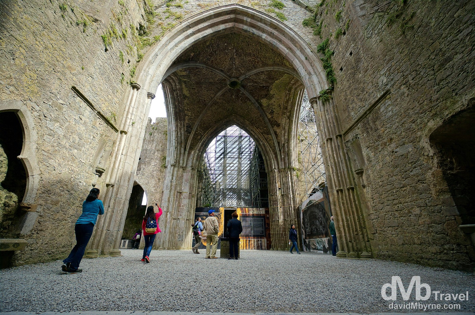
Inside the 13th century Gothic Cathedral of the Rock of Cashel, Cashel, Co. Tipperary. I’d never been before so en route to the east coast we stopped off at the Rock of Cashel, a spectacular group of Medieval buildings set on an outcrop of limestone in the Co. Tipperary town of Cashel. The buildings of note are a 12th century round tower, the oldest of the site’s structures; the Romanesque Cormac’s Chapel, begun in 1127 and consecrated in 1134; a 15th century Castle; & this, the 13th century Gothic cathedral. The majority of the roof in here is long gone but the massive almost hollow shell of the the present-day cathedral makes for great wide-angle territory. Rock of Cashel, Cashel, Co. Tipperary, Ireland. August 30, 2014.
Kilkenny || The Marble City
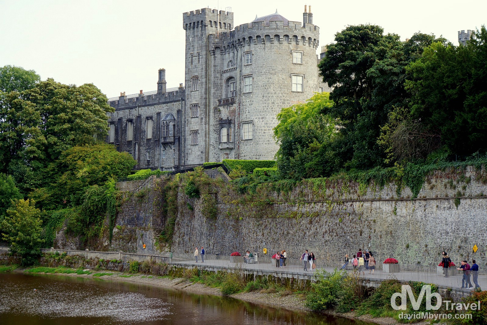
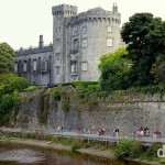
Kilkenny, a.k.a. The Marble City, is one of Ireland’s most likable cities & one that houses a lot of historic buildings. This is a picture of Kilkenny Castle as seen from a bridge over the River Nore. One of Ireland’s best preserved castles, it was built between 1195 & 1213 and was a symbol of Norman occupation of Ireland. The property was transferred to the people of Kilkenny in 1967 for £50 and the castle and grounds are now managed by the the Irish Government’s Office of Public Works. Kilkenny, Co. Kilkenny, Ireland. August 30, 2014.
Day 8 || Wicklow
Wicklow, a.k.a. The Garden of Ireland, my home country, got us for the whole day. The weather was glorious. In fact the whole day was: we sunned ourselves in Wicklow Harbour (map marker c); we stared up at Ireland’s most famous Round Tower at the Early Medieval monastic settlement of Glendalough (map marker d); we smelled the heather on the Sally Gap, one of two mountain passes through the Wicklow Mountains, the largest continuous upland area in Ireland; we strolled around the gardens in Powerscourt Estate (map marker e), recently rated as the third best gardens in the world by National Geographic; we had lunch (& a beer) by the Victorian Promenade in Bray, Wicklow’s largest town; & finally we took in the views over the county & southern Dublin from atop the county’s iconic Sugar Loaf (map marker f).
Wicklow Town || Home
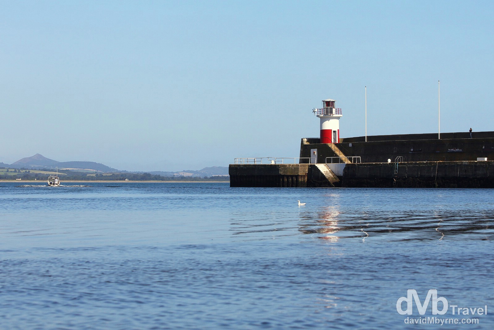
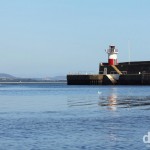
We started today down in Wicklow harbour. Rarely have I been such a tourist in my hometown but rarely had I seen it looking as well either, bathed as it was in glorious sunlight. This is a picture of the harbour’s East Breakwater/pier. Built in the early 1880s, it is one of two piers that protect the entrance to Wicklow harbour port, the North Groyne having been built in the early years of the 20th century. The lighthouse seen here, built on a cantilevered concrete walkway that runs the length of the breakwater, dates to 1886. Finally, in the far distance can be seen the Great Sugar Loaf, the pimple-like hill that is a prominent Co. Wicklow landmark & one we scaled earlier today (see later pictures). Wicklow Harbour, Co. Wicklow, Ireland. August 31, 2014.
East coast scenery as seen from the ruins of the Black Castle overlooking Wicklow harbour. Built on a rocky promontory overlooking the sea, the castle was built on the site of an earlier Viking fort (circa. 834). It was constructed in the late 1170s by the Norman family the Fitzgeralds following a Norman invasion. The keep of the castle was originally 4-storey structure and was entered by crossing a drawbridge. During the next 5 centuries the castle was periodically under attack and was finally destroyed by fire in the 1640s. It has stood as a ruin ever since. Wicklow Town, Co. Wicklow, Ireland. August 31, 2014.
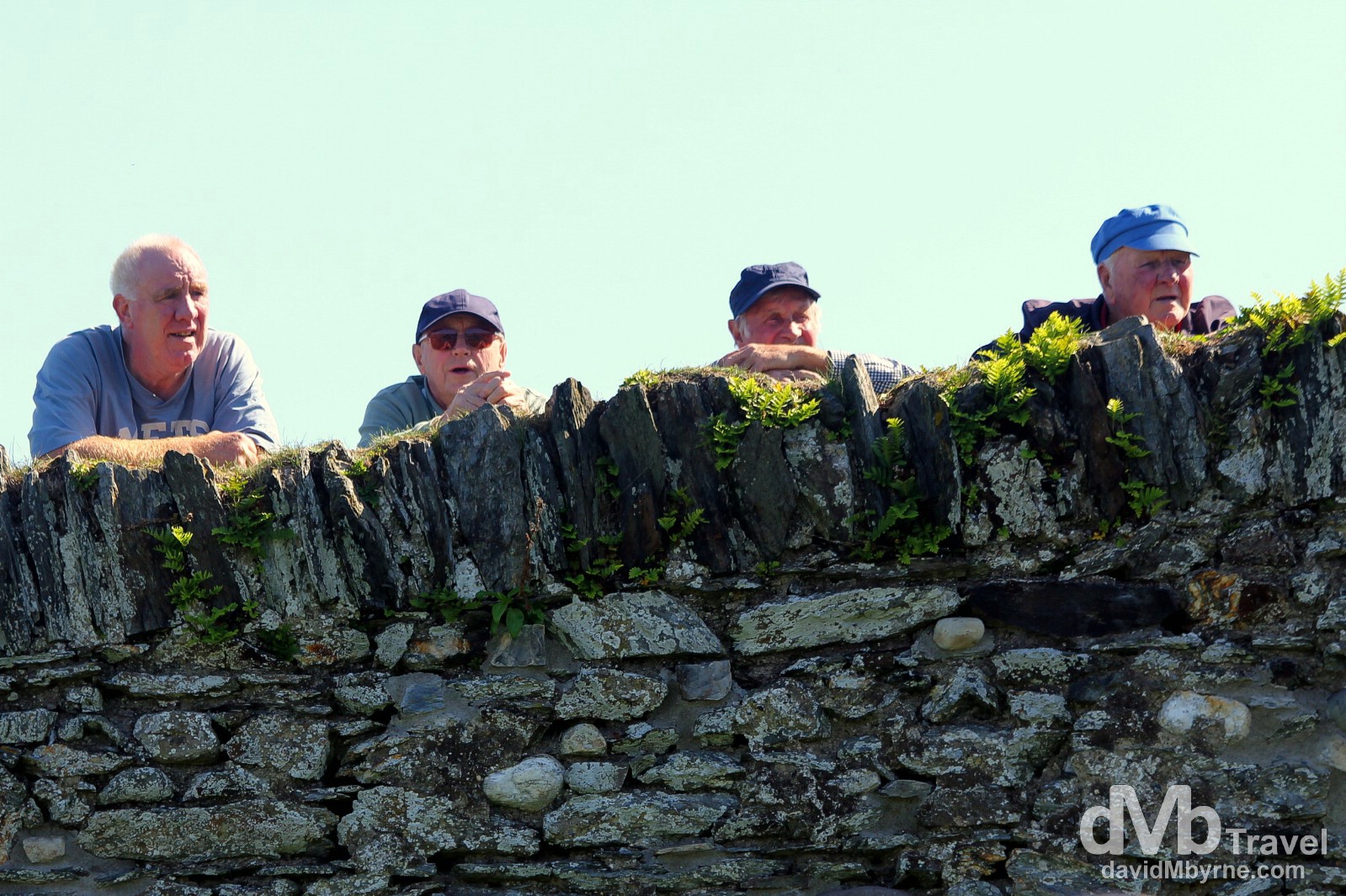
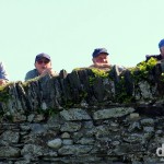
Locals overlooking the harbour in Wicklow Town, Co. Wicklow, Ireland. August 31, 2014.
– Sigmund Freud commenting on the Irish
Glendalough || Ireland’s Most Famous Early Medieval Monastic Settlement
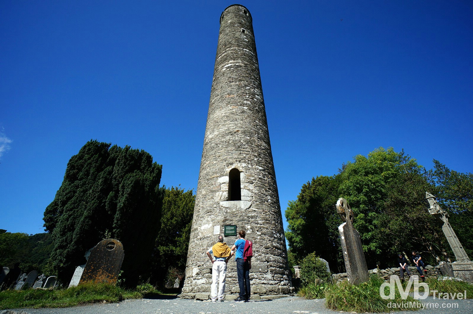
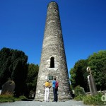
Admiring the Round Tower in Glendalough, Co. Wicklow. Glendalough, meaning ‘Glen of two Lakes’, is a glacial valley renowned for the Early Medieval monastic settlement that was founded here in the 6th century by Saint Kevin, a hermit priest. Remnants of the settlement still stand today making this, given its proximity to Dublin, one of Ireland’s most visited sites. The site’s tower, built of mica-slate interspersed with granite sometime betweem 900 and 1200, is over 33 metres high with an entrance almost 4 metres from the base. Round towers, landmarks for approaching visitors, were built primarily as bell towers of Early Irish Monasteries, summoning monks to prayer, but it is speculated that they also served on occasion as store-houses and as places of refuge in times of attack. Glendalough, Co. Wicklow, Ireland. August 31, 2014.
Sally Gap || Wicklow Mountains
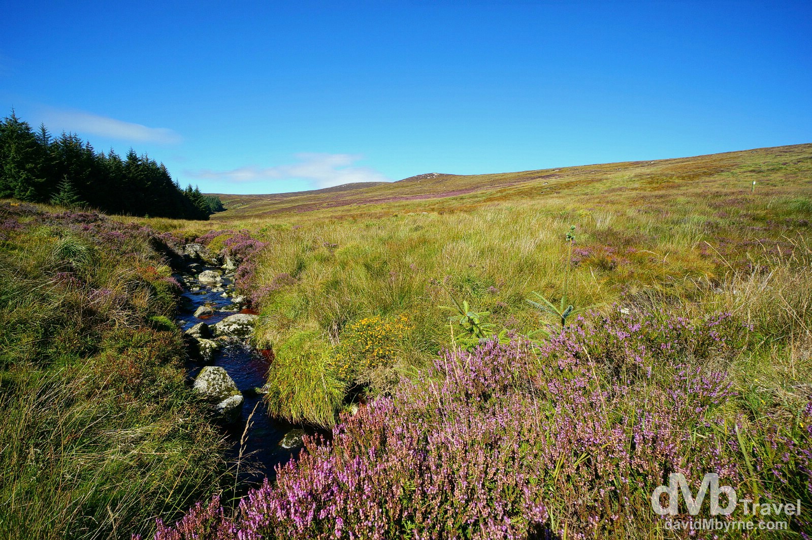
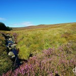
Summer flora on the Sally Gap, Co. Wicklow, one of two east to west routes through the Wicklow Mountains, Ireland’s largest continuous upland area occupying the whole centre of Co. Wicklow. The Sally Gap road passes through some spectacular scenery and is an especially scenic this time of year – in winter the road is often impassible due to snow & ice. The Sally Gap of the Wicklow Mountains, Co. Wicklow, Ireland. August 31, 2014.
Powerscourt Estate
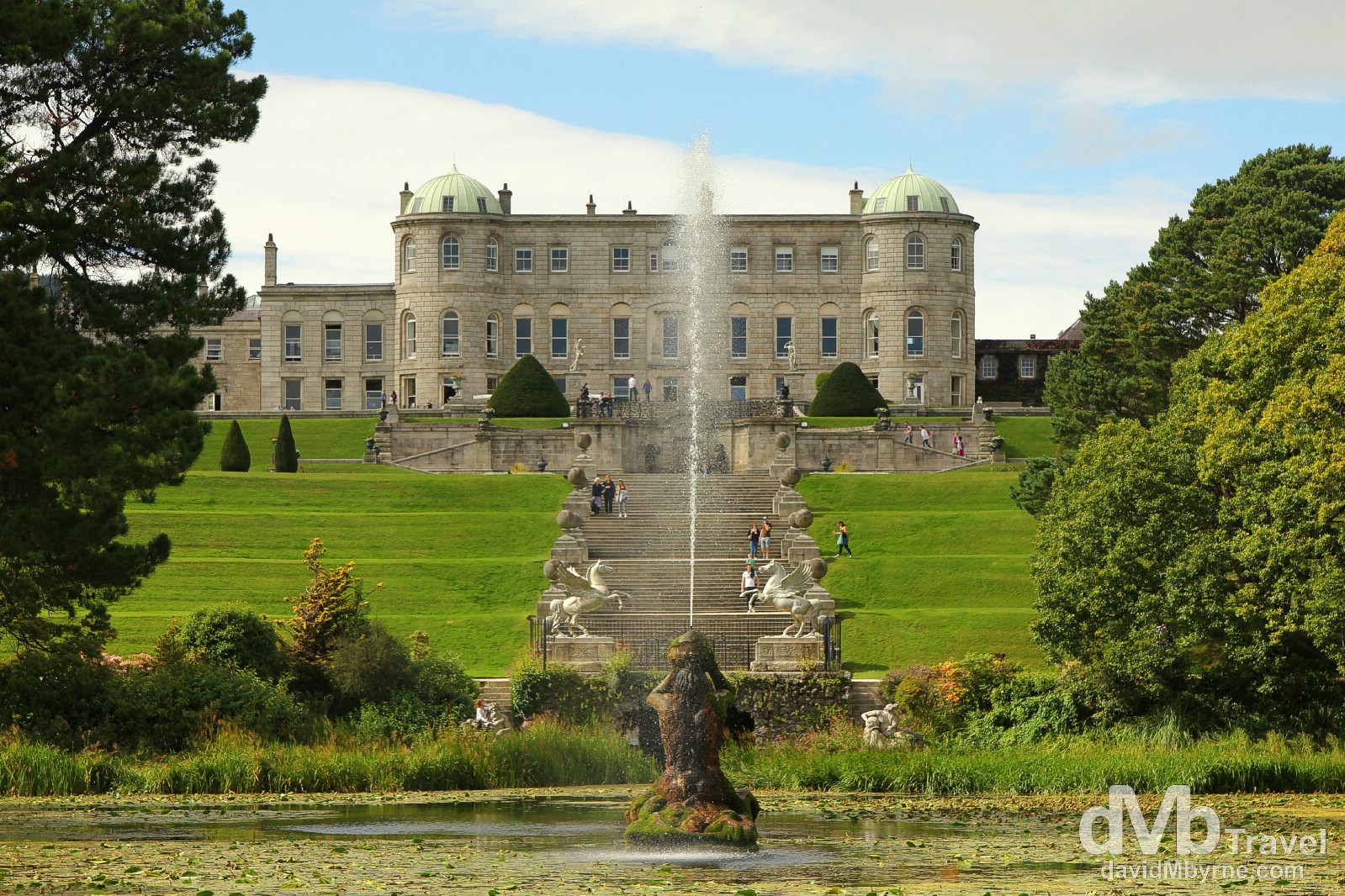
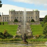
In the grounds of Powerscourt Estate, Enniskerry, Co. Wicklow, the gardens of which were recently voted by National Geographic as the third best gardens in the world after the gardens of Château de Versailles in France & the Royal Botanic Gardens at Kew in Surrey, England. The house was originally a 13th century castle but was extensively altered in the 18th century to its present form. It burnt to the ground in 1974 & wasn’t renovated until 1996. Today the 19 hectares (47 acre) estate & its gardens, which took 20 years to complete in 1880, are a massive tourist attraction and somewhere I had never visited even though it’s only a short drive from my house. Powerscourt Estate, Enniskerry, Co. Wicklow, Ireland. August 31, 2014.
The Great Sugar Loaf
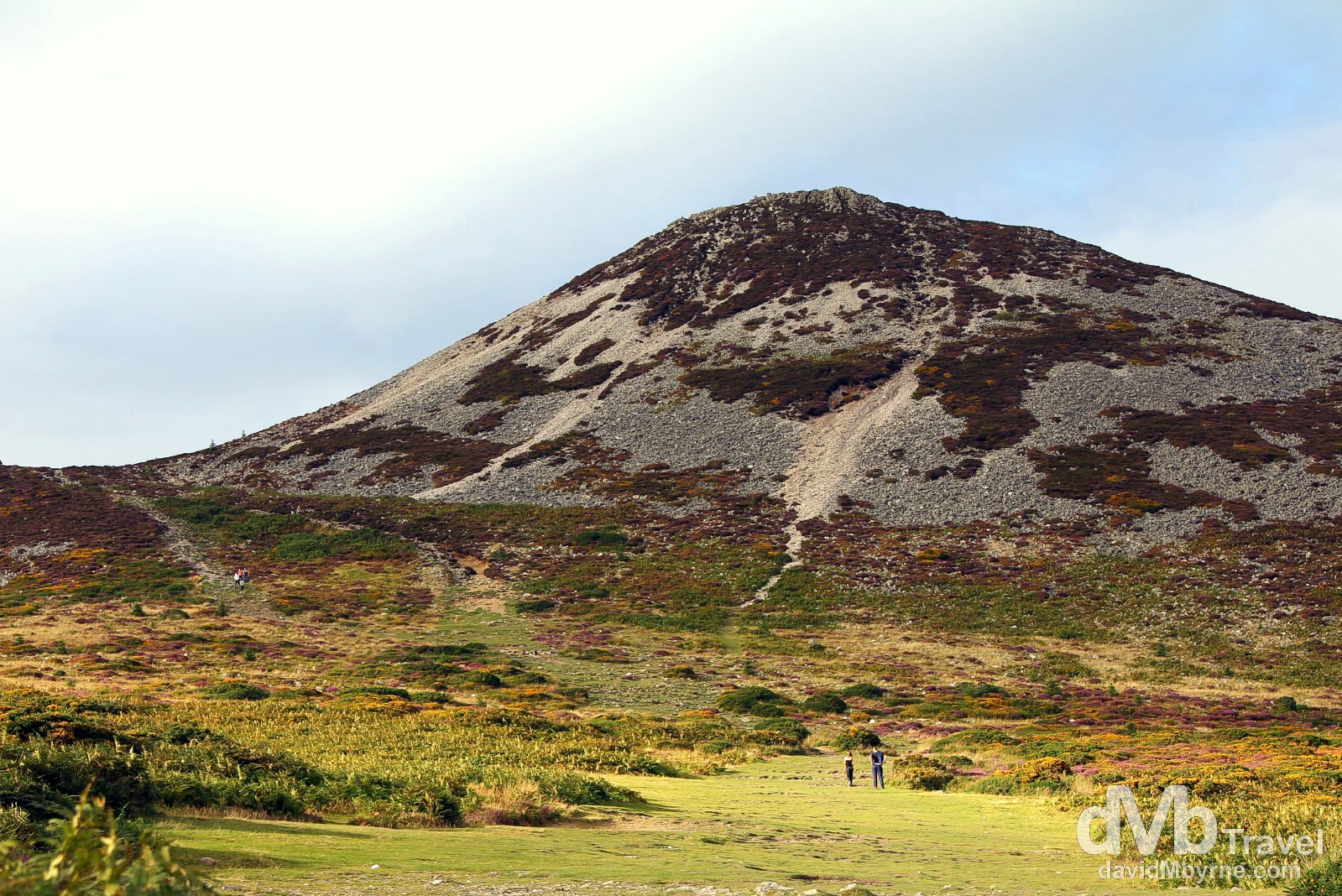
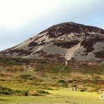
It had been at least 25 years since I last scaled the Great Sugar Loaf, a prominent Co. Wicklow landmark. Although only 501 metres (1,644 ft) high, its isolation from other hills, steep slopes and volcanic appearance makes it appear much taller than it actually is. The Great Sugar Loaf in Co. Wicklow, Ireland. August 31, 2014.
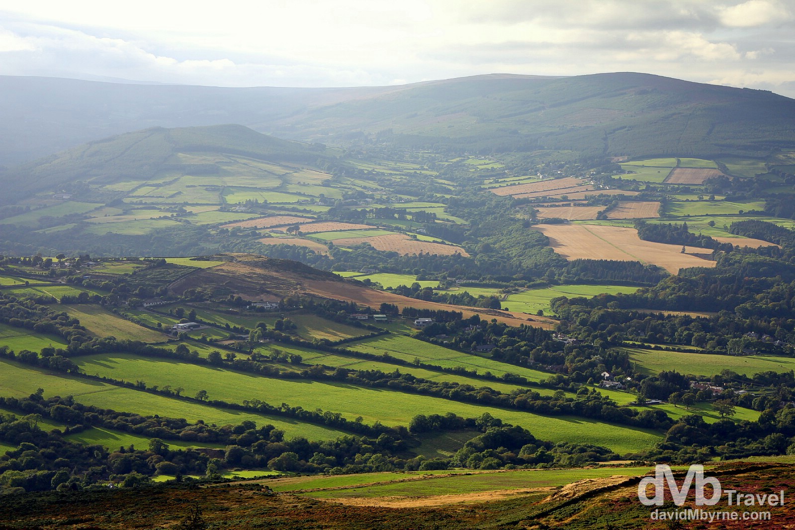
The Wicklow countryside as seen from atop the Great Sugar Loaf which affords great views of the surrounding landscape. Co. Wicklow, Ireland. August 31, 2014.
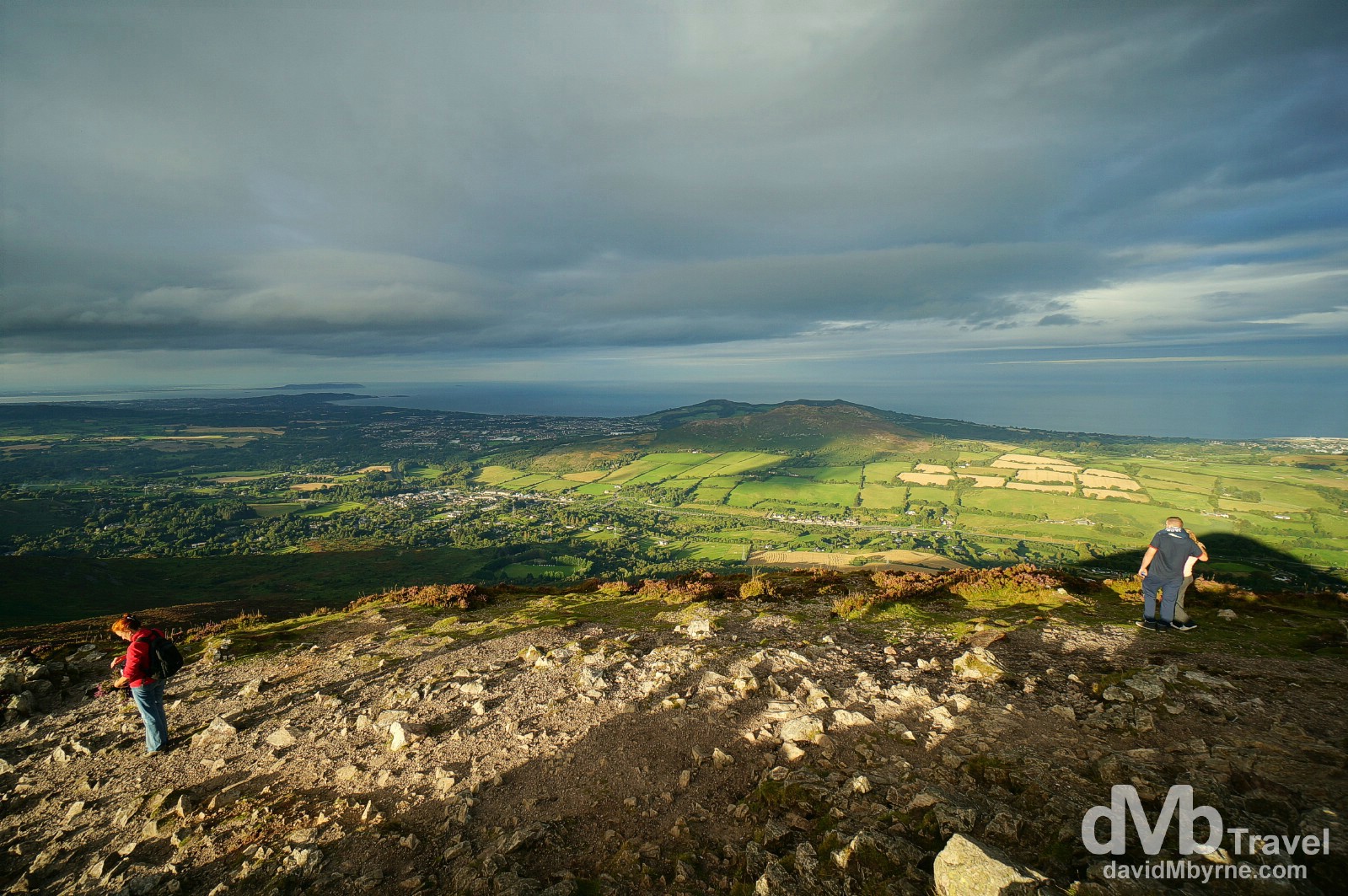
It was late in the evening when we completed the 25-minute climb to the summit of the Great Sugar Loaf. The sun was spotty and that coupled with the views towards southern Dublin & the waters of the Irish Sea made for a wonderful scene, just the latest of this road trip. Atop the Great Sugar Loaf, Co. Wicklow, Ireland. August 31, 2014.
One Stop Remaining
Tomorrow, day 9, we make it to the capital, Dublin. It’s the last day of this little adventure of ours. We’ve been blessed thus far with most aspects of the trip so here’s hoping the weather holds out for one more day.
Ireland Road Trip – Day 9 Picture of the Day
The city of Dublin as seen from the Gravity Bar of the Guinness Storehouse
Day 9 || September 1, 2014
Posting Location: Wicklow Town, Co. Wicklow, Ireland
It was my birthday today. It was also day 9 of chaperoning Ian of BorderlessTravels.com around Ireland. We’ve come full circle and today marked our last real day of being tourists. We spent it in the capital of Dublin (map marker g). I’ve always liked my capital. Tourists seem to like it too – it’s always busy but every time I pay a visit to the city it seems to be getting more touristy (& there’s certainly enough tourist tat on offer to appease all). Here are a few pictures I captured today.
Georgian Dublin
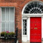
Dublin is a very Georgian city and Georgian architecture is prominent, especially on the city’s south side like here on Leeson Street Lower. Dublin, Ireland. September 1, 2014.
Moore Street
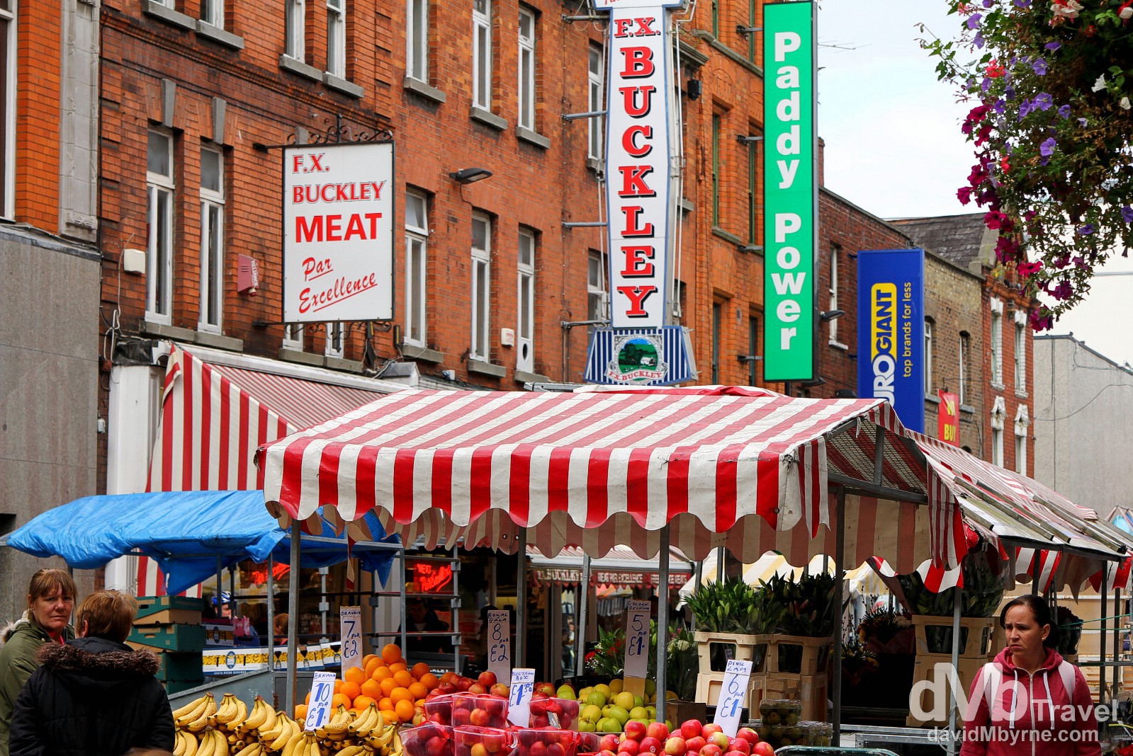
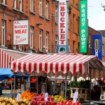
Moore Street, Dublin. The famous Moore Street open-air fruit and vegetable market is Dublin’s oldest food market. Bustling in years gone by, today it’s a quieter, tamer version of its former self. That said, the market stalls & the witty and friendly Dubliners who man them are still Dublin institutions and one of the well-known attractions on the city’s north side. Moore Street, Dublin City, Co. Dublin, Ireland. September 1, 2014.
The Ha’penny Bridge & River Liffey
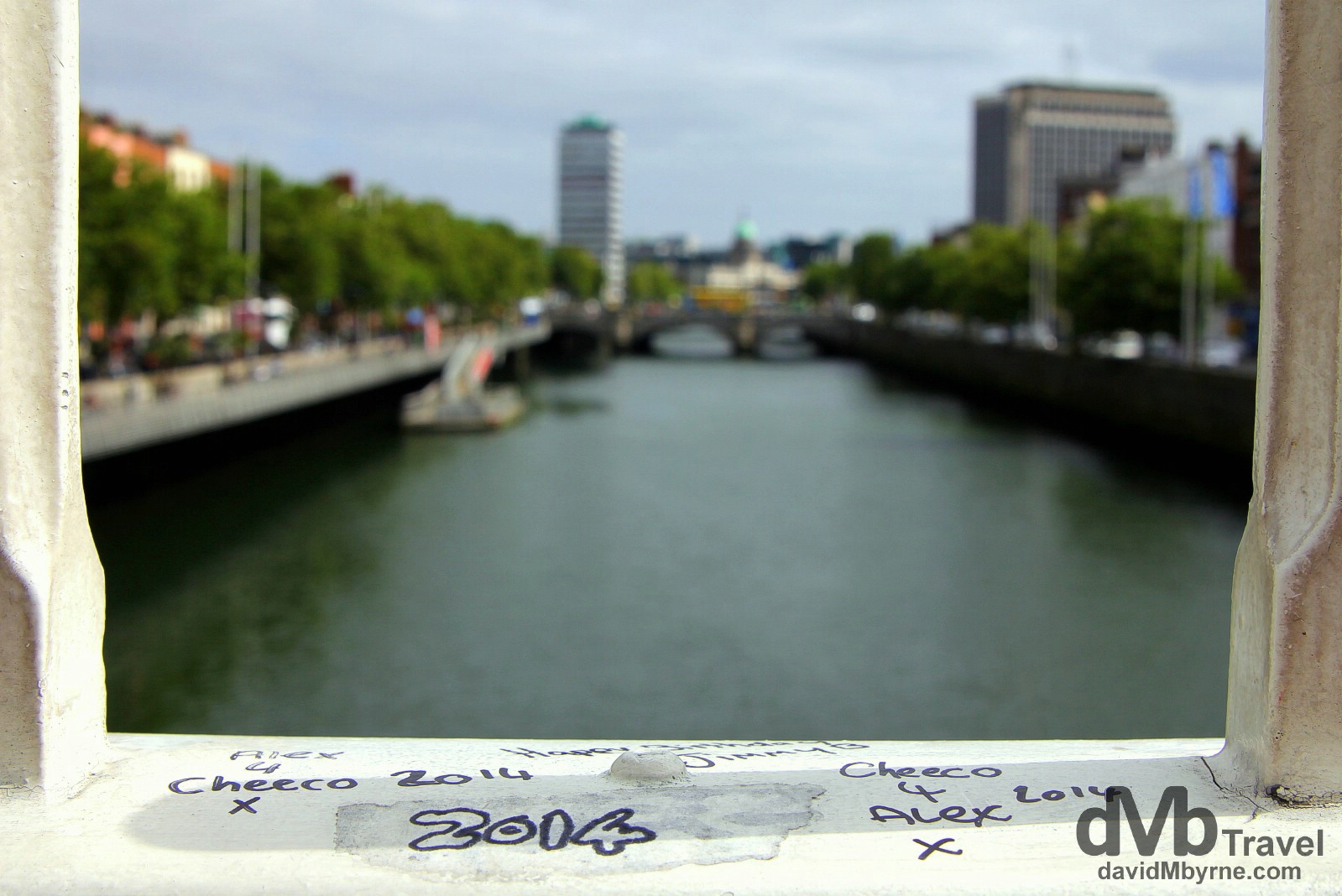
Graffiti on the Ha’penny Bridge spanning the River Liffey. The Ha’penny Bridge, officially the Liffey Bridge, is a pedestrian bridge linking the north & south sides of the city. Built in 1816 of cast iron, the 43-metre long structure is an iconic Dublin sight and derives its name from the toll payable to cross when it first opened in 1816 – prior to this ferry was the only way to cross the river. In the distance is the slender tower of Liberty Hall, a 16-storey, 59 metre Dublin landmark that was once the tallest building in the city (it’s now third tallest). Dublin, Ireland. September 1, 2014.
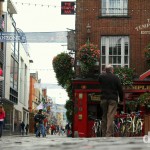
Temple Bar
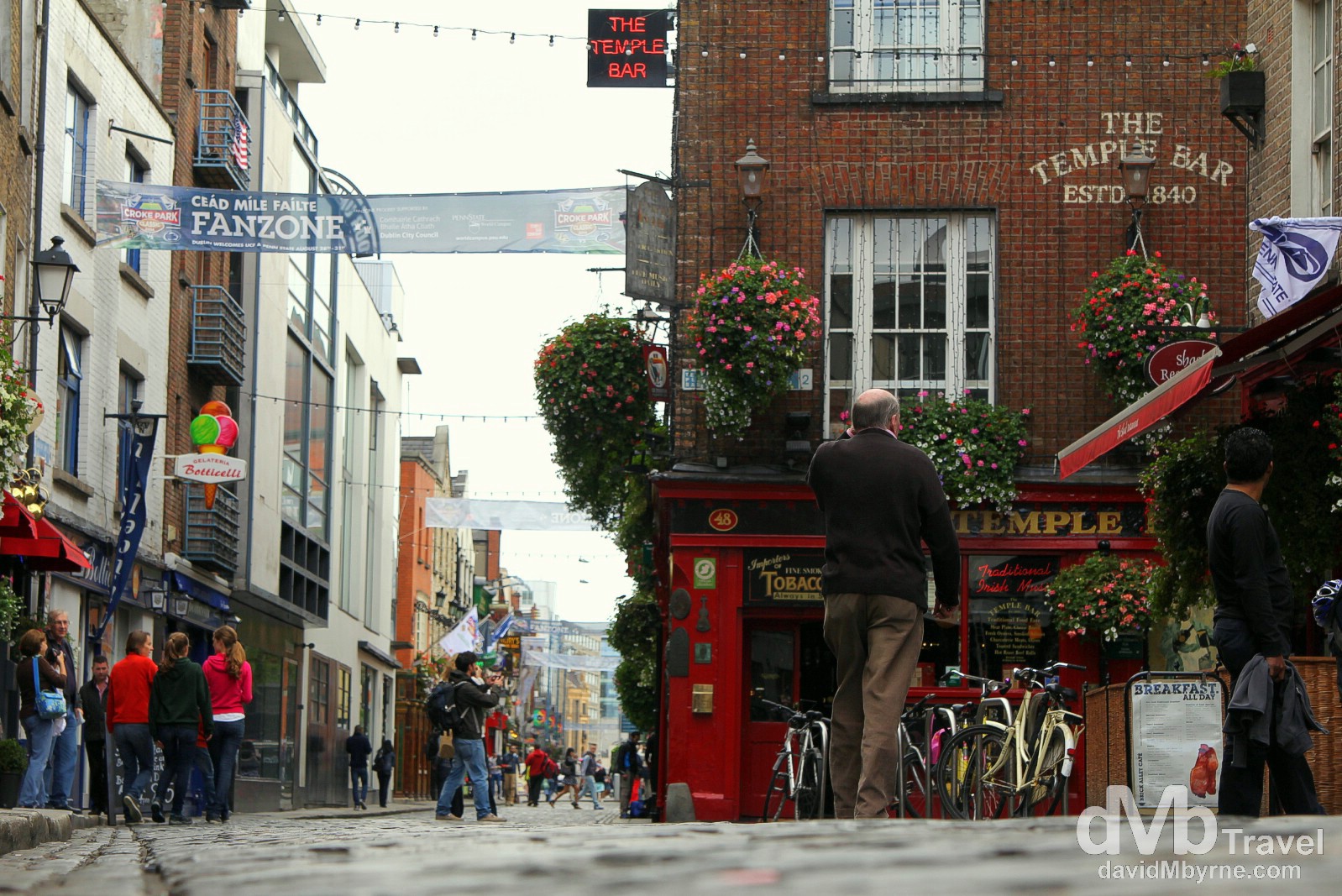
Temple Bar, Dublin’s cultural quarter & night time entertainment district. Some (mostly tourists) love it, some (mostly locals) hate it. The district is named after Sir William Temple (1555-1627), one of the district’s first residents, a renowned teacher & philosopher who built his house and gardens here on newly reclaimed land. Today Temple Bar is a grid of narrow, 18th century cobbled lanes full of bars, restaurants & souvenir shops. It’s a lively place that’s either to be avoided or embraced, depending on your outlook. Temple Bar, Dublin, Ireland. September 1, 2014.
Guinness Storehouse || The Home of Guinness
From Temple Bar to the Guinness Storehouse, Ireland’s most popular paid tourist attraction.
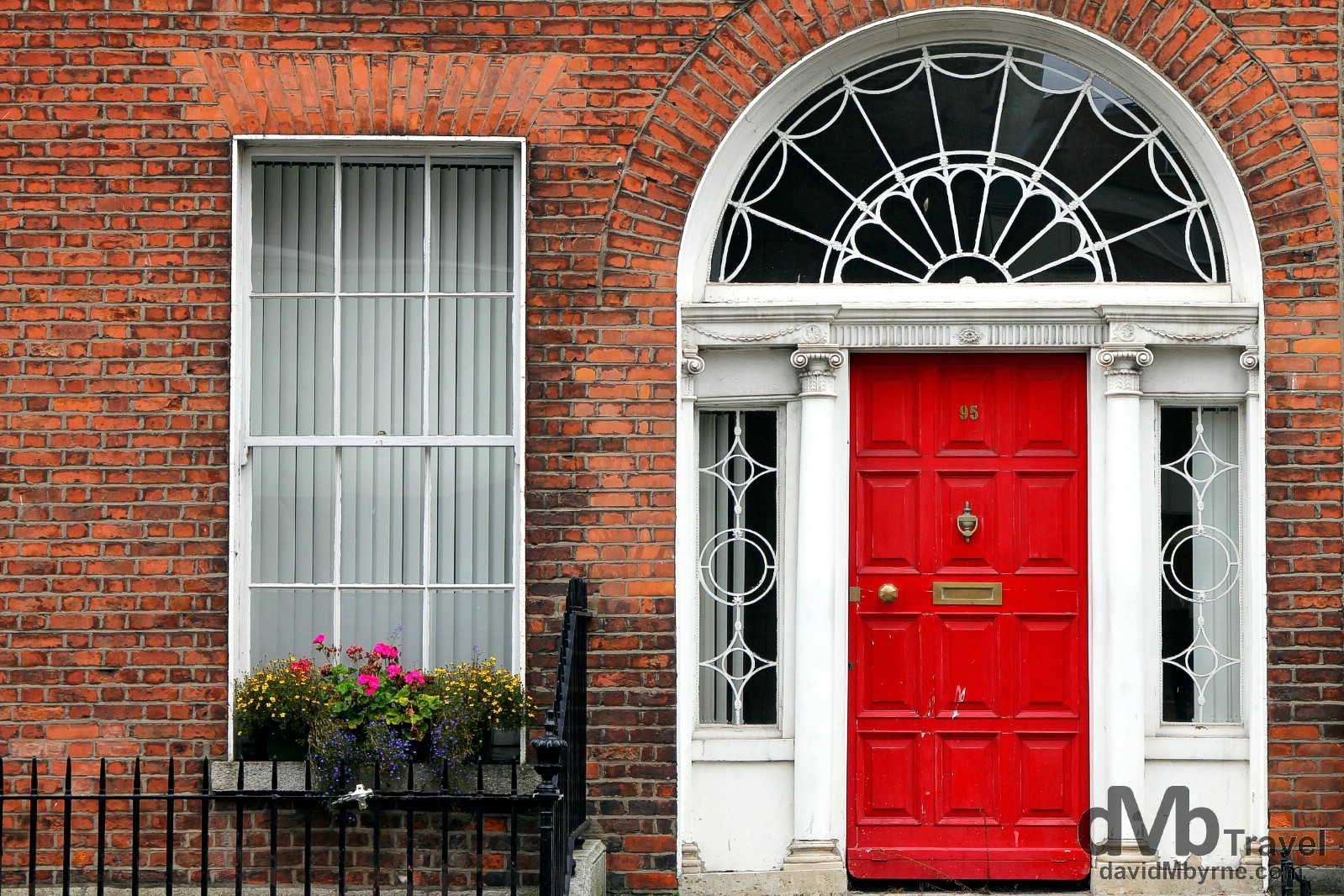
St. Jame’s Gate, the home of Guinness & of the Guinness Storehouse (map marker g). The Storehouse is a museum to Ireland’s most famous export & its most famous tipple. It is housed in an historical building, a former Fermentation Plant where Guinness was first brewed back in 1759 – it was then that Arthur Guinness signed a 9,000-year lease on the site. Today the 7 floors of the Guinness Storehouse experience – housed inside the world’s biggest pint glass, one that if full could hold 14.3 million pints – tells the story of the iconic brew, right from its origins to its growth into a global brand, one known & enjoyed the world over. It’s very touristy, very commercial, and at €18 a pop it’s not particularly cheap. But it is a must-do if only to make it to the top floor Gravity Bar to sample a Guinness while taking in the unobstructed, 360-degree panoramic views of Dublin. St. Jame’s Gate, Dublin, Ireland. September 1, 2014.
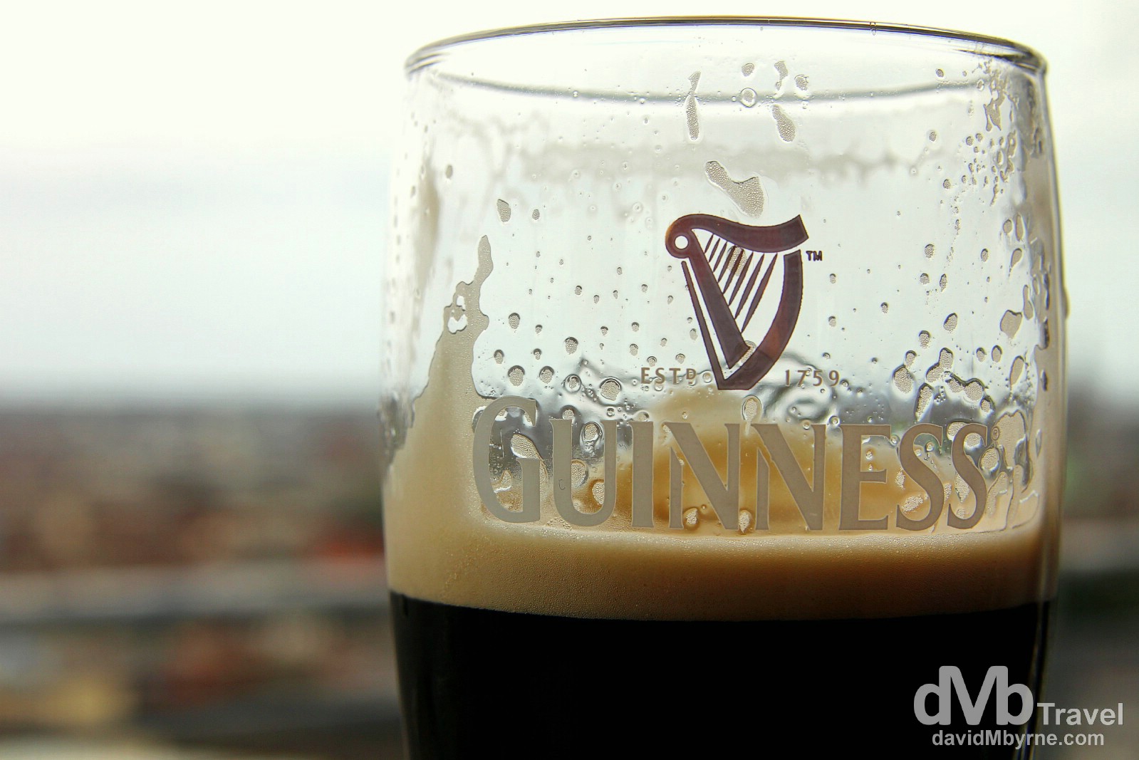
A visit to the Guinness Storehouse ends at the top floor Gravity Bar where, it is said, you have truly reached the top of the world. From there you can experience great views over Dublin while enjoying a complimentary pint of The Black Stuff, one that hasn’t travelled too far, meaning that you’re quite likely to agree that it tastes better here than anywhere else in the world. St. Jame’s Gate, Dublin, Ireland. September 1, 2014.
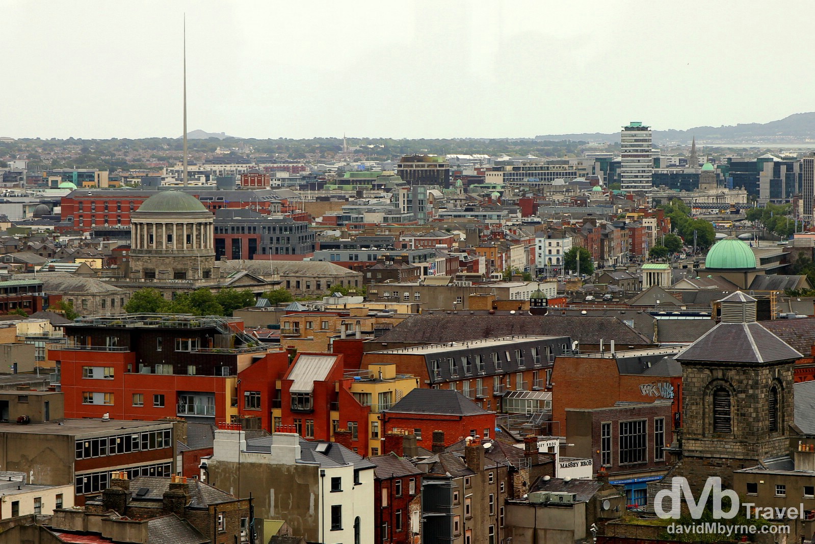
A section of central Dublin as seen from the 7th floor Gravity Bar in the Guinness Storehouse. The aforementioned Liberty Hall can be seen to the right of the image and the Spire of Dublin to the left. The 121 metre, pin-like, stainless steel Spire is the tallest structure in the city. It was commissioned as part of the Millennium project for Dublin but wasn’t completed until early 2003. Dublin, Ireland. September 1, 2014.
Today was a good day. Ian enjoyed it. That said, it’s safe to say that Dublin wasn’t a highlight of his time in Ireland. It’s a city, albeit a nice one, & this Canadian is a self-confessed nature fan. So suffice to say the capital wasn’t likely to hit a chord having spent 8 days driving around (mostly) rural Ireland. “People made Guinness, God made the Cliffs of Moher“, he stated today while we were en route to the Guinness Storehouse. I kind of liked that.
Day 10 || September 2, 2014
Posting Location: Wicklow Town, Co. Wicklow, Ireland
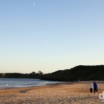
Ian goes home tomorrow. We didn’t do much today, didn’t drive very far. We played a round of golf (scores best left undocumented), did some work online & paid a visit out the road to Britts Bay (map marker h), Wicklow’s very own Costa del Sol (not really).
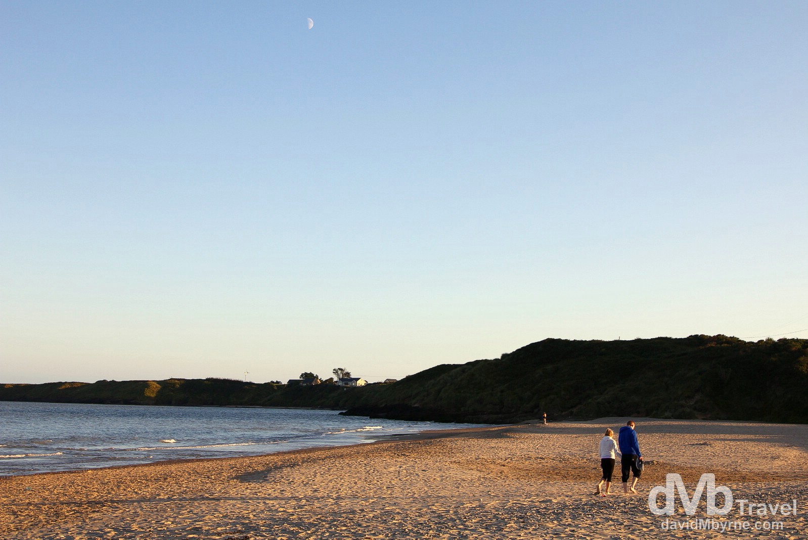
An evening stroll (& long shadows) on the beach at Brittas Bay, a 4 kilometre stretch of sand on the Irish Sea coast. Flanked by extensive sand dunes, the beach is one of Ireland’s best stretches of sand – it regularly wins EU Blue Flag status, the emblem for the highest quality beaches. The beach is the centrepiece of the Brittas area, a popular holiday & holiday home destination since the 1950s – it’s especially popular in summer with locals & day trippers from Dublin. Brittas Bay, Co. Wicklow, Ireland. September 2, 2014.