Scotland
Pictorial Highlights Of A 10-Day Road Trip Around The Scottish Highlands & Lowlands
Urquhart Castle on the shores of Loch Ness, Highland, Scotland. September 16, 2014
– Robert Burns, Scottish Poet (1759-1796)
![]()
A road trip around Scotland is always going to be enjoyable & memorable travel experience. For course it is. But for anyone who travels with photography in mind, Scotland is an especially special treat. It was for me. The country lived up to the high expectations I had for it. Aye, it was photogenic. It was historic & futuristic, old & new. It was inviting. It was witty. It also threw up a few pleasant surprises, especially with regard to the weather. What follows is a day-by-day pictorial look at my time exploring Scotland – 51 pictures recapping 10 days spent driving 1,468 miles/2,362 kilometres around one of the world’s most beautiful countries.

The ruins of Urquhart Castle on the shores of Loch Ness, Highland, Scotland. September 16, 2014.
Interactive Road Trip Map & Selected Daily Highlights
Daily Highlights
Days 1 & 2
Glasgow (map A)
Day 3
Stirling (map B) & Edinburgh (map C)
Day 4
Cairngorms National Park, Highland (map E)
Day 5
Dunnet Head, Highland (map I)
Day 6
Loch Eriboll, Highland (map L)
Day 7
Loch Oich, Highland (map Q)
Day 8
Isle of Skye, Inner Hebrides (map R-X)
Day 9
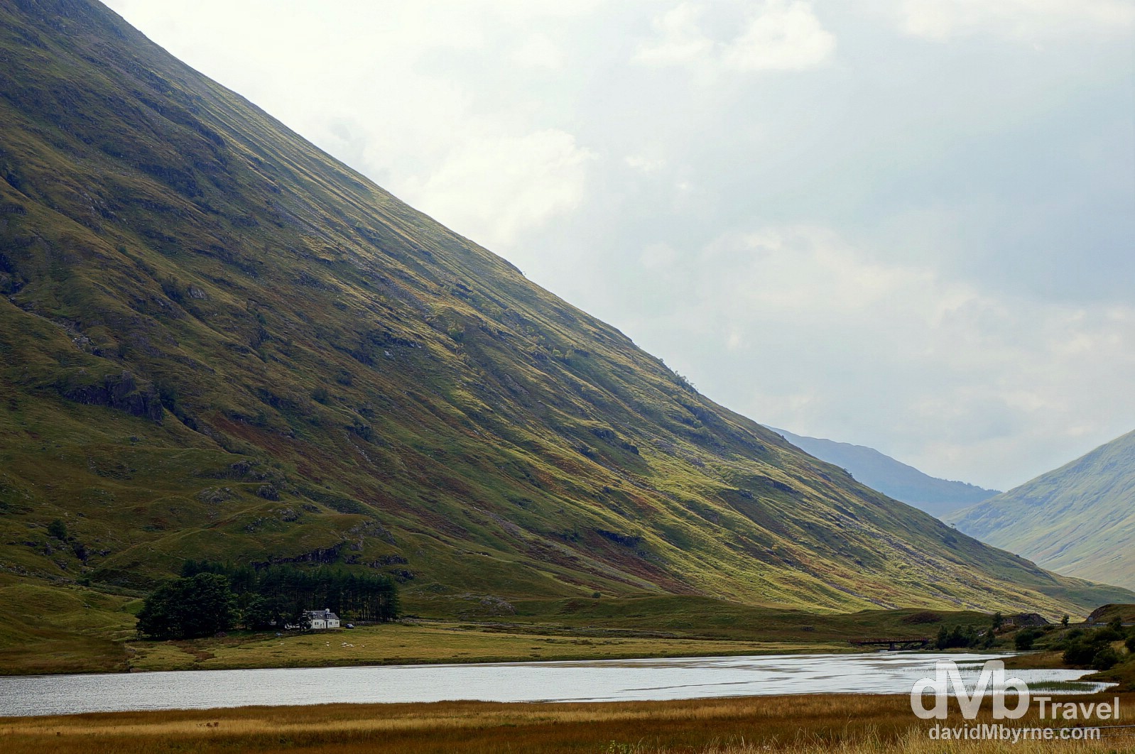
Glen Coe, Highland (map a)
Day 10
Culzean Castle, Ayrshire (map d)
Pre-Departure – September 9, 2014
V voted the world’s most beautiful country by the readers of RoughGuides.com, my imminent road trip around Scotland should end up being a highlight of my global rambles for the year 2014. My Scottish cousins inhabit a wee corner of northwestern Europe (the country is only slightly bigger than Eire & only slightly smaller than the whole island of Ireland) but wanting to cover a large portion of it in ten days will still require a fair bit of driving, especially considering the first three days will be spent in the ‘Big Two’ of Glasgow, the country’s largest city, & Edinburgh, its capital. After that I’ll be going up, up, up before coming back down, down, down – I’ll be foraying into the Highlands, famed for its rugged beauty, going as far as mainland Scottish terra firma will allow, before turning around to explore the West Coast & Western Isles, allegedly home to Scotland’s most alluring scenery. I’ve been to Scotland before, so long ago that it barely warrants mentioning (whoops, just did). Expectations for this road trip abound; modern city centres boasting medieval remnants of the storied Scottish past; castles, both ruined & restored; wild coastlines; empty, haunting Highlands; gorgeous hills & wooded glens; & enchanting lochs (lakes). I’m expecting to see, and photograph, them all. Oh and rain. I’ll see a bit of that too I suspect. Which is fine; I’m Irish and used to rain. Plus, it tends to makes things more photogenic. No doubt I’ll also live a few classic Scottish stereotypes (they are such for a reason); I might just sample some scotch whisky (the Scots drop the ‘e’), some haggis (just cos), & I’ll definitely get reacquainted with Irn-Bru, about as Scottish as a non-alcoholic Scottish beverage can be. As if all of that wasn’t enough, timing wise it’s going to be an exciting time to be in the country. The Ryder Cup in Gleneagles is just around the corner; the two-month Highland Homecoming celebration festival, part of the wider Homecoming 2014, will be in full swing; & more importantly the referendum on Scottish independence, set for September 18, will fall during the road trip. Och aye. Exciting times indeed. Roll on tomorrow. Roll on Scotland.
Day 1 || September 10, 2014
Posting Location: Glasgow, Scotland
OK, so today was day 1 of the road trip. But not much happened. We (my Dad & I) didn’t get to Prestwick until 5 p.m. (thank you Ryanair) at which time we picked up the hire car (thank you Hertz) & drove to Glasgow. First impressions say it’s a nice city, helped by the fact that it was a glorious evening. Glasgow seems kinder to pedestrians than it does drivers so we had a small problem finding the hotel, one we eventually surmounted. But we had no problem finding a bar (or two) after that. We were both hungry (& thirsty). Tomorrow is day 2, day 1 proper. More to follow.
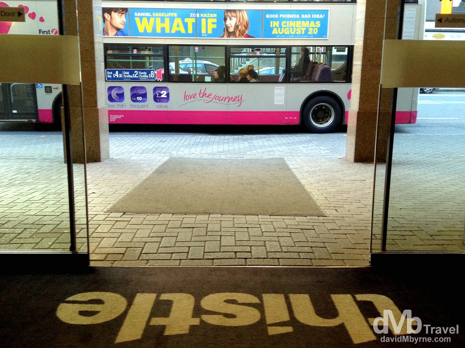
Thistle Hotel, home in Glasgow. It’s nice & it couldn’t be more central. But it’s not ‘luxury’ as its website claims. About the only thing luxury here are the bar prices. But beggars can’t be choosers, only boozers. Glasgow, Scotland. September 10, 2014.
Day 2 || September 11, 2014
Posting Location: Glasgow, Scotland
Wow. We walked a lot of kilometres today (our dogs were definitely barking over dinner tonight) although they still call them miles here in Glasgow. Having driven most of Glasgow’s streets last night in search of our hotel today we walked them. We also walked both banks of the city’s Clyde River. We saw quite a lot of what is an undeniably nice city. The weather helped; it was a truly beautiful day. I got sunburn. I’ve a lot more good things to say about Glasgow that I’ll eventually get round to posting but for now here’s a picture I captured today when we stumbled upon an independence rally outside the city centre Royal Glasgow Concert Hall. It got quite boisterous at times. I’m not sure which side will with the September 18th referendum but today at least in Glasgow City Centre the ‘No’ campaign had the definite advantage. It wasn’t even close.

‘Yes’ or ‘No’? Scots will decide on September 18 and I’ll be here in the country when they do. Independence rally outside The Royal Glasgow Concert Hall in Glasgow, Scotland. September 11, 2014.
– U.K. Prime Minister David Cameron
Day 3
We leave Glasgow in the morning but we won’t be going too far. We’re heading to Edinburgh, the capital, via Stirling. They both boast castles. Two castles in the one day. It’s going to be another busy one. I’m Loving Scotland so far.
Day 3 || September 12, 2014
Posting Location: Edinburgh, Scotland
Today, day 3 of the road trip, was all about cities, medieval castles & battles. We left Glasgow for Bannockburn & Stirling before continuing to Edinburgh, our present location. Here are a few pictures from the day that was.
Bannockburn || The Battle Of
On June 23 1314 King Edward II of England marched north to regain control over the Scots, led by King Robert I, aka Robert the Bruce. The Battle of Bannockburn was a turning point for the beleaguered Scots who routed the far superior English force over the course of the two-day battle. It was a significant Scottish victory in the First War of Scottish Independence and a landmark in Scottish history – the Scots would go on to finally win their independence in 1328. Today the memorial to the battle sits in a field just south of Stirling, somewhere we stopped en route to Stirling Castle.
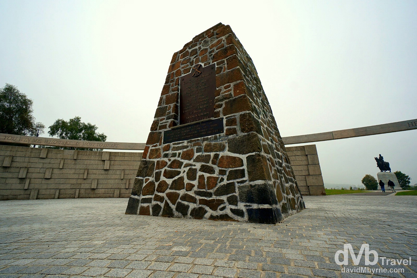
The Battle of Bannockburn Memorial, Bannockburn, Scotland. September 12, 2014.
Stirling & Stirling Castle
Stirling is one of the most striking cities in Scotland, clustered as it is around a large castle, Stirling Castle, and a medieval old-town. Historically the castle was strategically important because it guarded the lowest crossing of the River Forth, the strategic link between Highlands & Lowlands. The castle has seen a lot of strife since it was built in the early 12th century. However, things are a little more peaceful & today the castle, one of the largest and most historically & architecturally important castles in Scotland, is one of the country’s biggest draws.
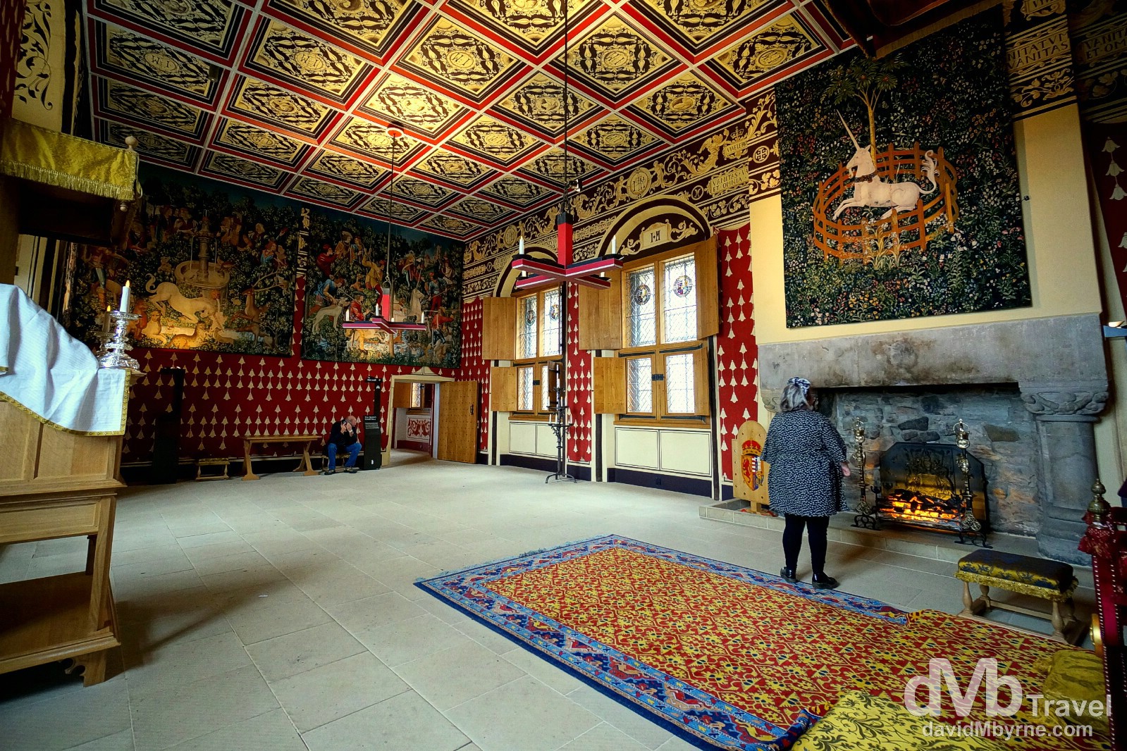
A restored room in the Palace of Stirling Castle. Originally built in the 1540s, Stirling Castle’s Palace rooms, where the King & Queens lived & entertained guests, have been immaculately restored and give a great insight into medieval palace life (the whole castle does). Several Scottish Kings and Queens have been crowned at Stirling, including Mary, Queen of Scots, in 1542. Stirling Castle, Stirling, Scotland. September 12, 2014.
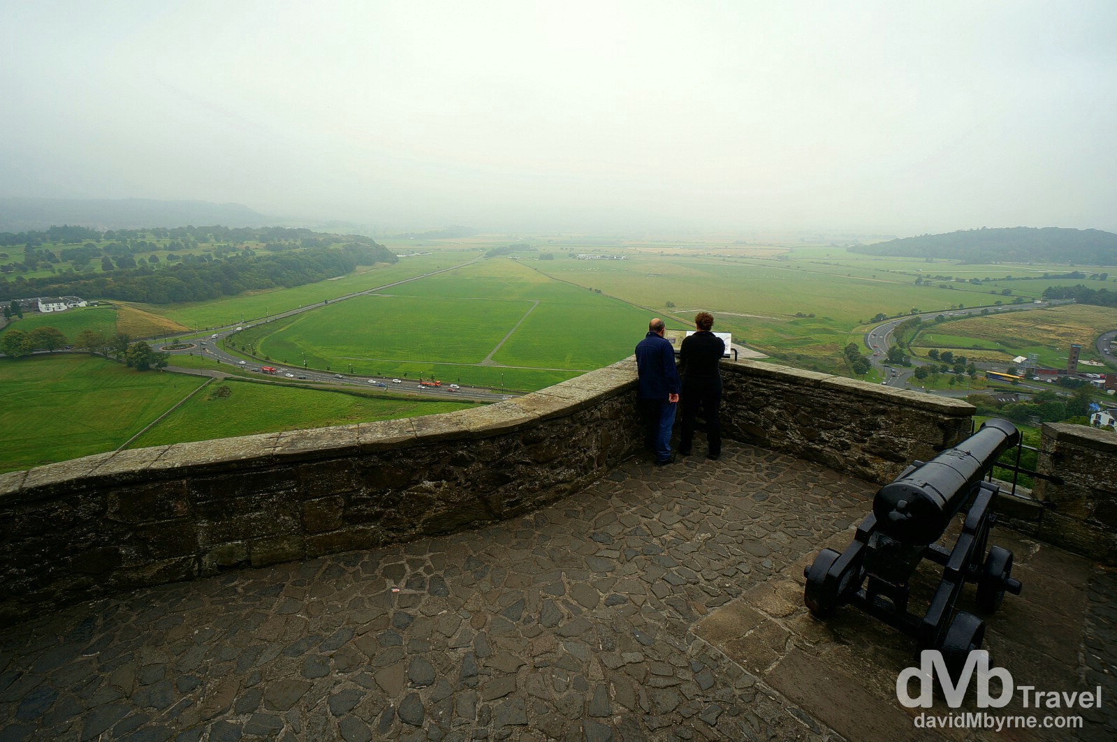
Stirling Castle sits atop Castle Hill, an intrusive crag, & is surrounded on three sides by steep cliffs. This not only means it offered a great defensive position but also great views of the surrounding countryside. There have been at least eight sieges of Stirling Castle, including several during the aforementioned Wars of Scottish Independence, with the last being in 1746, when Bonnie Prince Charlie unsuccessfully tried to take the castle. This is a view from the so-called Ladies’ Lookout, where the ladies of the court would come to admire the views and look down over a constant flurry of more humble activities in the fields below. Stirling Castle, Stirling, Scotland. September 12, 2014.
Edinburgh || The Capital
– UNESCO commenting on the Old and New Towns of Edinburgh
Arriving in the capital late in the afternoon meant we didn’t have time today to visit the city’s main event, its castle – we’ll get around to that tomorrow (tickets have been bought already). But we did visit a nice cathedral & hung around the Royal Mile, the name given to a succession of streets forming the main thoroughfare of the Old Town of the city.
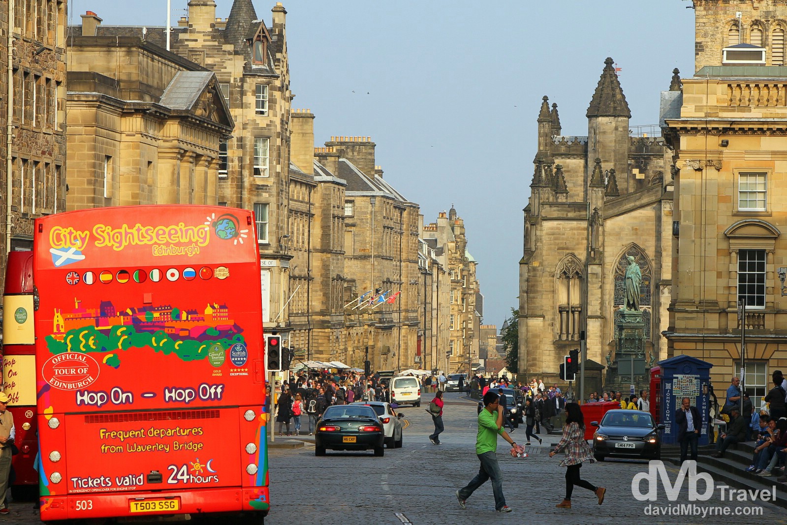
Royal Mile, Edinburgh, Scotland. September 12, 2014.
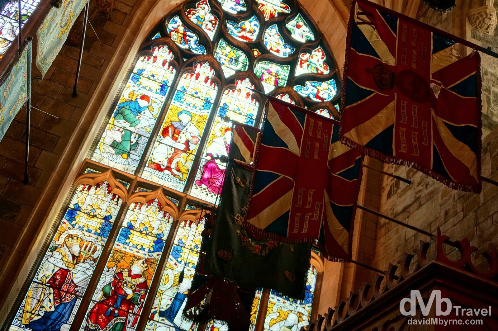
A section of the interior of St. Giles Cathedral, the principal place of worship of the Church of Scotland in Edinburgh. I had to pay £2 to take pictures in here but it was money well spent. Edinburgh, Scotland. September 12, 2014.
Forth Rail Bridge
Ten miles outside Edinburgh are the Forth Bridges, the road & rail bridges spanning the Firth of Forth. We took a spin over the road bridge this evening. We’ll be doing the same again tomorrow en route to the Highlands but I wanted to capture the massive rail bridge at night. So I did, although only just – I managed a few shots just before dense fog completely enveloped the massive iconic structure, a symbol of Scotland.
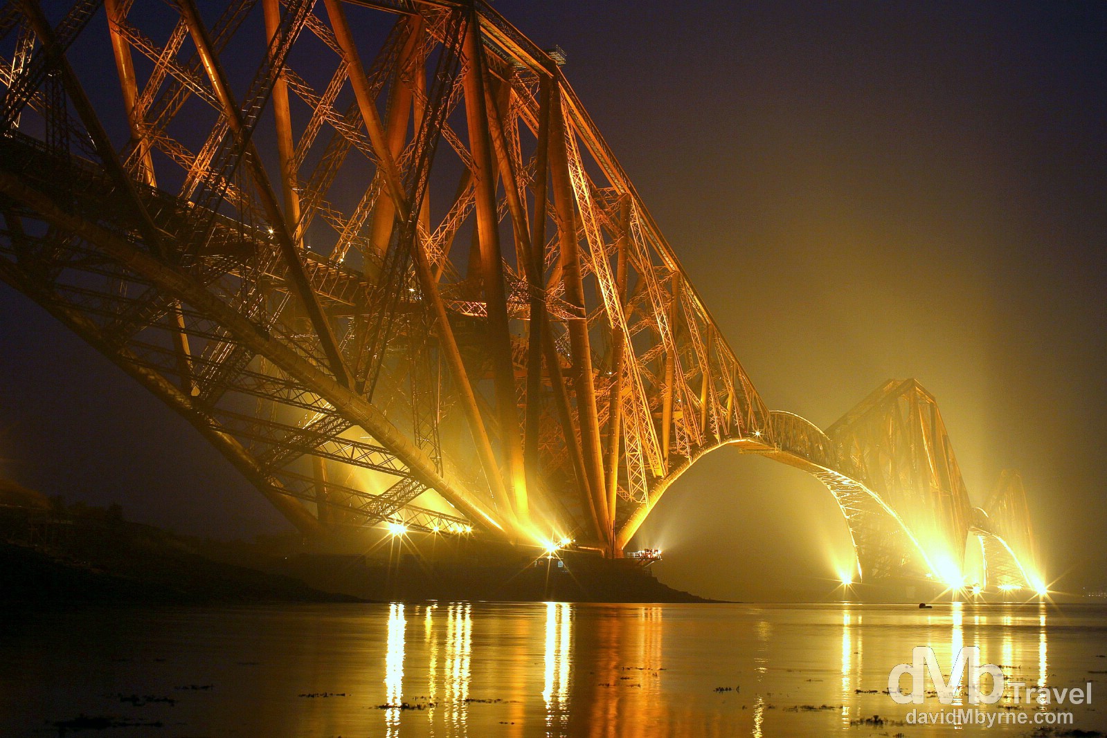
The Forth Bridge, a cantilever railway bridge with a span of 2.5 kilometres, was opened on 4 March 1890. It took 7 years to build with the cost of 63 lives. Until 1917, when the Quebec Bridge in Quebec, Canada, was completed, the bridge had the longest single cantilever bridge span in the world – it still today has the world’s second-longest single span. The bridge is, even today, regarded as an engineering marvel and standing this close to it while photographing it in the near darkness was awesome. Forth Rail Bridge crossing the Firth of Forth, Scotland. September 12, 2014.
Day 4
Tomorrow should bring a change of scenery. We’re leaving the cities & heading north, for the Highlands. Upwards & onwards.
Day 4 || September 14, 2014
Posting Location: Aviemore, Scotland
Today was a busy day. A long one too. I was up early, up for sunrise views over Edinburgh from the city’s Calton Hill. It was glorious, a great start to the day.
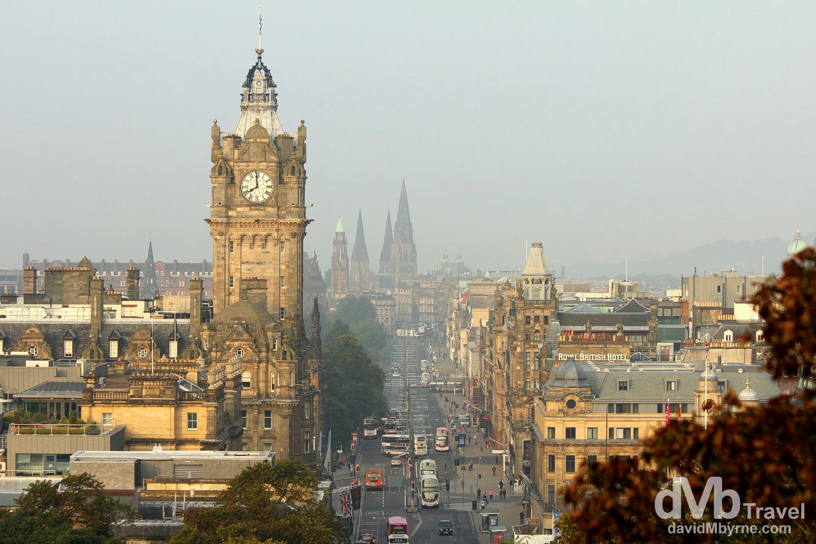
Morning activity on Princess Street as seen from Calton Hill in Edinburgh, Scotland. September 13, 2014.
After a whopping breakfast we spent the morning looking around the awesome Edinburgh Castle, getting out of there as the crowds peaked (that castle gets busy). We then drove back across the Forth Road Bridge, with a quick stop to take a few more pictures of the neighbouring rail bridge. It still looked great, even without last night’s darkness & fog/mist. We then headed for the hills, our first taste of the Scottish Highlands, via Cairngorms National Park. We passed Balmoral, summer retreat of the Queen, a few ski resorts (closed this time of year of course), & more than a few interested bystanders.
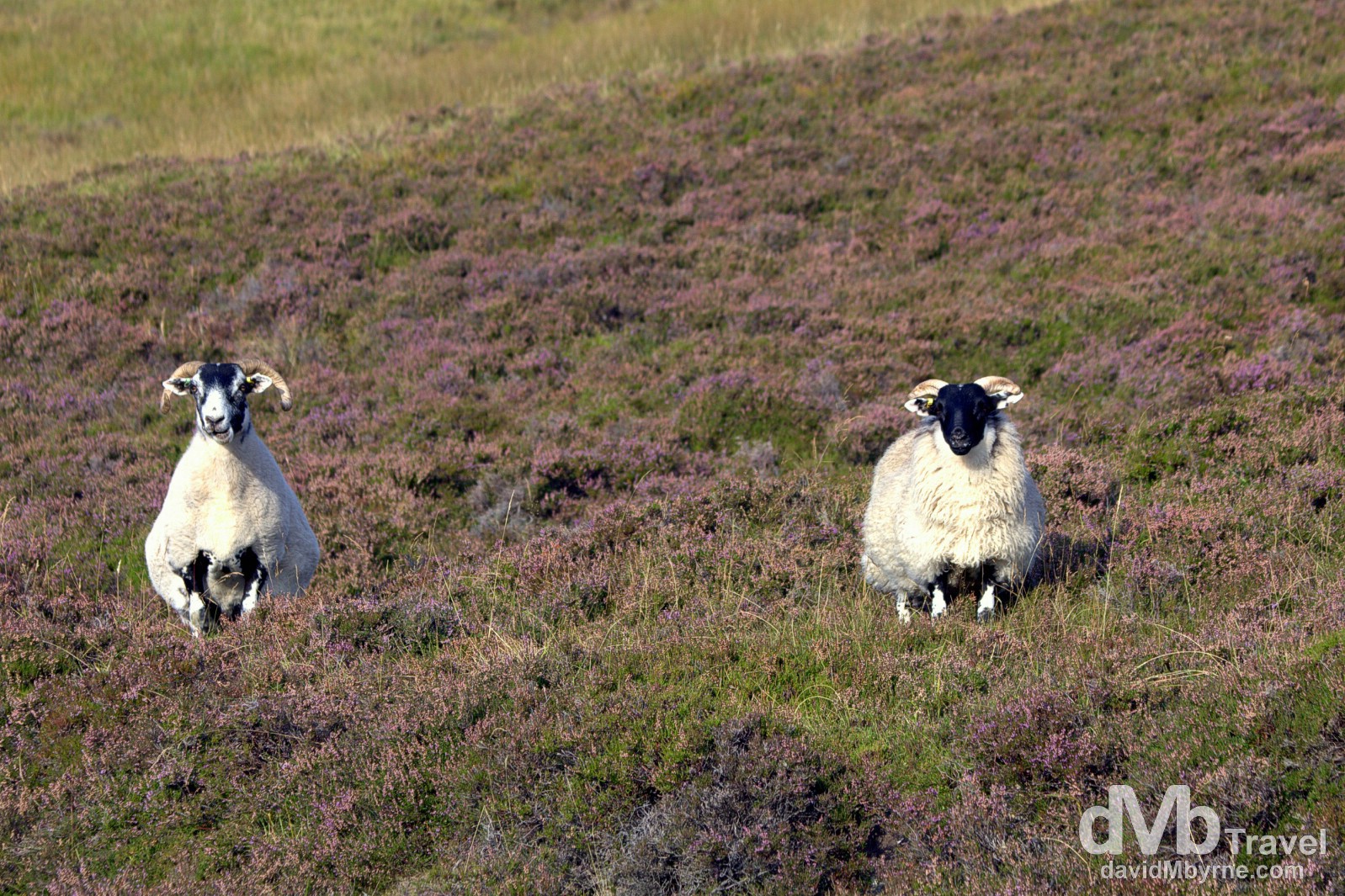
Interested bystanders. Sheep among the heather by the side of the A93 road in Cairngorms National Park, Scotland. September 13, 2014.
The scenery en route today, on the so-called Highland Tourist Circuit, was always nice helped again by the beautiful weather; we’ve been so lucky weather wise thus far.
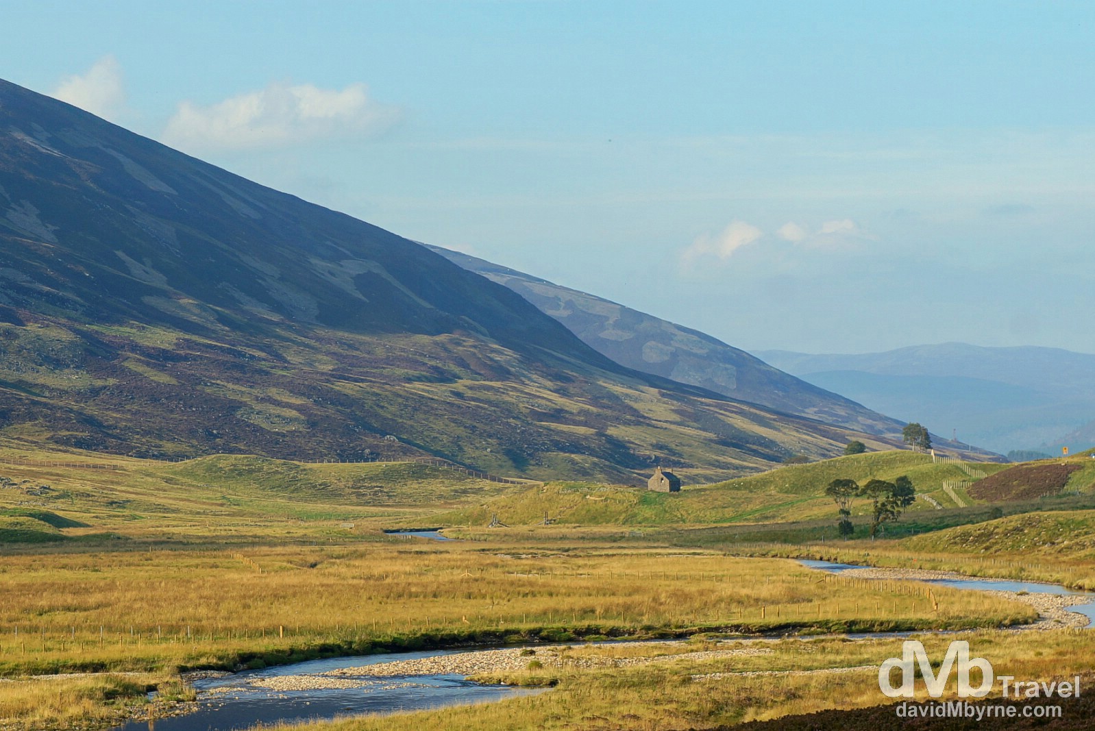
A big change of scenery from the cities of Glasgow & Edinburgh. Scenery in Cairngorms National Park as seen from the A93 en route to Aviemore, Scotland. September 13, 2014.
Aviemore
The Highland Tourist Circuit brought us to our day 4 overnight stop of Aviemore. We expected the town, Scotland’s original Highland tourist resort, to be a little livelier than it is. After all, it’s a big enough place, it was a Saturday, & it’s Highland Homecoming time, a two-month (September & October) celebration, part of the wide Homecoming 2014, of the very best in contemporary Scottish culture and Highland heritage. We’ve more of the Highlands to discover so maybe we’ll yet stumble upon some of the ‘wonderfully diverse array of events covering everything from arts and music festivals to Highland games, sporting extravaganzas, delicious food and drink’ (as per VisitScotland.com) that the Highland Homecoming offers.
To The Very Top
We continue heading north tomorrow, Day 5. We’ll go as far north as Scottish mainland Scottish terra firma will allow. Easter Head on Dunnet Head is our main destination for the day, the most northerly point of the mainland of Great Britain. It’s not too far from the much better known John o’ Groats. We’ll stay up there somewhere tonight. We’re not sure where. We’ll figure that out when we get there.
Day 5 || September 14, 2014
Posting Location: Thurso, Scotland
It’s quiet here in Thurso, the most northerly town in mainland Scotland (& thus mainland Britain), where we arrived earlier this evening. It took us the guts of 4 hours to drive here from Aviemore via stops in Wick (for lunch), John O’Groats (to wonder why people like us stop here at all), & Dunnet Head, just out the road. For the most part it was yet another beautiful day in this remote, sparsely populated corner of planet earth. Weather wise we reckon someone is smiling down on us and both my Dad and I think we know who that might be.
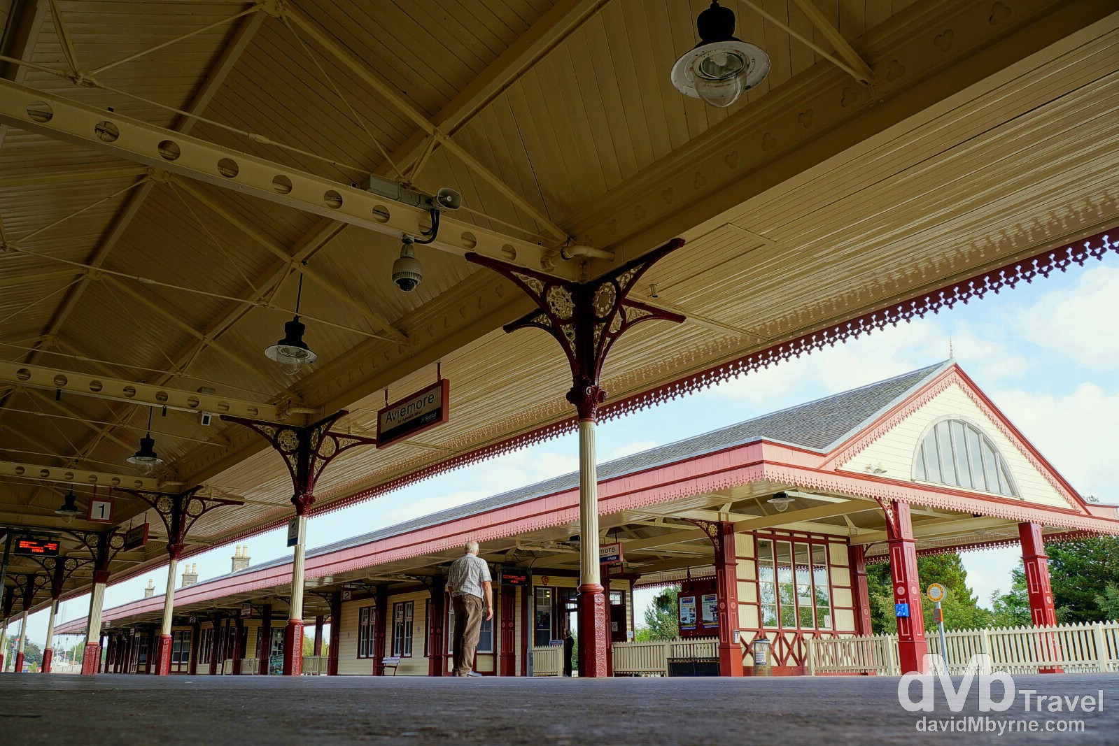
Before we hit the road for day 5 of the road trip we had a look around Aviemore, including its Victorian era train station. The station was built in the 1860s as part of the expansion of the rail line north to Aviemore, opening up the region to travellers from the south. The well preserved & beautifully presented station hasn’t changed much since those days and is a must-see for anyone paying a visit to the town even if, like us, you do so just before hitting the road to leave the town. Aviemore, Scotland. September 14, 2014.
– From an information board outside the train station in Aviemore.
We spent most of today skirting the Highland coast with the North Sea to our right. We crossed a few bridges, three to be precise. The scenery was nice.
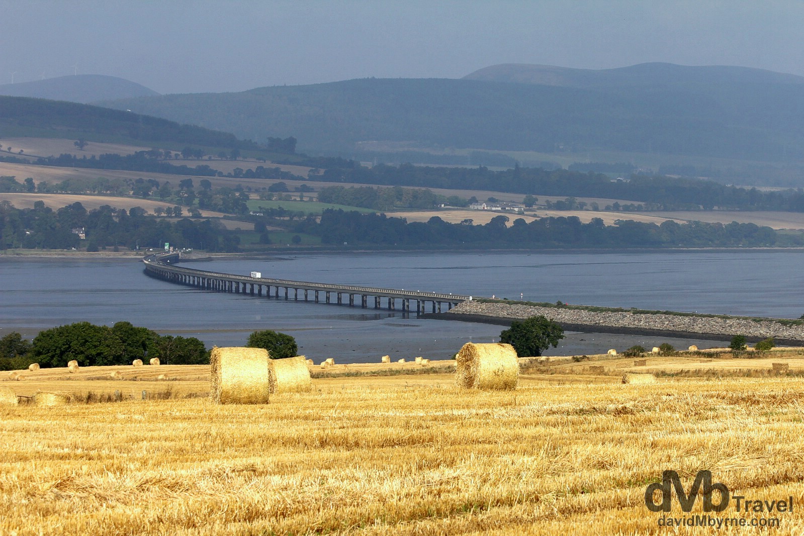
Scenery near the Comarty Bridge crossing Cromarty Firth north of Inverness. We’ve seen a lot of fields full of bales of straw over the past few days. A lot of fields & a lot of bales. September 14, 2014.
John O’Groats || The End of The Road
Yes, we came all this way to see a pole. You probably would too. Although we had an easier time getting here than some others did.
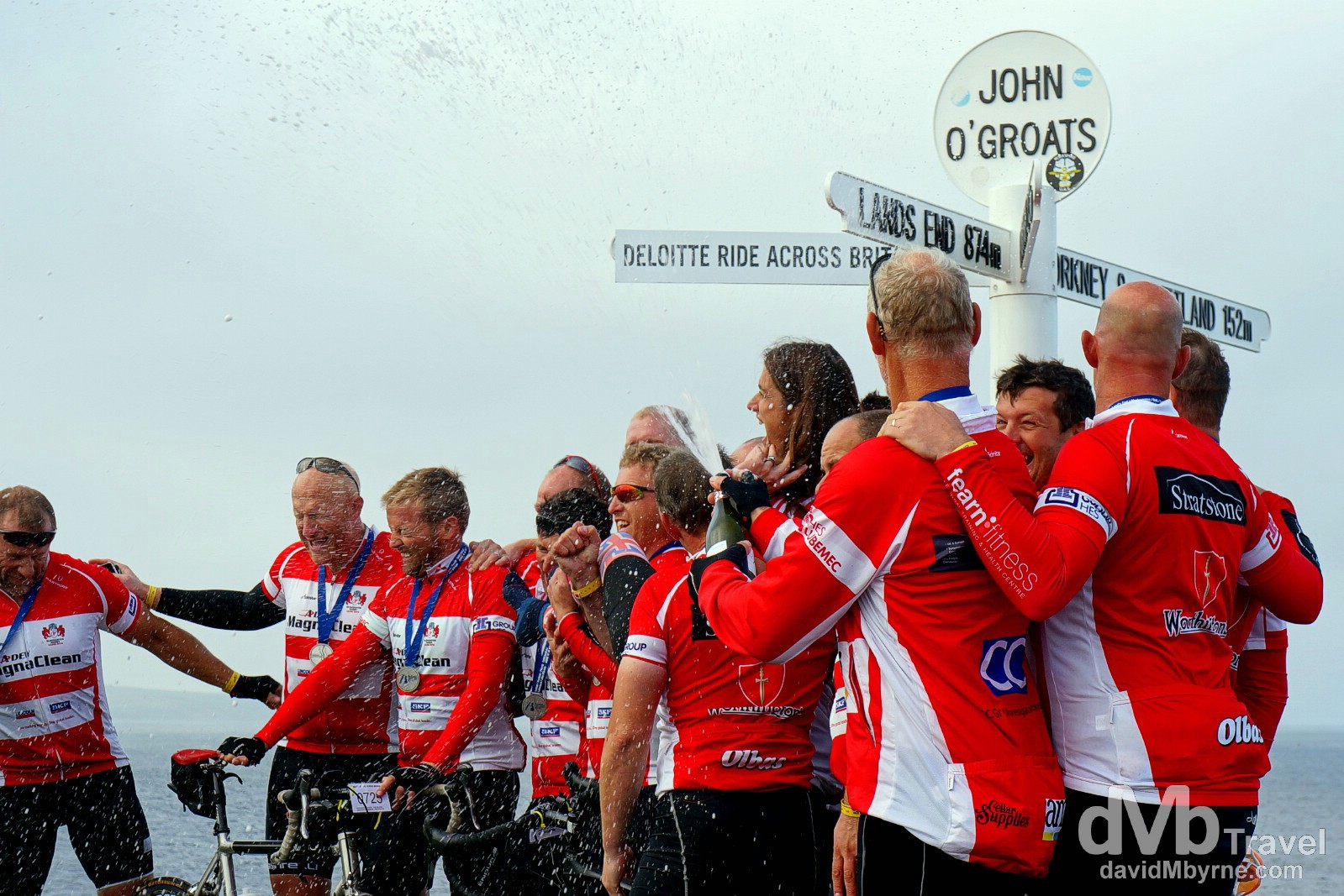
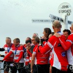
Having now visited, we’re still not too sure why John O’ Groats is as popular as it is. It’s nothing more than a small village comprising of a few houses, a hotel, postcard racks, a small harbour & a post that everyone stands under to get their picture taken. I guess it’s popularity is due to the fact that it’s the ‘End of The Road’; this officially marks the northern end of the 874 mile stretch from Land’s End, the greatest road distance between two points on the British mainland. It name derives its name from a Dutchman, John De Groot, who is said to have, in the 15th century, run the first ferries to the Orkney Islands just off the coast (we saw a ferry leaving as we were walking around). Groot built a house here, an area today marked by the distance pole seen here, beside which a hotel was built in 1875. On this particular day the area was alive with cyclists finishing the 9-day, Land’s End to John O’Groats cycle, the Deloitte Ride Across Britain 2014. Those waiting in line to have their celebratory picture taken by the pole added a little something to my picture of what otherwise would just have been a pole. John O’Groats, Scotland. September 14, 2014.
Dunnet Head || The Most Northerly Point on the British Mainland
No, no. This, Dunnet Head, is why we really came up here.
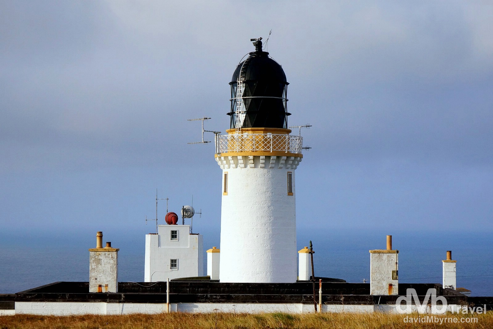
Dunnet Head is geographically 2.35 miles north of John O’ Groats, and some 7 miles along the coast, making it the most northerly point of the Scottish, and thus British mainland. Needless to say it’s a remote, windswept place with the sea constantly battering the cliffs. The lighthouse seen here, one of over 200 located along the wild, 6000+ mile Scottish coastline, was built in 1831 by Robert Stevenson, grandfather of Treasure Island author Robert Louis Stevenson, and has been unmanned since 1989. Dunnet Head, Scotland. September 14, 2014.
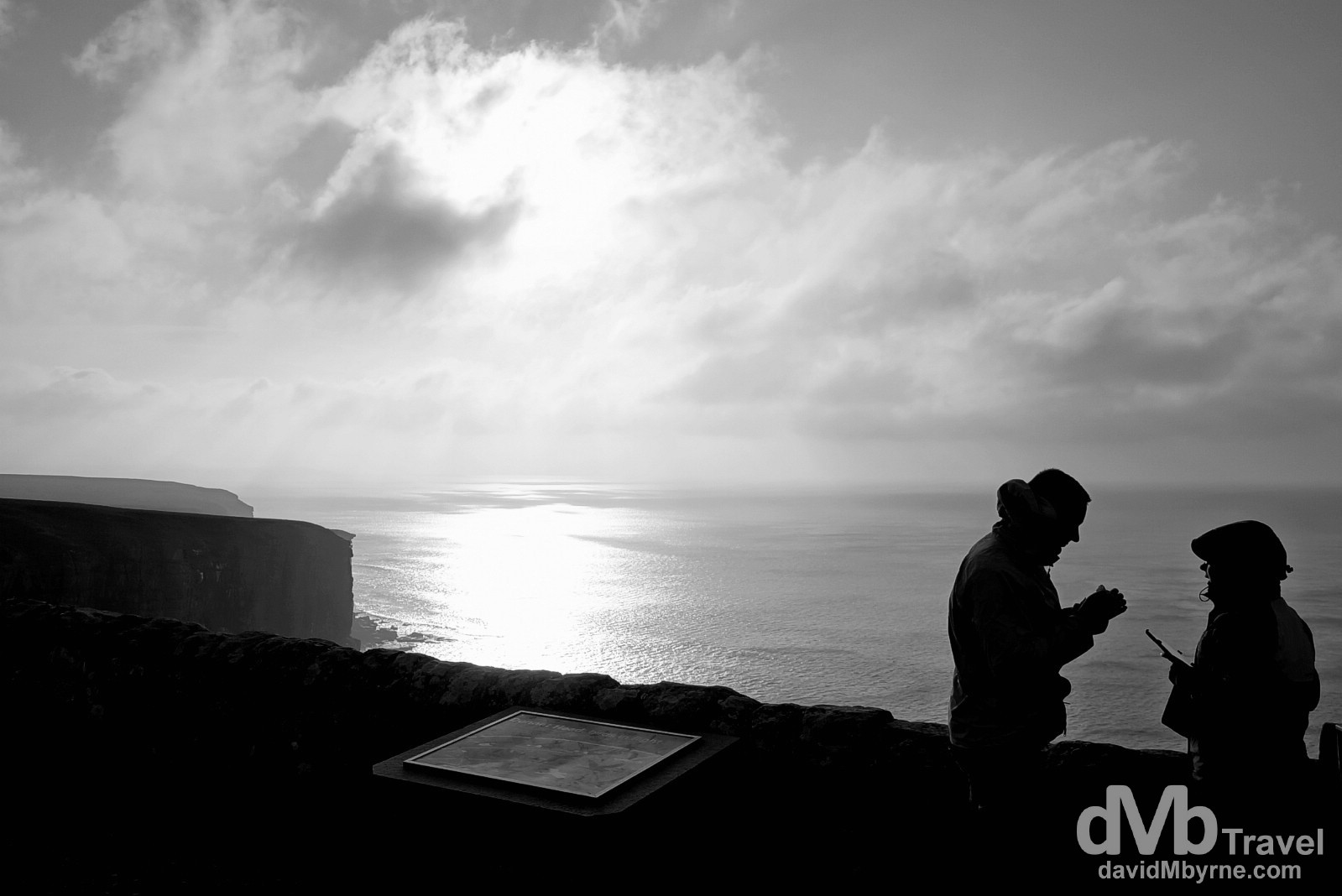
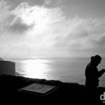
Silhouettes at Dunnet Head, the most northerly point on the British mainland. Dunnet Head, Scotland. September 14, 2014.
Day 6 || The Sutherland Unknown
We’ve gone as far north as we can go in Scotland without hopping on a ferry to the Orkney or Shetland Islands further north (maybe next trip). We’ll be heading west & south from now on, with tomorrow spent driving the great unknown (for us) of Sutherland, the sparsely populated region in the very north of Scotland. We have a few maps of the area, none of which show many roads. We’re just going to drive and see what’s out there, just like a road trip should be.
Day 6 || September 15, 2014
Posting Location: Ullapool, Highlands
There was a decidedly older, more mature crowd in the dining room of the Station Hotel in Thurso this morning. I felt like I was eating breakfast in a retirement home. Shortly after breakfast was done we were on the road again for the day, but not before having a look around the pretty centre of Thurso.
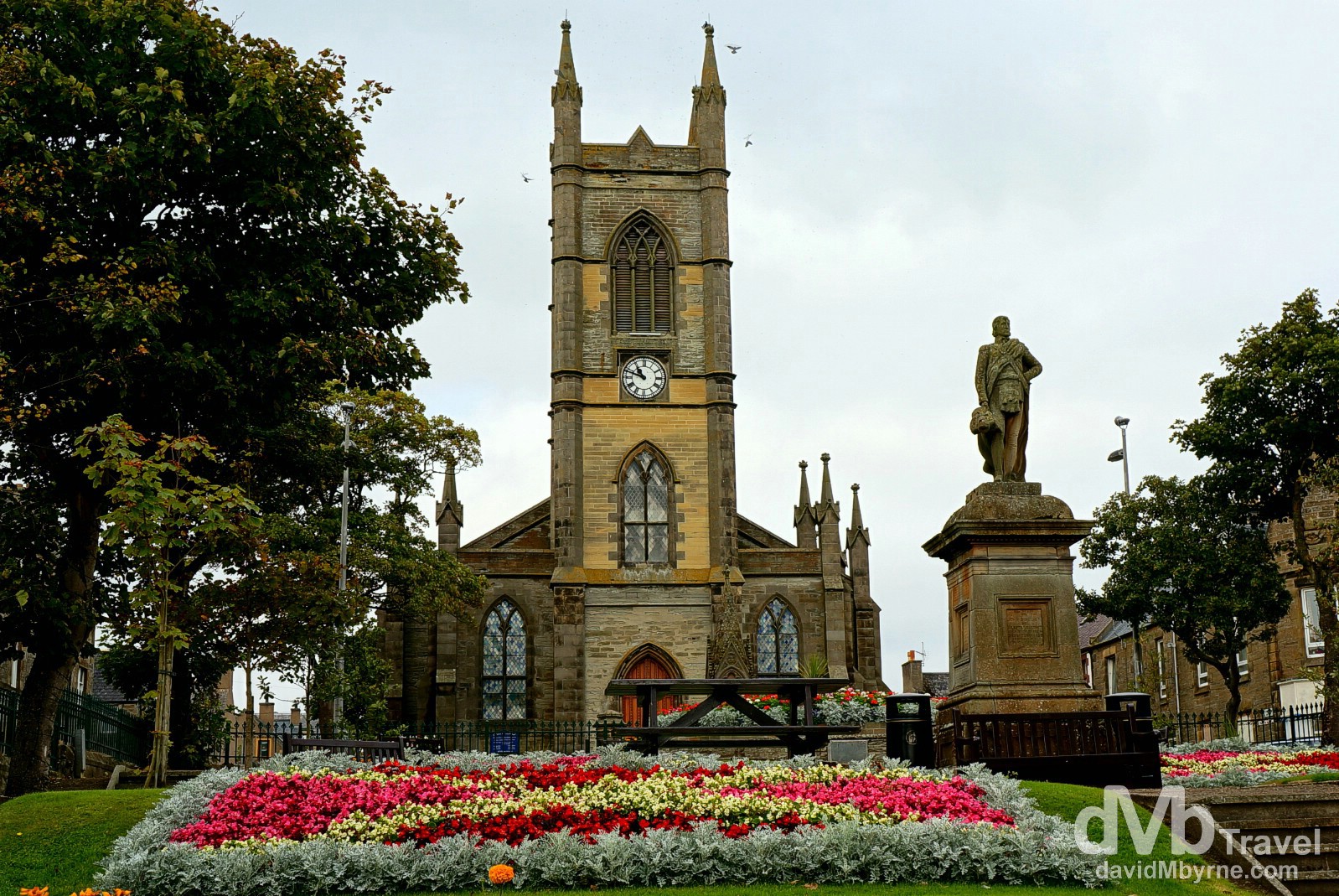
Thurso, the most northerly town in mainland Scotland, is a nice place. Quiet too; not too many people venture up here, and most who do are passing through en route to the Orkney or Shetland Islands offshore. The small town is dominated by the beautifully presented Sir John Square, a civic space gifted to the town by Sir Tollemache Sinclair in 1879. The statue seen here in the square’s centre is that of Sir John Sinclair. It was added in 1893 at which time the square was renamed in Sir John’s honour – it was originally known as MacDonald Square. The square is overlooked by the St. Peter’s & Andrew’s Church which dates from the early 1830s. Thurso, Caithness, Highland, Scotland. September 15, 2014.
196 miles we drove today getting from Thurso to Ullapool, our overnight location for this day, day 6 of the road trip. We skirted the northern Atlantic Ocean coast for much of the day. Again we were blessed with the weather. And sights. In this remote part of the country we got to see everything from rocky headlands to sandy beaches to massive locks to mammoth caves. Oh, and we saw some iconic Highland cattle too.
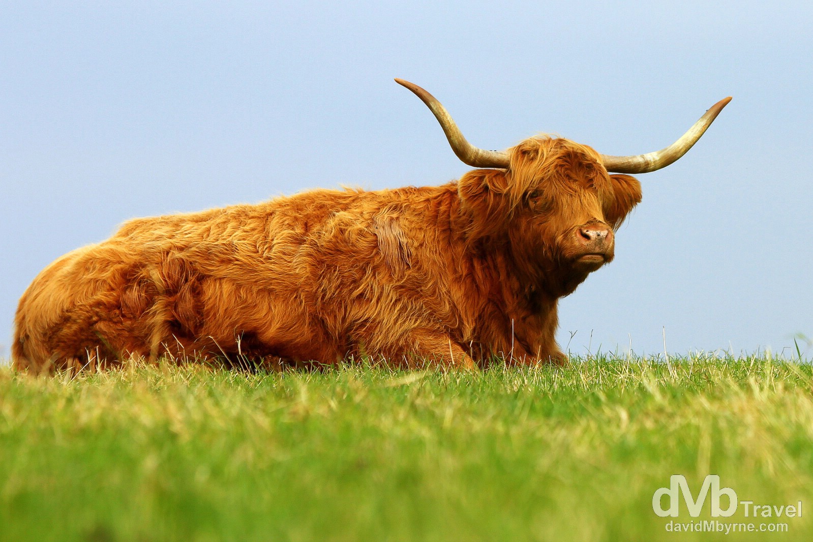
Developed in the Scottish Highlands & Western Isles, the long pointy horns & long wavy coats of Highland cattle are a classic Scottish Highland sight. We’ve only yet seen rusty red coloured cattle but seemingly there are black variations too. They are hardy creatures, able to withstand the worst of Highland weather (it gets cold, wet & very windy up here) although on this particular day this particular Highland red was enjoying the September afternoon sunshine while keeping a close eye on me across the field. A red Highland in a field outside the village of Reay, Caithness, Highland, Scotland. September 15, 2014.
North West Highlands
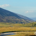
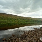
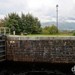
Driving from east to west on the A838, this is one of the first views you get of 16 kilometre long Loch Eriboll, one of the deepest sea locks in Britain that has been used by Royal Navy ships for safe & sheltered anchorage.
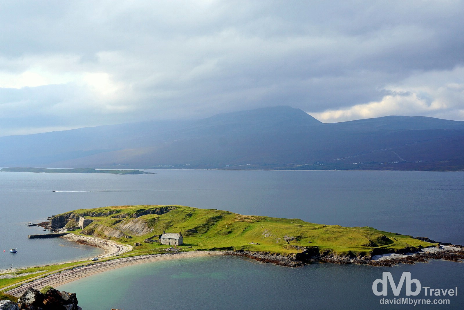
The lock’s dominant feature is the Ard Neakie headland seen here, on which still stands an isolated farmhouse & the remains of a 19th century kilin where local limestone was heated to produce lime. Overlooking Loch Eriboll, Sutherland, Highland, Scotland. September 15, 2014.
It’s remote up here. There aren’t too many roads & those that are here are narrow, windy affairs with regular so-called passing places, areas where one car can wait to allow another to pass – few roads are wide enough for 2 cars.
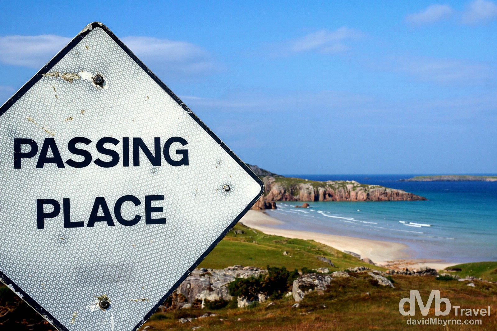
At one stage today we questioned whether we were on the right road before realising there only was one road. It’s that kind of region. This picture was captured near a sandy headland outside the village of Durness in the extreme north-west of the country. This region of Sutherland is one of the most sparsely populated areas in Europe & an area of some 800 square miles of it was awarded Geopark status in 2004, a status awarded to sites worldwide with outstanding landscapes and geological heritage of international significance. Passing Place sign on the narrow A838 road in Sutherland, Highland, Scotland. September 15, 2014.
– Extract of ‘Glen Golly’ composed by Rob Donn (1714-1778) of North Sutherland in praise of a local glen & on display at the Smoo Cave
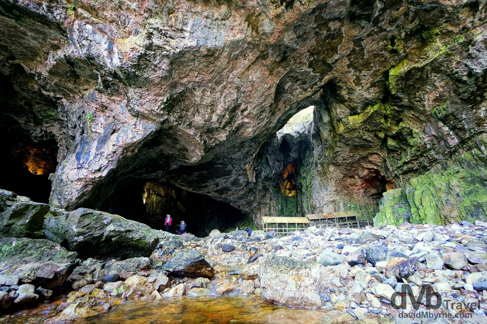
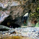
Smoo Cave is a large combined sea & freshwater cave, the largest sea entry cave in the U.K. It was formed over many thousands of years by erosion. The floodlit cave is unique in the U.K. in that has two chambers, the larger chamber seen here (formed by erosion from the sea) & a smaller, second inner chamber formed by rainwater erosion. Access to the 40 metre wide, 15 metre high main chamber is free to all and during the summer months the inner chamber, accessed via the covered walkway seen to the right, can be explored by boat for a small fee. Sutherland, Highland, Scotland. September 15, 2014.
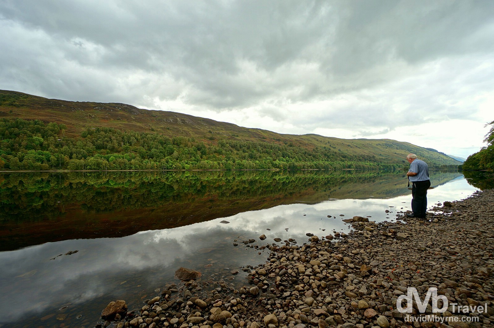
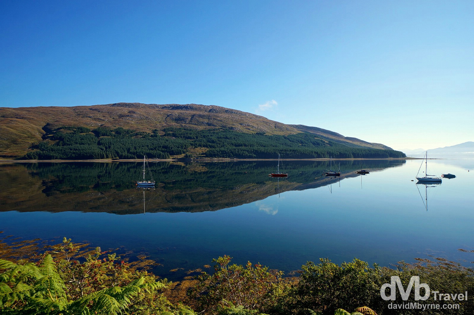
We mixed it up a bit in getting here to Ullapool; we left the coast and took an inland route past lochs, through glens & around mountains. It was still very remote, the scenery was still strikingly beautiful, but unfortunately the weather wasn’t as good as it was on the coast. Indeed today marked the first day of the trip we saw rain. Not much though and not for too long. It’s a nice evening here in Ullapool where we’ll bed down for the night. The forecast is good for tomorrow, trip day 7, when we’ll be zigzagging back & forth across the country in a bid to get from here to the Isle of Skye via Loch Ness. That’s the plan anyway & everything has been going to plan thus far.
Day 7 || September 16, 2014
Posting Location: Kyle of Lochalsh (Klye), Highlands
Today, day 7 of the road trip, was a day of reflections. They were everywhere. It was eye candy feast the likes of which I have never before experienced. And it started early. Not long after first light I found myself on the shores of Ullapool harbour photographing reflections, which had me reflecting on past travels.
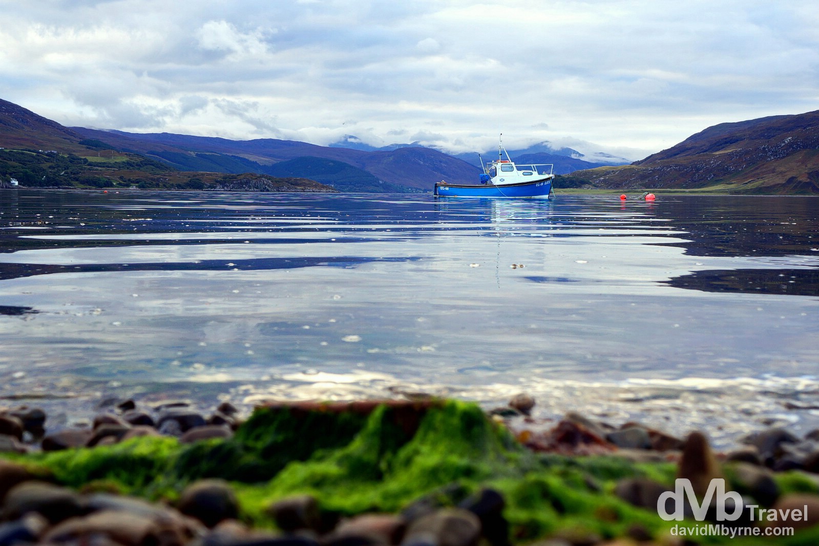
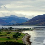
A lone boat in the Ullapool harbour. The town’s setting, on the water surrounded by misty peaks, reminded me to Lake Wanaka on New Zealand’s South Island, another remote, stunning location on planet earth that I’ve been fortunate to visit a few times. Ullapool, Highlands, Scotland. September 16, 2014.
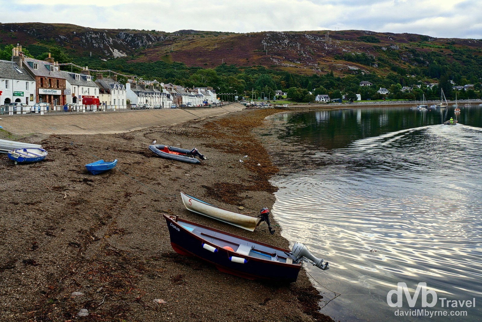
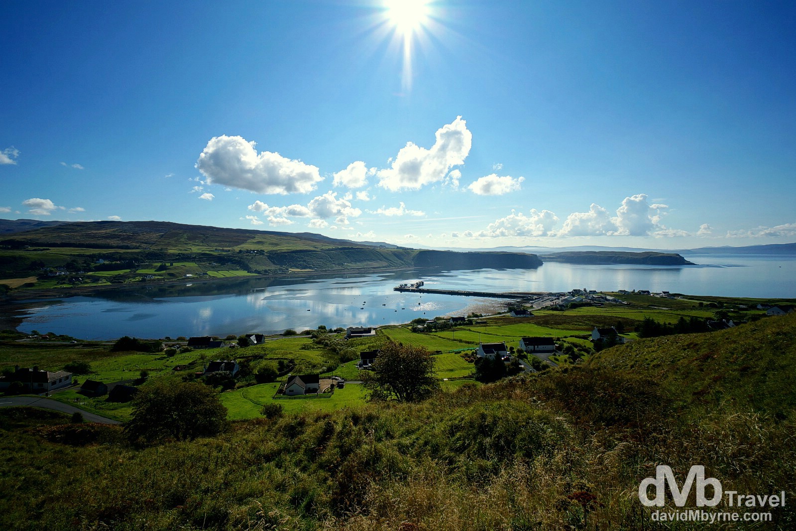
Ullapool is a charming coastal town on Scotland’s western seaboard making it a great & popular base for exploring the region. It’s a small place (only some 1,500 inhabitants) but it’s still the largest settlement for many miles. Established as a fishing village in 1788 by the British Fisheries Society, the town has undergone periodic booms & declines over the years – it boomed during WWII, when fishermen flocked here to avoid the more dangerous waters of Scotland’s East Coast, & again in the 70s when the massive Eastern Bloc ships, aka the Klondykers, anchored in the bay processing mackerel. Today it’s a still a busy fishing & ferry port, with daily passenger, car & freight ferries serving the Isle of Lewis in Scotland’s Outer Hebrides. Ullapool, Highlands, Scotland. September 16, 2014.
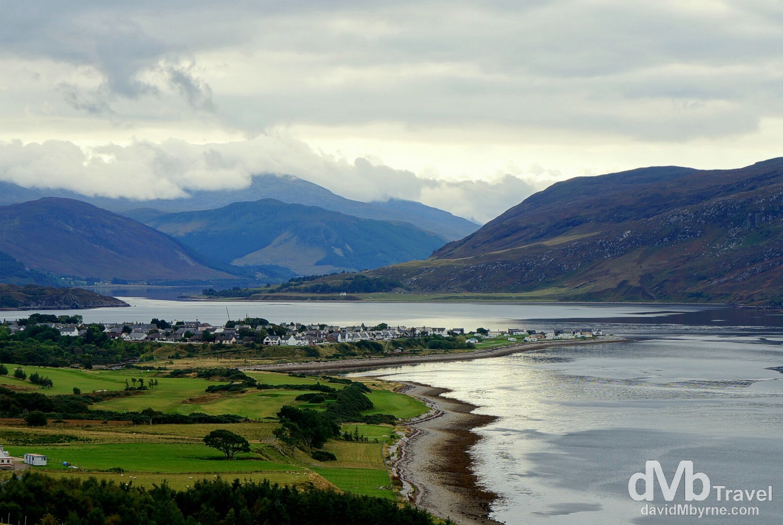
Before hitting the road for the day (destination the Isle of Skye via Loch Ness) we drove out the road we drove in the previous evening for an overview of Ullapool sitting on the eastern shore of Lock Broom, a long sea lock. It was nice sight last night but an even better one today. The town of Ullapool on the eastern shore of Lock Broom as seen from the A835 entering town. Highlands, Scotland. September 16, 2014.
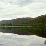
Not long after leaving Ullapool we got more reflections. Pretty special reflections aided by the sun.
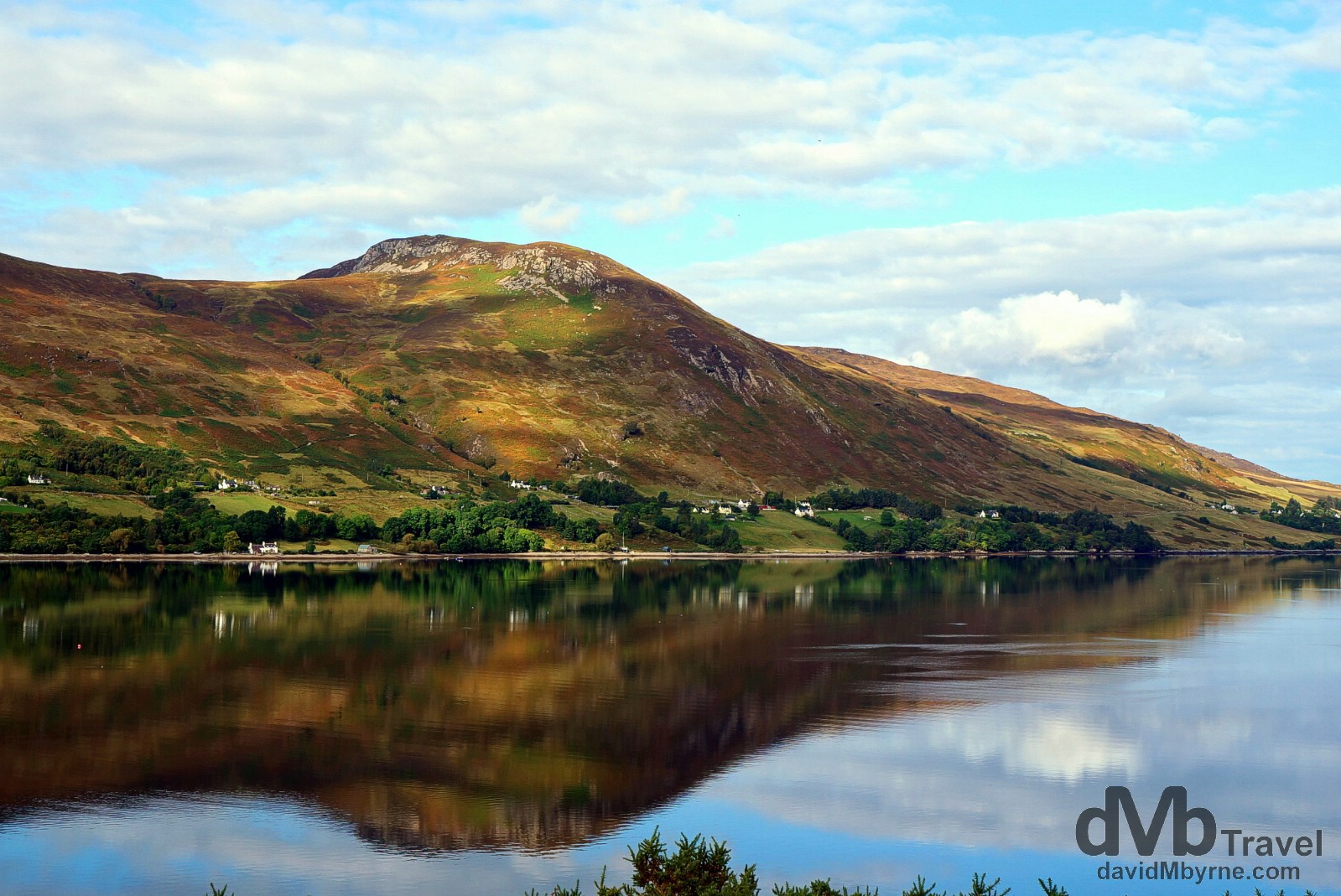
Reflections of the western shore of Lock Broom, Highlands, Scotland. September 16, 2014.
While standing here in almost dead silence photographing the Loch Broom reflections a fighter jet thundered passed. We couldn’t believe it, and barely managed to capture it on camera. You can find what I did capture of it uploaded to my Instagram account here.
Loch Ness & The Loch Ness Centre & Exhibition
The specifics of Loch Ness, probably Scotland’s most famous body of water, are impressive. It’s the second largest of Scotland’s lakes in terms of size (after Loch Lomond) but because of its depth – 230 metres at its deepest point – it is the largest in terms of volume; it holds more fresh water than all the lakes in England & Wales combined. The 37 kilometre long body of water is the largest and most northerly of the three interconnected lakes, waterways for the Caledonian Canal that sit astride the northeast to southwest Great Glen Fault, a massive geological fault in the Earth’s crust that cuts right through the Scottish Highlands. We didn’t cross the fault, staying as we did on the lake’s northern shore – that’s where the road, the A82, is.
The iconic five-storey Grant Tower of the ruins of Urquhart Castle overlooking Loch Ness, a medieval stronghold & one of Scotland’s most visited attractions. Loch Ness, Highland, Scotland. September 16, 2014.
Nessie
Did we see The Loch Ness Monster, a.k.a. Nessie, while driving the lake’s northern shore or while standing above it photographing Urquhart Castle? Of course not, but people far more gullible than us have claimed to with the glut of ‘sightings’ occurring in the 1930s.
– An entry from 1933 on the Loch Ness History timeline of the Loch Ness Centre & Exhibition
Science, not to mention simple logic & a bit of common sense, says such a creature could never really exist. Not today at least. Of course the nearby Loch Ness Centre & Exhibition in the Drumnadrochit Hotel stops short of claiming there really is (or isn’t) a monster beneath the murky lake waters. Instead the exhibitions 7 themed walk through rooms do a good job detailing the history of the mystery, ultimately leaving it up to the visitor to decide for themselves.
– A heads up from The Loch Ness Centre & Exhibition
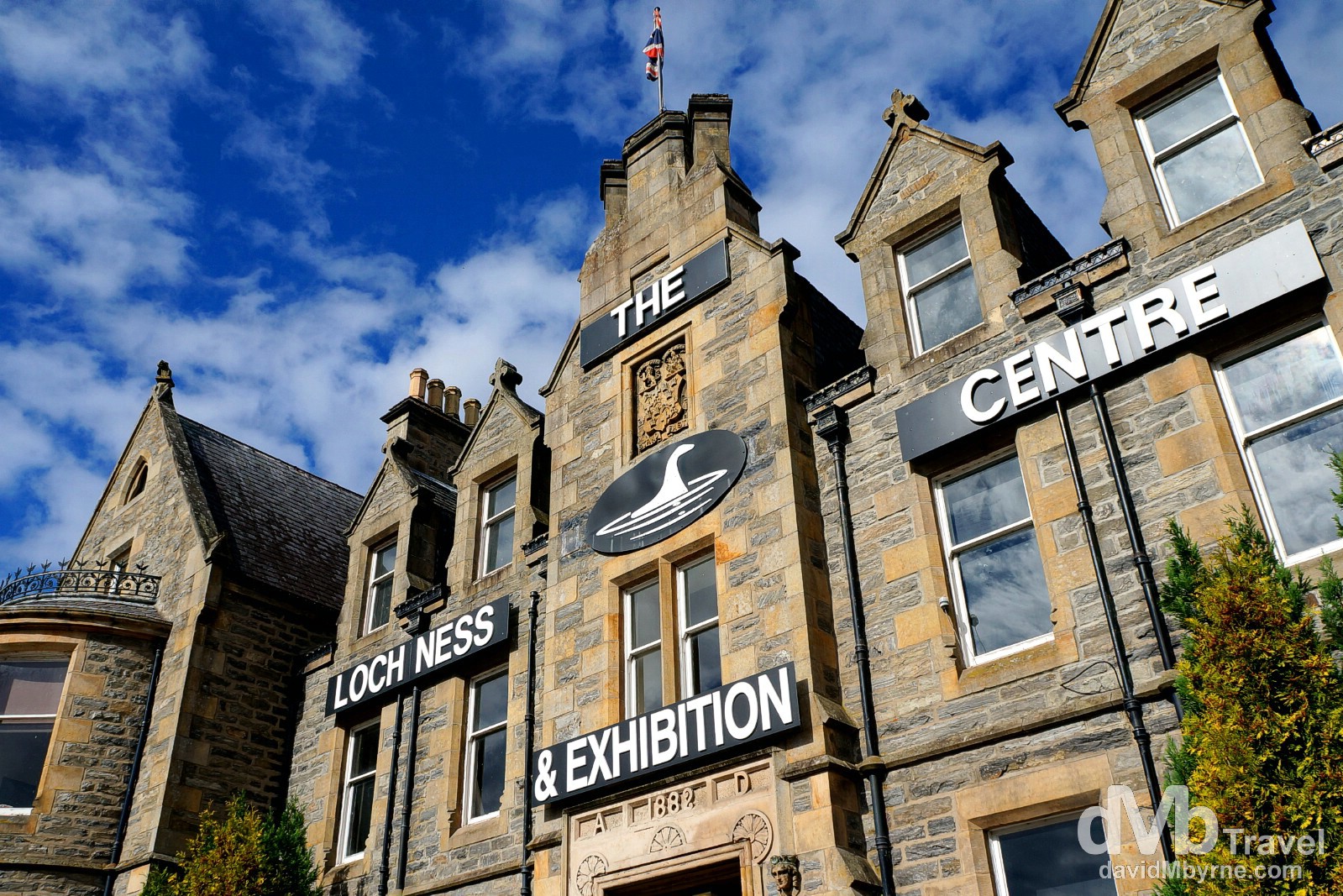
While it’s not the 5 star visitor attraction VisitScotland.com claim it to be, the exhibitions use of animations, lasers & special effects mean it is an entertaining way of passing an hour or so. Oh and of course you get ample opportunity to pick up Nessie-branded, Made in China tat in the shops the exhibition invariably empties you into. The Loch Ness Exhibition Centre at the Drumnadrochit Hotel in Drumnadrochit, Inverness, Scotland. September 16, 2014.
Loch Oich
The best reflections of the day (& that’s saying something) made us pull over the car and stand by the shores of Loch Oich, just a few kilometres beyond Loch Ness.
Admiring the reflections of Loch Oich in Highland, Scotland. September 16, 2014.
This is the second and smallest (it’s only 6 kilometres long) of the three interconnected lakes that sit astride the Great Glen Fault. As with the other two lochs (Loch Ness & Loch Lochy), Loch Oich is also a navigable waterway of the 100 kilometre Caledonian Canal which connects the Scottish east & west coasts. Loch Oich is the highest point of the canal with its level having been artificially raised during canal construction to provide a navigable channel. I’d never seen anything quite like the perfect mirror image projected by the still waters of the loch and stood here for quite a while taking pictures. It was an amazing, peaceful scene, one that was again interrupted this time by 1) a low flying military cargo plane, & 2) light rain.
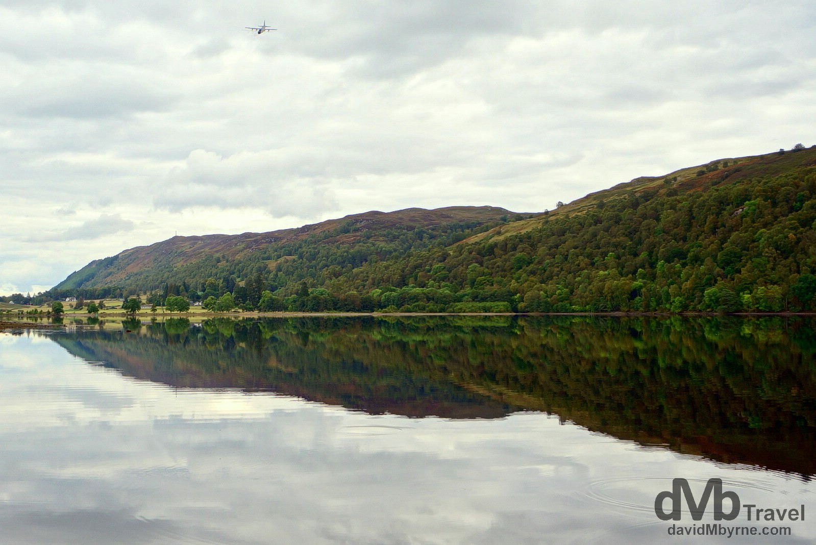
A military cargo plane fly-by over the waters of Loch Oich, Highland, Scotland. September 16, 2014.
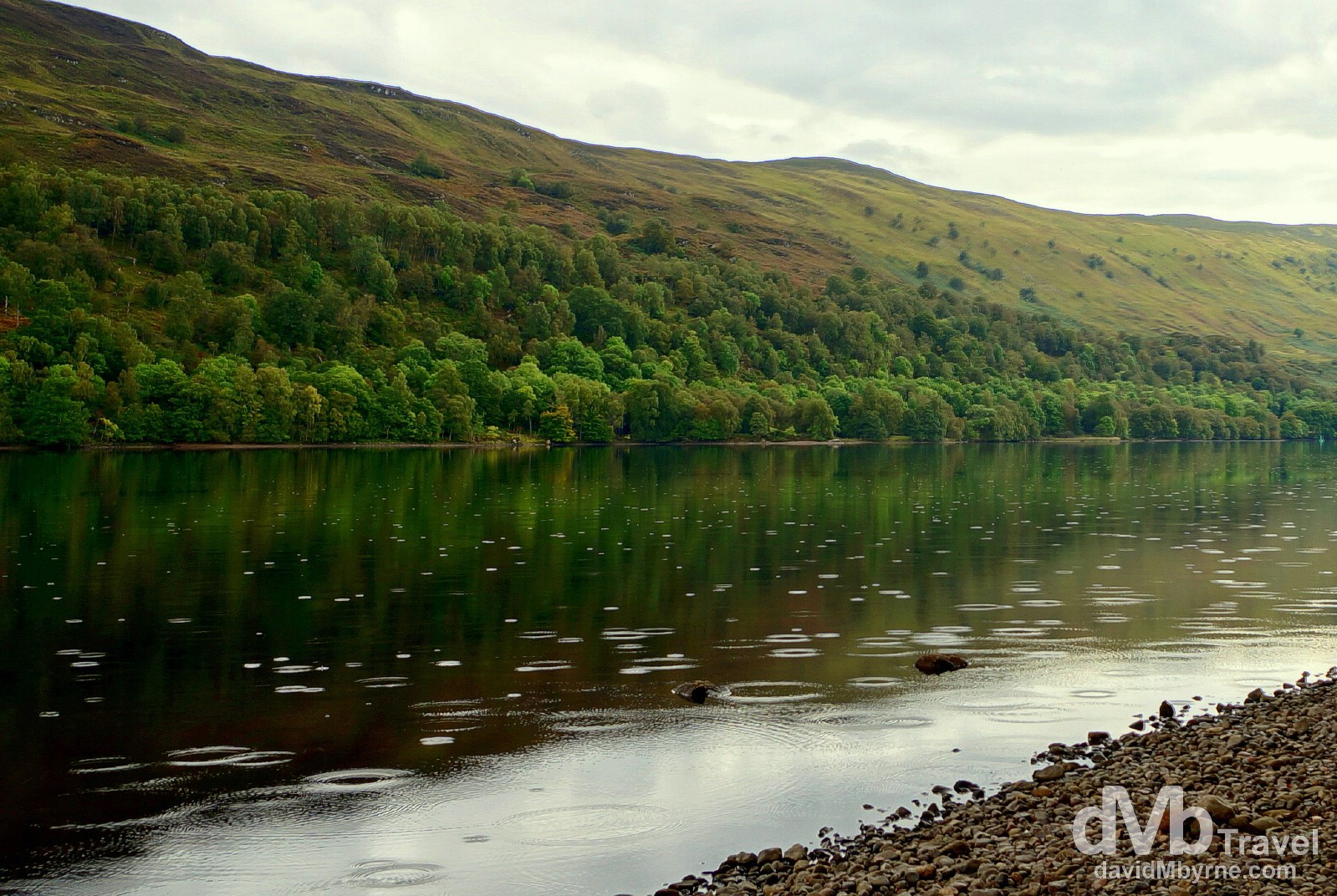
Light rain disrupts the mirror-like reflections on Loch Oich in Highland, Scotland. September 16, 2014.

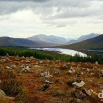
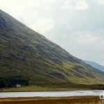
Memorial rocks on a hill overlooking Glen Shiel, Highland, Scotland, not far from the Isle of Skye. September 16, 2014.
Scuppered on Skye
We’re overnighting tonight in somewhere called Kyle of Lochalsh – locals, not that there are many of those around come nightfall, simply call their laid-back village Kyle. We had lunch here earlier today (a late lunch admittedly but lunch nonetheless) in Hector’s Bothy Café, a Kyle institution, before driving across the new (as of 1995) Skye Bridge connecting the village, and the Scottish mainland, to the Isle of Skye, the largest of Scotland’s Inner Hebrides islands. We had planned on bedding down in Portree, Skye’s largest town, for the night. The only problem was there were/are no free beds. Not in Portree, not anywhere on Skye, somewhere firmly on the tourist trail. The island is awash with B&Bs, hotels & guesthouses, but not one of them, not even mid-week in mid-September, could accommodate us. Yes, a popular place is Skye, very popular. So after a bit more driving than planned today (we drove 220 miles on day 7) we’re now back in Kyle having been forced to drive back off the island. We did manage to find a room for the night here, on the third floor of the has-seen-better-days Lochalsh Hotel. We’ll drive back over the Skye Bridge again in the morning and take a proper look at the Isle of Skye, billed as the location of some of Scotland’s most dramatic scenery. I, & in between staring at countless ‘No Vacancy’ signs, saw enough of the island already this evening – and what a beautiful evening it was – to get an initial appreciation for just how beautiful this part of Scotland is. Here’s hoping it is still as drop-dead gorgeous tomorrow.
Day 8 || September 17, 2014
Posting Location: Fort William, Highland
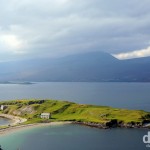
Although we’ve a few days left, today, day 8 of the road trip, was our last full day in the Scottish Highlands. Over the past 7 days we’ve been undoubtedly blessed with both scenery (of course we have, we’re touring Scotland) & weather (& pleasant surprise) but for today it might just have been a case of leaving the best for last. We spent the day touring the Isle of Skye, the largest of Scotland’s Inner Hebrides islands & one noted for its stunning & rugged mountain scenery, among other splendours. But before we drove (back) onto the island from the mainland we drove a short distance out the A87 road from our overnight base in Kyle of Lochalsh to get a distant look at Skye, Loch Alsh & the somewhat controversial Skye Bridge.
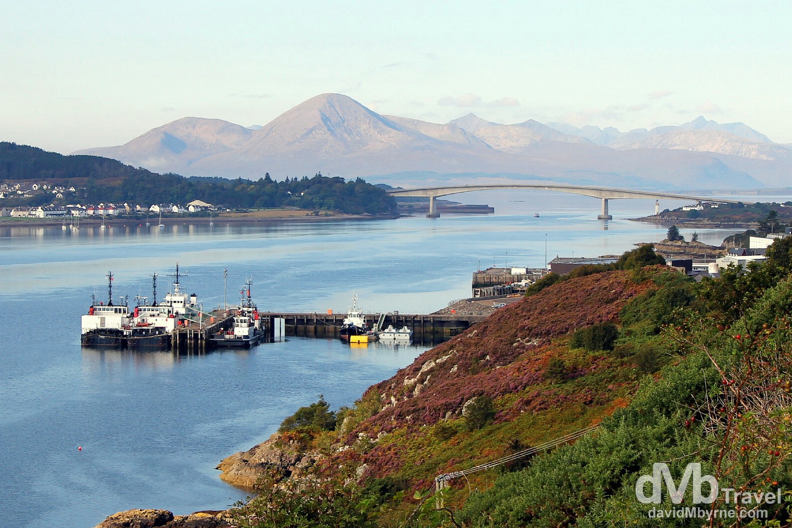
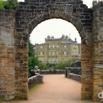
The mountains of the Isle of Skye & The Skye Bridge spanning Loch Alsh as seen from the A87 entering Kyle of Lochalsh. From approximately 1600 until the late 1995 opening of the Skye Bridge, ferries were the only way to get from Kyle of Lochalsh (right), on the Scottish mainland, across Loch Alsh to the village of Kyleakin (left) on the Isle of Skye. The bridge, controversial even during the planning stages, was tolled until its late 2004 purchase by the Scottish Executive with hefty fees for crossing (almost £6 each way for summer visitors) making it arguably the most expensive road in Europe. The bridge, which we crossed to get to the island, & the Armadale-Mallaig car & passenger ferry, which we took to leave the island later on this day, are now the only year-round connections from the Isle of Skye to the Scottish mainland. Klye of Lochalsh, Highland, Scotland. September 17, 2014.
Isle of Skye
The Isle of Skye, the largest and most northerly island in the Scottish Inner Hebrides, may be home to Scotland’s oldest continuously inhabited castle (Dunvegan Castle, home of the Clan MacLeod) & one of the country’s most famous distilleries (Talisker), but it’s the island’s raw scenic beauty that most people come here to enjoy. The product of violent geographical upheavals, the Misty Isle is justly famed for its scenery, for its towering, ragged mountains, colourful patchwork of crofting villages (farmlands), & wild, rugged coastline. And it’s predominately that wild, rugged coastline, following a series of peninsulas and bays radiating out from a mountainous centre, that we explored today, a day of crystal clear skies & stunning vistas. Here are a few pictures.
More reflections, this time off the A87 on the Isle of Skye, Scotland. September 17, 2014.
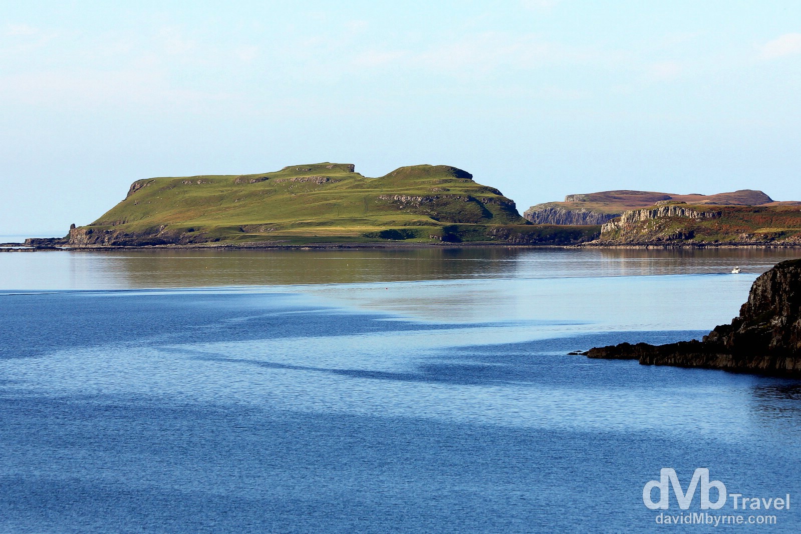
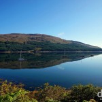
Coastal scenery at Loch Harport on the Isle of Skye, Scotland. September 17, 2014.
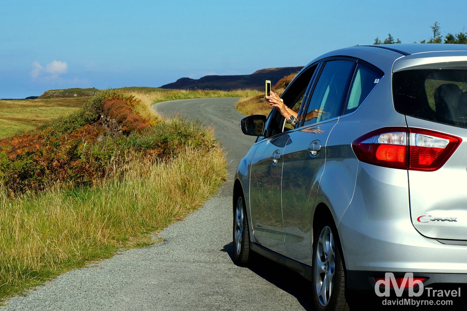
You don’t even need to get out of the car to capture Skye’s beauty. It’s everywhere. We spent the day driving a loop of the largest of Skye’s two rugged peninsulas, the Vaternish & Trotternish Peninsulas. When we got to the tip of the 12 kilometer long Vaternish Peninsula we decided to drive the narrow, windy, sometimes unpaved road until the road was no more. That’s Skye – loop roads & dead ends with beauty all around. Capturing the magic of Skye from the car on the narrow roads of the Vaternish Peninsula, Isle of Skye, Scotland. September 17, 2014.
The village of Uig & Uig Bay off the west coast of the Trotternish Peninsula. Remember photographers, NEVER shoot directly into the sun. It washes out the scene & you’re likely to get nasty lens flare. Or then again, if you’re lucky you might just get something presentable. We pulled over because of the view. Given the sun’s position I hadn’t initially planned on photographing this scene but now I’m glad I did. Overlooking Uig on the Trotternish Peninsula on the Isle of Skye, Scotland. September 17, 2014.
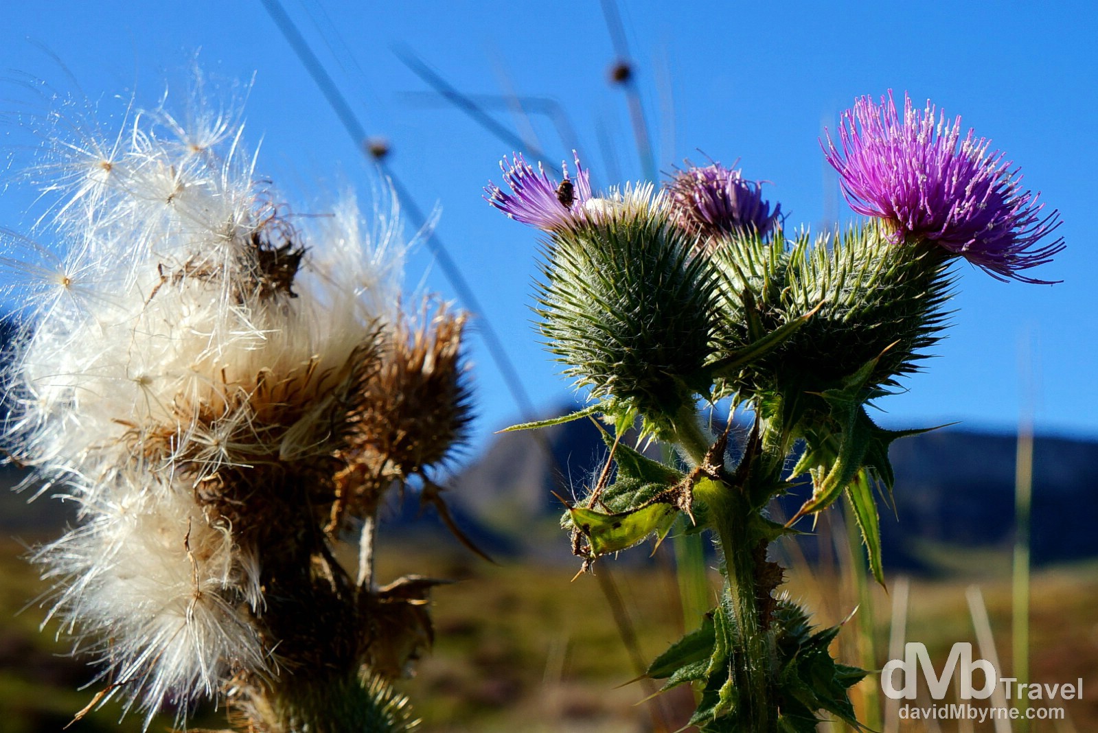
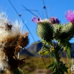
I’d photographed many a Highland thistle, a Scottish icon, over the previous days of the road trip but the thistles I found off the A855 at the tip of Skye’s Trotternish Peninsula were the first ones that actually photographed well. Isle of Skye, Scotland. September 17, 2014.
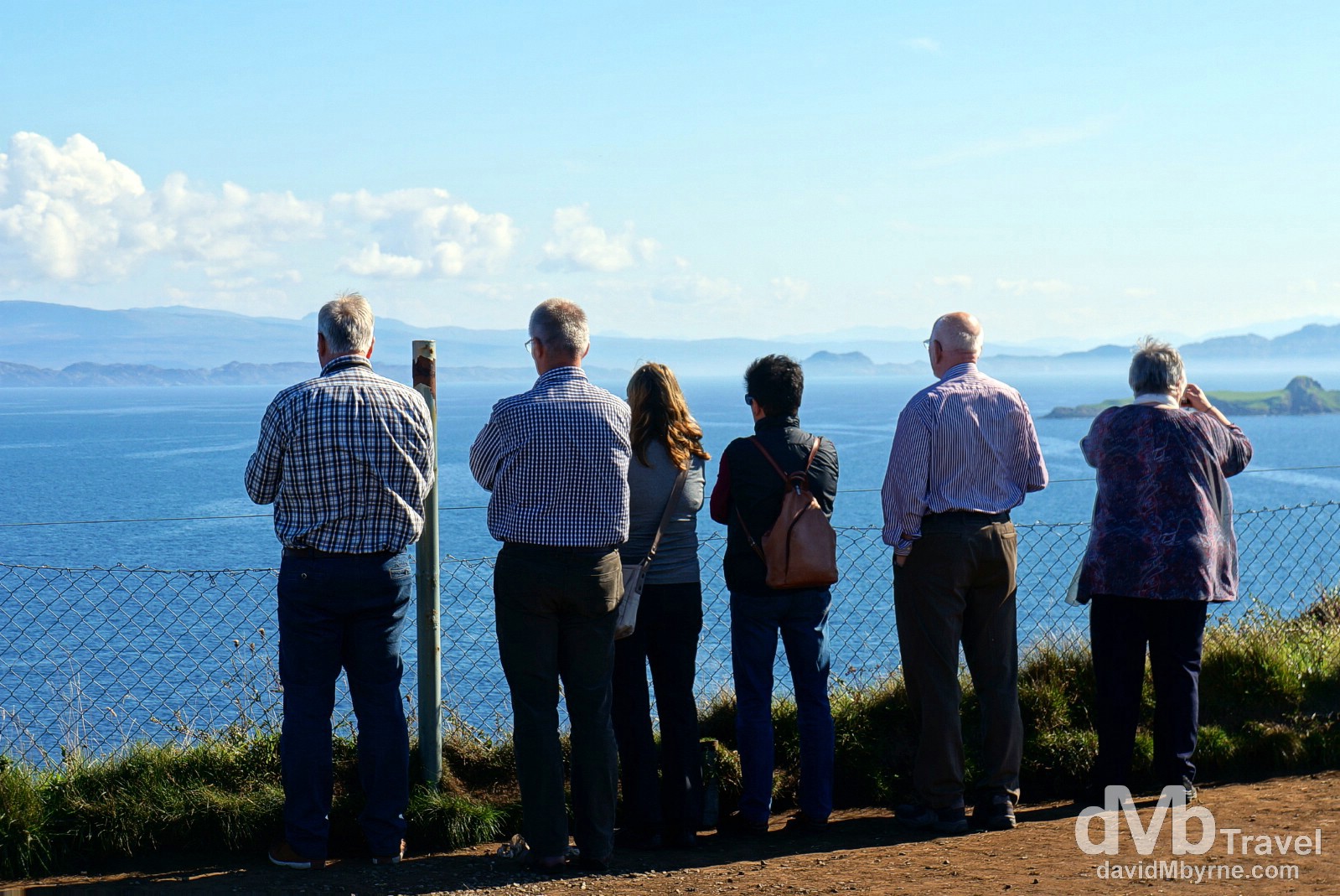
Looking out over the Sound of Raasay from the Kilt Rock viewpoint on the Trotternish Peninsula. Kilt Rock are pillars of rock forming a cliff on the eastern side of the Trotternish Peninsula. A Skye landmark, they were formed over 55 million years ago by the same volcanic activity that formed the island’s mountainous interior. I did photograph the pillars/cliff but preferred this picture of people gazing out over the Sound of Raasay from the Kilt Rock viewpoint. Isle of Skye, Scotland. September 17, 2014.
Back on the Mainland
We drove 211 miles today but covered more ground than that as we took the ferry across the Sound of Sleat from Armadale on Skye’s Sleat Peninsula to Mallaig on the Scottish mainland. From there it was a short 43 mile drive to Fort William, our present location & stop for tonight. We’re still in the Highlands, but only just & only for one more night. After entering them on day 4, we’ll leave the Highlands tomorrow, day 9, spending the rest of our time in the county (2 days) in the Lowlands. The so-called Lowlands they may be but we’re sure Scotland has a few more highs in store for us.
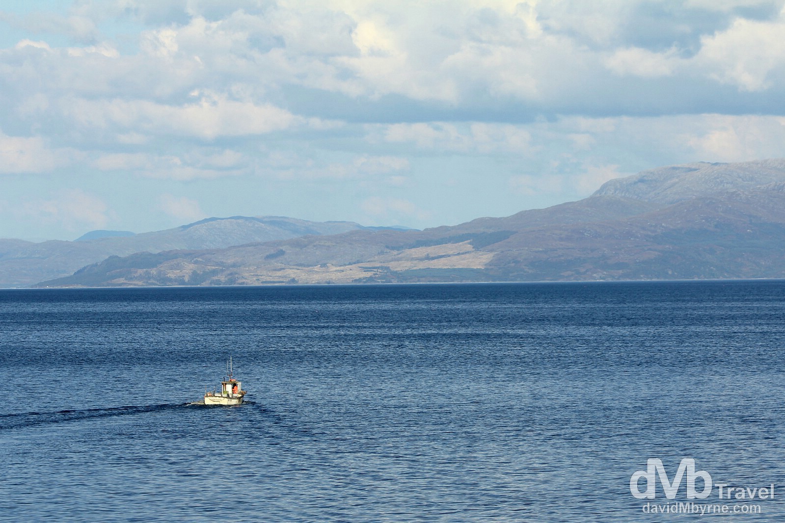
A boat on the waters of the Sound of Sleat as seen from the Armadale to Mallaig ferry crossing. The weather held out for the whole day and there was barely a breeze on the deck of the ferry as it crossed the narrow Sound of Sleat from Skye to Mallaig on the Scottish mainland. A glorious end to a glorious day. Sound of Sleat, Western Scotland. September 17, 2014.
Day 9 || September 18, 2014
Posting Location: Irvine, Aryshire
Today, September 18, 2014, was/is a momentous day in Scottish history. It’s independence referendum day. I’ve just posted about how special it is to be here on this day & as I type now the votes have been cast and the country, & the world, awaits the word, a simple ‘Yes’ or ‘No’, of the Scottish people. Earlier today, & while Scots were voting on their future, we kept busy. Very busy. We saw an historic steam train in motion; we saw an historic canal in action; we saw a great big, hulking lump of rock, Scotland’s highest; we saw a great big glen, Scotland’s most scenic; & we saw a great big loch (lake), Scotland’s largest. Oh, and we also finished the loop, returning to the outskirts of Glasgow, Scotland’s largest city, 9 days after we first arrived and 7 days after first leaving it. Yep, all in the one day, 147-mile day 9, the penultimate day of the ongoing road trip.
The Jacobite || An Historic Steam Train
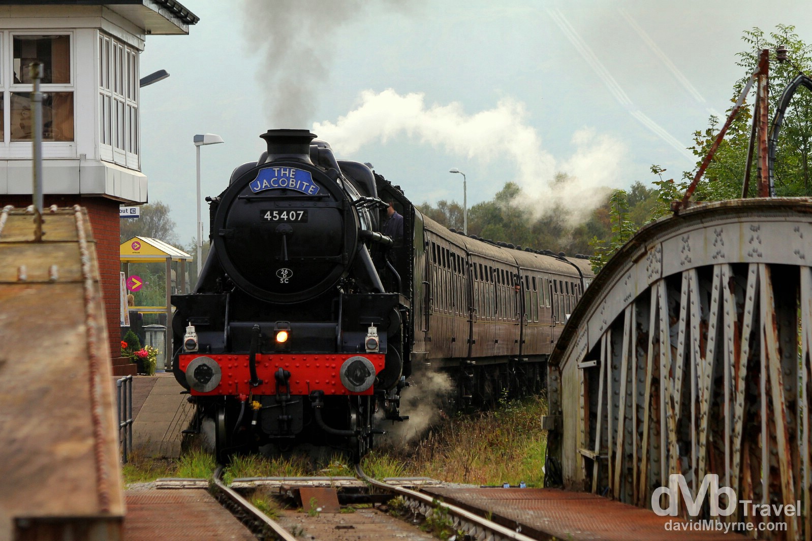
The famous Jacobite steam train passing through Banavie station. Described, by the operators of course, as one of the great railway journeys of the world, The Jacobite is a steam locomotive hauled tourist train service that operates between the Highland towns of Fort William & Malliag, where we disembarked the ferry from the Isle of Skye yesterday evening. The 41 mile stretch of track, most of it through areas of immense scenic beauty, was opened in 1909 as part of a railway expansion west in a bid to open up the remote & rural Scottish Atlantic Coast. The route was never a success & service was finally withdrawn in 1967. However, it wasn’t until 1984 that the track was reopened as the tourist attraction it still is today, huffing & puffing its way between the two aforementioned towns, although only from mid-May through the end of October. Banavie, Highland, Scotland. September 18, 2014.
Caledonian Canal || An Historic Canal
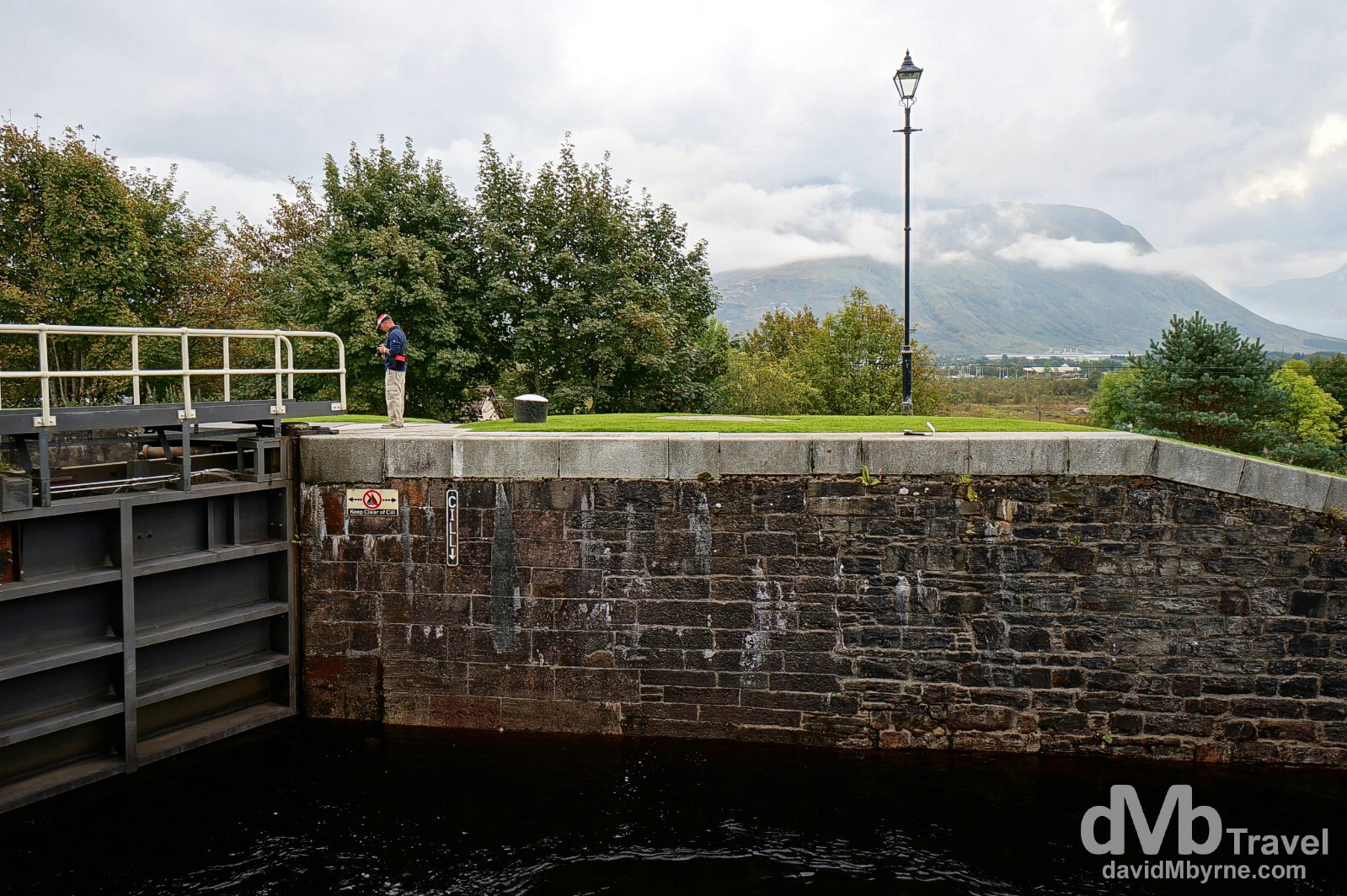
We drove the short distance (4 kilometres) from Fort William to Banavie primarily to see the locks of the Caledonian Canal. However, we got more than we bargained for as not long after we arrived The Jacobite passed through Banavie Station (as shown in the above picture) and a vessel stared its west coast/Atlantic Ocean to east coast/North Sea journey through the locks of the canal.
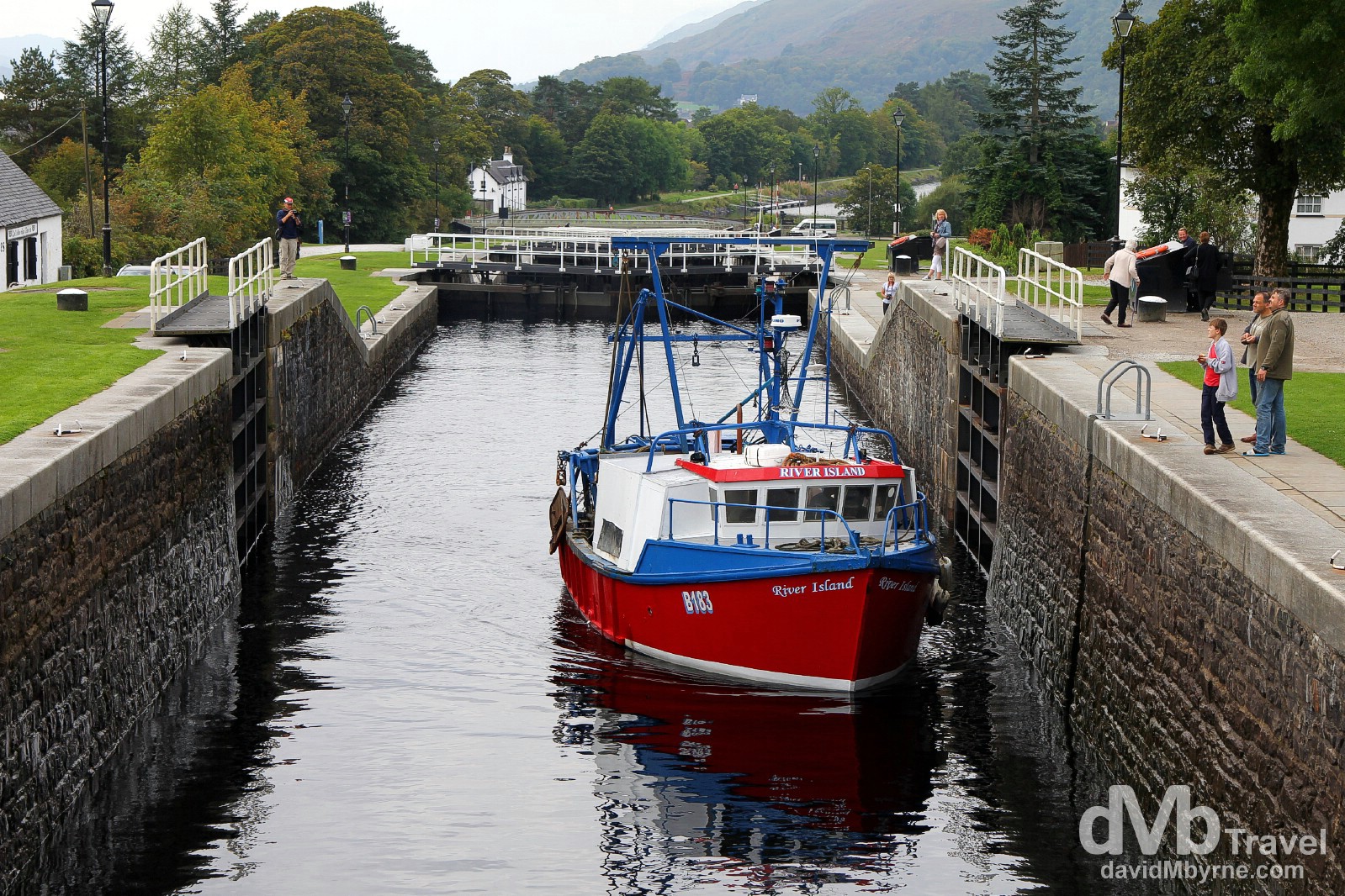
A fishing boat navigating the Neptune’s Staircase of the Caledonian Canal. Designed by the great Scottish Civil engineer Thomas Telford, construction on the wider Caledonian Canal started in 1803, finishing 19 years later & only 12 years behind schedule – seemingly the workers of the day were not very reliable. It was the very first state-funded transport undertaking in British history & the canal remains under public ownership to this day. It is 96.5 kilometres long, only 35.4 kilometres of which is man-made, the rest been formed by the 3 natural freshwater lochs of Lochy, Oich & Ness that sit astride the Great Glen Fault, the massive geographical fault that splits the Scottish Highlands, perfect canal territory. The canal has 29 locks in total & when travelling through it in a southwest-northeast direction (from the Atlantic Ocean to North Sea) this, the locks of the Neptune’s Staircase, are the first series, or flight of lock gates you encounter. Named after the Roman god of the sea, the 8 locks of the Neptune’s Staircase lifts (or lowers) boats 19.5 metres (64 feet) over a 457 metre long continuous stretch of solid masonry. It takes a boat about 1.5 hours to pass through the 8 locks, & about 14 hours total over 2 days to travel the whole canal from sea to sea. Up until the 1960s, 12 men were employed to open & close the lock gates of the Neptune’s Staircase by sheer brute force, a process that was mechanised in the 1960s (god bless hydraulics). Today only 2 lock-keepers are needed to push a few buttons, keepers who were more than happy to answer questions posed by us as we watched the boat seen here making its way through the lock gates. Banavie, Highland, Scotland. September 18, 2014.
– Robert Southey (1774-1843), poet, commenting on the Neptune’s Staircase of the Caledonian Canal
Ben Nevis || A great Gig, Hulking Lump of Rock
Ben Nevis is the dominant feature in this part of the world. It doesn’t look like a classic mountain, more a huge, ugly, hulking lump of rock, one that, at 1,344 metres (4,409 feet) high, is Scotland & the UK’s highest peak. It was nicely illuminated by the evening sun upon arrival in Fort William yesterday, day 8, but today as we stood by the Neptune’s Staircase of the Caledonian Canal it was shrouded in cloud. As I said, just a big, ugly, hulking lump of rock. Banavie, Highland, Scotland. September 18, 2014.
– Denise Mina, Scottish crime writer and playwright
Humour & wit is all over Scotland. It’s one of the many reason I like it here and why I have always liked the Scots themselves. I took a few pictures of signs & text that brought a smile to my face over the course of the road trip. This picture was captured on High Street in Fort William. It’s a nice town. It’s not a big place but is still the second largest settlement in the Scottish Highlands (after Inverness), not to mention our last stop in the Highlands. Boo hoo. Fort William, Highland, Scotland. September 18, 2014.
Glen Coe || A Great Big Glen
We drove the short distance (26 kilometres) from Fort William to Glen Coe, often considered one of the most spectacular and beautiful places in Scotland.
A narrow glen of volcanic origins but shaped by glaciers & ice sheets, U-shaped Glen Coe is one of the most popular tourist attractions in Scotland, especially with hill walkers and hikers. Often held up as the posterboy for Scottish Highland beauty, the 16 kilometre long glen is surrounded by wild and precipitous mountains, mountains that seem more imposing than they actually are given the glen’s narrow dimensions – the floor of the glen, which the A82 road follows, is less than 700 metres wide. The glen’s dramatic beauty is well known and undeniable but on this particular day the inclement weather meant it wasn’t looking its best. This picture was taken near the western entrance to the glen, not far beyond the village of Glencoe, infamous as the location of the February 1692 Massacre of Glencoe when 38 men, women & children were killed by troops carrying out government orders. One of the glen’s predominant features, the River Coe feed Loch Achtriochtan, is in the foreground with the sun, spotty at best for most of the day today, (just barely) shining on the steep lower slopes of Bidean nam Bian, the glen’s dominant mountain. Glen Coe, Highland, Scotland. September 18, 2014.
Loch Lomond || A Great Big Loch
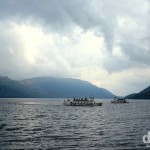
Some 75 kilometres beyond Glen Coe we reached the northern reaches of Loch Lomond, a freshwater loch lying on the Highland Boundary Fault, the boundary between the Scottish Highlands & Lowlands.
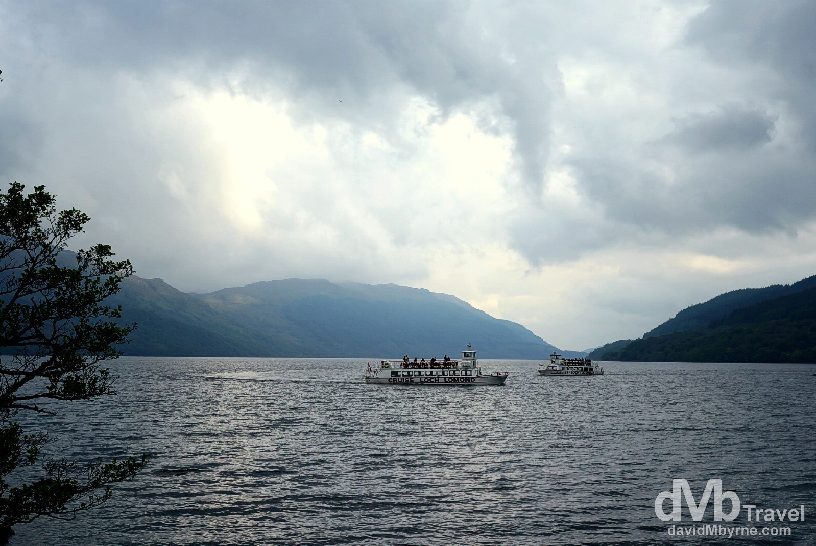
At 40 kilometres long & home to numerous islands, Loch Lomond is the largest body of water in Britain. This obviously makes it Scotland’s largest lake too, not to mention a popular boating location. Cruise Loch Lomond tour boats on Loch Lomond as seen from the Visitor Centre in Inveruglas, Loch Lomond and the Trossachs National Park, Scotland. September 18, 2014.
High To Low
One really gets an appreciation for how small Scotland is when within the space of a less than an hour you can drive from the peaceful calm of Highland glens, lakes & one-lane roads to the bustle of rush hour traffic on clogged multi-lane motorways on the outskirts of Glasgow, the country’s biggest city. That happened to us today en route from Loch Lomond and the Trossachs National Park to Irvine in Aryshire, our present location & overnight location for tonight, day 9 of the road trip. Yes, we’re well & truly out of the Highlands now. We’re in the home straight now with only one day left of this adventure.
Day 10 || September 20, 2014
Posting Location: Ary, Aryshire
It felt like we were on a mission today, the final day of our 10-day jaunt around Scotland. And I guess we were. We had two boxes we still wanted to tick and so today we drove some 191 miles in doing so, for a complete 10-day road trip total of 1,468 miles (2,362 kilometres). First up was Lockerbie, a town in Dumfriesshire not too far (30 kilometres or so) from the border with England, a sleepy town that was forever changed by the events of December 21, 1988.
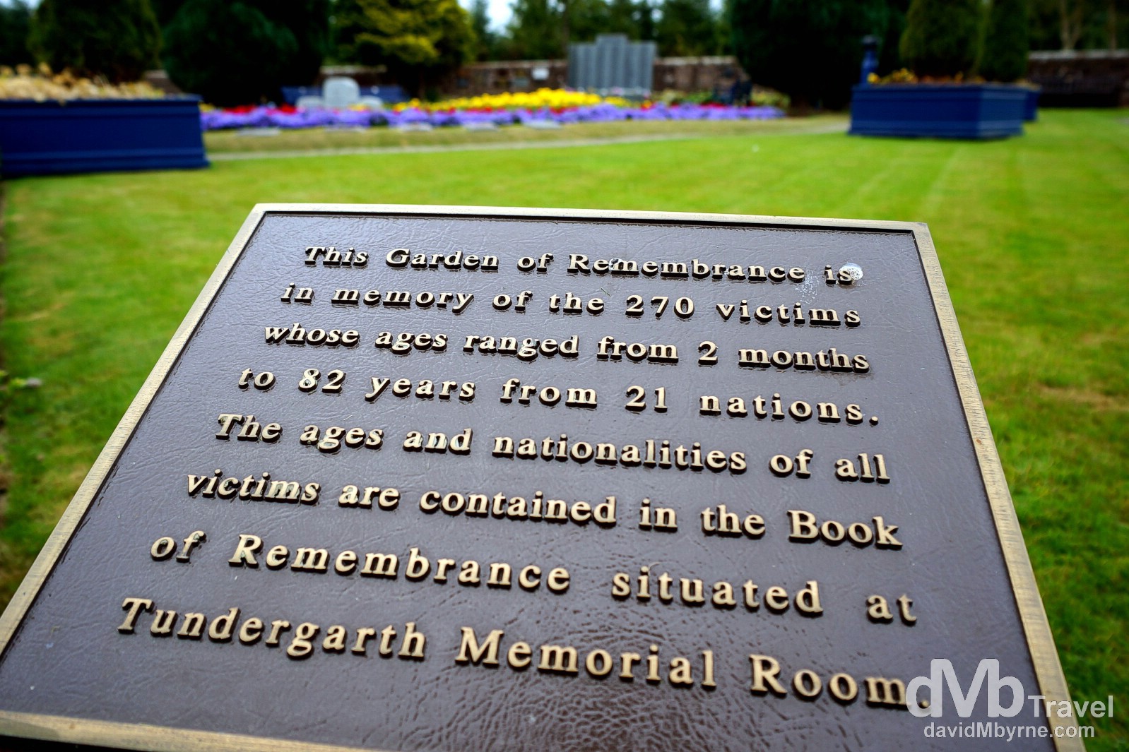
The Garden of Remembrance to the worst aviation disaster in British history in Dryfesdale Cemetery, Lockerbie, Dumfries and Galloway, Scotland. September 19, 2014.
The Lockerbie Bombing
Just after 7 p.m. on December 21, 1988, the Pan American flight 103, a Boeing 747 “Maid of the Seas”, suffered an explosion at 31,000 feet over Lockerbie. All on board, 243 passengers & 11 crew members, were killed, as were 11 residents of Lockerbie. Because the aeroplane broke up at such a great height, wreckage was spread over a wide area (over 2,000 km²), with major parts – the cockpit, a large part of the fuselage, the wings, & two engines – coming down in or around Lockerbie itself; it was the wings, laden with fuel & coming down on a Lockerbie housing estate, Sherwood Crescent, that killed those on the ground while destroying many houses and creating a huge creator that remains to this day. The subsequent police investigation was the biggest ever mounted in Scotland and became a murder inquiry when evidence of a bomb was discovered. Two men accused of being Libyan Intelligence Agents were eventually charged with planting the bomb. Abdelbaset Ali al-Megrahi, the only man convicted of the crime (his co-accused, Al Amin Khalifa Fahima, was acquitted), was jailed for life in January 2001 following a 3-month trial under Scottish law at Camp Zeist in the Netherlands. He was released from Barlinnie Prison in Glasgow on compassionate grounds in August 2009. It was thought he had only months to live as he had terminal prostate cancer, but he lived on to see the fall of Colonel Gaddafi in Libya (in August 2011) before finally succumbing to his illness at the age of 60 in May 2012, almost 3 years after his release.
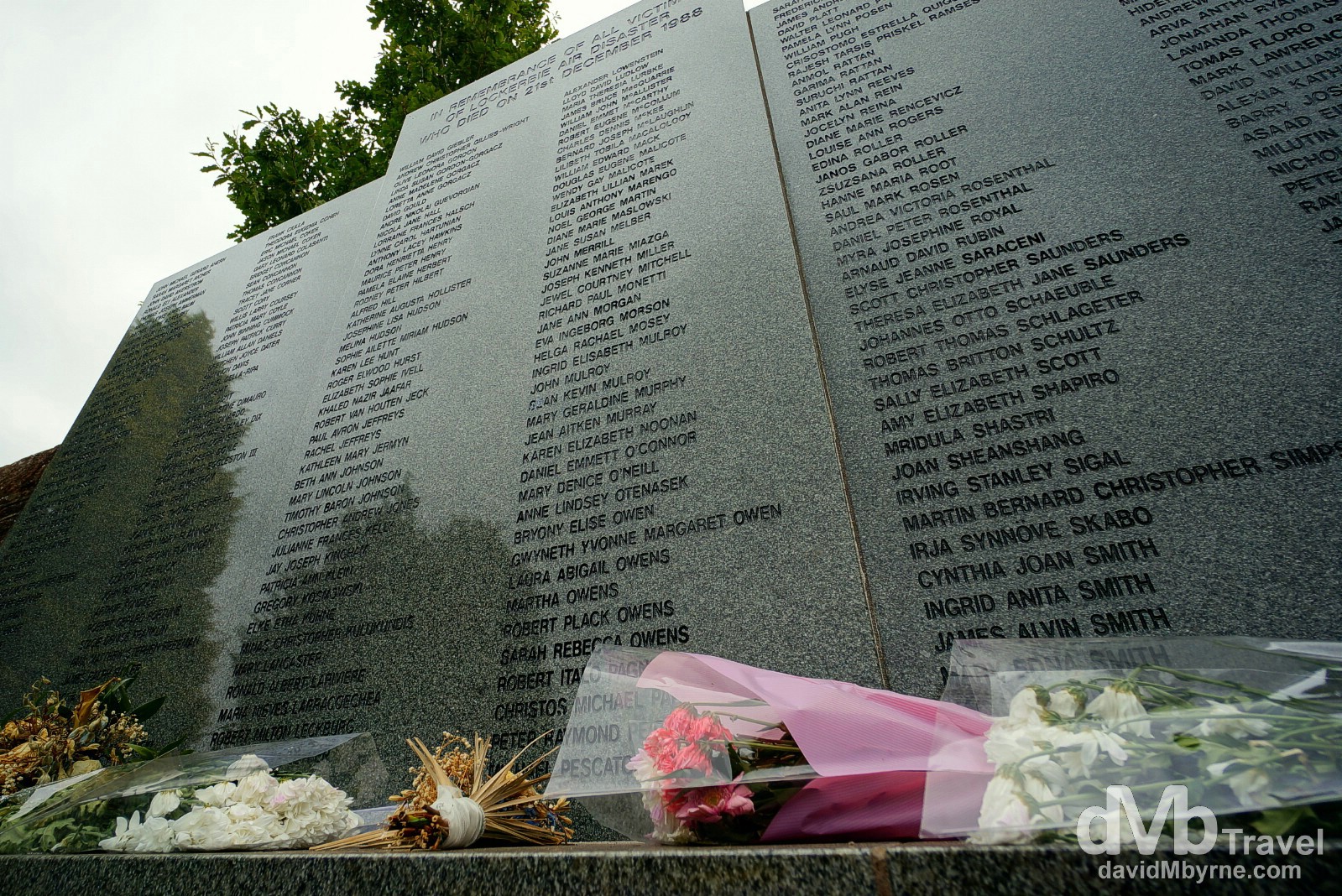
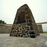
There are a number of memorials to those killed by the Lockerbie Bombing in and around Lockerbie itself, not to mention overseas, but the main focus for remembrance in Scotland lies just under a mile west of Lockerbie in Dryfesdale Cemetery, the location for the Garden of Remembrance. The garden lies at the back corner of the cemetery, a tranquil setting in which to think about those who lost their lives in the skies above the town and on the ground. The garden is dotted by individual memorials but its centrepiece is the Lockerbie Air Disaster Memorial, a grey granite slab arranged in the form of a triptych & bearing the names of all 270 victims. The Lockerbie Air Disaster Memorial in the Garden of Remembrance, Dryfesdale Cemetery, Lockerbie, Dumfries and Galloway, Scotland. September 19, 2014.
Dryfesdale Lodge Visitors’ Centre
Near the entrance to the Dryfesdale Cemetery is the Dryfesdale Lodge Visitors’ Centre. This was originally the cemetery caretaker’s cottage, but since 2003 has served as a centre for the local community & for visitors to Lockerbie, particularly for visitors to the Garden of Remembrance and Lockerbie Air Disaster Memorial. A number of rooms have been converted to accommodate information about the area and the air disaster with a Book of Remembrance available for signing. On our visit the centre was manned by a very informative local volunteer. It was clear that she had mixed feelings about Lockerbie’s infamy; on one hand the locals don’t like how their sleepy little village will always be associated with Britain’s worst aviation disaster, whereas on the other they are grateful that with the crash occurring over land (schedule delays meant flight 103 should have been over the Atlantic Ocean at the time of disaster) investigators were eventually able to discover the cause & bring the perpetrators to justice.
Culzean Castle
After the sobriety of Lockerbie, it was a 2-hour, 141 kilometre drive to Culzean Castle, maybe, just maybe, Scotland’s most fabulous castle.
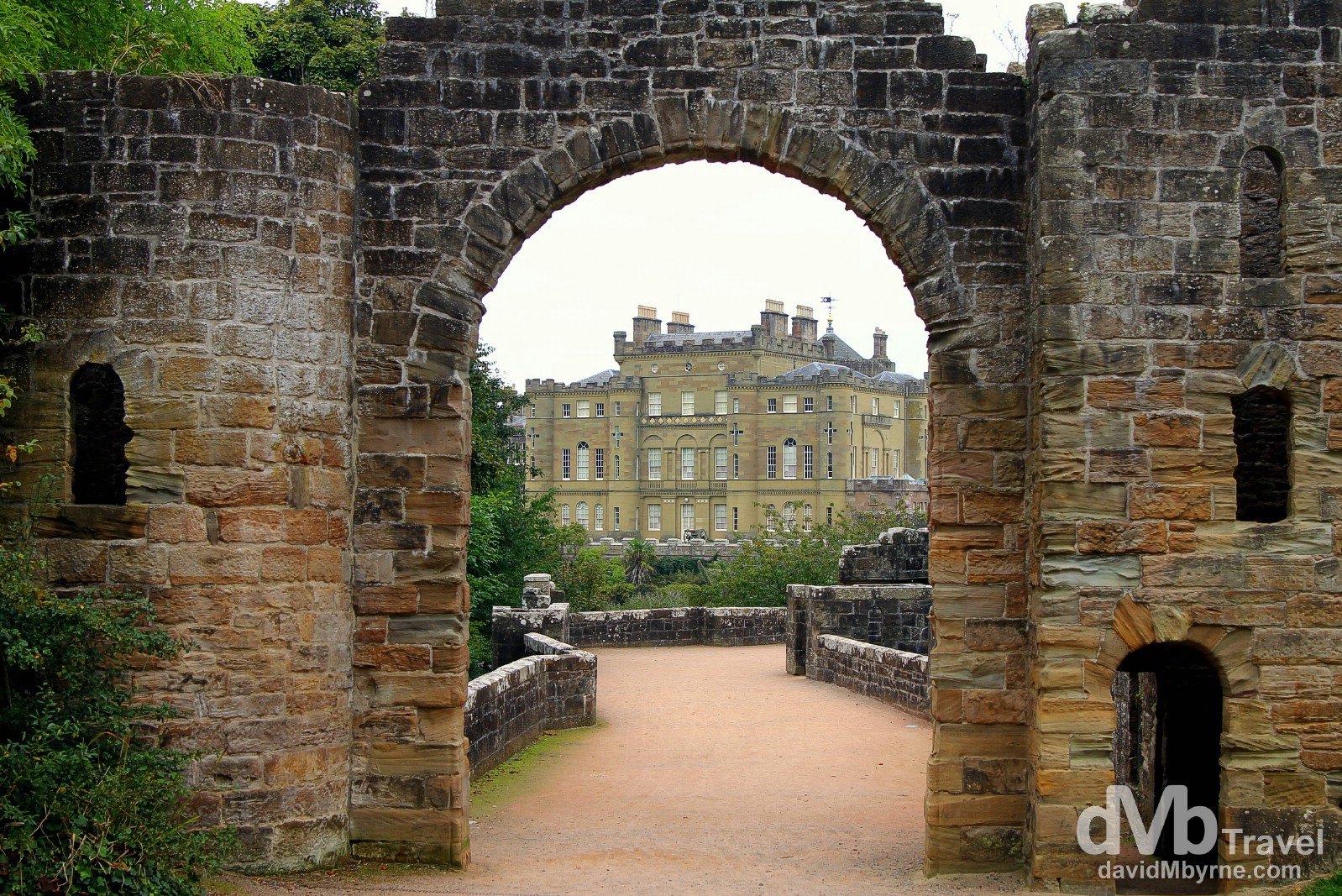
In a previous life Culzean Castle was, or so they say, a rather dull fortified tower house. The former home of the Marquess of Ailsa, the chief of Clan Kennedy, it was transformed by the architect Robert Adam, the most famous architect of his day. The Culzean project, which Adam was given full artistic licence over & on which no expense was spared, was to be his final masterpiece and over a period of some 15 years, beginning in 1777, he transformed it into a mansion of sumptuous proportions and elegance. Today in a land of magnificent castles it’s probably the most magnificent of the lot. In 1945, the Kennedy family gifted Culzean to the nation. It was fully restored in the 1970’s and is now owned by the National Trust of Scotland & open to the pubic. Oh, and since 1987 an illustration of the castle has featured on the reverse side of five pound notes issued by the Royal Bank of Scotland. Yes, it’s iconic. Culzean Castle, Ayrshire, Scotland. September 19, 2014.
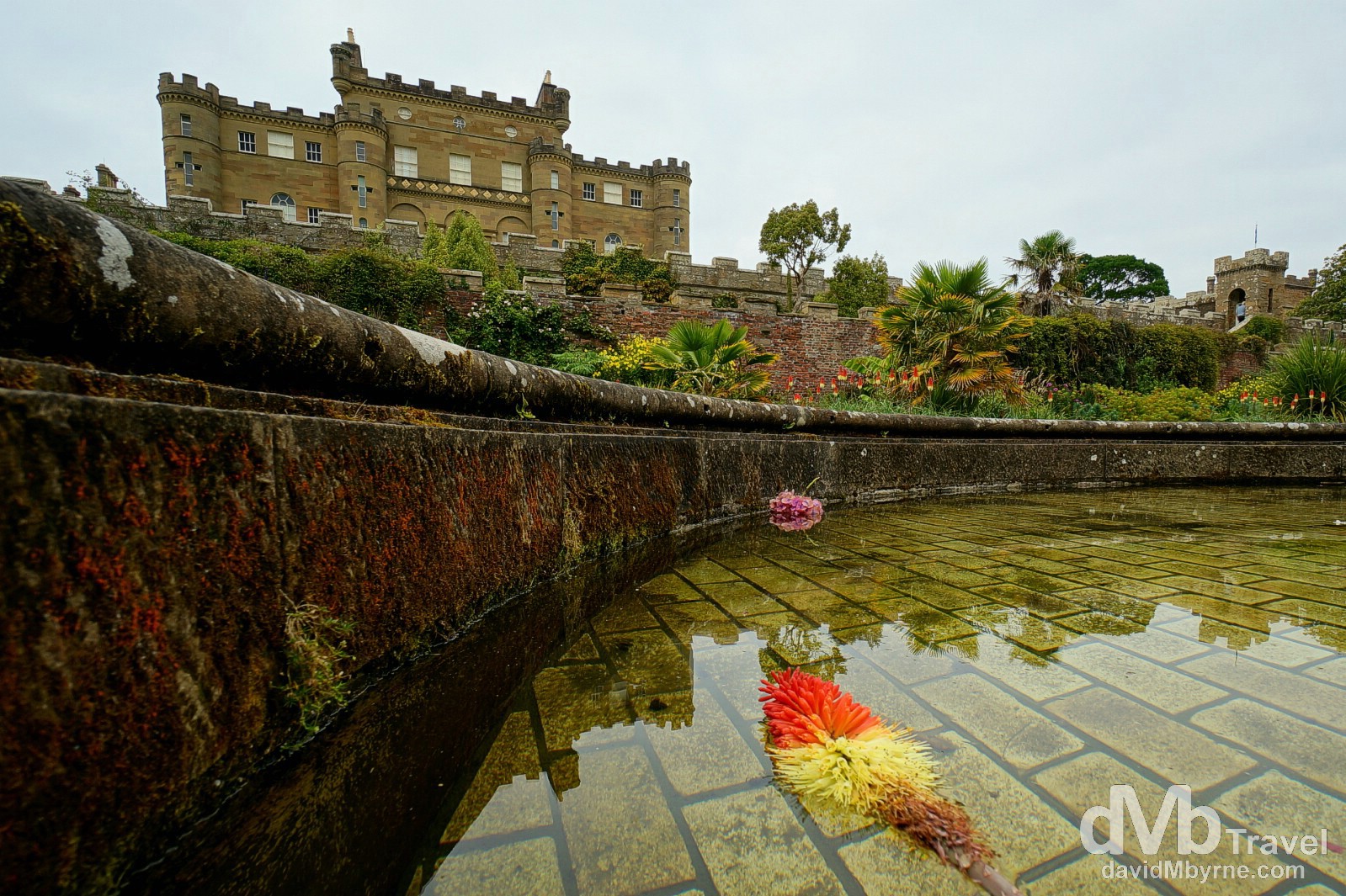
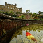
Perched on a cliff top overlooking the Firth of Clyde in Aryshire, the castle is a remarkable vision of turrets and battlements. Fronting the ocean, on three sides Culzean is surrounded by 242 hectares of stunning countryside, grounds that became Scotland’s first public country park in 1969. The estate is peppered with wild & walled gardens, charming follies and miles of woodland trails just waiting to be explored. This picture was captured in the beautifully manicured gardens fronting the castle, showing a portion of the decorative water fountain that dominates the centre of the garden. Culzean Castle, Ayrshire, Scotland. September 19, 2014.
As impressive as the castle’s exterior is, its interior is equally so. Just make sure to bring a wide-angle lens with you as you embark on the highly recommended self-guided tour.

The castle interior boasts more than a few impressive rooms with this, the spectacular Oval Staircase, stealing the show. A three-storey tower with ancient Greek columns & decorative banisters all topped by a naturally illuminated dome, this is, according to the self-guided tour literature, Adam’s final masterpiece, an inspired but expensive solution to a shortage of space and the need to draw together the castle’s different building styles. Culzean Castle, Ayrshire, Scotland. September 19, 2014.
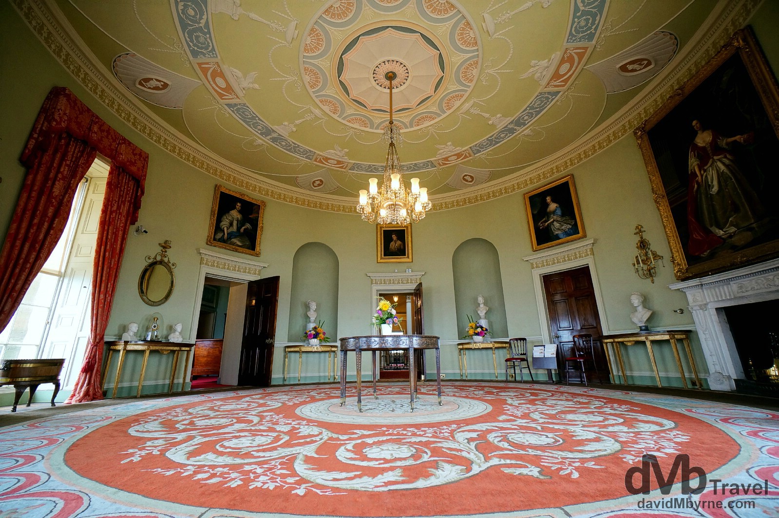
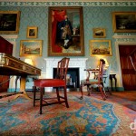
The Round Drawing Room was used as Culzean’s main reception room were people would mingle at social and political gatherings. The room boasts panoramic views over the Firth of Clyde, heightening the drama of Culzean’s cliff-top perch. The room’s dominant features are the carpet, a 1983 copy of the original that took four women two years to weave by hand, & the gasolier, the central lighting fixture that was fed by gas, courtesy of the castle’s own gasworks, until electricity arrived in Culzean in the 1950’s. Culzean Castle, Ayrshire, Scotland. September 19, 2014.
Culzean Splurges
There are other options at Culzean for spending money beyond the entrance fee to access the estate gardens (cheaper) or self-guided tour the castle interior (more expensive). Refreshments are available costing upward of £45/€57 per person for Champagne Afternoon Tea (what what) in the exclusive top floor Eisenhower Apartment, gifted by the Kennedy’s to the ex-US President Dwight D. Eisenhower in recognition for his role as Supreme Commander during WWII – Ike visited Culzean four times including once as President. Feel like getting married? Culzean can accommodate that too at prices aren’t overly outrageous – £150/€190 a head, give or take. Or you could just lay your head. The castle’s top floors are a hotel, one we were told may be accommodating high-profile sportsmen in the very near future. Umm. The Ryder Cup in Gleneagles starts in less than a week & is a very short commute from here by helicopter.
– Susan Eisenhower, granddaughter of Dwight D. Eisenhower
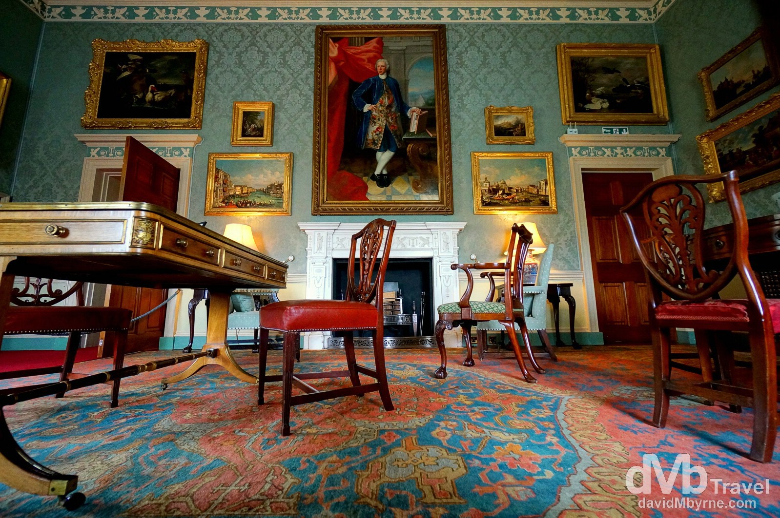
The Blue Drawing Room is the Culzean room that has changed least since Adam designed it. Used as gathering place for guests to enjoy drinks before dinner, the room is dominated by the 1820’s Rosewood writing table & the pure white marble chimneypiece over which is a massive 1746 portrait of Thomas Kennedy, the 9th Earl of Cassilis (1733-1775). Culzean Castle, Ayrshire, Scotland. September 19, 2014.
Scotland Road Trip || The Gallery
-

- Independence rally outside The Royal Glasgow Concert Hall in Glasgow, Scotland. September 11, 2014.
-
- Battle of Bannockburn memorial, Bannockburn, Scotland. September 12, 2014.
-

- A restored room in the Place of Stirling Castle, Stirling, Scotland. September 12, 2014.
-

- Ladies’ Lookout of Stirling Castle, Stirling, Scotland. September 12, 2014.
-

- Royal Mile, Edinburgh, Scotland. September 12, 2014.
-

- A section of the interior of St. Giles Cathedral in Edinburgh, Scotland. September 12, 2014.
-

- Forth Rail Bridge crossing the Firth of Forth, Scotland. September 12, 2014.
-

- Morning activity on Princess Street as seen from Calton Hill in Edinburgh, Scotland. September 13, 2014.
-

- Interested bystanders. Sheep by the side of the road in Cairngorms National Park, Scotland. September 13, 2014.
-
- Scenery in Cairngorms National Park, Scotland. September 13, 2014.
-

- On the platform of the gorgeous Victorian era train station in Aviemore, Scotland. September 14, 2014.
-

- Scenery near the Comarty Bridge crossing Cromarty Forth north of Inverness in Scotland. September 14, 2014.
-
- Deloitte Ride Across Britain 2014 participants celebrate completing the 9-day, 874 mile cycle from Land’s End by the post at John O’Groats in Scotland. September 14, 2014.
-

- The lighthouse on Dunnet Head, the most northerly point on the British mainland. Dunnet Head, Scotland. September 14, 2014.
-
- Silhouettes at Dunnet Head, the most northerly point on the British mainland. Dunnet Head, Scotland. September 14, 2014.
-

- St. Peter’s & St. Andrew’s Church overlooking Sir John Square in Thurso, Caithness, Highland, Scotland. September 15, 2014.
-
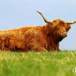
- A red Highland in a field outside the village of Reay, Caithness, Highland, Scotland. September 15, 2014.
-
- Overlooking Loch Eriboll, Sutherland, Highland, Scotland. September 15, 2014.
-

- Passing Place sign on the narrow roads of Sutherland, Highland, Scotland. September 15, 2014.
-
- Smoo Cave, the largest sea entry cave in the U.K. Sutherland, Highland, Scotland. September 15, 2014.
-

- A lone boat in the harbour of Ullapool, Highlands, Scotland. September 16, 2014.
-

- Ullapool, Highlands, Scotland. September 16, 2014.
-
- The town of Ullapool on the eastern shore of Lock Broom as seen from the A835 entering town. Highlands, Scotland. September 16, 2014.
-

- Reflections of the western shore of Lock Broom, Highlands, Scotland. September 16, 2014.
-
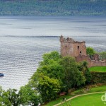
- The ruins of Urquhart Castle on the shores of Loch Ness, Highland, Scotland. September 16, 2014.
-
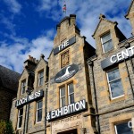
- The Loch Ness Exhibition Centre at the Drumnadrochit Hotel in Drumnadrochit, Inverness, Scotland. September 16, 2014.
-
- Admiring the reflections of Loch Oich in Highland, Scotland. September 16, 2014.
-
- A military cargo plane fly-by over the waters of Loch Oich, Highlands, Scotland. September 16, 2014.
-

- Light rain disrupts the mirror-like reflections on Loch Oich in Highland, Scotland. September 16, 2014.
-
- Memorial rocks on a hill overlooking Glen Shiel, Highlands, Scotland. September 16, 2014.
-

- The mountains of the Isle of Skye & The Skye Bridge spanning Loch Alsh as seen from the A87 entering Kyle of Lochalsh, Highland, Scotland. September 17, 2014.
-
- Reflections off the A87 on the Isle of Skye, Scotland. September 17, 2014.
-
- Coastal scenery at Loch Harport on the Isle of Skye, Scotland. September 17, 2014.
-

- Capturing the magic of Skye from the car on the narrow roads of the Vaternish Peninsula, Isle of Skye, Scotland. September 17, 2014.
-

- The village of Uig & Uig Bay off the west coast of the Trotternish Peninsula on the Isle of Skye, Scotland. September 17, 2014.
-
- A thistle, a Scottish icon, at the tip of the Trotternish Peninsula on the Isle of Skye, Scotland. September 17, 2014.
-

- Looking out over the Sound of Raasay from the Kilt Rock viewpoint on the Trotternish Peninsula, Isle of Skye, Scotland. September 17, 2014.
-

- As seen from the Armadale to Mallaig ferry crossing the narrow Sound of Sleat, western Scotland. September 17, 2014.
-
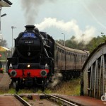
- The famous Jacobite steam train passing through Banavie station en route from Fort William to Mallaig in Highland, Scotland. September 18, 2014.
-

- A fishing boat navigating the Neptune’s Staircase lock of the Caledonian Canal in Banavie, Scotland. September 18, 2014.
-
- Ben Nevis, the tallest peak in the United Kingdom, as seen from the Neptune’s Staircase lock of the Caledonian Canal in Banavie, Highland, Scotland. September 18, 2014.
-
- Glen Coe, Highland, Scotland. September 18, 2014.
-
- Tour boats on Lock Lomond, Scotland. September 18, 2014.
-
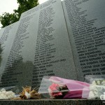
- The Lockerbie Air Disaster Memorial in the Garden of Remembrance, Dryfesdale Cemetery, Lockerbie, Dumfries and Galloway, Scotland. September 19, 2014.
-
- Culzean Castle, Ayrshire, Scotland. September 19, 2014.
-
- A section of the decorative water fountain fronting Culzean Castle, Ayrshire, Scotland. September 19, 2014.
-

- The amazing Oval Staircase of Culzean Castle, Ayrshire, Scotland. September 19, 2014.
-

- The Round Drawing Room of Culzean Castle, Ayrshire, Scotland. September 19, 2014.
-
- The Blue Drawing Room of Culzean Castle, Ayrshire, Scotland. September 19, 2014.